
The Rheinsteig is the high altitude hiking trail on the right bank of the Rhine on the Middle Rhine. The 320 km long route starts at Biebrich Castle in Wiesbaden on the banks of the Rhine and initially leads through the Rheingau to the Niederwald monument Rudesheim am Rhein and then continue on the right side of the slope Middle Rhine Valley about the Loreley, opposite the Ehrenbreitstein Fortress Koblenz, the Drachenfels in the Siebengebirge until after Bonn. The is on the left bank of the Rhine Rheinburgenweg of Bingen until shortly before Bonn at the Rolandsbogen.
background
In contrast to the Rheinhöhenweg, which mostly leads far away from the Rhine over the Taunus and Westerwald heights, the Rheinsteig, which opened in 2005, is still young with its many views and vineyards. Sometimes the Rheinsteig takes the same route as that Rheingau Riesling Path and the Hessenweg 7. Often the Rheinsteig runs one level higher and alternates between vineyard paths and forest paths.
A total of 8,000 blue and white marker signs were hung and 500 signposts with distance information were set up. Terrain protection in rocky places and rest areas were also created. Most of the time, however, you hike on wide paths, few of which are paved.
From all places on the Rhine there are Feeder routes to the Rheinsteig with yellow and white markings. And every place on the Rhine can be reached by train. in the Rheingau Several buses run every hour or two hours that reach the Rheinsteig.
Between Wiesbaden and Chew The Rheingau-Riesling-Path and the Hessenweg 7 run partly on the same, partly on parallel paths, so that even on short tours there is the possibility to take a different path for the way back.
From Rüdesheim onwards, the Rheinsteig was also separated from the right bank of the Rhine Rheinburgenweg who was a little less sporty and had largely the same route. There are still signs put up. Officially it no longer exists on the right bank of the Rhine, but on the left bank of the Rhine.
preparation

Sturdy shoes, sufficient water, maps are not absolutely necessary due to the very good marking. Due to the steep ascents and descents, the use of hiking sticks is recommended.
Waymarks on the OpenStreetMap map
- The Rheinsteig-Main path always has one Whiteit R. on blueem background, blue path.
- The Approach have a Whiteit R. on yellowen background, crimson path,
- The former Rheinburgenweg on the right bank of the Rhine has a redit RB on Whiteem background. Some of the trail markings are still there.
- The Rheinhöhenweg on the right bank of the Rhine has a blueit R. on Whiteem background, blue path.
- The Hessenwege have a redit H and > on Whiteem background, blue path.
- The Rheingau Riesling Path has a yellowit Y on greenem background, orange path.
For more path markings, see here.
The way back can be designed differently by combining these parallel paths and additional circular paths. Some circular routes:
- Rheinsteig circular tour Rauenthaler clasp, has a Whiteit R. on redon the background, purple path.
getting there
- Stadtexpress SE 10 from Frankfurt via Wiesbaden Central Station to Neuwied above Lahnstein and Koblenz main station (Stops every hour between Wiesbaden and Neuwied at every train station).
- In the Rheingau, some higher points can be easily reached by bus.
- Regionalbahn 27 and Regional-Express 8 from Koblenz main station above Neuwied, Bonn-Beul Köln Hbf. The regional express runs via Vallendar and Koblenz-Ehrenbreitstein.
For groups of up to 5 people, the Rhineland-Palatinate ticket is worth € 24 to € 40. It also applies to the Hessian railway section through the Rheingau and in the buses in Wiesbaden. On the stretch on the left bank of the Rhine it applies to Bonn Central Station, on the stretch on the right bank of the Rhine via Neuwied it is only valid up to Uncle. Otherwise, anyone traveling across the border between Hesse and Rhineland-Palatinate must buy a train ticket. That applies between Kaub and Unkel VRM tariff. Between Cologne, Bonn, Koenigswinter, Bad Honnef and the Rhineland-Palatinate places up to Neuwied and Engers, the transitional tariff applies VRS.
The Hessen-Ticket for 33, - € is only valid up to Lorchhausen. From Mainz and Wiesbaden the day ticket of the RMV at € 8.85 and group day ticket at € 15.80 cheaper.
Stages in the Rheingau

Markers for Rheinsteig: R.
The Rheinsteig mainly runs on the upper slopes and along the edge of the Taunus. In the Rheingau the slopes are still moderate and the paths are wide.
Wiesbaden-Biebrich - Schlangenbad: 16.3 km
1st stage: Incline: 544 m, descent: 324 m
Wiesbaden-Biebrich - Wiesbaden-Frauenstein

From 1 Wiesbaden-Biebrich train station![]()
![]()
![]() walk through the entire castle park past the Moosburg to the banks of the Rhine.
walk through the entire castle park past the Moosburg to the banks of the Rhine.

From Wiesbaden city center and main train station, take bus line 14 or 4, from Mainz Hbf and Mainz-Kastel bus 9 to 2 Stop "Rheingaustraße" or "Schloss Biebrich"
- 3 Biebrich Castle.


 in the Wikidata database")
 .
. - Schierstein harbor
- Nieder-Wallufer Bay nature reserve
- 4 Excursion restaurant and winery Nürnberger Hof
- 5 Goethestein. (Viewpoint) - Pyramid with portrait relief in memory of Johann Wolfgang von Goethe. · Short way from Bus 24 "Wiesbaden-Frauenstein Goethestein" from Wiesbaden center.
- 6 Spitzer Stein observation tower. Hilltop with observation tower, 254 m.
- 7 Frauenstein Castle
- Frauenstein Bus 24 "Herrnbergstraße" from Wiesbaden.


Wiesbaden-Frauenstein - Schlangenbad
City bus 24 from Wiesbaden to Frauenstein at the city rate (€ 2.70), every 20 minutes.
- Approach from Martinsthal
- Monstrance tree
- Berg Grauer Stein (340 m) - natural monument: rugged rock formation · Shortly afterwards: refuge
- South edge Georgenborn (332 m) on a short journey
- 1 Schlangenbad - thermal baths. (313 m) (.
Alternative tour: Hessenweg via Rauenthal to Kiedrich
- Martinsthal
- Rauenthal
- 1 Werner winery. with tavern and terrace, next to it on the meadow an overpriced wine tasting stand.
- 1 Boy's house height. - Small forest with a large swing and a beautiful view as far as Mainz.
- Further below: Gutsausschank Im Baiken
- The Rheingau Riesling path and Hessenweg 7 lead via the wine tasting town of Kiedrich to the town center Kiedrich. Before that, however, you meet the Rheinsteig on the narrow Wiesweg street, which goes over the Scharfenstein castle ruins.
.jpg/350px-Rauenthal_Bubenhäuser_Höhe_(vom_Eltviller_Sonnenberg).jpg)
The Rheingau Riesling Trail is also an interesting alternative.
Snake bath - Kiedrich − Eberbach Monastery: 9.6 km


2nd stage: Difficulty: medium, ascent: 235 m, descent: 366 m, duration: 3:00 h, highest point: 337 m (refuge on the Badweg)
Getting there: Bus 275 “Landgrafenplatz” from Wiesbaden Hbf and bus 173 “Seniorenresidenz” from Eltville train station to Schlangenbad.
Stage start:
- Schlangenbad thermal baths / Hotel Russischer Hof
- 1 Schlangenbad spa gardens
- 2 Rauentaler spring with Kneipp water treading facility. and rest area with a view.
- → Rauenthal Bus 170 and 173, as well as access from Martinsthal
- 2 Forest restaurant Rausch
- 1 View from the Graffenberg vineyard (220m). above Kiedrich.
- 2 Scharfenstein ruins. with all-round view, but locked tower.
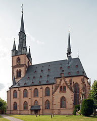
- Kiedrich (166 m) - The townscape, characterized by half-timbered houses, that of the 3 Valentinus Church is controlled. · Bus 172 "Sonnenlandstrasse", approach from the "Eltville" train station.
- 4 Eberbach Monastery (219 m) Bus 172 "Kloster Eberbach" (final stop) from Eltville train station, every hour.
- Klosterschänke with garden restaurant - daily: 11.30 a.m. - 10 p.m., warm meals throughout
- Bistro in the Pfortenhaus - from Easter up to and including autumn holidays, Wed. - Sun .: 9 a.m. - 6 p.m.

Eberbach Monastery - Kühn's Mühle - Vollrads Castle - Johannisberg: 11 km
3rd stage: Ascent: 284 m, descent 281 m. Bus 172 from Eltville train station to Kiedrich and "Kloster Eberbach" (every hour).
On this tour there is no connection to public transport between the Rebhang settlement and the Geisenheim districts of Johannesberg and Schlossheide.
- Eberbach Monastery Bus 172
- → Access from Hattenheim train station
- 2 Lookout point over the Steinberg domain. (260 m).
- → Domain Steinberg - state winery enclosed in walls with an underground cellar of the Eberbach monastery.
- 1 Schwarzes Häuschen - wine bar in the Steinberg. (195 m).Open: April-October: Fri from 2 p.m., Sat, Sun and public holidays from 11 a.m., in good weather until 10 p.m.
- → 3 Lookout point. (305 m). Relaxation bench and view of the Rhine Valley.
- 8 Bus 181 “Siedlung Am Rebhang” daily from Hattenheim train station, Mon.-Fri. also from Geisenheim train station via Marienthal Abbey.
- 4 Viewpoint refuge. (295 m). Below the Am Rebhang settlement.
- Susberg (331 m), including at the edge of the forest: 5 Refuge and view
- 6 Lookout point at the Philippsburg hunting lodge. (290 m).
- 7 Lookout hut in the vineyard. (235 m).
- 3 Kühn's mill. (195m). Pension, viticulture and bar with terrace.
- 5 Vollrads Castle. (160 m). Wine bar, pretzel and tarte flambée and seating at beer tables and uncomfortable wooden benches in the wonderful courtyard ambience. Gutsrestaurant with high prices.
- → Access (approx. 1 km) from Johannisberg Castle and the Johannisberg district on the Rheingau-Rieslingpfad and Hessenweg 7.
- The Johannisberg Castle is only open during events. Free access to the side balcony, the wine shop and the gastronomy with terrace.
- 8 Dachsberg lookout point. (200 m). District Schloßheide Bus: 183 “Schloßheide” Attention to Johannisberg Castle: Bus 183 “Friedhof” or Bus 181 “Schlossallee” (Mon-Fri only).


Johannisberg - Marienthal Abbey - St. Hildegard Abbey - Rudesheim: 14.3 km


4th stage: Difficulty: easy, ascent: 415 m, descent: 398 m, duration: 4:30 h, highest point: 358 m (Unkenbaum)
How to get there: The next bus stops are: Bus 183 "Geisenheim-Johannisberg Haus Neugebauer" (from Geisenheim train station in the direction of Stephanshausen); Bus 183 181 “Geisenheim-Johannisberg Schlossalle” for the approach or bus 181 “Geisenheim-Marienthal Kloster” (Mon-Fri only): fare from Mainz / Wiesbaden: € 4.55.
- → Access from Johannisberg Castle, 9 Bus 183 "Friedhof" from Geisenheim train station or 10 Bus 181 "Schlossallee", only Mon.-Fri., only Mon.-Fri.
Stage start:
- Dachsberg lookout point
- District Schloßheide Bus 183 from Geisenheim train station
- → 11 Bus 183 "Haus Neugebauer" on the street Johannisberg - Stephanshausen
- 6 Marienthal Monastery (12 Bus 181 "Kloster" from Geisenheim train station, only Mon.-Fri). (230 m).
- 7 Anthony's Chapel. (265 m).
- 8 former monastery of Nothgottes. (235 m).
- 3 Blaubachtal and Geisinger Heide nature reserve. (170 m).
- → Next stop to the St. Hildegard Monastery 13 Bus 187 "Windeck", partly on-call bus
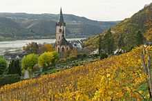
- 9 St. Hildegard Abbey. (230 m). above Eibingen with a beautiful view - the church is open, monastery shop.
- Crossing the Aulhausen - Rüdesheim road 14 Bus 187 “Youth Hostel” from the “Rüdesheim” train station. Sometimes the bus only runs as an on-call bus and must be registered up to 90 minutes before departure: 06124 - 726 5913
- 4 Gasthaus Rebenhaus. (280 m).
- Rüdesheim cable car mountain station
- 10 Niederwaldtempel. (300 m).
- 11 Niederwald Monument. (300 m). View of Bingen and the Rhine - descent to Rüdesheim and the train station.

.jpg/321px-Abtei_St._Hildegard_(Eibingen).jpg)

Upper stages Middle Rhine Valley
It starts at the Niederwald Monument Middle Rhine Valley with its many castles, and yet you stay until Lorchhausen in the Rheingau wine-growing region. The climbs become steeper and it goes down again to every wine village. But you can also take the mostly lower-lying hiking trails Hessenweg 7 or the Rhein-Riesling-path up to Chew hike.
Niederwald monument near Rüdesheim - Assmannshausen - Lorch: 20.4 km
5th stage: Distance: 20.4 km, ascent: 719 m, descent: 933 m, duration: 6:30 h, highest point: 334 m (Jagdschloss) and 350 m (Teufelskadrich)
Niederwald Monument near Rüdesheim - Assmannshausen: 5.9 km

Through the Niederwald to Assmannshausen
From the Niederwalddenkmal it first goes downhill and before the magic cave uphill.
- 12 Rossel castle ruins. (built around 1794).
- 9 Knight hall
- 13 Magic cave
- 5 Niederwald hunting lodge and game reserve. (334 m). Niederwald hunting lodge and game reserve (334 m) - from here it goes steeply downhill to the Assmannhausen district. A chairlift also leads from the Niederwald hunting lodge to Assmannshausen.
- Assmannshausen Town center
- 14 Holy Cross Church
- 6 Old farmer's tavern
Assmannshausen - Lorch: 14.5 km

- Railway stations in Assmannshausen and Lorch (RMV tariff)
- Bus 187 from Assmannshausen to Aulhausen for the inefficient.
On a long ascent, it goes over serpentines through the vineyard to the red wine arbor. The access route on evenly rising concrete paths is easier, always with a view of Assmannshausen and Rheinstein Castle on the other side of the Rhine. At the northern end of the vineyard area, the now narrow rock path for 1.1 km becomes a small climbing section through the wooded and rocky Teufelskadrich slope.
- 10 Lookout point Red wine arbor (220 m) above Assmannshausen with a view of Rheinstein Castle. There is a little wooden house by the stone wall in which bottles of wine at € 9 each and water at € 1 await the thirsty hiker. Glasses are also available.
- Teufelskadrich (Rheinsteig at 230-350m) - rocky slope and nature reserve, the mountain top of which is 416 m high.
- Gerhard Simons Hut in the Bodental
- 7 Weinhaus Free State Bottleneck
- While the Rheinsteig mainly goes through the forest, the somewhat lower Hessenweg 7 mostly goes through the vineyards with a clear view.
- Steinberg
- 11 View of Sooneck Castle
- Lorch
- Parish Church of St. Martin
- 15 Market with half-timbered town hall and Robert Struppmann Museum
- → 16 Hilchenhaus with tourist information
- Wisper Bridge
Lorch - Lorchhausen - Chew: 13.4 km

6th stage: Ascent: 787 m, descent: 780 m
- The 15 Lorch station is located at the southeast end of the village.
- This is where the 16 Car ferry Lorch ↔ Niederheimbach at.
- From 17 Lorchhausen station there is a narrow one from Kauber Strasse Access to the Wirbellay lookout point. From the Oberfelcken valley road, you come across the Rheinsteig above the König winery.
- 17 Lorch, Wisper Bridge
- From the street Weiselberg, the Rheinsteig branches off to the left and then goes sharply left and steeply upwards from the next branch. Surefootedness is expected, but the rock path to the castle ruins is secured with ropes. The two alternative routes initially continue straight ahead.
- 18 Nollig castle ruins. Former watchtower (176 m, no visit possible) - rest area and beautiful view of Lorch, as well as on the way to Lorchhausen.
- 12 Lookout point on Lorchhausen
- 19 Clemenskapelle (below the Rheinsteig and above Lorchhausen)
- Retzbachtal - road to Lorchhausen (train station). The wide Rheinsteigweg slowly goes uphill again.
- 13 Viewpoint "Panoramablick" on Lorchhausen
- 14 Wirbellay - view over the Rhine Bacharach
- 15 Viewpoint on Kaub
- 16 Viewpoint on Kaub
- Niedertal
 View of Pfalzgrafenstein Castle near Kaub
- 2 Wine stand and snack with venison sausage from the charcoal grill, in the middle of the forest.
- Grenzvogt (Gate of the Free State of Bottleneck) - Narrowest point of the Free State, which existed between 1919 and 1923. Today you cross the border from Hesse to Rhineland-Palatinate here. From here it goes steeply uphill on a path.
- 17 Forest clearing with a view of the Rhine and Kaub ,
- 18 Turn right to Kaub on Hessenweg with abbreviation.
- Volkenbachtal
- 20 Gutenfels Castle
- 21 Chew - Blücher monument and ferry pier.

Alternative ways
- Rheingau Riesling Path
- Hessenweg 7
Kaub - Loreley − St. Goarshausen: 22 km


7th stage: Difficulty: difficult, ascent: 801 m, descent: 781 m, duration: 7:00 h, highest point: 345 m (Dörscheider Heide)
From St. Goarshausen train station or the ferry from St. Goar with the (Good Friday - October) to the Loreley. From the "Rheinfähre" bus line 559 goes to "Loreley Abzweig".
- Chew
- Dörscheid
- 18 Rossstein. (210 m).
- 22 Old castle. (235 m).
- Urbachtal
- 19 Lookout temple at the forest school. (210 m).
- Bornichbachtal
- Five lake place
- 20 Block Loreley
- 21 Rock pulpit. (160 m).
- 22 Spitznack
- 23 Observation pavilion. (140 m).
- Wine trail
- 24 Loreley
- → Round tour Loreley extra tour - Difficult route: 14.8 km, ascent and descent: 515 m, duration: 4:15 h, highest point: 299 m
- Heath (250 m)
- 23 Katz Castle. Neukatzenelnbogen Castle.
- St. Goarshausen Forstbachtal, Burgstrasse
- 25 Three castle view. (160 m).
- St. Goarshausen Hasenbachtal, Nastätter Strasse


St. Goarshausen - Kestert: 7.7 miles

8th stage: Difficulty: medium, ascent: 690 m, descent: 603 m, duration: 4:00 h, highest point: 281 m (Sachsenhausen field)
- St. Goarshausen Hasenbachtal
- 26 Looking back at Katz Castle
- → 27 Rabenacksteig - 500 m long via ferrata to the Rebenack ledge. It goes down from 175 m in height to 110 m. From here you have a wonderful view of the valley and of Rheinfels Castle on the left bank of the Rhine.
- Hiking car park Nocherner Brünnchen
- 24 Mouse Castle
- Wellmich - Heumarktspfortermühle
- Mining educational trail
- Sachsenhausen field
- Spoil dump
- Pulsbachtal
- Oberkestert
- Kestert
Kestert - Filsen: 14.1 km
9th stage: Difficulty: difficult, ascent: 484 m, descent: 438 m, duration: 4:00 h, highest point: 365 m (Lykershausen)
- Kestert
- 28 Hindenburghöhe viewpoint
- Lykershausen
- 29 Brömserkopf lookout point
- 25 Liebenstein Castle
- 26 Sterrenberg Castle
- Kamp-Bornhofen, confluence with the wine trail
- Filsener Lei
- Filsen

Filsen - Braubach: 13.1 km
10th stage: ascent: 776 m, descent: 787 m, highest point 224 m
- Filsen
- Osterspai
- Old Ellig
- Witches' heads
- Pilgrimage
- Wasenbachtal
- Dinkholder Bachtal
- Pleasure house
- Zecherweg
- Marksburg
- Braubach
Braubach - Niederlahnstein: 8.3 km
11th stage: Difficulty: medium, ascent: 383 m, descent: 372 m, duration: 3:00 h, highest point: 258 m (Ernst-Wagner-Park)
- Braubach
- Dungeon plate
- In unanimity
- Lahnstein at the height − 4 Ernst Wagner Park
- The Rheinsteig does not reach Oberlahnstein or Niederlahnstein, but only the spa town of Lahnstein on the height. This consists of a clinic, a large hotel and a small spa park. From here it goes down to the Friedland district, which is down on the Lahn.
- → Access to 27 Lahneck Castle and the district of Oberlahnstein. The accompanying Lahnhöhenweg leads from the castle down to the Lahn. You reach Niederlahnstein via the Rudi Geil bridge. It is located directly on the banks of the Lahn there 28 Tavern on the Lahn.
- Lahn Bridge and Old Hohenrhein Lock
- Bäderstrasse B 260
- → Niederlahnstein

Niederlahnstein - Ruppertsklamm - Koblenz-Ehrenbreitstein: 8 miles

12th stage: Difficulty: difficult, distance: 12.8 km, ascent: 463 m, descent: 466 m, duration: 4:30 h, highest point: 321 m (Lichterkopf)
- → Niederlahnstein, on Bäderstraße B 260 in the direction of Bad Ems
- Ruppertsklamm
- Light head
- Dornswiese
- Awake-up head
- Bienhorn Valley
- Koblenz-Pfaffendorf
- Koblenz-Ehrenbreitstein
Alternative routes
- Follow the foot and bike path from Braubach am Rhein Oberlahnstein. From there the access path to the Lahnstein spa park on the height.
- From Braubach am Rhein take the foot and cycle path to the mouth of the Lahn on the Niederlahnsteiner side and along the Lahn along the access path to the Ruppertsklamm. Attention, from Oberlahnstein the further riverside path leads to the confluence of the Lahn into the Rhine, but it is a dead end, as the industrial port is parallel, therefore run through the village and over the Lahn bridge.
Lower stages Middle Rhine Valley
Koblenz-Ehrenbreitstein - Vallendar: 9.1 km
13th stage: Difficulty: easy, ascent: 284 m, descent: 269 m, duration: 2:55 h, highest point: 189 m (Ehrenbreitstein Fortress)
- Koblenz-Ehrenbreitstein Rheinufer
- 29 Ehrenbreitstein Fortress
- 1 youth hostel
- 30 State Museum
- Arable
- Vallendar


Vallendar - Sayn: 7.7 miles
14th stage: Difficulty: medium, ascent: 454 m, descent: 456 m, duration: 4:00 h, highest point: 257 m (Römerturm)
- Vallendar
- Meerbach
- Desert farm
- Snitch grinder
- Limes Street
- Großbachtal
- Meisenhof
- Roman tower on the powder mountain
- Brexbach Valley
- Oskarhöhe
- Sayn Castle
Sayn - Rengsdorf: 15.4 km
15th stage: Difficulty: medium, ascent: 610 m, descent: 381 m, duration: 3:30 h, highest point: 306 m (Rengsdorf)
- Sayn Castle Park
- Bismarckhöhe
- zoo Neuwied
- Kuckuckberg
- Bird path
- Snipe pond
- House on the mushroom
- Aubachtal
- Swan pond
- Roman tower
- Rengsdorf

Rengsdorf - Leutesdorf: 18.5 km
16th stage: Difficulty: difficult, ascent: 479 m, descent: 610 m, duration: 6:00 h, highest point: 315 m (Schauinsland).
- Rengsdorf
- Völkerwiesenbachtal
- Chapel of St. Castor
- Roman moat
- Laubachtal
- Alm view
- Laubachsmühle
- Altwied
- Feldkirchen
- Hüllenberger stumbling block
- Leutesdorf
Leutesdorf - Bad Hönningen: 16.2 km
17th stage: Difficulty: medium, ascent: 652 m, descent: 725 m, duration: 5:30 h, highest point: 251 m (Rheinbrohler Ley)
- Leutesdorf
- Edmund Hut
- Mühlbachtal
- Hammerstein ruin
- Oberhammerstein
- Towpath
- Niederhammerstein
- Rheinbrohler Ley
- Rheinbrohl
- Bahlsbachtal
- Roman world
- Bad Hönningen
Bad Hönningen - Linz: 13.7 km

18th stage: Difficulty: medium, ascent: 474 m, descent: 497 m, duration: 4:30 h, highest point: 187 m (Kolpinghütte)
- Bad Hönningen
- Staierbachtal
- Arenfels Castle
- Ariendorf
- Helle-Au
- Leubsdorf
- Giersberg
- Dattenberg
- Kaiserberg Stadium
- Donatus Chapel
- Linz on the Rhine
Stages in Siebengebirge
Linz - Uncle − Bad Honnef: 17.9 km
19th stage: Difficulty: difficult, ascent: 662 m, descent: 605 m, duration: 6:00 h, highest point: 311 m (Eye of God)
- 31 Linz am Rhein - market square in the old town
- 32 Ockenfels Castle
- Ockenfelser Bachtal
- Kasbach
- 30 Erpeler Ley
- Stux
- Hahnerbachtal
- Uncle
- Hahnerbachtal
- Bruchhauser Heide campsite
- Breitbachtal
- 5 Eye of God (305.8 m)
- Border of Rhineland-Palatinate and North Rhine-Westphalia
- Barbara hut and branch to 6 Leyberg (359 m)
- Mucherwiesental
- Bad Honnef-Bulge
Bad Honnef - Drachenfels: 14.0 km
20th stage: Difficulty: medium, ascent: 624 m, descent: 542 m, duration: 4:00 h, highest point: 362 m (Löwenburger Hof)
- Bad Honnef-Beuel, Am Bierenbonnen (122 m), to the city center on the Rheinhöhenweg.
- Mucher Wiesental
- → 7 Himmelrich (366.4 m)
- → Parallel path (Servatius path) over 8 Wingstberg (253 m)
- Schmelztal car park
- Ohbachtal
- → 33 Löwenburg ruins (455 m)
- 8 Löwenburger Hof (360 m)
- → Parallel path over 9 Great Breiberg (312.7 m)
- → Access from Bad Honnef Light rail via Bondorf, Annatal (Moschbach) and Tretschbachtal.
- Rhöndorf, Löwenburgstraße or Dr.-Menser-Weg / Auf dem Rüdel → DB train station and city train station "Rhöndorf"
- 31 Ulanendenkmal (110 m)
- 34 Castle ruins Drachenfels (320.6 m) above Koenigswinter
- 35 Obelisk at the Drachenfels
- 19 Valley station of the Drachenfelsbahn cog railway ↔ 20 Mountain station Drachenfelsbahn - rack railway from Koenigswinter
- 36 lock Drachenburg (200 m)
- Nightingale Valley
- → Koenigswinter
- Access path to Königswinter via Eselweg, Drachenfelsstraße and 37 Nibelungenhalle, to the banks of the Rhine at the ferry terminal to Bonn-Mehlem and to the “Königswinter Fähre” tram stop.
- Access path to Königswinter (DB) train station, through the forest.
Drachenfels - Bonn: 21.4 km

21st stage: Difficulty: medium, ascent: 476 m, descent: 588 m, duration: 7:00 h, highest point: 322 m (Petersberg)
- Königswinter, Drachenfelsstraße - Nachtigallental near the Drachenburg
- Milk house
- 38 Geisberg. (323.8 m).
- Mirbesbach valley
- 39 Petersberg. (331 m).
- Fritz-Rösing-Platz
- 40 Heisterbach Monastery
- Mill Valley
- Niederdollendorf
- Rhine view
- Oberkassel
- Kuckstein
- Dornheckensee car park
- Fouveaux house
- Küdinghoven
- Rheinaue
- Passenger ferry or over the Kennedy Bridge
- Marketplace Bonn


Siebengebirge
- Leidenberg
- St. Marienberg
- Eye of God (305.8 m)
- Leyberg (359 m) NRW
- Schmelztal (140 m) - bus lines 560 and 562 "Sportplatz Scmelzbach" to Bad Honnef train station and tram 66 "Bad Honnef"
- → Löwenburg ruins (455 m)
- Oiling (329.3 m)
- Stürtzplatz
- Drachenfels (320.6 m) - castle ruins, see Koenigswinter
- Drachenburg - castle
- Geisberg (323.8 m)
- Petersberg (331 m) - Federal Government Guest House and Grand Hotel
- Heisterbach Abbey - bus line 520 "Idyllenmühle", alternative route to Oberdollendorf train station
Bonn
The Rheinsteig leads from Bonn-Küdinghoven directly to the Rhine and from Beuel over the Kennedy Bridge to the market square in the center of Bonn.
security
The Rheinsteig often leads over smaller, rocky paths - good footwear is therefore recommended. You should also have a head for heights. Pay particular attention to slippery foliage in autumn.
trips
On the way back you can see the left bank of the Rhine on the Rheinburgenweg hike.
literature
- Route planner with very detailed maps: Rheinsteig stages
Web links
- www.rheinsteig.de - official website of the Rheinsteig
- Wikipedia Rheinsteig