The Rhine Main Area is the metropolitan area in southern Hesse and, to a small extent, in Bavaria and Rhineland-Palatinate.
Regions


The Rhine-Main area is predominantly part of the large landscape Upper Rhine Plain
There is an overlap with the following landscapes:Wetterau, Hessian Ried, Mountain road, Odenwald, Taunus, Rheingau
places
There are different definitions of the size of the Rhine-Main area. Places are listed here that are within the Rhein-Main-S-Bahn network, including the eastern extension to Aschaffenburg in Lower Franconia.
- Aschaffenburg · belongs to Lower Franconia (Bavaria )
- Bad Homburg v. d. height · Am Taunus in the Hochtaunus district
- Bad Nauheim · in the Wetterau
- Bad Vilbel · in the Wetterau
- Bischofsheim
- Darmstadt and Darmstadt-Dieburg district
- Dietzenbach
- Flörsheim am Main
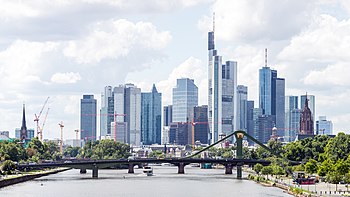
- Frankfurt am Main
- Friedberg · in the Wetterau
- Friedrichsdorf · Am Taunus
- Ginsheim-Gustavsburg
- Great Gerau · (District town) im Hessian Ried
- Hanau · in the Main-Kinzig district
- Hattersheim · on the Main river
- Hochheim am Main
- Hofheim am Taunus · Main-Taunus-Kreis
- Kelkheim · Main-Taunus district
- Kelsterbach · Between Main and airport Frankfurt located
- Königstein im Taunus
- Kronberg im Taunus
- Main valley · in the Main-Kinzig district
- Mainz · State capital of Rhineland-Palatinate in Rheinhessen
- Moerfelden-Walldorf
- Mühlheim am Main
- Neu-Isenburg
- Oberursel · Am Taunus
- Offenbach am Main
- Rodgau
- Rüsselsheim am Main · The Opel city on the Main
- Wiesbaden · Hesse's state capital in Rheingau

Other goals
- Main valley
- Rhine with the metropolitan area Mannheim
- Rheingau and Middle Rhine Valley
background
The proximity of the five large cities of Frankfurt, Offenbach, Wiesbaden, Mainz, Darmstadt and the many medium-sized and smaller cities lead to a metropolitan area of at least 2.5 million inhabitants. The metropolitan area is not clearly delimited, and some definitions include Limburg, Wetlar, Gießen and even Marburg as well as Bergstrasse and the Rhine-Hessian Worms in the south, which actually belong to the Rhine-Neckar area counting. So you get a total of 5.5 million inhabitants.
getting there
- Frankfurt am Main airport
- ICE train stations, including in Mainz, Wiesbaden, Frankfurt am Main, Frankfurt long-distance train station airport
- Cycle routes on Rhine, Main, at the Mountain road, in the valley of the Kinzig, in the Wetterau
mobility
The Rhine-Main area is well developed with nine S-Bahn lines and several regional express lines. However, there is a lack of well-developed cross-connections. The tariff area of the Rhein-Main-Verkehrsverbund (RMV) extends far beyond the Rhine-Main area and covers two thirds of Hesse and the city of Mainz.
Tourist Attractions
- Maintower in Frankfurt am Main - great panoramic view from a height of 200 m over the entire city.
- Neroberg on the outskirts of Wiesbaden
- RheinMain Regional Park - The regional park was founded by the cities and municipalities in the late 1990s. The aim was to make the open spaces between the buildings more attractive for local recreation and tourism. Numerous routes with adventure points (rest areas, works of art, visual axes, etc.) have been rebuilt in the green belts.

activities
- To go biking at the Nidda and at Main
- Visit of the Langen climbing forest
kitchen
nightlife
security
climate
The Rhine-Main area has predominantly westerly winds. The humid air masses from the Atlantic mostly rain down in the Eifel and Westerwald and on the northwest side of the Hochtaunus. In the Rhine-Main area, therefore, there is little rain. The area belongs to the warm-temperate rainy climate, which has hot summers and mild winters. In some places, palm trees and other exotic species such as B. olives, figs and much more. You can tell that the climate here is very mild: winter usually doesn't start until after Christmas, the night frosts are usually quite moderate compared to other areas of Germany. There are few ice days, in some years even none at all. Spring begins early, so daytime temperatures over 20 degrees can often be reached in March.
trips
- Taunus · With Great Feldberg, Hessenpark open-air museum, Saalburg Roman fort, Kronberg, Koenigsstein, bad Homburg
- Rheingau · With Eberbach Monastery
- Rheinhessen
- Odenwald · With the places Michelstadt and Erbach
- Mountain road