The Main cycle path accompanies the river from its two sources im Fichtel Mountains and the Franconian Switzerland through the Hatred Mountains, the Steigerwald, the Franconian wine country, the Spessart and the Rhine Main Area up to its confluence with the Rhine across from Mainz. One loop is followed by the next, so that the distance covered, measured as the crow flies, is not that great at all.
The Weißmain cycle path starts southeast of Bischofsgrün.The Rotmain cycle path starts in Cussen, goes up to the Rotmainquelle and escorts Bayreuth the young river to the confluence with the White Main west of Kulmbach.

Route profile

- Length: 498 km (Kulmbach - Mainz)
- Signposting: Good and compliant with standards. Alternatives usually do not have a logo and are therefore not part of the route.
- Slopes: largely flat valley path.
- Path condition: well-developed route, which is mostly on asphalt.
- Traffic load: largely traffic-free tour.
- Suitable bike: Everyday bike with gear shifting suitable for hills (e.g. 3, 5 or 7 gear hub) is for the Section Kulmbach - Mainz sufficient. in the Fichtel Mountains on the other hand, it is best to use a touring bike with gearshifts suitable for mountains and tread tires.
- Inline suitability: no overall information. On the lower reaches of the Main, the path is partly unpaved and partly quite narrow.
background
getting there
Public transportation
- The on Red Main lying cities Bayreuth and Cussen have rail connections on the Nuremberg - Hof route. The White Main is difficult to get to by train, with the exception of Kulmbach, where the two rivers meet. The closest train stations to the source are Marktschorgast (476 m) in the north and Willow Hill (357) in the south.
- Further railway junctions on the route are Bamberg, Wurzburg, Gemünden am Main, Aschaffenburg, Hanau, Frankfurt am Main, Mainz-Kastel and Mainz Central Station.
- Between Lohr a. Main and Wertheim there are no rail connections. The line was closed in 1979.
Tickets
- The Bayern ticket costs € 26 for 1 person and € 8 for each additional person (up to 5 people) at the DB machine, at the DB travel center € 2 more (2020). It is valid on all local trains, in the transport associations and in numerous buses, Monday to Friday from 9 a.m. to 3 a.m. the following day, on weekends and public holidays from 12 a.m. to 3 a.m. the following day. Taking bicycles with you costs an additional € 6.50 per person per day.
- With the Bayern ticket you can also travel on the Baden-Württemberg section via Wertheim – Lauda to Würzburg. At the same time, that applies Baden-Württemberg ticket also on the Bavarian route (Walldürn) / Amorbach – Miltenberg – Wertheim
- The Hessen ticket for up to 5 people and costs € 36 (2020). In both Hessian transport associations, which also includes Mainz, taking bicycles with you is free. If train tickets are used, bike tickets can be purchased for € 6.50.
- For the onward journey to Rhineland-Palatinate, you can do so from Wiesbaden or Mainz Rhineland-Palatinate ticket can be used. For 1 person € 26 and for each additional person (up to 5 people) € 6 (2020).
- The EgroNet ticket.

 in the Wikidata database") the Euregio Egrensis applies in the counties Greiz and Saale-Orla in Thuringia, in court, Kulmbach, Bayreuth, Neustadt an der Waldnaab, Pastures, Tirschenreuth and Wunsiedel in Upper Franconia, in Saxony in the Vogtland, Zwickau and the Western Ore Mountains and in Czech Republic in the region Karlovy Vary. The day pass for the second class costs 24 € (200 Kč in the Czech Republic) (plus 2 € in Germany if you buy at the counter) for the first person. For the 2nd to 5th person the additional charge is 8 € (100 Kč). You can make any number of trips with the participating transport companies on the day of validity until 3:00 a.m. the following day. In addition, you are allowed to take 3 children between 6 and 14 years and any number under 6 years with you. One bike per person is also free of charge. The surnames and first names of all travelers must be entered in block letters on the ticket, identification must be carried.
the Euregio Egrensis applies in the counties Greiz and Saale-Orla in Thuringia, in court, Kulmbach, Bayreuth, Neustadt an der Waldnaab, Pastures, Tirschenreuth and Wunsiedel in Upper Franconia, in Saxony in the Vogtland, Zwickau and the Western Ore Mountains and in Czech Republic in the region Karlovy Vary. The day pass for the second class costs 24 € (200 Kč in the Czech Republic) (plus 2 € in Germany if you buy at the counter) for the first person. For the 2nd to 5th person the additional charge is 8 € (100 Kč). You can make any number of trips with the participating transport companies on the day of validity until 3:00 a.m. the following day. In addition, you are allowed to take 3 children between 6 and 14 years and any number under 6 years with you. One bike per person is also free of charge. The surnames and first names of all travelers must be entered in block letters on the ticket, identification must be carried. - The area of validity ends in Ebensfeld, but for the source rivers and the first part of the main cycle path it is usable and cheap,
By bicycle
- White Main: Bischofsgrün · Saale cycle path, Fichtelgebirgs-Radweg, Fichtelnaab cycle path
- Red Main: Cussen · Pegnitz cycle path
The main cycle path has various connections in Bavaria and Hesse
In the street
It's easy to get back to the car's location by train. Sensible "park cities" are Aschaffenburg, Gemünden am Main, Würzburg and Bamberg.
Route description with sights

Beginners should plan 2 weeks for the Main Cycle Path. Those who are sporty simply add or triple the stages.
Source rivers:
White Main: Fichtel Mountains - Kulmbach: 51 km
More detailed description on the page Weißmain cycle path
- The 1 Source of the White Main is lying in Fichtel Mountains
 High Fichtel Mountains at an altitude of 887 m on the eastern slope of the 1024 m high Ochsenkopf. Of Bayreuth from you can take the train up to Willow Hill (357 m height) drive. From here it is another 20 km to the source, which is north of Fichtelberg lies. Cyclists have to cope with a few inclines. On the Weißmain cycle path you can then up Kulmbach cycle down.
- From May 1st to October 3rd, the Fichtelgebirge are in the Cycle buses to disposal. They leave on Sundays and public holidays Bayreuth to Karches.
This section of the route is identical to that Weißmain cycle path
- Source White Main · Km: 0 · 887 m
- Bischofsgrün in the Fichtel Mountains km 7 - 650 m above sea level NN · at the foot of the Ochsenkopf
- Gläsermühle km: 1.4 - start of the independent cycle path.
- Bad Berneck · Km: 18.5 - 387 m · Kneipp health resort
- Lanzendorf Km: 25
- Sky crown · Km: 26.8
- Neuenmarkt · Km: 32.5
- Wirsberg in the Franconian Forest km: 34 - 370 m
- Ludwigschorgast · Km: 37.8
- Untereinach Train station km: 40.3
1 Kulmbach![]()
![]()
![]()
![]() · Km: 46 - 300 m · with Plassenburg and old town
· Km: 46 - 300 m · with Plassenburg and old town

- There is one in the center of Kulmbach next to the Dr.-Stammberger-Halle (town hall) 1 Bicycle garage and changing room with 12 individual boxes for bicycles, two boxes are equipped with a battery charging station for e-bikes, there is also a changing room to change your sweaty cycling clothes and to explore the city in a relaxed way. The facility is open from April to October from 8:00 am to 10:00 pm, the cost is € 1 per bike. The tourist information is on the opposite side of the large car park and there is a public toilet at the entrance to the underground car park.
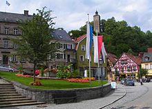
Bad Berneck market square with castle tower

Kulmbach market square
.JPG/220px-Kulmbach_Fahrradgarage_(3).JPG)
Bicycle garage inside


.JPG/220px-Kulmbach_Fahrradgarage_(3).JPG)
Red Main: Franconian Switzerland - Kulmbach
More detailed description on the page Rotmain cycle path.
- 2 Cussen
 in Franconian Switzerland with train station (ICE, IC, RE) · km 0, · 440 m altitude - already in Creußen you cross the young Red Main. It goes up 9 km to the source.
 - 2 Source of the Red Main: · Km: 8.7 · 581 m altitude - The Rote Main rises approx. 12 km south of Bayreuth and 8.5 km west of Cussen in the hill country of Franconian Switzerland. To Bayreuth gives way to the Rotmain cycle path considerably from the river. Then you accompany the river over Neudrossenfeld to Kulmbach. Shortly before the confluence with the White Main, the cycle path turns to Kulmbach.
- Hague km: 11.5
- Destuben km: 17

- Bayreuth in the Fichtel Mountains km 23.5 345 m
- Heinersreuth Km: 28
- Altenplos km 31.1
- Threschenau
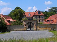
- Neudrossenfeld · Km: 34.5 - with castle and historic terrace garden, and the Brauerei-Gasthof Bräuwerk
- Altdrossenfeld - over an old stone bridge to the 1 Brewery-Gasthof Schnupp past
- 3 Unterobsang (the name comes from Absengen) with art on the bike path
- Neuenreuth Km: approx. 38 → 2 over the mountain to Thurnau, or in the valley to Melkendorf, Loop over on the railway path Thurnau and Kasendorf to Melkendorf, see description Rotmain cycle path.
- km: 40.4 - 4 Langenstadt with the beautiful church, the herb garden behind and the dancing linden tree
- Ober-Zettlitz km 45.3 - 2 Ober-Zettlitz with the Gasthaus Räther and its beer garden
- Melkendorf km: 48.3
- → 2 km detour to 3 Mainz confluence, Confluence of the White and Red Main at Steinenhausen.
- → 2 km detour to the center of Kulmbach on the street: Hauptstrasse, Melkendorfer Strasse, Wilhelm Meußdoerffer Strasse, Pestalozzi Strasse, Kressenstein.
- Branch Weißmain cycle path at the railway bridge km: 50.3

The bridge at the Mainz confluence
Steinenhausen


Main route Main:
Kulmbach - Bamberg: 78 km on Obermain

- Kulmbach at the foot of the Franconian Forest Km 0 - 300 m - 4 Kulmbach market square Capital of beer francs?
The 1 Kieswasch, the Kulmbach bathing lake, is on the way, you can swim or enjoy a cool drink at the kiosk.
- Mainleus km 6 - 306 m - 2 Mainleus open-air swimming pool directly on the bike path invites you to cool off
If you are not afraid of the mountain (a few hundred meters up, after the outdoor pool), you can visit the 1 Gasthaus Zur Linde Wilmersreuth after Wilmersreuth stop off or stay overnight.
- Fassoldshof / Mainroth - with the 3 Butchery-Gasthof Vonbrunn
- Mainroth - with the 4 Gasthof Krone
- 5 Mainklein
- Maineck - not directly on the bike path, with his 5 Maineck Castle
- Theisau
The cycle path ends in the industrial area In der Au, continue to the B 289, turn right to Burgkunstadt, left to Altenkunstadt, the path goes over the Main.
- Burgkunstadt · Km 16 - 288 m - with worth seeing 6 Burgkunstadt market square
- Altenkunstadt · Km 17 - 288 m · German Shoemaker Museum; the 5 Nepomuk Cult pub with beer garden Nepomuk is on the bike path.
- 6 Strössendorf with a castle and church that are well worth seeing
- Burgstall
- Hochstadt am Main - Be careful when crossing the federal road, continue on 3 Grubener way at the station
- 7 Confluence of the Rodach and Main rivers
- → → A detour to 7 Marketers with its half-timbered houses that are well worth seeing.
- 8 Oath with its half-timbered houses that are well worth seeing
- The 8 Rudufersee invites you to cool off
- Michelau in Upper Franconia Km 29 - 274 m 9 German basket museum
- Lichtenfels · Km 43 - 276 m · the path leads over the 10 Lichtenfels market square
- Basic field
- → → 11 Pilgrimage Church of Vierzehnheiligen - is a little off the route, a detour is worthwhile, but there are a few vertical meters to overcome. After visiting the basilica, you can fortify yourself in the brewery.
- Or along the Main via Reundorf * Schönbrunn
- Bad Staffelstein · Km 43 - 263 m · the path leads directly past the Obermain Therme. To the 9 Bad Staffelstein town center through the underpass at the train station and then along Bahnhofstrasse.
- → Connection to the Werra-Obermain cycle path

- The 12 Ebensfeld lake offers the opportunity to swim
- Ebensfeld · Km 50 - 250 m - the 6 Brewery-Gasthof Schwan has warm meals throughout
- Zapfendorf · Km 56- 243 m
- Rattelsdorf km 61 - 261 m
- → Baunach in the Hassbergen
- Breitengüßbach in the Upper Maintal-Coburger Land km 69 - 245 m
- Kemmern Km 70 - 236 m
- Hallstadt in Haßberge km 73 - 236 m
- 10 Bamberg in the Steigerwald · Km 78 - 250 m · much-visited historical city with many monuments and museums.
_10.JPG/350px-Altes_Rathaus_(Bamberg)_10.JPG)
Bamberg - Schweinfurt: 59 km
Between Bamberg and Haßfurt, the route largely runs alongside the B26. Then a good section with its own bike path and proximity to the Main.

- Viereth-Trunstadt Km 88 - 240m
- Eltmann Km 98 - 232m with Wallburg castle ruins
- → Ebelsbach ·
- Limbach (district of Eltmann) Pilgrimage Church of Maria Limbach
- Sand on the Main Km 104
- Zeil am Main Km 106 - 228m City center with town hall
- → Mariaburghausen Cistercian convent · Is located on the southern bank of the Main, not on the bike path.
- Hassfurt / Hatred Mountains Km 114 - 230m
- Sparings in the Franconian wine country km 132 - 211m
- Mainberg Km 133 Mainberg Castle
11 Schweinfurt![]()
![]()
![]()
![]() in the Franconian wine country km 137 - 214m Renaissance town hall, Georg Schäfer Museum, art gallery
in the Franconian wine country km 137 - 214m Renaissance town hall, Georg Schäfer Museum, art gallery

Schweinfurt - Kitzingen: 60 km
General
This section often leads on cycle paths alongside country roads. But there is only moderate traffic. But the attractive wine landscape around the Volkacher Mainschleife compensates for this.
 Main at Schweinfurt |  Maria in the vineyard in Volkach |
 City wall in Dettelbach |  Kitzingen |
- Bergrheinfeld Km 143
- Waigolshausen Km 150
- Wipfeld · Km 155 - 198m - a ferry must be used here.
- → You can stay on the north side for a few more kilometers. The route is a little quieter and closer to the Main. In Untereisenheim (currently out of service) and Drive are ferries where you have to cross over.
- 4 Main ferry at Wipfeld
- Kolitzheim km 157
- 5 Main ferry at Obereisenheim
- 6 Main ferry in Fahr am Main, a fishing and winegrowing village; the ferry is mentioned in a document as early as 1400
- Volkach Km 167 Attractive old town with excursion gastronomy and overnight accommodation.
3 km west of the city, a walk up to the church "Maria im Weingarten" (beautiful view of the Main) is worthwhile.
- → after Volkach there is an alternative signposted "via the Alleenweg" to Sommerach. It's shorter and quieter (???).
- → South of Volkach, the Volkacher Mainschleife along the Main Canal can be shortened directly to Gerlachshofen.
- Nordheim am Main · Km 172
- Sommerach · Km 177 - place is characterized by wine bars.
- Schwarzach · Km 177 - with the Münsterschwarzach Abbey
- Dettelbach Km 187
- 7 Ferry Dettelbach - Mainsondheim. Tel.: 49 171 9792296. Open: Summer timetable: Mon-Fri 6.30am - 12pm and 1pm - 7pm, Sat 7.30am - 12pm and 1pm - 6pm, on Sundays and public holidays from March 1st to October 31st 10am - 12pm and 1pm - 6pm; Winter timetable: Mon-Fri 6.30 a.m. - 12 p.m. and 1 p.m. - 7 p.m., Sat 7.30 a.m. - 12 p.m. and 1 p.m. - 6 p.m., no ferry service on Sundays and public holidays from November 1st to February 28th.Price: pedestrian / cyclist € 0.80, car / motorcycle € 1.70.
- 12 Kitzingen in the Franconian wine country km 197 - 192m - old town well worth seeing
- Detour to Iphofen via bike path From the Main to the Aisch: 9 km

Kitzingen - Wurzburg: 34 km
Quite a short stage, so that there is still time to visit Würzburg in the afternoon.
 Malerwinkelhaus in Marktbreit |  Main street in Ochsenfurt |

- Market wide · Km 206: Actually one of the most picturesque towns in the Main Triangle. Unfortunately, in contrast to Kitzingen, there is no real pedestrian zone in the narrow old town. The quality of stay in the otherwise beautiful old town is limited by the car traffic. There is also no beautiful promenade like in Kitzingen. In Marktbreit there is a. a larger parking lot directly on the Main. At least there are a few benches with a view of the Main at this parking lot (near the historic crane). Plus point for self-caterers: A supermarket (REWE) can be found in Marktbreit near the Main, directly on the route. Public toilets can be found on the corner of Marktgasse / Bachgasse (directly opposite the Malerwinkelshaus near the tourist information office).
- →→ Frickenhausen am Main
- Ochsenfurt Km 213
- → this is where the Gaubahn cycle path, which connects the Main with the Tauber.
- 8 The mermaid (Ochsenfurt old town ferry) (below the Main Bridge in Ochsenfurt). Tel.: 49(0)9331 98 45 200. Open: from May to October daily from 9 a.m. to 5 p.m.
- Sommerhausen · Km 218 the counterpart on the other side of the Main is called Winterhausen
- Eibelstadt Km 221
- Randersacker 226 km
- 13 Wurzburg in the Franconian wine country · km 231 - 175m · many sights: Residenz, cathedral, old Main bridge, Marienberg fortress, various museums

Wurzburg - Lohr am Main: 58 km
This section of the Main is densely populated and characterized by the railway and federal road 27. The ICE leaves the valley in Gemünden in the direction of Fulda, together with the D-Route 9. However, the route is close to the river and therefore not so affected by the noise. The gastronomic offer for cyclists is very rich and also cheap.
- Zell market Km 235
- → → Veitshochheim - Baroque castle with castle garden in rococo style
- Margetshöchheim Km 241
- Erlabrunn Km 244
- → → Thüngersheim
- Zellingen Km 249
- Sky city Km 253
- Karlstadt Km 260 Ruin Karlsburg
- Gemünden am Main in the Spessart-Mainland · km 275 · Scherenberg ruins, regional railway junction
- → good (better?) Alternative bike path on the right bank
- 14 Lohr am Main in the Spessart mainland · Km 289 - 165m · Kurmainzer Castle, Spessart Museum. Only once the end of the railway line to the west in the Main valley

Lohr - Wertheim - Miltenberg: 65 km

- Neustadt am Main · Km 297 - with monastery church
- Rothenfels with the castle of the same name and a beautiful view
- Marktheidenfeld Km 308
- Triefenstein in the Franconian wine country km 316 - and Triefenstein Monastery
- Homburg am Main with Hornburg Castle and the Burkardus Grotto
- 15 Wertheim in the lovely Taubertal (Baden-Württemberg) km 329 143m
Confluence of the Lovely Taubertal cycle path
Change to the right main page.

- Historic old town with city wall and many architectural monuments, imposing castle ruins, Kittstein gate, collegiate church, court holding (today town hall), angel fountain, Kilian's chapel, Marienkapelle, Spitzer tower, glass museum, county museum in the old town hall)
- Kreuzwertheim in the Spessert mainland km 332
- Stadtprozelten · Km 344 - with the ruins of Henneburg
- Village Proceedings Km 347
- Collenberg Km 354
- Kollenburg castle ruins
- → Freudenberg am Main · Km 356 - tiny historical town with castle ruins
- Cherry ford - City museum, Freudenberg castle ruins
Change to the left main page - Burgstadt Km 363 - Martinskapelle (10th century)
- 16 Miltenberg in the Spessart mainland km 365 132m - much-visited half-timbered gem (well-known half-timbered row on the market square), city gates, Würzburg tower, Mildenburg castle (castle ruins)

Miltenberg - Aschaffenburg: 41 km
- Kleinheubach (left Main) km: 369 - Löwenstein Castle
Change to the right side of the Main, an alternative route through the village and continue on the left side of the Main - Großheubach (right-Main Main) km: 371 - ascent (over 612 steps) or ascent to Engelberg Monastery worth it.

- Klingenberg (right-Main Main) km: 379 - castle ruins, Klingenberger Schlucht
Change to the left side of the Main, an alternative route via Erlenbach on the left. - Woerth am Main (left Main) · km: 382 - Old Town worth seeing
- → Erlenbach am Main
- Obernburg am Main · Km: 388 - old town behind well-preserved city wall, turn offs necessary
- → Elsenfeld
- → Kleinwallstadt (right Main) -
- Großwallstadt (left Main) km: 393
- → Sulzbach am Main (right Main)
- Niedernberg· Km: 398
- 17 Aschaffenburg · Km: 408 · 117m - change to the left side of the Main

- The "Bavarian Nice" is a nice stage destination. The old town, the park and Schönbusch Palace, Johannisburg Palace with palace gardens, the collegiate basilica of St. Peter and Alexander and the Pompejanum are all worth seeing. The city is home to interesting museums and collections.
Aschaffenburg - Frankfurt am Main: 55 km
There are continuous cycle paths on both sides of the Main between Aschaffenburg and Mainz. Only one side of the main cycle path is signposted.
- Mainaschaff
- Kleinostheim Km 415
- Dettingen (municipality of Karlstein am Main) - change to the left side of the Main to Frankfurt.
- → Karlstein am Main
- Mainhausen-Mainflingen in the Hessian Lower Main km 420
- Seligenstadt · Km 425 - historic old town with several defense towers, with monastery, monastery museum "Former Benedictine Abbey", landscape museum and carnival museum
- 9 Main ferry "City Seligenstadt". Tel.: 49 6182 87-410. Open: daily 6:00 a.m. to 8:00 p.m., Sundays and public holidays from 9:00 a.m.Price: € 0.80, € 1 bike, € 3 car.
- → Bald
- → Großkrotzenburg
- Klein Krotzenburg (district of Hainburg)
- Hainstadt (District of Hainburg) Km 431
- Klein-Auheim (district of Hanau) - after the level crossing, turn right again to the Main.
- Steinheim Castle and its museum
- Steinheim (District of Hanau)
- → Hanau · Over the railway bridge, then left into the street “Am Steinheimer Tor” into the center of the Brothers Grimm City.
- Industrial city in the eastern Rhine-Main area. The old goldsmiths, a stately half-timbered building and the castle with the castle park Philippsruhe am Main in the west of the city are well worth seeing. There are also some museums. On the BahnRadweg Hessen one arrives at the state park Wilhelmsbad with the historical spa and bathing facilities and the doll museum.

- Dietesheim (district of Mühlheim an Main) km 443 - ferry
- → Main valley
- Rumpenheim (District of Offenbach) - Castle, ferry and crossing of the Hess. Long-distance cycle route R4
- Bürgel (district of Offenbach)
- Offenbach · Km 454 - is near Frankfurt. The leather museum is worth a visit.
- 18 Frankfurt am Main · Km 460 · 99m - Over the Eiserner Steg it goes directly to the historical center with the Römerberg and Kaiserdom. · The smallest "metropolis in the world" has a lot to offer. · If you don't know the city yet, you can get a first overview from the cathedral or the main tower.


Frankfurt am Main - Mainz / Wiesbaden: 40 km
The cycle path runs between the busy Uferstraße and the Main, past the districts of Niederrad and Schwanheim, then through allotments and in sharp bends through the middle of the expressway junction B40 / B43 to over the Main Bridge at the Frankfurt Höchst industrial park. With the S-Bahn S1 you can travel at the city rate (2.20 €) via Ffm-Höchst to Sindlingen and then cycle a short distance on the industrial track to the Main.
- → → Frankfurt-Höchst with the ferry to the other side of the Main.
- 10 The Höchst Main ferry between Höchst and Schwanheim in Frankfurt am Main, it only transports people and cyclists;
- Kelsterbach · Km 472 · Change over the Main Bridge, or first take a detour at the Kelsterbacher Mainufer
- Detour to the Schwarzbach Hattersheim or in the regional park to the nature reserve Weilbacher Kiesgruben
- Okriftel (District of Hattersheim) - Passenger ferry at the weekend → to Eddersheim it continues away from the Main
- Detour from the outskirts of Eddershein past the Hattersheim waterworks to the Weilbacher Kiesgruben nature reserve: The bird world of the recultivated gravel pit landscape can be observed from several observation towers.

- Eddersheim (District of Hattersheim) - footpath over the lock
- Flörsheim am Main Km 485
- Detour to Flörsheimer Warte and Weinlaubengang, back via the nature reserve Wickerbachaue, St. Anna chapel and lime kilns in the RheinMain regional park.
- → → Detour over the Main to Rüsselsheim am Main - Factory tours in the Opel factory
- After Flörsheim you have to drive around the industrial area and the harbor. Where the first vineyards of the Rheingau start cycling by the water again.
- Hochheim · Km 492 - old town with a beautiful location above the vineyards, artistically restored half-timbered houses and medieval streets.
- → → Mainz-Gustavsburg - Detour over the Main Bridge to the Mainspitzdreieck with a view of the city of Mainz.
- 13 The confluence with the Rhine between Ginsheim-Gustavsburg and Mainz-Kostheim
- Mainz-Kastel: District of Wiesbaden km 498 · 83m - Main flows into the Rhine on the Maaraue, Reduit (part of the Mainz fortress and bulwark of the bridgehead on the right bank of the Rhine), Mainz-Kastel S-Bahn and regional train station.
End of the Main Cycle Path.
→ → 19 Mainz![]()
![]()
![]()
![]() - over the Rhine bridge: historic old town with cathedral and cozy wine bars, Gutenberg Museum. The narrow streets of the pedestrian zone invite you to stroll. There are plenty of places to stop for a break.
- over the Rhine bridge: historic old town with cathedral and cozy wine bars, Gutenberg Museum. The narrow streets of the pedestrian zone invite you to stroll. There are plenty of places to stop for a break.

Entry points
- Bad Staffelstein: Werra-Obermain cycle path
- Bamberg: Regnitz cycle path
- Wurzburg: Main-Werra cycle path
- Gemünden: D-Route-9, Rhön-Sinntal cycle path, Franconian Saale cycle path
- in Hanau: Hess. Long-distance cycle route R3: Rhine - Main - Kinzig - from the Rhön above Kinzigtal
- in Offenbach (Rumpenheim Castle), (Ferry) - Mühlheim: Hess. Long-distance cycle route R4: From Sleeping Beauty to the Nibelungs
- in Frankfurt Höchst: Green belt circular cycle path - around Frankfurt Cycle route planner
- in Frankfurt Höchst: Nidda cycle path - Regional park Niddaradweg
- in Frankfurt Höchst: Hess. Long-distance cycle route R8: Westerwald - Taunus - Bergstrasse
trips
- Over the bridge in Mainz-Kastel to the left bank of the Rhine Rhine cycle route in the direction North Sea or Worms.
- On the on the right bank of the Rhine Rhine cycle route direction Rudesheim, from Oestrich-Winkel the route is no longer signposted.
- On the Hess. Long-distance cycle route R3 to Rüdesheim over the vineyards of the Rheingau.
- In Mainz-Kostheim on the Hess. Long-distance cycle route R6 and the on the right bank of the Rhine Rhine cycle route in the direction Basel.
By train
The Main Cycle Path ends directly at the train station Mainz-Kastel, on the S-Bahn and Regional Express route Frankfurt - Wiesbaden. To the Mainz main station First it goes under the bridge on the Rhine, then always to the right and over the same bridge over the Rhine, then right again and at the turn left into the Große Bleiche and always straight ahead. Before the street rises, follow the tram tracks to the right.
GPS data
- Route profile with GPS data and Google Earth KMZ file in Bike tour wiki or on radroutenplaner.hessen.de.
References to literature and maps
- Bikeline guide "Main-Radweg" 1: 75000 - see Esterbauer publishing house
- Main cycle path. From Bayreuth to the mouth of the Rhine., Compact spiral 1: 75,000, BVA Bielefelder Verlag 2011, ISBN 978-3-87073-498-5
Web links
- Cycle tourism site on the Main Cycle Route - officially
- www.main360.de - private page with route information and pictures
- Route in the Hesse cycle route planner
- Information on the Main Cycle Route
- Tourism Association of Franconia - officially