The Fichtel Mountains lies in the northeast Bavaria. The wooded low mountain range is worth a trip both in summer and in winter. With Schneeberg (1053 m) and Ochsenkopf (1024 m) the mountains have two thousand meter peaks.

Regions

The highest mountains are in the west, while the mountains to the east take on a horseshoe shape. In the middle of this “horseshoe” extends a plateau, which is in no way inferior to the high Fichtelgebirge in terms of landscape. This results in two regions and one for political-historical reasons as well as for reasons of size (based on the number of inhabitants). Urban region:
- High Fichtel Mountains - the western part with the two thousand meter peaks; almost entirely covered with forest.
- Sechsämterland - Sechsämterland is a name from the time of the Bayreuth margraviate, but it is still often used today. The area includes the plateau and the mountain ridges in the north and south, which are somewhat lower than the high Fichtel Mountains.
The communities are in the southeast fire, Ebnath, Immenreuth and Neusorg already in the district Tirschenreuth, in the administrative district Upper Palatinate. Some northeastern foothills extend to after West Bohemia in Czech Republic.
places
The largest and / or most touristic places in the Fichtelgebirge (other places in both regions High Fichtel Mountains and Sechsämterland):

- 1 Arzberg - Located in the valley of the Röslau and dominated by the Kirchberg with the Protestant church; Nearby is the Feisnitz reservoir recreation area.
- 2 Bindlach - at the foot of the Fichtelgebirge next to Bayreuth
- 3 Bad Berneck - Kneipp spa since 1930 and Kneipp spa since 1950; Spa park with colonnades.
- 4 Bischofsgrün - a holiday resort between Ochsenkopf and Schneeberg; not far outside a summer toboggan run.
- 5 Gefrees - on the southern edge of the Münchberg plateau and directly on the border of the Fichtelgebirge nature park; Folk and meadow festival in July.
- 6 Goldkronach - small town on the western edge; previous gold and silver mining.
- 7 Church ping garden - at the southern foot of the Fichtelgebirge
- 8 Marktredwitz - Located in the southeast of the Fichtelgebirge; economic center of the district of Wunsiedel. The Egerland Museum is reminiscent of the old homeland before 1945.
- 9 Same - the city of porcelain and, after Marktredwitz, the second largest city in the Fichtelgebirge Nature Park.
- 10 Speicherersdorf - the railway village at the southern foot of the Fichtelgebirge
- 11 Willow Hill - Glass and button museum, tin figure museum and cemetery church.
- 12 Weißenstadt - is located on the 48 hectare Weißenstädter See and on the upper reaches of the Eger, which rises southwest of the city.
- 13 Wunsiedel - District town of the district of the same name; In the immediate vicinity of the city there are two outstanding sights: the Fichtelgebirgsmuseum and the Luisenburg rock labyrinth.
- 14 Zell in the Fichtel Mountains - with the source of the Saale
Other goals
Mountain tops
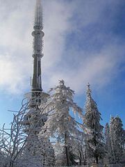
- The 1 Schneeberg.


 in the Wikidata database") (1,053 m above sea level) is the highest mountain in the Fichtelgebirge. The wooden observation tower will Ovens called. The road to the summit is closed to vehicles. The former military eavesdropping tower cannot be entered.
(1,053 m above sea level) is the highest mountain in the Fichtelgebirge. The wooden observation tower will Ovens called. The road to the summit is closed to vehicles. The former military eavesdropping tower cannot be entered.

- The 2 Ox head. (1024 m above sea level) with observation tower, Chairlift, Summer toboggan run (1000 m long with 140 m difference in altitude) and ski slopes.
- The 3 Kornberg. (827 m above sea level) with lift and ski slope.

- The 4 plate. is a 885 m high mountain in the southern Schneeberg massif. The summit is surrounded by a huge pile of angular granite slabs.

- The 5 High matzo. is a 813 m high mountain on the 50th parallel and on the watershed between the North Sea and the Black Sea. There is a summit cross on the rock formation at the summit.
.jpg/350px-Hohe_Matze_Gipfelkreuz_2018_(1).jpg)
Lakes and bodies of water
The 6 Weißenstädter See at Weißenstadt is a 48 hectare reservoir, with opportunities for swimming, sailing, surfing, fishing, etc. The lake is surrounded by a walking path. There is one open all year round campsite.
The 7 Fichtelsee![]()
![]()
![]() at Fichtelberg is an artificial reservoir with a size of around 11 ha, it is ideal for swimming, boating, walking and in winter for ice skating.
at Fichtelberg is an artificial reservoir with a size of around 11 ha, it is ideal for swimming, boating, walking and in winter for ice skating.

The 8 Förmitztalsperre![]()
![]()
![]() at Schwarzenbach on the Saale serves to raise the low water level of the Saale but is also a paradise for bathers, surfers, sailors and anglers.
at Schwarzenbach on the Saale serves to raise the low water level of the Saale but is also a paradise for bathers, surfers, sailors and anglers.
swell - The Fichtelgebirge is a European watershed. The Saxon Saale and the Eger and flow into the Elbe. The White Main, a source river of the Mains, flows into the Rhine. The Fichtelnaab and the Haidenaab flow into the Danube.
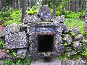
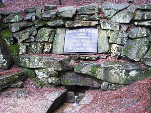
The 9 Saalequelle![]()
![]()
![]() at Cell is the source of the Saxon Saale, the Franconian Saale rises in the Rhön.
at Cell is the source of the Saxon Saale, the Franconian Saale rises in the Rhön.

The 10 Source of the White Main at Bischofsgrün at the foot of the ox head.
The 11 Egerquelle at Weißenstadt at the foot of the snow mountain.
The 12 Fichtelnaabquelle, at Fichtelberg on the southeast slope of the Ochsenkopf.
The 13 Haidenaab spring, North-east of Church ping garden.
The Weißmain spring at the foot of the Ochsenkopfs

The Fichtelnaab spring at the foot of the Ochsenkopf
Saalequelle am Waldstein at Cell

The Eger spring


background
language
Two completely different dialects meet in the Fichtelgebirge. The language border runs with deviations from southwest to northeast on the Schneeberg-Kornberg ridge. East Franconian is spoken to the west of this border and North Bavarian is spoken to the east, a dialect that belongs to the Bavarian language group.
getting there
In the street
The Fichtelgebirge lies between the motorway ![]() Nuremberg - Leipzig and the motorway
Nuremberg - Leipzig and the motorway ![]() Hof - Regensburg. Furthermore, the federal road B 303 crosses the area of Bad Berneck above Marktredwitz to Eger (Cheb).
Hof - Regensburg. Furthermore, the federal road B 303 crosses the area of Bad Berneck above Marktredwitz to Eger (Cheb).
Park
There are parking ticket machines at the cross-country skiing and hiking car parks around the Ochsenkopf. For € 2 (2019) you can park for 24 hours, also in various paid parking spaces. There is also a season ticket for € 20 and an annual ticket for € 30, which you can buy directly at the cable cars at Ochsenkopf Tel. 49 9276 644. The parking fees are used for clearing and scattering services, the preparation of cross-country ski trails and winter hiking trails, etc. Complaints and Questions to fairparken GmbH, Tel. 49 211 - 96082630 or e-mail: [email protected]
By train
With the train the Fichtelgebirge is among other things from court or Marktredwitz can be reached directly.
- The EgroNet ticket. the Euregio Egrensis applies in the counties Greiz and Saale-Orla in Thuringia, in court, Kulmbach, Bayreuth, Neustadt an der Waldnaab, Pastures, Tirschenreuth and Wunsiedel in Upper Franconia, in Saxony in the Vogtland, Zwickau and the Western Ore Mountains and in Czech Republic in the region Karlovy Vary. The day pass for the second class costs 24 € (200 Kč in the Czech Republic) (plus 2 € in Germany if you buy at the counter) for the first person. For the 2nd to 5th person the additional charge is 8 € (100 Kč). You can make any number of trips with the participating transport companies on the day of validity until 3:00 a.m. the following day. In addition, you are allowed to take 3 children between 6 and 14 years and any number under 6 years with you. One bike per person is also free of charge. The surnames and first names of all travelers must be entered in block letters on the ticket, identification must be carried.
By plane
The closest international airport is the Nuremberg Airport![]()
![]()
![]()
![]() (IATA: NUE), about 2 hours away.
(IATA: NUE), about 2 hours away.

mobility
From May 1st to October 3rd, the Fichtelgebirge were in the Cycle buses to disposal. They run on Saturdays, Sundays and public holidays.
Tourist Attractions
nature
- 14 Luisenburg rock labyrinth - A rock maze made of granite blocks (entrance fee). Festivals are held on the natural stage in summer. Also worth seeing is the Mariannenburg ruin, an artificial castle ruin with a viewpoint. The "Luisenburg-Kreuz" viewing platform is also worth climbing: the granite cliff that can be walked on even has a summit cross.
- The 1 Twelve summit view is north of Röslau on the road to Dürnberg. The granite boulder made of Kosseine granite with an octagonal stone slab is located on a 602 m high vantage point. It offers a view of the town of Röslau and, in good weather, a panoramic view of a dozen mountains in the Fichtelgebirge: Waldstein, Rudolfstein, Schneeberg, Nußhardt, Seehügel, Platte, Hohe Matze, Kosseine, Haberstein, Burgstein, Kornberg, Epprechtstein.
- 15 The square one Granite maze has five passageways and an area of 34 x 34 meters and forms the end of the quarry circular hiking trail
- 16 Rocking stone Both Gypsy stones on the west slope of the Kornberg there is a group of granite rocks where the wool sack weathering can be seen well. The so-called Rocking stone you can use a tree trunk and a bit of strength to set it in motion and make it shake.

Luisenburg rock labyrinth

The granite maze at Kirchenlamitz
.JPG/338px-Kornberg_Zigeunersteine_Wackelstein_(2).JPG)
The rocking stone can be made to rock with a tree trunk


.JPG/338px-Kornberg_Zigeunersteine_Wackelstein_(2).JPG)
- The ridge of the KitchenetteFrom the two peaks of the "Kosseine" (945 m and 922 m high) you have a great view of the surrounding landscape. There are Summit gastronomy for a strengthening. Worth seeing is the 879 m high castle stone, a lookout point on the rock of the same name.
- Rock formations at Waldstein, like the Rondell or the Whale and the viewing pavilion bowl

Large Waldstein, viewing pavilion bowl
.jpg/300px-Rondell_Waldstein_2021_(2).jpg)
The roundabout

The whale from Waldstein

.jpg/300px-Rondell_Waldstein_2021_(2).jpg)

ruins
- 17 Epprechtstein Castle ruins on the mountain of the same name
- 18 Rotes Schloss castle ruins on the Waldstein

The ruins of Epprechtstein Castle

Rotes Schloss castle ruins


Museums
- Forest Museum Mehlmeisel, at the Bayreuth House, April 1st - November 1st, Tue - Sun 10 a.m. - 5 p.m.
activities
Winter sports
Winter hiking trails are marked with yellow signs. Some of them run right next to the cross-country trails, neither the groomed nor the groomed trails, everyone has their own area! Do not leave the signposted hiking trails. Frightened wild animals are forced to use unnecessary energy when fleeing, which can mean death for animals at this time of the year.
Alpine skiing
Ski area on the Ochsenkopf with two chairlifts. There are two easy runs with a total length of approx. 3.5 km. The longest slope is 2300 m long. Snow cannons are available. further information: www.seilbahn-ochsenkopf.de
Ski lifts:
- Oberwarmensteinach, the Skischaukel Hempelsberg and Geiersberg offers two drag lifts, Geiersberg lift 450 m long, Hempelsberg lift 600 m long
- Königsheidelift Warmensteinach, further information: Tel .: 49 9277 15 21
- Klausen lifts in Mehlmeisel - 700 m long snow-covered slope, which is between 650 and 815 m high.
- New construction of the ski lift
- Bleaml Alm in new building
- Kornberg with two slopes, each 700 m long, as well as a practice slope with 130 m length for the slope report, are available on the Internet or at 49 09 287 2225
- Klingelbrunnen lift near Arzberg, drag lift with floodlights, slope length 200 m, slope width 100 m, height difference 50 m, snow telephone 49 9233 9700
Nordic skiing
There are many circular and connecting trails, see below for more information Nordic-parc.de.
- Night trails: Bleaml Alm (Neubau / Fichtelberg), Wagenthal (Warmensteinach) and Kornbachtal trail (Kornbach / Gefrees) are illuminated until 9 p.m.
- Offers snowshoeing Klaus Huebsch, Schlossstrasse 8, 95448 Bayreuth, Tel. 49 (0) 921/9900687 or 0160/99834768. Hikes of various lengths are offered, and snowshoes are provided.
- For winter sports map, see section literature.

Departure at the Ochsenkopf

Cross-country skiing on the trail

A variety of hiking trails


summer
- Déval karting, with karts down the slopes. In Oberwarmensteinach at the Geiersberglift (www.skilifte-devalkartbahn.de)
- Downhill - mountain biking, Downhill route with wooden crossings and north shore jump on the Ochsenkopf. The bikes can be taken up with the cable car (www.fichtlride.de, www.lettenbrueder.com).
- Bike rental and test bikes in Bullhead House, Fleckl 13, 95485 Warmensteinach, phone: 49 (0) 9277-975379
- Luisenburg with natural stage and open-air festival as well as the "rock labyrinth"
hike
- The Höhen- und Steinwaldweg leads over 77 kilometers over the most important mountain peaks of the Fichtelgebirge, through the Pen country and the Stone forest. The trail begins in Schwarzenbach on the Saale and ends in Waldsassen. More information under www.wanderbaren-deutschland.de
- The Lake path goes over 150 km from Steinbach am Wald in the Franconian Forest until after Speicherersdorf at the foot of the Fichtelgebirge.
kitchen
There are fewer inns, especially in the small villages. The opening times will also be reduced and there will be more days of rest. If you are planning a stop, especially when hiking, you should call in advance whether there is open and if there is space. It is advisable to reserve a table in good time, especially on Sunday lunchtimes.
Around 1647 began in nearby Pilgramsreuth, a district of Rehau, Farmers with the cultivation of potatoes. This is the earliest known potato cultivation in Germany, and that in dialect too Potatoes to be named. Even today the potato eaten with pleasure and in many variations, which grows particularly well on the barren soils.
A new trend in the Fichtelgebirge is that Wild herb cuisine, a group of Cooks has set itself the task of incorporating local wild herbs into their dishes and thus creating new taste experiences.
The diaphragm is called in the kitchen Crown meat designated. The coarse-grained, dry muscle meat, mostly from beef, is eaten with bread, herb butter and horseradish in the Fichtelgebirge. Landlords in the localities Arzberg, Thierstein, Thiersheim, Hohenberg, Höchstädt and Schirnding have teamed up and bid regularly Crown meat meals at.
With the slaughter bowl, the kettle body is called Schipf or Schüpf.
The Fichtelgebirgs-Pumpernickel are oblong shaped gingerbread cookies with a sugar coating. They have been widespread in and around Marktredwitz since well before 1800.
Six-seed ham is placed in a spice mixture, six-seed herbs and six-seed drops for about 6 weeks and then smoked with beech wood for 1 week. He is from the 1 Reichel butcher's shop made in Bad Alexandersbad.
The known Six seed drops come from the Sechsämterland in the middle of the Fichtel Mountains. The liqueur is produced in Wunsiedel.
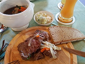
Crown meat in the root stock. Garlic butter, grated horseradish and chopped onions are served as a side dish, and bread is eaten with it. The crown meat can be ordered medium or drawn. The root brew is spooned at the end.

Fichtelgebirgs-Pumpernickel
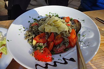
Wild herb kitchen nettle noodles


accommodation
.jpg/250px-Kösseinehaus_(Juli_2013).jpg)
The Fichtelgebirgsverein provides accommodation, from mattress dormitories to single rooms, also for non-members. Pre-registration is strongly recommended. The company holidays are in November and December, so you should check whether it is open before visiting.
security
In regularly published police statistics, Upper Franconia is shown as the administrative district in Bavaria with the fewest criminal offenses per inhabitant. In terms of security, Bavaria is one of the leaders in the national average.
Parts of the Fichtelgebirge lie in the area close to the Czech border, where the so-called veil manhunt takes place in the hinterland after the border controls have been discontinued.
In the mountains themselves, she cares Mountain Rescue for safety for hikers and skiers. BRK Bergwacht, Tel. 49 9276 352, Mountain Rescue Section Fichtelgebirge, Tel. 49 9276 91090
health

Dialysis centers
- Hohe Warte Hospital, Bayreuth, 49 (0) 921 24082
- Dialysis Center Bayreuth, Spitzwegstr. 55, 49 (0) 921 507202-0
- Bad Alexandersbad, 49 (0) 9232 99370
- Marktredwitz Hospital, 49 (0) 9231 809277
climate
The high position of the Fichtelgebirge brings a rough mountain climate with it. In the higher parts, the first ripening begins at the end of August, and snow often falls by the end of September. It rarely melts away from the fields before the beginning of May, and snowdrifts are likely to remain in the forest and between the rocky cliffs until the end of June. Night frosts sometimes set in around Midsummer. Only August and September bring beautiful, warm days. With the abundance of forests and swamps in the mountains, frequent mists rise: they envelop the mountain peaks, then they announce rain.
literature

- : Along the Bavarian-Bohemian border. Self-published by the FGV, Series of publications by the Fichtelgebirge Association "Our Fichtelgebirge", P. 128. The book is available from the FGV main office in Wunsiedel, Theresienstrasse 2, or from bookshops. Price: € 14.50
- : Fichtel Mountains. Berlin: Trescher Verlag, 2020, ISBN 978-3-89794-4732 , P. 216. Suggestions for excursions, hikes, bike tours
- ; Oliver van Essenberg (Ed.): Enjoy the way of life - in the Fichtel Mountains: Eating, drinking, going out - furnishings, design, architecture - art, culture, nature. select, 2014, ISBN 978-3981379969 , P. 304.
- : Natural wonders in the Fichtel Mountains - the treasure on our doorstep. Partenstein: Self-published by Frank Schröpfer, 2019, P. 285. Extensive representation of the animal world in the Fichtelgebirge. Order address: frank@schröpfer-net.de, price: 29 €
Hiking maps
- Fichtelgebirge Nature Park and Steinwald Nature Park. Hiking map. With tourist. Notes, colored path markings and parking spaces for hikers. Official hiking tour. d. Fichtelgebirgsverein u. D. Fichtelgebirge Nature Park 1: 50,000 16th edition. Fritsch Landkarten-Verlag Hof (Fritsch Karten: No. 52) undated, ISBN 3-86116-052-8
- Kompass hiking and biking map 191 "Fichtelgebirge", Scale 1: 50000, 6.95 euros, ISBN 978-3-85491-196-8 see also www.kompass.at
- : Special topographic maps of Bavaria. Special sheet sections based on the official topographic maps, mostly larger map formats with… cycle paths, UTM grid for GPS (UK 50-12) - western part. State Office for Surveying and Geoinformation Bavaria, ISBN 978-3860384480 .
- : Special topographic maps of Bavaria. Special sheet sections based on the official topographical maps, mostly larger map formats with… cycle paths, UTM grid for GPS (UK 50-13) - Eastern part and Steinwald. State Office for Surveying and Geoinformation Bavaria, ISBN 978-3860384503 .
Winter sports card
- Winter sports map of the Ochsenkopf region - scale 1: 20,000 weatherproof and tearproof; ISBN 3899206851 ; 4,95 €; Publicpress publishing house
Web links
- Official website Tourismuszentrale Fichtelgebirge e. V .: www.tz-fichtelgebirge.de
- Official website Naturpark Fichtelgebirge e. V .: www.naturpark-fichtelgebirge.org
- unofficial private page: Fichtelgebirge-Oberfranken.de
- Fichtelgebirge well-being region: www.wohlfuehlregion-fichtelgebirge.de (LAG Management, Regional Management City and District Coburg GmbH)
- nordic-parc.de (Page for sporting activities of the LAG-Management Wohlfühlregion Fichtelgebirge e.V.).
- glas-im-fichtelgebirge.de: History, hiking trail, museums & companies, forest glassworks
- Fichtelgebirgsverein - The hiking club operates accommodation houses and maintains observation towers and climbing facilities
- Adventure region Fichtelgebirge - The information portal for the Fichtelgebirge region
Webcams