The Franconian Forest is a low mountain range in the northeast Bavaria. A small part lies as a continuation of the Thuringian Forest in Thuringia. This area is under Thuringian Slate Mountains treated. The area can be reached quickly via the motorway and is ideal for hiking and mountain biking. In the small towns and villages that are well worth seeing, you can find overnight accommodation and hearty snacks. On rainy days you can visit a museum or simply relax in the Bad Steben thermal baths. If you want action, book a raft trip on the Wild Rodach. In 2015 the Franconian Forest was recognized as the largest area in Germany Quality region of Wanderable Germany certified.
Regions

- Eastern Franconian Forest - this is the western part of the district of Hof with the Döbraberg and the Höllental.
- Western Franconian Forest - the middle and northern part of the Kronach district.
places
A selection of the largest and / or most touristic places in the Franconian Forest (further places in the two region pages Eastern Franconian Forest and Western Franconian Forest):
- 1 Bad Steben


 in the Wikidata database") - State bath with sources containing radium mentioned as early as 1443.
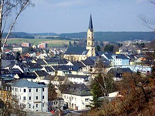
- State bath with sources containing radium mentioned as early as 1443. - 2 Helmbrechts - Upper Franconian Textile Museum.
- 3 Kronach - Largest city in the Franconian Forest, on the railway line from Lichtenfels to Saalfeld located, with the fortress Rosenberg.
- 4 Küps - is known for its high density of castles, there are eight castles for every 8,000 inhabitants in the municipality.


The pump room in Bad Steben

Helmbrechts
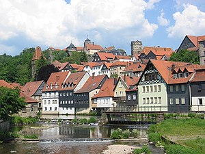
Three-tier city structure of Kronach above the Haßlach river with Rosenberg fortress

Küps


- 5 Ludwigsstadt - is located north of the mountain ridge and north of the Rennsteig hiking trail.
- 6 Naila - is on the railway line from court to Bad Steben.
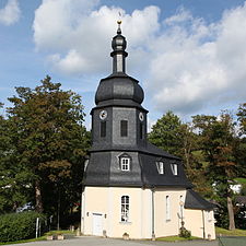
- 7 Nordhalben - is right on the border with Thuringia, the lace making is of particular tourist importance
- 8 Schwarzenbach am Wald - at the foot of the Döbraberges, the highest mountain in the Franconian Forest at 794 m.


Ludwigsstadt

Naila
_(MGK22843).jpg/338px-Jubilate_Kirche_(Nordhalben)_(MGK22843).jpg)
Nordhalben

Schwarzenbach am Wald


_(MGK22843).jpg/338px-Jubilate_Kirche_(Nordhalben)_(MGK22843).jpg)

- 9 Selbitz - like Naila on the railway line court located.
- 10 Tettau - Located at the foot of the Rennsteig.
- 11 Wallenfels - Located in the valley of the Wild Rodach; Schlossberg chapel.


Selbitz
Tettau

Wallenfels


Other goals
- The Green ribbon is a nature conservation project along the former inner-German border.
- The highest mountains in the Franconian Forest sorted by height:
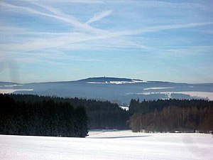
- 1 Döbraberg, 795 m, near Schwarzenbach am Wald is the highest point in the Franconian Forest, with a radome and a lookout tower.
- Schneidberg, 759 m, near Geroldsgrün
- Spitzberg, 729 m, near Bobengrün
- Stoned hill, 712 m, near Geroldsgrün
- Geuserberg, 708 m, near Geuser
- Veiteknock, 707 m, near Langenbach
- Friedelhöhe, 700 m, near Obersteben
- Langesbühl, 699 m, near Steinbach
- Knöcklein, 692 m, near Carlsgrün
- Radspitze, 678 m, near Mittelberg
- The 2 Hell Valley at Bad Steben, through which the "Röhrensteig" runs. At the end of the Hell Valley in Thuringia Blankenstein begins / ends the Rennsteig.
- The 3 Schorgasttal at Wirsberg.
- The 4 Steinachtal at Stadtsteinach.
- The valley of the Wild Rodach with their mills.
- Near Seibelsdorf, a district of Market roof is the Wheel tip at 678 meters above sea level NN, which has the highest valley-mountain difference in the entire Franconian Forest.
- The 1 Inclined plane is a steep railway line in the course of the Ludwig-Süd-Nord-Bahn from Bamberg to Hof, between the localities Neuenmarkt, Sky crown and Marktschorgast.

Döbraberg

Hell Valley

Steinach Gorge

Inclined plane


background
Large parts of the Franconian Forest, which also includes the Münchberg plateau and the Bavarian Vogtland, are protected by a 1,022 km² nature park of the same name.
getting there

By plane
The closest international airport is the 2 Nuremberg Airport![]()
![]()
![]()
![]() (IATA: NUE)
(IATA: NUE)

In the street
The motorway runs east of the Franconian Forest ![]() , in those at court
, in those at court ![]() out Chemnitz flows out. Western, already in Coburg country runs the highway
out Chemnitz flows out. Western, already in Coburg country runs the highway ![]() . There are also the federal highways B 173, B 85, B 289, B 2 and B 303.
. There are also the federal highways B 173, B 85, B 289, B 2 and B 303.
mobility
- Franconian Forest mobile is a regional bus and train network that makes it easy to do without your own car on weekends and public holidays. Buses and trains take you to many destinations, including bicycles Bad Steben, Coburg, Kulmbach, Kronach and the two MTB centers at Rennsteig and at Döbraberg. Frankenwald mobil runs from May to October. A network day ticket costs € 14 for a family, € 7 for an adult and € 2.50 for a child (as of 2020). For information on timetables and tariffs, call the service telephone number 49 9261-601516 (until Friday 12:00 noon).
- The EgroNet ticket. the Euregio Egrensis applies in the counties Greiz and Saale-Orla in Thuringia, in court, Kulmbach, Bayreuth, Neustadt an der Waldnaab, Pastures, Tirschenreuth and Wunsiedel in Upper Franconia, in Saxony in the Vogtland, Zwickau and the Western Ore Mountains and in Czech Republic in the region Karlovy Vary. The day pass for the second class costs 24 € (200 Kč in the Czech Republic) (plus 2 € in Germany if you buy at the counter) for the first person. For the 2nd to 5th person the additional charge is 8 € (100 Kč). You can make any number of trips with the participating transport companies on the day of validity until 3:00 a.m. the following day. In addition, you are allowed to take 3 children between 6 and 14 years and any number under 6 years with you. One bike per person is also free of charge. The surnames and first names of all travelers must be entered in block letters on the ticket, identification must be carried.
Tourist Attractions
- Rosenberg Fortress above Kronach
- Mantelburg at Lauenstein

Rosenberg Fortress

Lauenstein Castle


Hell Valley

The Selbitz has with Lichtenberg dug about 150 to 200 m deep into the plateau of the Franconian Forest. The road-free 4 km long valley section east of Lichtenberg is particularly worth seeing. Here the "Röhrensteig" hiking trail runs through the wooded, sometimes rugged valley. In the area of the power plant you can find various on the cliffs of the eastern slope of the valley Viewpoints (including "Hirschsprung" and "King David"). From up here you sometimes have a nice view over to the Lichtenberg Castle. By the way, the Höllentalbahn (route Blankenstein / Saale <-> Naila <-> Hof) drove through the valley. With the division of Germany during the Cold War, the railway line was interrupted on the inner-German border in Blankenstein in 1945 (for information see Wikipedia).
activities

To go biking
- There are two in the Franconian Forest MTB networks with a total of about 300 km and 8000 m elevation gain.
- The Steinach-Rodach cycle path leads from Kronach above Market roof, Rugendorf, Stadtsteinach, Untereinach until after Kulmbach.
- The Selbitz cycle path leads from the source of Selbitz to Wüstenselbitz Helmbrechts, Schauenstein, Selbitz (Upper Franconia), Naila and Bad Steben to the confluence with the Saale in Höllental.
- At frankenwald-tourismus.de a large number of bike tours are described, divided into mountain bike, racing bike and family tours.
hike
The Franconian Forest is Bavaria's first "Quality Region Wanderable Germany" There are 32 Frankenwald-Steigla designated, hikes between 5 and 18 kilometers. The near-natural paths lead past sights and refreshment stops and are uniformly and seamlessly marked. Detailed information is available at wandern-im-frankenwald.deIn the whole of the Franconian Forest, a total of 4213 kilometers of hiking are looked after by 63 local groups of the Frankewald Association. The right hiking trail can be found for every taste and every level of fitness.
- The Mühlenweg (Circular hike) leads through deeply cut valleys past eleven former mills and a hammer mill. Start is in Neumühle, 95355 Presseck, length 18 km, duration approx. 4 to 6 hours, added altitude difference approx. 600, marking: green mill wheel on a white background. A detailed description of the route can be found on the Homepage of the market Presseck.
- The Lake path goes over 150 km from Steinbach am Wald in the Franconian Forest to Speicherersdorf at the foot of the Fichtelgebirge.
rafting
Rafting played a major role in the Franconian Forest in earlier centuries. The trunks of the local forest were connected to form large rafts, over the Rodach in the Main and further into the Rhine as far as Holland. Even today you can still find many references to the past, such as the raft ponds on the upper reaches and the many weirs to dammed the water. It is also possible again to actively experience rafting on raft trips.
- From May to September take place on Saturdays on the Wilder Rodach on the approximately 5 km long route between Schnappenhammer and Wallenfels (Raftsman's house) Raft trips for tourists instead. More information about the Raft trips, at the tourist office of the city of Wallenfels. Each raft has room for around 25 to 30 people, and a total of over 500 people can take part in each raft trip.
- 5 Marktrodach rafting museum - The museum gives a comprehensive overview of rafting in the Franconian Forest.
Winter sports

Nordic skiing
There is an overview of the trails and their condition at ski-frankenwald.de
- At the Döbraberg there are 6 km, 8 km and 15 km cross-country trails and a skating trail. In any case, the start and finish point is the car park at the sports field in Döbra. The trails are well signposted.
- Walber green glacier at Grafengehaig. The floodlight system is in operation from Tuesday to Friday from 5.30 p.m. to 8.30 p.m.
Alpine skiing
There are and will be a variety of ski lifts in the Franconian Forest Ski courses offered.
- Practice area / beautiful view, Bad Steben
- Gehülz ski lift, Kronach-Gehülz
- Höfenlift, Ludwigsstadt
- Wetzellift, Ludwigsstadt
- Lauenhain ski lift, Ludwigsstadt-Lauenhain
- Ködellift, Nordhalben
- Birkholzlift Heinersreuth, Presseck-Heinersreuth
- Bergwiesenlift, Schwarzenbach am Wald
- Döbrastöckenlift, Schwarzenbach am Wald
- Small ski lift on the mountain meadow, Schwarzenbach am Wald
- Ski lift in Römersreuth, Stadtsteinach-Römersreuth
- Windheim ski lift, Steinbach am Wald - Windheim
- Pebble lift, Tettau
- Wildberg lift, Tettau
- Tettau-Langenau ski lift, Tettau-Langenau
- Haßlach ski lift, Teuschnitz-Haßlach
kitchen
There are fewer inns, especially in the small villages. The opening times will also be reduced and there will be more days of rest. If you are planning a stop, especially when hiking, you should call in advance whether there is open and if there is space. It is advisable to reserve a table in good time, especially on Sunday lunchtimes.
- 1 Chamber of nobles in Bad Steben - The noble chamber is the oldest inn in the Franconian Forest, from the 17th century. The stove is still stoked with wood and there is Franconian cuisine.
G'stopfta Rumm are a specialty that is only available in Wallenfels gives. The sour side dish to poultry or pork dishes is only available in the winter months. After the harvest, in October and November, the ingredients are chopped up into pieces the size of barley grain and then placed in layers in a barrel, salted and tamped (stuffed). After the fermentation period of several days, the "Gschtopften Rumm" are fermented like sauerkraut and can be further processed. The mixture consists of field beets, savoy cabbage, white cabbage, yellow beets and leeks. In the restaurants Egersmühle and Roseneck you can try the Rumm until around Easter. There is also the option to take a double serving home with you.
In winter and spring and on special days such as Good Friday or Ash Wednesday you can still find it from time to time Stockfish on menus.
- 2 in the Black horse in Presseck the landlord buys 150 kg of stockfish in September. From the second Sunday after Michaelis (29 September) until Ash Wednesday, if the purchased amount lasts that long, there is the stockfish with an onion and bacon cream sauce with dumplings.
- 3 in the Hildner village inn in Wallenfels Stockfish are available from January to April.

Polish with cabbage in the noble chamber
.jpg/338px-Stockfisch_Schwarzes_Ross_Presseck_(3).jpg)
Stockfish with onion and bacon cream sauce and dumplings.

.jpg/338px-Stockfisch_Schwarzes_Ross_Presseck_(3).jpg)
In Kronach do they exist Blöchla, a lard pastry that is hollow on the inside and is made in the shape of a tube with a special iron. The blocks are simply sprinkled with powdered sugar and eaten mainly during the Kerwa season.
nightlife
climate
The climate in the Franconian Forest is harsh. In summer it is always a few degrees less than in the lower areas. In winter there is usually a lot of snow that remains until spring. If it is still raining in the Main Valley in autumn, it will already start to snow in the so-called Oberland. There have been years when the summer months were frost-free.
trips
In the north lies the Thuringian Forest, in the east that Fichtel Mountains and the Hofer Land, in the south of the Obermain with the world heritage city Bamberg or the beer town Kulmbach as well as the festival city Bayreuth, in the west lies the duchy Coburg, the Hatred Mountains and the Grave field.
literature

- (Ed.): Frankenwaldverein e. V .: Hiking in the Franconian Forest. The hiking guide of the Franconian Forest Association, Ackermann Verlag, Hof ISBN 3-929364-07-7
- Richard Seuss, Hartmut Fischer: Hiking with nature and culture in the Franconian Forest. "Around the Steinachtal" (Ed.): Touristik Steinachtal
cards
- Fritsch map publisher (Ed.): No. 51 Franconian Forest Nature Park, scale 1: 50,000. ISBN 978-3-86116-051-9 . Official hiking map of the Frankenwaldverein and the Naturpark Frankenwald e.V.
- Bicycle and mountain bike map of the Franconian Forest Nature Park, Jürgen Fritsch Verlag, ISBN number 3-9806732-6-X
electronics
- Wikibooks Kronacher excursions: hikes
- Otto Knopf, Johannes Martin: The Franconian Forest - impressions of a landscape DVD, playing time 63 min, Conventus Musicus, Dettelbach 2005, ISBN 3-429-02720-9
Web links
- Frankenwald-Tourismus.de
- Frankenwald.de - Portal with a lot of tourist information
- Franconian Forest Association
- Audio guide for the Franconian Forest for mobile phone or mp3 player
- frankenwald-kulinarisch.de