
The Green ribbon is the first all-German nature conservation project and is intended to protect the area of the former inner-German border.
background
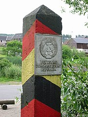
The green ribbon was created along the former German-German border strip, which, as part of the Iron Curtain, divided Europe over 12,500 kilometers and Germany over 1,393 kilometers into two blocks for almost forty years. During this period, the death strip, which was virtually inaccessible to humans, developed into a valuable refuge for animals and plants.
After the end of the Cold War, the idea arose to place the space under nature protection as a uniformly closed network over its entire length.
central area of the Green Belt is the 50 to 200 m wide corridor between the so-called Convoy path and the former German-German border. The Green Belt is the largest biotope network in Germany. There are 600 threatened species in Germany in 150 nature reserves.
Efforts are currently underway to extend the Green Belt along the entire former border line in Europe, with the patron of the former Soviet head of state Mikhail Gorbachev. Two projects that already exist, but are still being set up in some countries: The Adventure road of German unity, the international European long-distance cycle route Iron Curtain and a hiking trail run along the route.
course

It should be noted that there is no longer a continuous path directly along the line of the Green Belt. The former patrol path is no longer uninterrupted and the path along the route has to be improvised in places.
From south to north, the route lists places and attractions of tourist interest directly on the line of the Green Belt. This also includes museums on the history of the area.
Ordered from north to south:
- At Duderstadt in Lower Saxony offers that - on the Thuringian side of the former border strip Grenzlandmuseum Eichsfeld With a museum, watchtower and a preserved or reconstructed section of the border strip, detailed insights into life in particular Eichsfeld with and on the border.
- At Bad Sooden-Allendorf that is in the Werra Valley Border Museum Schifflersgrund.
Rhön
The section through the Rhön extends roughly from the Thuringian town of Geisa to the Eußenhäusener Schanz Mellrichstadt. In the northern part, the Green Belt runs on the heights east of the Ulstertal, reaching the central parts of the Rhön Biosphere Reserve with the high points at the border triangle and at Elbow and at altitudes of up to 800 mH, before the mountains of the south-eastern Rhön, which are gentler in terms of altitude, follow.
Characteristic for the Natural spaces In the high elevations of the Rhön there are the unforested mountains with a wide view, grass mats as borst grass meadows and orchid-rich grasslands, basalt block fields and raised bogs. For geology and volcanism see also the explanations in the article on Rhön.
places There is no right on the Green Belt here, localities in the vicinity are:
- On the eastern side in Southwest Thuringia: Page Geisa, Geismar, Dermbach, Kaltennordheim, Henneberg (with the Henneberg castle ruins ) and the county seat Meiningen.
- In the north part of the west side and in East Hesse in the Ulstertal: Fir, Ehrenberg With Desert saxons;
- In the south part of the west side and in Lower Franconia: Fladungen, Ostheim before the Rhön and Mellrichstadt.
The iron curtain was here for Traffic routes as good as impermeable. The Thuringian Forest Autobahn has only been connecting the cities since 1996 Schweinfurt With Erfurt and cuts through the region on the south-eastern edge, it is suitable for approaching. The Erfurt – Schweinfurt rail link has been in existence since 1993, with stops in Mellrichstadt and Meiningen, also in the southeast of the Rhön.


Worth seeing on the Green Belt is here:
- At the Tri-border area Bavaria / Hessen / Thuringia (in the immediate vicinity of the Black Moor, one of the most important raised bogs in Central Europe), there is a 17 m high new observation tower and parts of the old barriers of the border fortifications are still preserved.
- At the Elbow (official summit height 814 m, 50 ° 34 '22 "N.10 ° 4 ′ 54 ″ E), the north-eastern cornerstone of the Long Rhön, a Soviet eavesdropping system was installed from 1963 to 1970, which was operated by the GDR State Security until 1990. Today is here that Eisenach house, a modern conference hotel and the restaurant as accommodation for hikers Thuringian Rhönhäuschen.
- In and with Mellrichstadt (Lower Franconia) there is Border Museum Eußenhausen and the Cold War Documentation Center.
That follows the section of the Rhön Grave field:
Grave field

The section in the plane of the Grabfelds extends from the Schanz near Eußenhausen up to and including the "Langer Berg" nature reserve between the villages Sulzdorf an der Lederhecke and Ermershausen.
The Gäu landscape of the Grabfeld is a Keuper hill country and is mainly used for arable farming because of its favorable climatic conditions and the good soil conditions. There is grassland farming in the valley lowlands along the Franconian Saale, there are also many old orchards. They are shaped Natural spaces of the green belt in the grave field through semi-dry lime grass, fresh pastures, juniper heaths, sparse pine forests and individual smaller, semi-natural deciduous forests.

places in the immediate vicinity of the Green Belt are:
- On the Lower Franconian Side Hendungen, Rappershausen, Trappstadt, Sternberg im Grabfeld (Sternberg Castle). Nearest town is Bad Koenigshofen.
- On the South Thuringian Side the city Römhild and the place Grabfeld (municipality), a 2007 merger of 10 localities. The city is also nearby Hildburghausen.
The next Traffic routes are the federal highway B279 in the southwest and the B89 in the northeast, otherwise there are no special traffic routes here. The nearest train station is the one for the local railway in Hildburghausen.
Worth seeing on the green belt in Grabfeld is:
- German-German open air museum. various memorials and memorials on the former border itself and in the places Rappershausen, Berkach and Behrungen.
- In the Zimmerau (district of Sulzdorf an der Lederhecke) stands the Bavaria (50 ° 15 '59 "N.10 ° 35 ′ 3 ″ E): The 38 meter high observation tower was built in the immediate vicinity of the zone boundary. From above you have a wide panoramic view of the Green Belt and the surrounding low mountain range. Before the fall of the Wall it was often used as the "Ossiguck Tower" by tour groups, and much of the sight was over-interpreted.
- The "Border strip on the Galgenberg" (50 ° 22 '23 "N.10 ° 28 ′ 44 ″ E) is a two kilometer long strip of the border in Milzgrund west of Mendhausen and a Thuringian nature reserve.

- The information path "The Border Crosser" (50 ° 19 ′ 40 ″ N.10 ° 35 '54 "E) between the Lower Franconian Trappstadt and the Thuringian Schlechtsart was opened on the Day of German Unity in 2008. It leads as a 10-kilometer circular route with information boards to various points on the former border and also to a few meters of the remains of the original border fence that were forgotten by NVA soldiers during dismantling and to other relics of the former GDR border, as well as through the nature reserve near the border "Altenburg" with rare plants and birds.
Hatred Mountains
Coburg country
Bad Rodach with its thermal baths and the toy city Neustadt near Coburg lie in Coburg country, right on the former border.
Franconian Forest
The Hell Valley is a protected valley of the river Selbitz im Eastern Franconian Forest
Hofer Land
.jpg/220px-Mödlareuth_Freilichtmuseum_2016_(1).jpg)
The little village 1 Mödlareuth![]()
![]()
![]()
![]() is a specialty: a part of it is in Bavaria today and belongs to the place Pots, the other in Thuringia. The former state border of the GDR ran through the middle of the village, making Mödlareuth a “miniature Berlin”, so to speak, with everything that goes with it. Today there is a very interesting border museum here; You can see a part of the original wall, a watchtower, dog running system and military vehicles, including a Soviet tank. There is a small exhibition on the division of Germany as well as film screenings in the museum building.
is a specialty: a part of it is in Bavaria today and belongs to the place Pots, the other in Thuringia. The former state border of the GDR ran through the middle of the village, making Mödlareuth a “miniature Berlin”, so to speak, with everything that goes with it. Today there is a very interesting border museum here; You can see a part of the original wall, a watchtower, dog running system and military vehicles, including a Soviet tank. There is a small exhibition on the division of Germany as well as film screenings in the museum building.

The Tri-border area Bavaria-Saxony-Czech Republic is at Prex, a district of Regnitzlosau.
security
The entire area of the so-called "death strip" was mined for around 800 kilometers and was officially cleared, but there is a residual mine risk in sections, and mines are still washed ashore in streams after heavy rainfall.
The paths are generally considered safe. However, there is still a small risk occasionally off the beaten path, warning signs must be observed.
literature
Web links
- The green belt at www.bund-naturschutz.de
- BUND project office Green Belt: www.erlebnisgruenesband.de
- The Green Belt Germany cycle path (partly different from the Iron Curtain Trail) in Bike tour wiki.