The eastern Franconian Forest is the part of the nature park Franconian Forestwho is in the county court lies. A small part of the district of Kulmbach can also be included. The area can be reached quickly via the motorway and is ideal for hiking and mountain biking. In the small towns and villages that are well worth seeing, you can find overnight accommodation and hearty snacks. On rainy days you can visit a museum or simply relax in the Bad Steben thermal baths.
places

- 1 Bad Steben


 in the Wikidata database") - State bath with sources containing radium mentioned as early as 1444.
- State bath with sources containing radium mentioned as early as 1444. - 2 Earl mate - with the Walberngreen Glacier
- 3 Guttenberg - on the southern edge of the Franconian Forest.
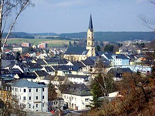
- 4 Helmbrechts - Upper Franconian Textile Museum.
- 5 Issigau - with the Hell Valley
- 6 Kupferberg - is known for its mining history
- 7 Lichtenberg - with the castle ruins and the Hell Valley


The pump room in Bad Steben

Earl mate

Helmbrechts
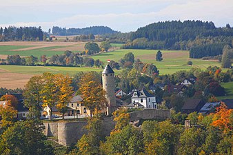
Lichtenberg


- 8 Ludwigschorgast - is on the southern edge
- 9 Marktleugast - with the Catholic, parish and pilgrimage basilica Maria Heimsuchung in the Marienweiher monastery
- 10 Marktschorgast - at the upper end of the steep railway line Schiefe Ebene, with the Goldebergsee
- 11 Naila - Located on the eastern edge of the Franconian Forest Nature Park, is the place where a GDR refugee family landed in a hot air balloon in 1979. The railway line runs via Naila from Hof to Bad Steben.
- 12 Neuenmarkt - with the steam locomotive museum


Marienweiher Basilica

Marktschorgast

Naila

Neuenmarkt


- 13 Presseck - Market between the Rodach and Steinach valleys, cross-country trails are groomed in winter
- 14 Rugendorf - at the foot of the Franconian Forest Nature Park
- 15 Schauenstein - Small town on an elevation above the Selbitztal; Castle with fire brigade museum.
- 16 Schwarzenbach am Wald - Located at the foot of the Döbraberges, the highest mountain in the Franconian Forest at 795 m.


Presseck

Rugendorf

Schauenstein

Schwarzenbach am Wald


- 17 Selbitz - like Naila on the railway line court located.
- 18 Stadtsteinach - Located at the exit of the Steinach Valley; Worth seeing, under monument protection standing place.
- 19 Stammbach - at the foot of the Weissenstein Eclogite Mountain
- 20 Untereinach- at the Steinach-Rodach cycle path and on Main cycle path located
- 21 Wirsberg - the wedding village in the south


Selbitz

Stadtsteinach

Untereinach

Wirsberg


Other goals
- The Green ribbon is a nature conservation project along the former inner-German border.
- The 795 m high 1 Döbraberg at Schwarzenbach am Wald.
- The 2 Hell Valley at Bad Steben, through which the "Röhrensteig" runs. At the end of the Hell Valley in Thuringia Blankenstein begins / ends the Rennsteig.
- The Schorgasttal at Wirsberg.
- The Steinach Gorge at Stadtsteinach.
- The 688 m high 3 Weissenstein at Stammbach with a restaurant and a lookout tower.
- The 1 Inclined plane is a steep railway line in the course of the Ludwig-Süd-Nord-Bahn from Bamberg to Hof, between the localities Neuenmarkt, Sky crown and Marktschorgast.


Döbraberg

Hell Valley

Steinach Gorge

Beer garden on the Weißenstein

Inclined plane


getting there
By plane
The closest international airport is the ![]() Nuremberg Airport (IATA: NUE)
Nuremberg Airport (IATA: NUE) ![]()
![]()
![]()

By train
The area is difficult to reach by train. There is that in the north 2 Bad Steben train station is the terminus of the railway line that is integrated into the Bayerntakt and is therefore used every hour court with stops in 3 Selbitz and 4 Naila. In the east there are the train stations in 5 Münchberg and 6 Marktschorgast. In the south you can go to the train stations in 7 Untereinach, 8 Ludwigschorgst and 9 Neuenmarkt on the railway line Bamberg - Get off the yard. In the west you will find the next train station far away in Kronach.


In the street
The runs along the edge of the eastern Franconian Forest ![]() , in those at court
, in those at court ![]() out Chemnitz flows out. There are also the federal highways
out Chemnitz flows out. There are also the federal highways ![]() court (A 9 / A 72) -Kronach,
court (A 9 / A 72) -Kronach, ![]() Münchberg (A 9) -Kulmbach and
Münchberg (A 9) -Kulmbach and ![]() Bad Berneck (A 9) -Kronach.
Bad Berneck (A 9) -Kronach.
mobility
- Franconian Forest mobile is a regional bus and train network that makes it easy to do without your own car on weekends and public holidays. Buses and trains take you to many destinations, including bicycles Bad Steben, Coburg, Kulmbach, Kronach and the two MTB centers at Rennsteig and at Döbraberg. Frankenwald mobil runs from May to October. A network day ticket costs € 14 for a family, € 7 for an adult and € 2.50 for a child (as of 2020). For information on timetables and tariffs, call the service telephone number 49 9261-601516 (until Friday 12:00 noon).
- The EgroNet ticket. the Euregio Egrensis applies in the counties Greiz and Saale-Orla in Thuringia, in court, Kulmbach, Bayreuth, Neustadt an der Waldnaab, Pastures, Tirschenreuth and Wunsiedel in Upper Franconia, in Saxony in the Vogtland, Zwickau and the Western Ore Mountains and in Czech Republic in the region Karlovy Vary. The day pass for the second class costs 24 € (200 Kč in the Czech Republic) (plus 2 € in Germany if you buy at the counter) for the first person. For the 2nd to 5th person the additional charge is 8 € (100 Kč). You can make any number of trips with the participating transport companies on the day of validity until 3:00 a.m. the following day. In addition, you are allowed to take 3 children between 6 and 14 years and any number under 6 years with you. One bike per person is also free of charge. The surnames and first names of all travelers must be entered in block letters on the ticket, identification must be carried.
Tourist Attractions

- Sanctuary Basilica 4 Marienweiher near Marktleugast, with Franciscan monastery

- Coal piles in the Thiemitztal
- The 589 meter high Magnetberg 5 Peterleinstein between Kupferberg and Marktleugast protrudes prominently from the forest. What makes the Peterleinstein special are the rare plants that can be found there. The mountain consists of greenish Serpentinite, a very basic rock on which only sparse vegetation thrives; the rock is also magnetic.

activities
summer

- The Franconian Forest is Bavaria's first Quality region of Wanderable Germany. There are 32 Frankenwald-Steigla designated, hikes between 5 and 18 kilometers. The near-natural paths lead past sights and refreshment stops and are uniformly and seamlessly marked. Detailed information is available at wandern-im-frankenwald.de. In the whole of the Franconian Forest, a total of 4213 kilometers of hiking are looked after by 63 local groups of the Frankewald Association. The right hiking trail can be found for every taste and every level of fitness.
- The Selbitz cycle path leads from the origin of Selbitz in Wüstenselbitz via Schauenstein to the confluence with the Saale in Höllental.
- Wine festival and garden fair in the castle park of those of Lark field in Heinersreuth
winter
Nordic skiing
- At the Döbraberg there are 6 km, 8 km and 15 km cross-country trails and a skating trail. The starting and finishing point is the parking lot at the sports field in Döbra. The trails are well signposted.
- Walber green glacier near Walberngrün, a district of Earl mate, between Helmbrechts and Enchenreuth. The floodlight system is in operation from Tuesday to Friday from 5.30 p.m. to 8.30 p.m.
- Walberngrüner Glacier: constantly groomed circuit; Difficulty level: easy; Length: 2.5–10 km; Starting point and car park: Walberngrün / Grafengehaig sports field; 80 meters in altitude; with floodlight system.
- Gösmes-Walberngrün: occasionally groomed circuit; Difficulty level: easy; Length: 7 km; Starting point and parking lot: Sports field in Walberngrün / Grafengehaig; 100 meters in altitude
- Gösmes-Walberngrün: occasionally groomed circuit; Difficulty level: easy; Length: 12 km; Starting point and parking lot: Sports field in Walberngrün / Grafengehaig; 150 meters in altitude
Alpine skiing
- The baron of Lark field operates the Birkholzlift near Heinersreuth a district of in winter Presseck with 3 runs with a length of 500 to 800 m and a width of 60 m with a height difference of 95 m.
kitchen
There are fewer inns, especially in the small villages. The opening times are also being reduced and there are more days of rest. If you are planning a stop, especially when hiking, you should call in advance whether there is open and if there is space. It is advisable to reserve a table in good time, especially on Sunday lunchtimes.
Gastronomic destinations away from the villages:
- 1 Bischofsmühle, Excursion restaurant only accessible via gravel paths, good starting point for hikes (95233 Helmbrechts). Tel.: 49 (0)9289 367, Fax: (0)9289 970791, Email: [email protected]. Open: Open Wednesday to Sunday.
- 2 Chamber of nobles in Bad Steben - The noble chamber is the oldest inn in the Franconian Forest, from the 17th century. The stove is still stoked with wood and there is Franconian cuisine.
G'stopfta Rumm are a specialty that is only available in Wallenfels gives. The sour side dish to poultry or pork dishes is only available in the winter months. After the harvest time, in October and November, the ingredients are chopped up into pieces the size of barley grain and then placed in layers in a barrel, salted and tamped (stuffed). After the fermentation period of several days, the "Gschtopften Rumm" are fermented like sauerkraut and can be further processed. The mixture consists of field beets, savoy cabbage, white cabbage, yellow beets and leeks. In the restaurants Egersmühle and Roseneck you can try the Rumm until around Easter. There is also the option to take a double serving home with you.
In winter and spring and on special days such as Good Friday or Ash Wednesday you can still find it from time to time Stockfish on menus.
- 3 in the Black horse in Presseck the landlord buys 150 kg of stockfish in September. From the second Sunday after Michaelis (September 29th) until Ash Wednesday, if the purchased amount lasts that long, there is the stockfish with an onion and bacon cream sauce with dumplings.
- 4 in the Hildner village inn in Wallenfels Stockfish are available from January to April.
.jpg/338px-Stockfisch_Schwarzes_Ross_Presseck_(3).jpg)
Stockfish with onion and bacon cream sauce and dumplings.
.jpg/338px-Stockfisch_Schwarzes_Ross_Presseck_(3).jpg)
shop
- Boschagroup Factory Outlet, Fabrikstrasse 8, 95355 Presseck, Tel. 49 (0) 9222 / 60-0, leather goods, bags, suitcases, luggage
security

In emergencies there is the mountain rescue service in Schwarzenbach a. Forest. The phone number for the service hut on Döbraberg is 49 (0) 9289 - 6146
The rescue control center in Hof can always be reached: From a landline: (without dialing code) 19222, from a mobile phone: 49 (0) 9281 19222.
climate
The climate in the Franconian Forest is harsh. In summer it is always a few degrees less than in the lowlands. In winter there is usually a lot of snow that remains until spring. If it is still raining in autumn in the Main Valley, it will already start to snow in the so-called Oberland. There have been years when the summer months were frost-free.
literature
cards
- Fritsch map publisher (Ed.): No. 51 Franconian Forest Nature Park, scale 1: 50,000. ISBN 978-3-86116-051-9 . Official hiking map of the Frankenwaldverein and the Naturpark Frankenwald e.V.
- Fritsch map publisher (Ed.): No. 103 BAD STEBEN - Selbitztal - Döbraberg, scale 1: 35,000. ISBN 978-3-86116-103-5 . Hiking map with tourist information