The 168 km long Rennsteig is a well-known high-altitude hiking trail in Thuringian Forest. The route leads on the "backbone Thuringia"from Hörschel on the Werra to Blankenstein on the Selbitz. With around 100,000 hikers annually, the Rennsteig is the most frequented long-distance hiking trail in Germany.
In winter, large parts of the trail are transformed into the "Rennsteig trail", which is guaranteed to be snowy.

background

The Rennsteig is a long-distance connection that was used for travel as early as the Middle Ages. The first mention comes from the 9th century.
By the way, the traditional hiking greeting on the Rennsteig is "Gut Runst". "Runst" simply means Rennsteig hike. However, this means the traditional Rennsteig hike in 6 stages.
It is said to bring good luck to take a stone from the Werra at Hörschel and then throw it into the Selbitz at Blankenberg. Incidentally, the Rennsteig does not end in Blankenstein - as has been partially written - on the Saale, but on the Selbitz. It is only a few hundred meters from the end of the path to the mouth of the Selbitz.
Rennsteig song
The text for the Rennsteig song comes from Karl "Kaschi" Müller (* March 23, 1925; † June 13, 2011 in Suhl) former Suhl teacher, the melody from the Suhl master hairdresser and local and folk musicians Herbert Roth (* December 14, 1926 in Suhl; † October 17, 1983 in Suhl). The two were hiking enthusiasts.
The song was performed publicly for the first time on April 14, 1951 in what was then the community hall and now the hotel "Zum Goldenen Hirsch" in Hirschbach Suhl. 1996 was in honor of Herbert Roth at the Rennsteig Gehlberg and 2 km below the Schmücke (forest hotel) a memorial stone is set.
Subsequently, the Rennsteig song performed in High German became one of the most famous German folk songs. It is considered the actual "State Anthem of Thuringia" and is sung more often beyond the borders of Thuringia than the official Thuringian hymn, that is "Thuringia, lovely country". There are even versions in Russian, Finnish, or Chinese.
The melody is a must for every musical hiker in the Thuringian low mountain ranges. Well-known German-speaking interpreters of the Rennsteig song are, for example, Heino or Gunther Emmerlich.
Refrain:
- ...
- "I have often walked this path on the heights, little birds sang songs.
- If I am far in the world, I have a desire, Thuringian Forest, only for you. "
- ...
preparation
- Multi-day hike: For a classic Rennsteig hike, you should be able to carry a multi-day backpack up to 30 km a day. Appropriate fitness is of course also required. If you want to go on a multi-day hike, it is best to travel by train (advantage: flexible return journey). The following difficulty classification of the stages is designed so that you carry your luggage yourself.
- For the entire 168 km you can plan about 7 - 8 days with average fitness. However, if you are a beginner in hiking, you should plan a two-week holiday with 10 stages. If there are any remaining days on the road, 14 days are also useful. Those who are very good on foot can of course also conquer the Rennsteig in the traditional 6 stages. Then, however, there are tight daily stages of 30 - 33 km. For more information on the stage division, see also section "Stages".
- The route description on Wikivoyage has been tailored to the beginner's version with 10 day stages. In doing so, emphasis was placed on stage locations that have as good an infrastructure as possible.
- If you don't want to carry your luggage yourself, the tourism associations offer organized multi-day tours with luggage transport.
- Day hikes - Many hikers go on day hikes on the Rennsteig. There are parking spaces for hikers on most of the streets that cross the ridge.
Weather forecast
- Forecast for the "Thuringian Forest / Rennsteig" region up to 6 days in advance on Weather Online. The 3-day forecast appears based on Schmücke at an altitude of 900 m. A trend for up to 6 days in advance can be obtained by clicking on "Trend" in the table below.
Weather stations from DWD and Meteomedia AG 4-day forecast:
- - Station "Oberhof" at an altitude of 780 m
- - Station "Masserberg" at an altitude of 790 m
- - Station "Kleiner Inselsberg" at an altitude of 732 m
- - Station "Ruhla" at an altitude of 436 m
- - private weather network in Thuringia with all relevant weather values
Rennsteig ski trail
In the cold season, large parts of the Rennsteig are transformed into a regional ski hiking trail. This is usually made with two lanes, and one lane is then used for each direction of travel. The Rennsteig ski hiking trail between Grenzwiese am Big Island Mountain and Neuhaus am Rennweg. The 75 - 85 km long route (rough estimate) is consistently above an altitude of 700 m (mostly even above 800 m). Nothing stands in the way of sporty multi-day tours when the winter weather is nice. However, it should be noted that there is no place on the route for 35 km between Grenzwiese and Oberhof (only a few accommodation establishments are available on the mountain ridge).
Between Oberhof and Neuhaus am Rennweg, on the other hand, you will find a larger town with a more extensive range of overnight accommodations approximately every 12-15 km. So even as a "non-professional" you can do a multi-day tour well. Of course, you still need a certain basic level of fitness for 15 km daily on cross-country skis, but you don't have to be as fit as if you plan 30 - 40 km per day. This distance is manageable for sporty early risers even on short winter days around the turn of the year (if you are out and about from 8 a.m. to 4 p.m. without longer breaks).
Also good for a long-distance tour: Both Oberhof as well as Neuhaus am Rennweg can be reached quite easily by public transport.
A winter sports card is in the section literature listed.
Rennsteig cycle path
In summer, cyclists dominate the Rennsteig area. The Rennsteig cycle path however, only uses the hiking trail for a distance of 26 km.
getting there
By train
- Hörschel: Hörschel has a rail connection to the Bebra - Eisenach line. Regional trains on the Bebra - Eisenach line stop here. The next long-distance traffic stop is Eisenach (IC / ICE stop).
- Blankenstein / Saale: There is a rail connection to Saalfeld ((ICE connection), no ICE stop since 2017). But who instead of Blankenstein Bad Steben can alternatively take the diesel railcar court drive. There is a connection to the rest of the railway network.
In the street
For day hikes, parking lots are available on most of the streets that cross the ridge. On multi-day tours, the journey by car is rather cumbersome, as you have to go back to the car.
Stages
The stages were divided in such a way that possible overnight locations were always indicated in the vicinity of the route (stage kilometers are indicated roughly from town center to town center).
However, the mileage of the Rennsteig route relates directly to the appropriate route sections. Depending on where you are staying, the length of the stages may vary.
The traditional stages are divided as follows according to the Wikipedia article "Rennsteig":
- Hörschel – Big island mountain: 32.8 km
- Big island mountain – Oberhof: 30.8 km
- Oberhof - Kahlert (belongs to the municipality Neustadt am Rennsteig): 27.0 km
- Kahlert - Steinheid, Limbach district: 19.7 km
- Steinheid, District Limbach - Steinbach am Wald: 30.0 km
- Steinbach am Wald – Blankenstein (Saale): 28.0 km
With up to 33 km, this division is something for very sporty people (especially if you are on your back with a multi-day backpack).
The first stage from Hörschel to the Großer Inselsberg is particularly tough: Not only are there almost 33 km to be mastered, but there is also another one possible Most of the route is uphill! (at least about 800 meters in altitude - possibly even more, since no detailed measurements were made with "lost meters in altitude"). In the Wikivoyage, the Rennsteig is therefore divided into 10 stages, which even average-trained active athletes can manage. Only the last stage is identical to the traditional division. But here it often goes downhill and after more than a week of hiking, the first training effects appear, so that 28 km can then be managed better.
If you want to treat yourself to one or the other day of rest on the way (the muscles may thank you), a 2-week holiday for the Rennsteig is well planned.
Rkm stands for Rennsteig kilometers and is the continuous kilometers for the entire route from Hörschel. The data comes from the Rennsteigverein website and can therefore be regarded as the official kilometer reading. The kilometers in front are the stage kilometers related to the described section of the route.
Hörschel or. Eisenach - Ruhla


Stage Hörschel - Ruhla town center: about 21 km
In Hörschel there is a rail connection to the Bebra - Eisenach line.
Corner points of the route:
- 1 km 0: Hörschel (200 m; Rkm 0.0) start of the route at the Werra - with refuge and rest area, view of the 3 Werra bridges north of Hörschel),
- 2 Hörschel: Rennsteigwanderhaus - Tourist information, exhibition about the Rennsteig, nature and geology of the Werra Valley and the northern Thuringian Forest). Opening times of the Rennsteigwanderhaus between April and October: Mon-Fri 8.30 a.m. - 4.30 p.m., Sat 9 a.m. - 11 a.m. and 2 p.m. - 4 p.m., Sundays and public holidays 9 a.m. - 11 a.m.
- 3 km 2: Großer Eichelberg (339 m) - Refuge, nice view of the Werra valley
- 4 km 3.7: refuge
- 5 km x, x: Clausberg settlement - "Runst Rast" (bench under a stately tree; also good to know: mailbox directly on the route (for dropping postcards).
- 6 km 8.7: Vachaer or Förthaer Stein (372 m; Rkm 8.7) - Crossing of the B 84, bus stop, parking lot and, refuge. The federal road 84 was once the historic trade route from here Frankfurt am Main to Leipzig. There are benches (without backrests) at the obelisk.
- 7 km 11.5: Wilde Sau (approx. 380 m) - Rest area, view of the Wartburg
- 8 Km 12.0: crooked kahre - Rest area with refuge
- Shortly after the "Krummen Kahre" you pass a lookout point with a view of the Wartburg.
- 9 km 14.6: Hohe Sonne (434 m; Rkm 14.6) - Crossing the B 19, parking lot, excursion gastronomy with beer garden, hunting lodge Hohe Sonne (vacant, see also Wikipedia article)
- 10 km 19: Ascherbrück (553 m) at 50 ° 53 ′ 41 ″ N.10 ° 20 ′ 29 ″ E - crossing street, parking lot, Inn with overnight accommodation. From here it is to the center of Ruhla about 1.5 km. Various guest beds can be found in the village.
Ruhla - Size Inselsberg


Stage Ruhla town center - Großer Inselsberg about 17 km. There is a youth hostel on the Großer Inselsberg and 2 guesthouses on the Kleiner Inselsberg. If you can't get overnight accommodation on the Inselsberg, you can descend 2.5 km from the Grenzwiese Brotterode or 5.5 km downhill to Bad Tabarz to run. The Rennsteig runs directly over the summit of the 916m high "Großer Inselsberg". The interactive 360 ° HD Panoramic camera shows a large part of the Rennsteig between Eisenach and Oberhof.
Corner points of the route:
- km 0: Ascherbrück (553 m) at 50 ° 53 ′ 41 ″ N.10 ° 20 ′ 29 ″ E - Crossing the street, parking lot, "Hubertushof" forest inn
- km 2: Ruhlaer Häuschen (630 m) - Rest area with refuge
- Km 5: bell ringer at 50 ° 51 '48 "N.10 ° 22 ′ 13 ″ E - Rest area with refuge, stone group of the bell ringer with beautiful Valley view to the south
- km 6: Glaswiese / Schillerbuche (643 m) - Crossroads, parking lot with snack bars
- km 8.5: Dreiherrnstein / Scheffeldenkmal (740 m) at 50 ° 51 ′ 0 ″ N.10 ° 24 '44 "E - Parking spot, Waldschänke "Dreiherrnstein" (closed on Thursdays)
- km 10.5: "Beerbergstein" cliff (approx. 780 m) - The small rock cliff is a bit off the path (is signposted from the Rennsteig). The lookout point on the cliff is largely overgrown (as of 10-2007). The "cave" in the cliff recorded in many maps is more of a more pronounced rock overhang (location "Beerberggrotte" in Openstreetmap: 50 ° 50 ′ 42 ″ N.10 ° 26 ′ 31 ″ E.
- km 11: Upper Inselberg (over 800 m) - small rock cliff with a little view.
- km 12: Rest area Venetianierstein (approx. 825 m) - Refuge shortly before the steep final ascent on the Inselsberg. The Venetianierstein is close to the hut.
- km 13: Big island mountain (917 m; Rkm 32.7) - most famous mountain of the northern Thuringian Forest. There is a youth hostel and two mountain inns on the mountain. In February 2015, a new 21 m high observation tower was opened on the mountain plateau, which enables a 360 ° all-round view. On a clear day you can go up to 106 km away from here Chunks in the resin watch.
- km 13.3: Reitsteine (at about 880 m; km 33.0) - Rock cliff just below the Inselsberg summit with a beautiful valley view towards Brotterode.
- km 15: Grenzwiese (723 m) at 50 ° 50 ′ 41 ″ N.10 ° 28 ′ 53 ″ E - Well-attended top of the pass on the Bad Tabarz-Brotterode road, large car park, restaurants with a few overnight accommodations, bus stop; Summer toboggan run with adventure playground. Märchenwaldpfad (maze with fairytale boards; free entry)
Inselsberg - Tambach-Dietharz


Distance from Inselsberg to Tambach-Dietharz (town center): about 19 km
Corner points of the route:
- 1 km 0: Grenzwiese (723 m) - Crossing the Bad Tabarz-Brotterode street, large car park, gastronomy, bus stop, for more information see previous stage above.
- 2 km 4: Heuberghaus (approx. 700 m) - crossing street, parking lot, Bergasthof Heuberghaus. Located about 1.5 km east near the Rennsteig Spiessberghaus can also be stayed overnight (25 € per person in a double room (in 01-2013), Tel .: 03623/363500).
- 3 km 6.7: Possenröder Kreuz (approx. 700 m) - Crossroads, rest area with refuge.
- 4 around km 9.5: junction to Spitterfall - 350 m downhill to 5 Spitterfall. The Spitter, a small stream that rises on the Ebertswiese, flows northeast of the Ebertswiese in four cascades to the valley. With a height of 19 m, this is the highest natural waterfall in Thuringia. Along the Spitter, hiking trails lead to the Ebertswiese and back to the Rennsteig.
- 6 km 10.2: Ebertswiese (approx. 780 m; Rkm 44.4) - beautiful meadow terrain (nature reserve) on a ridge, Mountain hotel (Gastronomy and overnight stay; 33 € per person in a double room with breakfast (in 01/2013), Tel. 03683/606451). · At the Ebertswiese you can take a detour to the Mountain lake (detour from the Rennsteig approx. 1 km easy). The lake is located in a former quarry. In the popular mountain lake you can swim and there are benches and a shelter for a break. The is about 500 m northeast of the mountain hotel Spitterfall (see above). On the southern edge of the Ebertswiese, the stream of the Spitter crosses as only flowing body of water the course of the Rennsteig.
- 7 km 12.0: Old Ausspanne - Rest area with refuge. If you are staying in Tambach-Dietharz, it is best to leave the Rennsteig here. About 4 km down the Lutherweg over the Spitalswiese (refuge) to the center of the village.
- 1 km 13.8: New span (approx. 710 m) at 50 ° 46 ′ 12 ″ N.10 ° 33 '55 "E - Crossing the street Tambach-Dietharz - Floh-Seligenthal, parking lot with snack, Rennsteighaus (Service station for hikers and Rennsteig visitors), refuge, bus stop, hiking transfers and overnight stays in Hotel Thüringer Hof *** s in Struth-Helmershof possible.
Tambach-Dietharz - Oberhof


Corner points of the route:
- 2 km 0: New span (approx. 710 m) - Pass summit on the Tambach-Dietharz - Floh-Seligenthal road, parking lot with snack, refuge, bus stop
- 3 km 1.5: At the Weidensuhlwiese (approx. 750 m) - Rest area with refuge
- 4 km 2.5: At the Sperrhügel (approx. 840 m) - Rest area with refuge
- 5 km 4.5: Crossroads at Neuhöfer Wiesen - Rest area with refuge
- 6 km 7: On Wachsenrasen - Rest area with a stone shelter
- 7 Km 8.3: junction to the Donnershauk lookout point at 50 ° 43 '23 "N.10 ° 35 ′ 7 ″ E - Anyone who has stayed in Tambach-Dietharz may come across the Rennsteig again here. The Donnershauk is a rather unknown vantage point, but from which you have a nice view in the direction Rhön has (no benches). The detour from the Rennsteig is about 800 m easy.
- km 10.3: Gustav-Freytag-Stein - Rest area with refuge
- 8 km 13.8: Oberhof border eagle at 50 ° 42 ′ 21 ″ N.10 ° 41 ′ 38 ″ E - Here is the familiar one Rennsteigarena Oberhof, in which the Nordic competitions take place in winter. Gastronomy can also be found at the Grenzadler. From here there is also a bus line to the 1.5 km away Oberhof which also drives to the roundabout and the train station in Oberhof. There is also a restaurant.
- 9 around km 15: rest area / crossroads "Hütte am Stein 16" ' at 50 ° 41 '57 "N.10 ° 42 ′ 39 ″ E - If you are staying in Oberhof, it is best to leave the Rennsteig here. It is about 1.5 km to the town center.
- 10 16.2 km Oberhof-Rondell (826 m; 64.0 km) at 50 ° 41 ′ 40 ″ N.10 ° 43 '12 "E - Crossing the main road over a nicely curved pedestrian bridge. That is north of the federal highway Forest workers memorial (from GDR times), south of the street of the Obelisk at the large parking lot. There is also a connection to the bus to Oberhof-Bahnhof or Oberhof-Stadtmitte at the roundabout. At the roundabout there is access to the well-known Rennsteig Garden. In this botanical garden you can, among other things, Look at high mountain plants (Garden side).
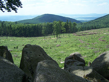
Oberhof - Schmiedefeld am Rennsteig
Distance from Oberhof center to Schmiefefeld town center: about 15 km (with a detour to the Schneekopf and the Großer Finsterberg between 18 to 20 km)

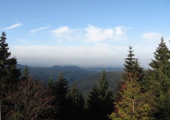
The Rennsteig crosses the summit region of the Thuringian Forest between Oberhof and Schmiedefeld. Here you will find the three highest mountains in the range. The day's stage was chosen to be rather short, so that there was enough time for the "mountain show" a little off the route. A visit to the Snow head (with 973 m highest mountain in the Thuringian Forest) and possibly also the Great Finsterberg. From both mountains you have an attractive view of the valley.
Corner points of the route:
- km 0 Oberhof-Rondell (826 m; Rkm 64.0) at 50 ° 39 '24 "N.10 ° 44 '36 "E - See above for information
- km 4.9 Pläckner's view on the Großer Beerberg (approx. 970 m; Rkm 68.9) at 50 ° 39 '24 "N.10 ° 43 '12 "E - The Rennsteig brushes against the summit of the 982 m highest mountain in the Thuringian Forest. The highest point of the entire Rennsteig is also located here. Right here on the path is near the summit of the "Pläckners Aussicht" lookout point with a view of Suhl. At the approximately 3 m high viewing platform, boards provide information about the Rennsteig pioneer Pläckner. Otherwise there is no possibility of a view on the Großer Beerberg. The wooded summit has been protected as a high moor since 1939 and is not allowed to be entered.
- Snow head 978 m - From the treeless summit you have one of the most beautiful Panoramic views in the Thuringian Forest. The approximately 1.5 km long detour from the Rennsteig is definitely worthwhile in good weather. In June 2008 the newly built lookout tower was opened on the mountain. The tower turns the mountain into a "one-thousand-meter". The glazed viewing platform (without elevator) is located at 1001 m and 12.5 cm above sea level. Admission: € 2 (coin-operated machine; have small change ready: the machine accepts 10, 20 and 50 cent pieces as well as 1 and 2 euro coins) Opening times: beginning of May - end of September: 9 a.m. to 6 p.m., beginning of October - End of April: 9 a.m. - 4 p.m.
- Settlement Decorate (at about 900 m) at 50 ° 39 ′ 13 ″ N.10 ° 46 '26 "E - Here you can in Waldhotel Schmucke stop by and stay overnight.
- km 11.8 Borstenplatz (879 m; Rkm 71.8) - Here is the Herbert Roth memorial stone. It is reminiscent of the Suhl composer Herbert Roth (1926-1983). Herbert Roth composed the famous Rennsteig song.
- Great Finsterberg - On the third highest mountain in the Thuringian Forest with a height of 944 m there is a freely accessible viewing platform. A detour from the Rennsteig is possible and worthwhile.

- 1 Rennsteig train station (approx. 750 m) in the area of the pass 50 ° 36 '55 "N.10 ° 50 ′ 8 ″ E: "formal" end point of this Rennsteig stage; For more information, see the following stage
Alternative overnight accommodations to Schmiedefeld (extends the stage by around 2 - 4 km):

- If you don't want to deviate far from the route, you can stay overnight in the Waldhotel Rennsteighöhe (Frauenwald), which is located east of the "Rennsteig" train station in a secluded location right on the ridge. As an excursion program, you can also use the former NVA bunker visit.
- Another option to stay overnight is Frauenwald. The resort is located very scenic on a sunny plateau about 2-3 km south of the ridge path. With a detour to the village you do not suffer any great loss of altitude relative to the Rennsteig, as Frauenwald is at an altitude of around 750 m.
Schmiedefeld am Rennsteig - Masserberg
Center of Schmiedefeld am Rennsteig - center of Masserberg: about 20 km
Corner points of the route:


- 2 Rennsteig train station (approx. 750 m) - Former crest station of the Rennsteigbahn, which today houses an information center for the "Vessetal" biosphere reserve. It is also possible to stop at the gastronomy ("historic goods floor", open daily 11 am-5pm). Further information: www.bahnhof-rennsteig.de. The Wikipedia article on the Rennsteig train station.
- 3 Bunker Museum at the Waldhotel Rennsteighöhe. The bunker museum is not directly on the route - but it is worth a detour for those interested. The completely preserved state security bunker from GDR times can be visited (Info like tour times) (Meeting point for guided tours at the Waldhotel). in the Forest hotel you can stay overnight.
- 4 All too close (775 m) - Small settlement directly on the ridge, which is politically too Frauenwald belongs. Hikers' parking lot at the western entrance to the village.
- 5 Rest area with refuge halfway between Großer Hundskopf and Dreiherrnstein.
- 6 Großer Dreiherrenstein (808 m) - The boundary stone is usually only briefly called "Dreiherrenstein". The first mention of the historical crossroads and the border point can be found in the Henneberg forest description from 1587 ("Dreier Herren Stein"). The year 1596 is carved into the border stone standing here today with the coats of arms of the former border neighbors (for more information see Wikipedia article "Großer Dreiherrenstein").
- Refreshments in the Forest chalet "Großer Dreiherrenstein"
- 7 "Middle of the Rennsteig" - the "middle" of the Rennsteig is only a few hundred meters behind the Großer Dreiherrenstein
- 8 Neustadt am Rennsteig with Rennsteig Museum - The small museum houses a library on the Rennsteig. There are numerous books about the hiking trail as well as extensive documentation about the boundary stones along the way. Open Mon-Fri from 10 a.m. to 4 p.m. For groups of 5 people or more, an opening can also be arranged outside of the opening times (Museum side). Gastronomy and overnight accommodation in town. A small supermarket ("Nahkauf") for self-catering can be found after the roundabout east of the main road.
- → Parallel to Kammstrasse, it goes towards Kahlert. In this section the ridge remains largely free of forest, so that some Valley views surrender.
- 9 Kahlert - small settlement on the ridge that belongs to Neustadt am Rennsteig.
- → For the next 4 km to the "road pass" Schwarzenhauptwiese, the Rennsteig again runs parallel to Kammstraße.
- 10 "Pass Schwalbenhauptwiese" (703 m) - Refuge and parking lot. Four streets meet here. If you take a closer look at the map, you will find that it is a topographically favorable transition from the Werraniederung south of the mountains through the Schwarzatal to the Saale valley north of the Thuringian Forest (therefore possibly an old regional trade route?)
- 11 Triniusstein (approx. 710 m) - can be found just behind the pass. Memorial stone to August Trinius (1851 - 1919), who as a traveling writer wrote several books about the Rennsteig. In the area of the memorial stone is also the Triniusbaude (Refreshment possibility).
- → The Rennsteig now leaves Kammstrasse. On beautiful, small paths away from the traffic through the forest, you climb steadily (sometimes over a few steps) up to the Ersteberg.
- 12 Rastplatz Ersteberg (at about 825 m)- Rest area with a refuge in the middle of the forest
- → On the road, the route bypasses the ski lift on Ersteberg. Before Masserberg the landscape opens up again and you have a nice one Valley view Towards the southwest.
- 1 Masserberg: Crossing on the main road (approx. 785 m) at 50 ° 31 '4 "N.10 ° 57 ′ 56 ″ E - "Rennsteig" car park with the Masserberg bus station. Rennsteighaus (?) In the parking lot. There is also an obelisk with a bench, which was rebuilt in 2002 by the Thuringian Forest Association Masserberg. Next to the sign there is a cute little Rennsteig man made of wood. From here it is only a few hundred meters to the center of Masserberg. It is even closer Thermal bath, in which you can relax after the stage.
Masserberg - Neuhaus am Rennweg


The Rennsteig leads directly through both places. Stage length: about 20 km
Corner points of the route:
- Masserberg: crossing on the main road (approx. 785 m) at 50 ° 31 '4 "N.10 ° 57 ′ 56 ″ E - See above for information
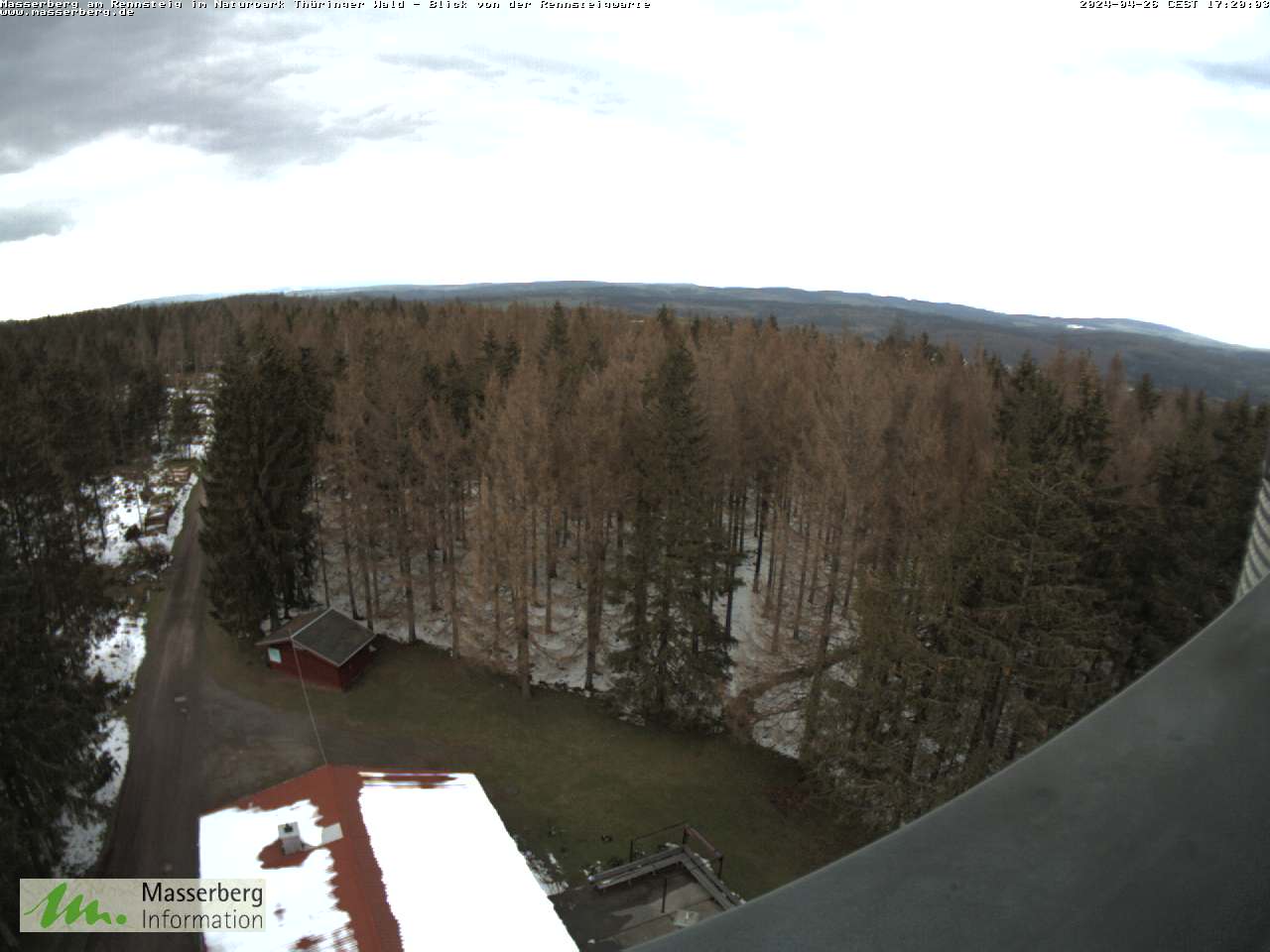
- Rennsteigwarte observation tower on Eselsberg (841 m) - 30 m high observation tower, the panorama is shown below the window glazing with lettering of the objects in the best photos. A recommendation for many observation towers in Germany. Webcam on the tower. Gastronomy at the tower, tower opening times: Mon-Sun 11 am-5pm; Entry € 1
- Dreiherrnstein on the Hohe Heide (832 m) Rkm 100.0 - The boundary stone once separated the three principalities of Schwarzburg-Rudolstadt, Saxony-Meiningen and Schwarzburg-Sondershausen. From Hörschel, the stone marks the 100-kilometer mark on the traditional direction of the Rennsteig.
- Eisfelder Ausspanne (757 m) at 50 ° 29 '34 "N.10 ° 59 ′ 16 ″ E - Rest area with refuge. By the way, the shortest stagecoach route from the Werra valley to the Schwarzatal ran over the wayside cross with 6 paths.
- Pechleite (839 m) - Rest area with refuge and the Germarstein. The white quartz stone marked a border.
- Friedrichshöhe (800 m) at 50 ° 28 ′ 42 ″ N.11 ° 0 ′ 55 ″ E- Thuringia's smallest municipality with restaurants and overnight accommodations. You can find it in the hamlet Information center of the Thuringian Forest Nature Park. An exhibition on the natural area of the Thuringian Forest will be shown with "sound-image-shows" (opening times: Mon-Fri 8 am-5pm, Tel .: 036704-70990). Parking spaces for hikers at the eastern entrance to the village.
- Dreistromstein (812 m) - The stone marks the watershed between the Rhine, Weser and Elbe.
- Limbach (737 m) - Small place on the Rennsteig. in the House of the guest in Limbach (Tourist info) there is a sales exhibition for original Thuringian Christmas tree decorations and handicrafts. · If you have a little more time, you can take a detour from the Rennsteig to the nearby area Steinheid and buy there directly from the manufacturers of the Christmas tree decorations.
- Sandberg (828 m) - Boundary stone, summit sign with altitude information on the way.
- Sandwieschen (777 m) - Parking lot, rest area with shelter. To Schwarza spring It's only 400 m from here (but steeper downhill). On the further way to Neuhaus, it is worth making a detour from the route to the "Weidmannsheil" lookout point 50 ° 29 ′ 33 ″ N.11 ° 5 '48 "E. From here you have a beautiful view of the Scheibe-Alsbach dam and the heights of the mountains.
- Rennsteigbaude Bernhardsthal (819 m) - Inn - Possibility to stay overnight in the Hiking huts on the Rennsteig
- Neuhaus am Rennweg train station (830 m) at 50 ° 30 '25 "N.11 ° 8 ′ 13 ″ E: End of the stage. From here there is a rail connection via Sonneberg to Bamberg. If you don't stay overnight in Neuhaus, you should definitely make a detour to the wooden church in Rennsteigstadt, which is well worth seeing. Those who need "food for the march" will find a supermarket (Lidl) just before the train station. For gastronomy and guest beds, see city articles Neuhaus am Rennweg.
Neuhaus am Rennweg - Steinbach am Wald

Entfernung Rennsteig Bahnhof Neuhaus am Rennweg - Steinbach am Wald: etwa 21 bis 22 km
Eckpunkte der Strecke:
- Bahnhof Neuhaus am Rennweg (830 m) at 50° 30′ 25″ N11° 8′ 13″ O: Start der Etappe.
- Kustel beim Igelshieb in Neuhaus am Rennweg at 50° 30′ 7″ N11° 9′ 6″ O - Seit September 2011 steht hier direkt am Rennsteig der "Kustel". Die putzige, mannshohe Holzskulptur ist das heimliche Maskottchen der Rennsteigstadt Neuhaus am Rennweg. Kustel bedeutet übrigens so viel wie "Tannenzapfen".
- Ernsthal am Rennsteig - Die Gemeinde umgeht der Rennsteig nordwärts
- Rastplatz "Laubeshütte" (etwa 840 m) - Mitten im Wald etwa 1,5 km östlich von Ernsthal am Rennsteig gelegen. Der kurze Abstecher (100 m) zum attraktiven Aussichtspunkt "Frankwaldblick" it's worth it.
- Höchster Punkt am Rennsteig im Landkreis Saalfeld-Rudolstadt; gelegen auf 827 m; Hinweisschild mit Bank und Tisch zur Rast sind vorhanden.
- Berggasthof & Finnhütten "Am Brand" (830 m) - Einkehrmöglichkeit und Übernachtungsmöglichkeit in 8 kleinen Spitzgiebelhäuschen aus Holz (info)
- Spechtsbrunn (etwa 700 m) - Kleines Dorf am Kamm; Matthäuskirche mit sehenswerter Innenausstattung; Naturparkinformationszentrum
- Kalte Küche - Straßenverzweigung östlich Spechtsbrunn, Wanderparkplatz, Gastronomie
- Mahnmal Rennsteig an der Frankenwaldbaude (Einkehrmöglichkeit)
- 11 Steinbach am Wald (etwa 600 m) - Ortsmitte, Abzweig zum Bahnhof (Bahnanschluss an die Hauptstrecke Saalfeld - Bamberg)
Steinbach am Wald - Blankenstein an der Saale bzw. Bad Steben
Entfernung Rennsteig Steinbach am Wald - Blankenstein an der Saale: 28 km.
- Der Bahnhof befindet sich in Blankenstein nahe des Wegendes. Vom Bahnhof Blankenstein besteht Richtung Norden Bahnanschluss Richtung Saalfeld (Saale) (Fahrzeit 1 h und 15 Minuten). In Saalfeld kann man in den ICE umsteigen (ICE-Linie Berlin - Leipzig - Jena - Nürnberg - Ingolstadt - München) (Seit 2017 kein ICE-Halt mehr.).
- Wer möchte, kann den Rennsteig auch schon vorher verlassen und nach Bad Steben wandern. Entfernung dann etwa 24 km. Von Bad Steben besteht Bahnanschluss nach Hof (Fahrzeit 48 Minuten). Von dort gibt es mit dem Regionalexpress direkte Verbindungen Richtung Nürnberg und Dresden.
Eckpunkte der Strecke:

- 12 Steinbach am Wald - Ortsmitte, Abzweig zum Bahnhof
- 13 Abzweig für den Abstecher zum Wetzstein (792 m) - Der Abstecher ist lohnend, da auf dem Berg der schmucke, 35 m hohe Altvaterturm steht. The bewirtschaftete Turm lädt zur Einkehr ein. Zugang ist unklar (Der Kontakt für Führungen durch das Bauwerk steht aber auf der Seite des Altvaterturmverein e. V.). Hintergrund zum Bauwerk siehe auch Wikipediaartikel "Altvaterturm (Wetzstein) ". Der Rennsteig selbst verläuft ein Stück südlich am Gipfel vorbei (ohne Sicht auf das Bauwerk ).
- Brennersgrün - Die Miniaturwelt am südlichen Ortsausgang bei 14 zeigt 70 aus Naturmaterialien hergestellte künstlerische Objekte und nachgeahmte Modelle von Gebäuden aus der Rennsteigregion. Die 200 qm große Miniaturwelt ist frei zugänglich. Es kommt daher schon mal zu Unordnung, wenn sich ein Tier an den Kunstwerken zu schaffen macht.
- 15 Straßenquerung bei Grumbach - Schutzhütte
- 16 Rodacherbrunn
- 17 Am Beerholz (666 m) - Rastplatz, Aussichtspunkt
- 18 Schlegel - kleines Dorf mit Gastronomie
- 19 Kießling - kleines Dorf mit Gastronomie
- 20 Blankenstein, Ende des Rennsteigs an der Selbnitzbrücke (etwa 420 m, Rkm 168,3) - Wer möchte kann hier seinen von der Werra als Glücksbringer mitgebrachten Stein in die Selbnitz werfen. Ferner stehen hier als letzte Rennsteigexponate noch ein "Wanderschuhdenkmal" und ein Gedenkstein an Julius von Plänckner. Gut zu wissen: 80 m nördlich befindet sich eine öffentliche Toilette.
trips
Wer nach einer Rennsteigwanderung Lust auf Kultur hat, kann mit einem "Stadttag" in Erfurt or Weimar den Thüringenurlaub abrunden.
- The Kammweg ist eine Wanderweg, der von Altenberg-Geising im Eastern Ore Mountains durch das Vogtland nach Blankenstein in Thüringen zum Rennsteig führt. In 17 Tagesetappen können die insgesamt 286 Kilometer, mit rund 2600 Höhenmetern bewältigt werden.
literature
digitale Karten:
- Verlauf des Rennsteigs auf Openstreetmap (ist Relation Nr. 398874; evtl. etwas Ladezeit)
weitere Literatur:
- Allgemein: Rennsteigliteratur im Verlag Grünes Herz - Der Verlag mit Sitz in Ilmenau gibt zahlreiche Wanderkarten und -führer für die Region Thüringer Wald heraus. Auch zum Rennsteig gibt es natürlich einige Führer. · Erwähnenswert ist der Rennsteigführer "Von Blankenstein nach Hörschel". Das Buch von Horst Golchert (ISBN 978-3-86636-153-9 , 6,95 €) beschreibt den Wanderweg entgegen der üblichen Laufrichtung. · Infos zu den weiteren Titeln : siehe Verlag Grünes Herz.
- Hikeline Wanderführer "Fernwanderweg Rennsteig" - Führer mit genauen Karten im Maßstab 1:35.000. · 2. Auflage Juni 2010, ISBN 978-3-85000-505-0 , Spiralbindung, erschienen für 13,90 € im Esterbauer publishing house.
- Wanderführer Rennsteig & Thüringer Wald - Rennsteig in beiden Verlaufsrichtungen und 17 Rundwanderungen; Dumont Reiseverlag; ISBN 978-3-770180-455 ; 5. Auflage März 2012; 12,99 €
- Für Ski Nordisch auf dem Rennsteig: 3-teiliges Kartenset "Wintersport im Thüringer Wald". Die Karten in einer Schutzhülle zeigen Skiwanderwege, Loipen und Pisten. ISBN 978-3-86973-015-8 der Auflage 2011/ 2012: 4,50 € Kartographische Kommunalen Verlagsgesellschaft mbH
Web links
- www.rennsteigverein.de - Wanderverein zur Route
- rennsteigregion-im-frankenwald.de - Touristinformation der Rennsteigregion im Frankenwald
- www.rennsteig-rueger.de - private, nichtkommerzielle Seite von Ulrich Rüger zum Wanderweg mit präzise recherierten Hintergrundinfos und aktuellen Jahreschroniken zum Wanderweg (Jahre 2008 bis 2011)