 | ||
| Rhön | ||
| federal state | Hesse | |
|---|---|---|
| Residents | unknown | |
| no value for residents on Wikidata: | ||
| height | 950 m | |
| no tourist info on Wikidata: | ||
| location | ||
| ||

The Rhön is a low mountain range in the middle Germany, located in the country triangle Hesse, Thuringia and Bavaria.

Regions
| location | ||
| ||
Distribution according to topography
Hochrhön, also Hohe Rhön:
- Dammersfeldback, formerly the real one High Rhön, the central part of the mountain - unfortunately largely in the restricted area of the Wildflecken military training area and not accessible to tourists.
- Long Rhön, an elongated high plateau in the east of the Hochrhön, extends in north-south direction from the Elbow in Thuringia (Eisenacher Haus) to the Heidelstein and the Bauersberg north of Bischofsheim on the Rhön, essentially belonging to the biosphere reserve in terms of area. In Oberelsbach is the information center House of the Long Rhön to the UNESCO Biosphere Reserve Rhön.
- North of the Dammersfeldrückens and west of the Long Rhön forms the highest mountain of the Rhön, the Wasserkuppe, its own massif.
- The Black mountains (named after the dark basalt rock that forms them, most famous mountains: Feuerberg, Totnansberg, Farnsberg and Platzer Kuppe) is the area between Wild spots and Bad Bruckenau and located south of the Dammersfeld ridge. The mountains in this part of the Rhön, unlike the grassy summit areas of the other Rhön mountains, are mostly covered with dense spruce forest up to the highest point (reforested in the 1950s and 1960s). The "Black Mountains" are one of the largest extra-alpine nature reserves in Bavaria. in the Wildfleckener The Oberbach district is where the information center is located House of the Black Mountains.
- The one to the east of it Kreuzberg-Massiv is clearly demarcated from the neighboring Rhön Mountains by partly deep valleys.
Kuppenrhön and Rhön foreland:
- Kuppenrhön or crooked Rhön, in Bavaria, Hesse and Thuringia the area to the west (Brückenauer Kuppenrhön) and north (Milseburger, Soisberger and Auersberger Kuppenrhön) the Hochrhön, with the characteristic landscape of the dome-shaped individual mountains from the weathered and isolated remains of former volcanic vents without connected ridges.
- Vorderrhön, in Hessian the area north of the Kuppenrhön, in Thuringia the Kuppenrhön is also part of the "Vorderrhön";
- Vor-Rhön, in Franconian the region Rhön-Saale as lower parts of the landscape south and east of the Black Mountains, the Kreuzberg and the Long Rhön to the Franconian Saale and until Grave field;
Political distribution according to federal states
- Hessian Rhön (District of Fulda)
- Franconian (Bavarian) Rhön (Districts of Rhön-Grabfeld and Bad Kissingen)
- Thuringian Rhön (Districts of Schmalkalden-Meiningen and Wartburg district)
places

Franconian Rhön

- 1 Bad Bruckenau


 in the Wikidata database") - Bavarian state bath with history.
- Bavarian state bath with history. - 2 Bad Bocklet - Bavarian state bath in the valley of the Franconian Saale.
- 3 Bad Kissingen - Bavarian state bath and most famous health resort in Germany.
- 4 Bad Neustadt an der Saale - Bavarian State Bath at the foot of the Rhön.
- 5 Bischofsheim on the Rhön - Wood carving town at the foot of the Kreuzberg.
- 6 Fladungen - medieval romantic half-timbered town.
- 7 Hammelburg - the oldest wine town in Franconia.
- 8 Mellrichstadt - The “young city within old walls”.
- 9 Münnerstadt - on the southern edge of the Bavarian Rhön Nature Park, magnificent half-timbered buildings.
- 10 Oberelsbach - Market town and state-approved resort.
- 11 Ostheim before the Rhön - with the largest fortified church in Germany.
- 12 Wild spots - with the information center "House of the Black Mountains" in the Oberbach district;


Hessian Rhön

- 1 Dipperz
 - Gate to the Hochrhön;
 - 2 Ehrenberg - in the Ulstertal, with the climatic health resort Desert saxons;
- 3 Oak cell - with the most beautiful baroque palace in Hesse, Schloss Fasanerie;
- 4 Ebersburg - with the castle ruins of the same name;
- 5 Fulda - Episcopal city and place of work of St. Boniface.
- 6 Gersfeld - "secret capital" of the Rhön, game park open all year round.
- 7 Hofbieber - in the middle of the "hilly Rhön";
- 8 Hünfeld - City in the Haunetal with the Konrad-Zuse-Museum (inventor of the computer);
- 9 Hilders - State-approved climatic health resort;
- 10 Künzell - municipality near Fulda;
- 11 Petersberg - near Fulda with the church of St. Lioba;
- 12 Poppenhausen (Wasserkuppe) - at the foot of the Wasserkuppe;
- 13 Rasdorf - Village with 1225 years of history in the "Hessian skittles"
- 14 Fir - historical Rhönstadt.


Thuringian Rhön
- 1 bad Salzungen - Spa town with brine thermal baths.
- 2 Dermbach - Community in the Kuppenrhön with a castle.
- 3 Frankenheim - Municipality in the triangle.
- 4 Geisa - City not far from Point Alpha on the Hessian border.
- 5 Kaltennordheim - City in the Vorderrhön.
- 6 Meiningen - Theater and residence city.
- 7 Merkers-Kieselbach - with the Merkers adventure mine.
- 8 Vacha - with Wendelstein Castle.


Other goals
- To the Biosphere reserve see the following section background.
- The Green ribbon is the first all-German nature conservation project and was created along the former inner-German border strip, which impenetrably separated the Thuringian part of the Rhön from the rest during the Cold War.
background

Geographically, the Rhön borders the north-west Vogelsberg, in the west to the Spessart, in the south to the Franconian Saale, in the southeast to the Grave field and in the northeast to the Thuringian Forest.
"Land of the Open Afar" is a term used mainly by the tourism industry for the Rhön: The slogan tries to describe the impression of the unwooded and thus promising hilly landscape of the Hochrhön.
history
The name "Rhön" probably goes back to the Celtic word "rain", the word Rain or "Rangen" for a slope is still in use today.
Scientifically researched hillside settlements on the Franconian Saale (Mittelstreu, Eiersberg, probably from the Mesolithic Age 4500 BC, secured from the Iron Age) and in the Hessian Rhön (Milseburg, Oppidum 1200 - 800 BC BC) are evidence of the first prehistoric cultures in the Rhön. There is evidence of a chain of ramparts on the "Öchsen", the "Hessenkuppe" near Dermbach, the "Ruthubge" near Kaltensundheim, the "Dammersfeld", the "Kreuzberg" as a selection.
In the Middle Ages, centers of culture were the monastery Fulda and the Kaiserpfalz Bad Neustadt.
Geology and volcanism
The Rhön is part of a chain of volcanic centers that extend from the Eifel on the Westerwald, the Vogelsberg and the Rhön itself until after Silesia extends. By radiometric dating of the age of the rock, the volcanic activity in the Rhön is documented for the period from about 25 to 11 million years ago, with the end of the main activity about 18 million years ago.
The area of the Hochrhön is essentially made up of a layer of extensive volcanic rocks from the Tertiary era.w: tertiary (geology) The area rises with the almost 300 m thick volcanic rock layer more than 200 m above the terrain of the neighboring areas of the Rhön foreland and the Kuppenrhön.
The hilly mountainous area of the Kuppenrhön, which is made up of individual peaks (e.g. Milseburg, Wachtküppel, Steinwand, with heights of 650 to 839 m) is the result of the erosion of the surrounding softer rock exposed phonolite bodies of former underground cooled magma conveyor chimneys and passages from the Triassic period w: Triassic (geology).

In the Rhön foothills, volcanism plays almost no role. The area is mainly made up of rocks from the Lower Triassic Period (red sandstone).
From the end of the 19th century, in step with the traffic and technical development of the Rhön, basalt mining began on a large scale. Basalt works emerged and offered the population in the previously less industrialized area a regular income and regular working hours compared to the toil of agriculture. The main area of application of the mined basalt was the construction of dams on the coasts of northern Germany and Holland. Today, basalt mining in the Rhön is practically irrelevant. The former mining areas such as the Stone House above Ginolfs or the Silbersee near the Rother Kuppe have been renatured and serve as recreational areas.
Biosphere reserve
 Lange Rhön, UNESCO biosphere reserve |
 Winter in the biosphere reserve |
Biosphere reserves are worldwide model landscapes by UNESCO. Since March 4th, 1991, shortly after reunification, the Rhön has been recognized as a biosphere reserve by UNESCO as a whole through the work of the nature conservation authorities from the three individual regions of Bavaria, Hesse and Thuringia.
The Rhön Biosphere Reserve is divided into a core zone, a maintenance zone and a development zone, depending on the influence of human activity.
The Core zone is not inhabited and is not cultivated or maintained. These are mainly semi-natural deciduous forests and moors with a share of only 2.7% of the total area of the biosphere reserve.
The Care zone are those areas that are particularly characteristic of the Rhön landscape with a species and structure rich agricultural landscape together with near-natural forests. Traditional land use is of the utmost importance here to preserve these landscapes. The maintenance zone accounts for 36.4% of the total area and is again divided into maintenance zone A with the particularly sensitive and undisturbed high altitudes of the Hohe Rhön around the Lange Rhön and the Rote Moor, and a maintenance zone B for the other particularly characteristic cultural landscapes.
The Development zone At 60%, it has the largest share in the Rhön Biosphere Reserve. These are the areas with favorable locations for agriculture and forestry, settlements and industrial areas. This model room is intended to show that humans can use the biosphere without destroying it.
Through the management of the project, a large number of projects on the topic, such as agriculture and forestry, environmental education, settlement, water management and tourism, are supervised, organized and informed in the development area. Information points of the administration of the biosphere reserve see section Get along.
regional customs

- Easter fountain. Originally based in the nearby area Franconian Switzerland the custom of the Easter fountain has also spread in the Franconian part of the Rhön in recent years. In many villages, the fountains are lavishly decorated at Easter.
Rhön sheep
Rhön-Hilde is the name for the Rhön marketing mascot, it comes from the Rhön sheep breed, one of the oldest farm animal breeds in Germany. The animal species was first mentioned by name in 1846 and its characteristic form can be documented as early as the 16th century: The Rhön sheep is characterized by its hornless, black-haired, uncooled head and, in contrast to the better-known northern German heather sheep, its white legs.
The Rhön sheep started their first international career in 1813 under Emperor Napoleon. On one of his campaigns Napoleon tasted the meat of the animals in the Rhön and then, because of the high quality of the meat, had migrant herds imported from the Rhön to Paris, where the sheep were sold under the brand name "mouton de la rein", which means "royal." Sheep "meant when slaughter cattle and delicacies were sold. As a result, the breed was spread over almost all of Germany.

At the end of the 19th century the stocks declined due to cattle disease control campaigns and import restrictions in France, for 1960 only 300 specimens of the Rhön sheep are listed in the herd books of the western federal states at that time, the species was threatened with extinction. Due to the particular suitability for the rough, humid climate of the low mountain range, however, the populations began to recover in modern times, the robust animal breed currently comprises around 10,000 listed animals again. In midsummer, the herds of Rhön sheep are again part of the landscape of the Hochrhön; they help with the maintenance of the landscape of the extensively cultivated grasslands and the tasty meat of the animals is again a regional specialty.
The mascot "Rhön-Hilde" caused discussion and displeasure, initially portrayed by comic artist Alex Ziegler like the Heidschnucken with black legs (possibly out of artistic freedom or simply out of ignorance). At the moment, however, the waves of resentment have smoothed out somewhat: the black legs are now black socks, and other colors are planned for these socks in the future.
Information about the Rhön sheep at the GO;

Gym wheel
The sports equipment consisting of two tires with six cross bars was produced in 1925 by Otto Feick in Schönau a.d. Brend patent pending. The gym wheel was presented internationally for the first time at the 1936 Olympic Games in Berlin. In 1959, gymnastics was included in the German Gymnastics Federation, and the first world championships took place in Den Helder (Netherlands) in 1995. The sport is organized in the IRV (www.rhoenrad.com).
More information about the gym bike at Gym wheel and at wikipedia: Gym wheel;
language
The Rhön Mountains have been an East Franconian cultural area since the early Middle Ages, so the language of the Rhön residents is an East Franconian dialect in its roots.
Due to the location of the mostly quite small settlements with fragmented regional rulers in an inaccessible mountain range and also as a result of the low mobility of the simple rural population, small linguistic islands with partly strongly differing subspecies of the Rhön dialect emerged: even over short distances of just a few kilometers the dialect of one place can sometimes only be understood with great difficulty by the residents of the neighboring village after that. The extreme example here is the space around the location Oberelsbach: even those who think they can still understand the Lower Franconian or even Rhöner Platt (the Rhöner Platt has nothing to do with the dialect of the North German Platt) will find it very difficult to follow the real dialect of an older Oberelsbach citizen.
In addition, there is also a regional language coloring based on the Hessian and Thuringian rule. Linguists today draw the line between Hessian and East Franconian somewhere in the northern part of the Rhön: East Franconian is accordingly Upper German, with Hessian influence there would be a Central German dialect, and the Thuringians "sächeln" for Lower Franconia.
In general, in Franconian dialect, the "K" becomes a "G" and the "P" becomes a "B". The subtleties of the dialect are then the frequent replacement of the letter "W" at the beginning of the word with the "B": "bann then" means "wann denn" in High German and "bu" means "wo". Further dialect examples are "nachde" for yesterday and "uenzichnachde" for the day before yesterday.
With increasing mobility of the population at the end of the 19th and beginning of the 20th century and by more modern school systems, the dialect was "expelled" and weakened in the sense of High German, and at the latest with the media of the modern era, the Rhön dialect is now in the language of the younger population only very stunted.
The dialect variants of the Rhön experience a modern and successful revival in the texts of various Rhön musicians, often combined with modern music.
See also the paragraph on Language in the Rhön-Saale region.
getting there

In the street
The runs from north to south Autobahn 7, the "Rhönautobahn", between Fulda and WurzburgThe connection points are Fulda-Süd / Eichenzell, Bad Bruckenau, Oberthulba / Bad Kissingen and Hammelburg.
The A71, the "Thuringian Forest Highway", has been open continuously since the end of 2005 and connects the cities Schweinfurt and ErfurtConnection points are in the area of the Rhön Münnerstadt, Bad Neustadt, Mellrichstadt and Meiningen.
By train
The cities Bad Neustadt, Mellrichstadt and Meiningen are on the railway line Schweinfurt–Erfurt located. The Schweinfurt – Meiningen section is also known as the Main-Rhön Railway. To Bad Kissingen continues to run the Schweinfurt – Gemünden line (Franconian Saale Valley Railway). At the Werra Railway are bad Salzungen and Meiningen, the cities Wurzburg and Fulda are connected to the ICE rail network.
The regional Rhön railway network has been thinned out in recent years. The only remaining branch line is the Rhön Railway, which runs from Fulda to Gersfeld. The Rhön Railway serves the following stops: Fulda, Eichenzell, Welkers, Rhönshausen, Lütter (Memlos), Ried, Schmalnau, Altenfeld, Gersfeld
By plane
If you want to travel with your own aircraft, as long as the aircraft is not too big, you have a wide range of options: see the section on Aviation in the Rhön.
mobility
- Automobile: The Rhön is a rural region. The car is the easiest and most flexible way of getting around.

- Train: There is no rail connection through the Rhön Mountains themselves. Various railway lines traverse the edge of the low mountain range and are suitable for the cities with train stations.
- Bicycle: Those who are accordingly sporty can get around by bike, but should look carefully at the distance of the destinations beforehand. With the differences in altitude in the low mountain range, the stages can be quite strenuous.
- Regional bus: The regional bus as a public means of transport is only conditionally suitable for tourists. The destinations are approached differently (rarely). If you need to change trains, you should plan for longer waiting times. The landscape of the Hochrhön is served with only a few stops.
- Public transport Rhön-Grabfeld (Transportation): www.nahverkehr.rhoen-grabfeld.de; Line network;
- Info: Rhein-Main transport association (Hessian Rhön);
- Public transport Meininger Busbetriebe (Thuringian Rhön): Lines 408 - 412 and 420, Lines of Meininger Busbetriebs GmbH
- Leisure bus routes:
- RhönRadBus: On Sundays and public holidays, from May 1st to October 3rd 2011, a leisure bus with free bike transport runs from Fulda along the Milseburgradweg to Hilders, then up along the Ulstertal cycle path, further up to the Wasserkuppe and back down to the train station Gersfeld. There is a connection with the Rhön Railway to Fulda. Location plan, Timetable 2011
- Hochrhönbus: In the Franconian Rhön the Hochrhön bus runs on Saturdays, Sundays and public holidays from May 1st to October 3rd. It is possible to take bicycles with you. www.hochrhoenbus.de, Info brochure 2011, Route map, Timetable 2011
- Taxi: Taxis are only available in the larger towns. If you have to travel a long way, transport by taxi is therefore expensive.
Tourist Attractions
The Rhön is a fascinating landscape, unspoilt and romantic. Since 1991 it is for UNESCO biosphere reserve The landscape offers a multitude of tourist attractions for hikers and nature lovers:
mountains


Important or significant mountains and peaks, sorted by height:
Wasserkuppe
The 1 Wasserkuppe![]()
![]()
![]() At 950 m, it is the highest Rhön summit and mountain, the glider pilot with the oldest gliding school in the world. Students from Darmstadt developed the basics for modern gliding here around 1910.
At 950 m, it is the highest Rhön summit and mountain, the glider pilot with the oldest gliding school in the world. Students from Darmstadt developed the basics for modern gliding here around 1910.

As a relic from the Cold War, one of the last of the former four radomes (radome domes) for military air surveillance is located on the summit. This dome has been decommissioned and is to be retained as an attraction. On the west side, a little below the radome, is the memorial of the glider pilots. On the south side, near the large car park, is the fused Fulda spring. Together with the Werra, the Fulda is one of the two source rivers of the Weser. There is also a double summer toboggan run on the Wasserkuppe, the German Glider Museum, an airfield with several runways and, when the weather is nice, a lot of flight operations, a youth education center, hotels, restaurants and tourist shops, a weather station, and, best of all, a wonderful one View all around in all directions. A "geological educational trail" leads to the neighboring horse head.
The summit is a wide "knoll", the whole area can be easily hiked from the parking lot.
Approach from the south / west: via the connecting road Gersfeld - Ehrenberg (Wüstensachsen district);
Coming from the north: via the Hochrhönring;
Parking: large car park immediately south of the summit plateau;
More detailed information is available in the separate article on Wasserkuppe;
Dammersfeld

The 2 Dammersfeld, also Dammersfeldkuppe, is with 928 m height the second highest Rhön summit and highest mountain of the Dammersfeldrückens, with the one to the east of it Eierhauckberg (910 m) also belongs to the fifth highest mountain of the Rhön. To the north of the summit are the Ottersteine, three mighty basalt rocks.
The mountain is located in the Wildflecken military training area, which is closed to tourists and, as a "shelling mountain", is inaccessible for military exercises because of the large number of duds. A curiosity in the history of the Dammersfeld is the butter war: It was waged in 1278 between the Würzburg bishop Hermann and the Fulda abbot Konrad around the valuable pastures on the mountain, the abbot of Fulda was victorious.
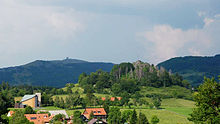
Kreuzberg

The 3 Kreuzberg![]()
![]()
![]() With a height of 928 m, it is the highest accessible Franconian Rhön summit with a centuries-old pilgrimage tradition to the widely known Franciscan monastery and the most visited tourist destination in the Rhön Mountains, also because of the pilgrimage church and the monastery brewery (since 1731). A way of the cross leads from the monastery to the summit plateau to the station with the triple group of crosses, the summit cross and the 208 m high transmitter mast of the transmitter Bavarian radio.
With a height of 928 m, it is the highest accessible Franconian Rhön summit with a centuries-old pilgrimage tradition to the widely known Franciscan monastery and the most visited tourist destination in the Rhön Mountains, also because of the pilgrimage church and the monastery brewery (since 1731). A way of the cross leads from the monastery to the summit plateau to the station with the triple group of crosses, the summit cross and the 208 m high transmitter mast of the transmitter Bavarian radio.
,_Südwestansicht.jpg/350px-Kreuzberg_(Rhön),_Südwestansicht.jpg)
Approach from east, north, south: via Bischofsheim on the Rhön (on the federal highway B279);
Approach from the west via the connecting road from Bad Bruckenau above Wild spots;
Parking: for the last time below the monastery (monastery: 12 min, summit: 25 min) paid parking lot;
More detailed information is available in the separate article on the Kreuzberg.
Heidelstein
The 4 Heidelstein![]()
![]()
![]() is the highest mountain (926 m, or better: "highest elevation", in the plateau of the "Long Rhön".
is the highest mountain (926 m, or better: "highest elevation", in the plateau of the "Long Rhön".
.JPG/320px-Heidelstein_(Wasserkuppe).JPG)
The mountain has a double peak. On the slightly lower east summit is the memorial of the Rhön Club, on the main summit the 218 m high transmission mast (Deutsche Telekom), which is visible from afar. In the north is the Ulsterquelle, the Ulster is a tributary of the Werra. From the west summit you have an overwhelming view (unobstructed view to the north, west and south).
The Heidelsteingipfel cannot be approached directly, the next hiking car park is on Franzosenweg (connecting road Desert saxons - Oberelsbach near the Hochrhönstrasse. Also from the parking lot at Red Moor (on the B 278 Bischofsheim - Wüstensachsen) you have a reasonably comfortable access to the summit.

Heavenly Dunk Mountain

The 5 Heavenly Dunk Mountain![]()
![]()
![]() or Sky dunk (888m, together with the High hell (894 m) a double summit and the northeastern end of the Dammersfeldrückens ("Hohe Rhön"). The wide, unforested hump on the summit plateau is a classic hiking mountain with various climbs (steep north slope!) And an unobstructed view to the east, south and west from the summit. The border between Bavaria and Hesse runs over the summit. On the east side a little below the summit is the "Wurzburger Hut"(Self-catering hut).
or Sky dunk (888m, together with the High hell (894 m) a double summit and the northeastern end of the Dammersfeldrückens ("Hohe Rhön"). The wide, unforested hump on the summit plateau is a classic hiking mountain with various climbs (steep north slope!) And an unobstructed view to the east, south and west from the summit. The border between Bavaria and Hesse runs over the summit. On the east side a little below the summit is the "Wurzburger Hut"(Self-catering hut).

How to get there: The highest approachable point is the Schwedenschanze, the pass at the St 3396 (shortly after the junction from the federal road B 278) between Bischofsheim and Gersfeld.
Bauersberg

The 6 Bauersberg at Bischofsheim on the Rhön is actually not a real classic mountain peak, but the southern end of the Long Rhön. But it has some tourist attractions to offer. First there is the Rothsee, a fish pond with a managed one Fishing club hut Bischofsheim. Then there is a geological nature trail with the accessible lignite tunnel "Unity" from 1844. Lignite mining in the Rhön has been in operation since the 16th century, but has since been abandoned because of the poor quality of coal. A viewing platform to the huge pit of the neighboring basalt works clearly shows the geological rock layers. The basalt rubble dump above the parking lot is a paradise for naturalists and has already been treated in numerous scientific studies. You can also enjoy the view to the northwest of the panorama of the mountains Kreuzberg, Arnsberg and Himmeldunkberg opposite.
Approach via the Hochrhönstrasse from Bischofsheim to Fladungen, junction approx. Two kilometers to Bischofsheim after a sharp left bend, parking lot at the geological nature trail and at the Rothsee;
Milseburg

7 Milseburg (835 m), legendary basalt mountain in the Hessian Kuppenrhön.
The summit with the crucifixion group from 1756 and the Gangolf chapel offers one of the best views of the Rhön. The one cultivated in summer is located directly below the summit Milseburghütte.
The remains of a Celtic settlement with a ring wall are located on the phonolite dome, which is overgrown with rubble forests. An archaeological hiking trail shows information about the excavations of the prehistoric oppidum, one of the largest Iron Age settlements in East Hesse from the late Bronze Age (1200-800 BC) and in the Iron Age (from 450 BC).
Approach via the connecting road Hilders - Small people - Poppenhausen (Wasserkuppe); Ascent to the summit from the designated parking lot in approx. 30-45 minutes; Proper walking shoes are mandatory on the rocky path, especially when it is wet.
More detailed information, especially for cyclists, is available in a separate article on Milseburg;
Elbow
The 8 Elbow (official summit height 814 m) is the northeast corner pillar of the high plateau of the Long Rhön.

The elbow is the remnant of an extinct volcanic vent and does not stand out from the plateau as a "hill" on site, it is clearly visible from the Ulstertal. The wide view of the Ulstertal is particularly worth seeing Southwest Thuringia and the distinctive block litter stones from the Ice Age.
The elbow also has a past in the "Third Reich": under the National Socialists, the "Saukelhof" labor camp was built here as a model complex for pasture management and cattle farming, which was modern at that time. In the course of the GDR's border security policy, these facilities were demolished almost without a trace due to their proximity to the inner-German border.
Today the elbow is part of the "Green ribbon" the former border and is e.g. an important resting place for rare species (lapwing) during bird migration. This is available locally as a restaurant Eisenach house (modern conference hotel) and as accommodation for hikers the restaurant Thuringian Rhönhäuschen;
In summer the region is a hiking area, in winter there is the Elbow ski and toboggan park Numerous groomed trails, a snow tubing facility ("Rhöner Gaudirutsche") and a tire slide for children.
In 2017, the Noahs Segel observation tower with a tunnel slide was opened at the summit of the Elbow.
The elbow is mentioned in various sources as the highest mountain in the Thuringian Rhön. According to the topographic maps, however, this is the highest point in the Thuringian Rhön the one 1.5 kilometers south of the neighboring one 9 Schnitzersberg with 815.5 m and a striking transmitter mast on the L1123. The Schnitzersberg, which is independent topographically and in terms of access, on the plateau of the Langen Rhön is sometimes added to the elbow itself, at Schneider's Rhön leader it is managed as an independent mountain.
Directions: About Frankenheim.

High Geba
10 High Geba or Geba, also Gebaberg, (751 m), highest mountain of the "Vorderen Rhön" in southern Thuringia near Stepfershausen and west of Meiningen. The mountain is an unforested plateau mountain and resembles the Hochrhön in its volcanic history. A viewing hill on the summit plateau shows a panoramic view of the Bavarian, Hessian and Thuringian Rhön. If the weather permits, the view extends to the Thuringian Forest, the Hassberge Mountains and the Hohe Meißner. At the summit is the Meininger Hut.
From 1961 to 1991 the Hohe Geba was closed to tourists by the Soviet Army stationed there. Since 1999 there has been an approx. Three hectare (one hectare (ha) = 10,000 square meter) large Rhön cultural garden with a reproduced Celtic village on the Geba. Historical workshops are offered here: weaving, pottery and carving like the Celts.
The Hohe Geba is to become the core zone of a star park in the Thuringian Rhön Biosphere Reserve, plans are currently underway for a new visitor center on the Hohen Geba, the groundbreaking should take place in 2014, the opening is planned for 2016.
Also in the planning stage is a 70 meter high observation tower, which is spectacularly inclined at 23.5 degrees, and has a celestial body slide. The 14 million project is controversial.
Directions: via Meiningen and Stepfershausen, parking spaces available on the plateau;

Gangolfsberg
11 Gangolfsberg (737 m) a wooded basalt dome north of Oberelsbach on the edge of the Langen Rhön with a prehistoric rampart from the time of the migration of peoples (fourth and fifth centuries AD) at the summit, also with the ruins of the Gangolf chapel, probably from the founding time of the Fulda Provostry in 8th century.
On the west side below the mountain peak are the honeycomb-like basalt columns of Teufelskeller and Teufelswand, the best preserved basalt prismatic wall in the Rhön. A nature trail provides information about the trees in the forest and their use. This is on the east side of the mountain Schweinfurt House.
Parkmöglichkeiten am "Franzosenweg" (Verbindungsstrasse Oberelsbach - Ehrenberg), ca. zweieinhalb Kilometer nördlich von Oberelsbach und am Schweinfurter Haus (Zufahrt über Urspringen).
Rother Kuppe

12 Rother Kuppe - Basaltkuppe (711 m) mit Aussichtsturm und (bei entsprechenden Witterung) einer Rundumsicht von bis zu 80 km nach Unterfranken und Thüringen. Turmbesteigung gegen freiwillige Gebühr.Am Turm befindet sich das Wanderheim Rother Kuppe des Rhön-Clubs, die Nordseite der Rother Kuppe ist im Winter ein beliebter Rodelhang.Anfahrt von Süden: von Mellrichstadt über die Staatsstraße Richtung Fladungen, in Nordheim Richtung Roth abzweigen, durch Roth hindurch und weiter Richtung "Hochrhön".Anfahrt von Norden, Nordwesten: Von der Hochrhönstraße Richtung Rhön-Path Hotel abzweigen.Parkplatz unterhalb der Kuppe,
Wachtküppel
13 Wachtküppel (705 m) markanter Felsenkopf aus Basalt nordwestlich von Gersfeld in der Kuppenrhön, auch "Spitzbub" genannt. Bietet eine weite Rundumsicht. Wegen der Eisenhaltigkeit des Basalts Störung der Kompassnadel. Am Bergfuß gibt es einen aufgegebenen Steinbruch mit Grillplatz. Anfahrt: In Gersfeld Richtung Poppenhausen abzweigen. Parkplatz am Fuß des Wachtküppels.
Lakes and bodies of water
Die Seen in der Rhön sind nicht besonders groß, dafür können sie alle mit einer malerischen Lage punkten.
Guckaisee
14 Guckaisee Der Guckaisee (700 m) liegt südwestlich der Wasserkuppe in einer Talsohle zwischen Eube und Pferdskopf und ist der einzige natürliche See im Gebirge mit einer Fläche von 0,5 ha auch der größte natürliche See in Hessen. Seine Entstehung ist wahrscheinlich die Folge eines durch Bergrutsch aufgestauten Bachlaufs. Der See mit Badesteg und schwimmender Floßinsel ist für Badegäste und Kahnfahrer in zwei Bereiche geteilt. Der Parkplatz am See ist auch beliebter Ausgangspunkt für Wanderungen zu den benachbarten Bergen. Directions: Über den Hochrhönring, die Verbindungsstraße Gersfeld - Poppenhausen.
Rothsee

15 Rothsee The Rothsee (642 m) auf dem Bauersberg' östlich von Bischofsheim hat eine Größe von ca. 0,8 Hektar und ist um ca. 1928 aus einer versumpften Wiese entstanden. Er diente lange zur Eisgewinnung einer Bischofsheimer Brauerei und als Aufzuchtteich für Forellen, verfiel aber nach Ende des Zweiten Weltkriegs. Seit 1969 wurde er vom Angelverein Bischofsheim wieder hergerichtet. Der Verein betreibt unmittelbar am See die im Sommer bewirtschaftete Fischerhütte Rothsee mit einer kleinen Sonnenterrasse. Baden im See ist nicht möglich, Angeln nur mit Erlaubnisschein.Directions: Der See liegt an einer kurzen steilen Stichstraße als Abzweig von der Hochrhönstraße (St 2288) von Bischofsheim an der Rhön to Fladungen, Abzweigung nach rechts ca. zwei Kilometer nach Bischofsheim und ca. 600 m nach einer scharfen Linkskehre, Parkplatz am Ausgangspunkt des geologischen Lehrpfads (Rundwanderweg Nr. 4).
Basaltsee Steinernes Haus

16 Basaltsee Der kleine Basaltsee am Steinernen Haus (590 m) liegt südöstlich des Heidelsteins und oberhalb des Rhöndorfs Ginolfs, einem Ortsteil von Oberelsbach.
Vom "Steineren Haus" sind nur noch einige Basaltfelsen in der typischen Formation von meterlangen eckigen Basaltsäulen am Rand eines in den 1930er Jahren als Steinbruch genutzten Areals vorhanden. Der See entstand nach dem Ende des Basaltabbaus um das Jahr 1970 in der Grube des ehemaligen Steinbruchs. Eine Namensdeutung ist die für die Form des angrenzenden Basalt-Blockmeers als ein Hausdach. Das Steinere Haus mit seiner früher ziemlich einsamen Lage mitten in der Hochrhön ist auch sagenumrankt. Der Teufel soll etwas mit der Entstehung zu tun haben: Er erbaute einem armen Burschen ein schönes und großes Haus, sodass er seine Geliebte heiraten konnte. Als das frisch vermählte Paar dann das neue Heim betrat, kniete die Braut vor Glück nieder und begann zu beten, worauf der Teufel voller Wut das Haus wieder zerstörte. Das junge Paar blieb aber unverletzt und lebte glücklich und zufrieden in einer Lehmhütte weiter.

Das ganze Areal ist als Freizeitfläche erschlossen. Die Umwanderung des Sees ist leicht möglich. Es gibt die Möglichkeit zum Angeln; Angelkarten gibt es im Infozentrum "Haus der Langen Rhön" (in Oberelsbach).
Es gibt eine bewirtete Hütte, Montag Ruhetag.
Das Klettern in den Basaltfelsen ist aus Sicherheitsgründen untersagt; auch das Baden im See ist offiziell aus Haftungsgründen wegen des ungeräumten Untergrunds nicht erlaubt. Das Wasser ist sehr sauber, aber bei diesem fast stehenden Gewässer auch etwas verschlammt. Directions zum Steinernen Haus über die Verbindungsstraße vom Dorf Ginolfs (Ortsteil von Oberelsbach) zur Hochrhön, Steinernes Haus ausgeschildert, Wanderparkplatz vor Ort fast unmittelbar am See
Silbersee

17 Silbersee Der Silbersee (595 m) im Südosten der Rother Kuppe liegt malerisch ähnlich einem kleinen Kratersee in der Felsenlandschaft eines ehemaligen Basaltsteinbruchs und wird zu den schönsten Seen der Rhön gezählt. Es handelt sich auch um einen Basaltsee im renaturierten Gelände eines ehemaligen Basaltbergwerk ("Betreten auf eigene Gefahr").
Baden ist nicht erlaubt, das Wasser ist aber sehr sauber und auch sehr kalt. Die teilweise äußerst steilen Felswände am See sind nicht gesichert, die Wege am Rand des Sees sollten daher nicht verlassen werden.
Zugang: Die direkte Anfahrt mit Fahrzeugen auf Fahrstraßen zum See ist nicht möglich. Der Silbersee liegt völlig im Bergwald versteckt und etwa auf halber Strecke an dem nicht immer konsequent ausgeschilderten Fußweg als ein Bergpfad von der Rother Kuppe bzw. vom Rhoen-Park-Hotel zum Dorf Roth. Parkmöglichkeiten an der Rother Kuppe und in Roth. Gesamte Gehzeit bergab ca. eine halbe Stunde, bergauf, je nach Verfassung, länger.
Basaltsee Farnsberg

18 Basaltsee Farnsberg Der kleine Basaltsee (710 m), auch als "Tintenfaß der Rhön" bezeichnet, ist eine Folge des ehemaligen Basaltsteinbruchs am Farnsberg und als Geotop ausgewiesen. Der See liegt im "Naturschutzgebiet Schwarze Berge" südwestlich der Gemeinde Riedenberg. Der kraterförmige See entstand nach dem Ende des Basaltabbaus im Steinbruch "Spitzer Steinküppel". Der erste Basaltabbau der Schwarzen Berge begann um das Jahr 1908, er wurde Anfang der 1970er Jahre eingestellt. Durch den Abbau wurden die Berge "Breiter Steinküppel" und "Spitzer Steinküppel" komplett abgetragen; dafür gibt es jetzt anstelle der Berge den See. Das Baden ist wegen mehrerer tödlicher Unfälle aufgrund des ungepflegten Seebodens (Baumskelette, Felsen) streng verboten.

Das Areal der ehemaligen Förderanlagen südwestlich vom See ist als Naherholungsgebiet Farnsberg (Parkplätze, ein Spielplatz und ein Jugendzeltplatz, ein Weiher als Biotop) erschlossen. Dort befindet sich auch das Ausflugslokal Berghaus Rhön.
Östlich des Farnsberggipfels liegt das Würzburger Haus (vom Basaltsee ca. 2 km entfernt).
Directions über die Bergseestraße aus Riedenberg oder aus Schildeck (Nähe der Autobahnausfahrt), Parkmöglichkeit am Naherholungsgebiet, von da noch einige hundert Meter Fußweg zum See.
Weitere Seen

19 Frickenhäuser See The Frickenhäuser See (314 m) im Dorf Frickenhausen bei Mellrichstadt liegt nicht mehr im Mittelegebirge selber sondern schon in der fränkischen Vorrhön. Der nahezu ideal kreisrunde See in einer Senke ist mit einem Umfang von 380 m, einer Fläche von ca. einem Hektar bei 28 m Wassertiefe als eher klein einzustufen, aber trotzdem erwähnenswert, weil der einzige natürliche See Unterfrankens.
Weitere Sehenswürdigkeiten der Natur

1 Schwarzes Moor (ca. 790 m), ein weitestgehend naturbelassenes Hochmoor. Das schwarze Moor ist eines der bedeutendsten Hochmoore in Mitteleuropa. Es wird seit 2007 in der Liste der 100 schönsten Geotope Bayerns geführt und ist Teil des länderübergreifenden Schutzgebietsystems Natura 2000. Ein behindertengerechter Bohlenpfad (ca. drei Kilometer Länge, eine Stunde Gehzeit, etwas holprig) mit Informationstafeln führt vorbei an Wollgras, Beersträucher, Karpatenbirken, Sonnentau und Moorauge. Hier befindet sich auch das letzte Rückzugsgebiet für Birkhuhn und Bekassine nördlich der Alpen.
Ausgangspunkt des Lehrpfades ist der Parkplatz am Dreiländereck aus Bayern, Hessen und Thüringen an der Hochrhönstraße westlich von Fladungen. Weitere Infos siehe Artikel Schwarzes Moor
2 Red moor (ca. 810 m), ein insgesamt 315 ha großes renaturiertes Naturschutzgebiet mit einem Rundwanderweg und Naturlehrpfad durch das ca. 50 ha große Hochmoor.
Ausgangspunkt der Wanderwege ist der Parkplatz Moordorf an der B278 zwischen Bischofsheim an der Rhön and Ehrenberg (Wüstensachsen). Weiteres siehe im Artikel Red moor.
3 Steinwand (ca. 646 m), eine fast einen Kilometer lange und bis zu 25 m hohe Wand aus Phonolitgestein, ungefähr drei Kilometer nördlich von Poppenhausen (Wasserkuppe) gelegen. An der Steinwand gibt es fast 100 erschlossene Kletterrouten, an schönen Tagen sind schon mal über hundert Kletterer im Gelände bis zum 8.ten Schwierigkeitsgrad unterwegs. Umwandern lässt sich die Steinwand aber auch.
An der Steinwand gibt es eine Gastwirtschaft, Anfahrt über den Hochrhönring, die Steinwand liegt etwa auf halber Strecke Poppenhausen - Hofbieber.
Burgen und Ruinen


Reste von Prähistorischen Höhenburgen gibt es z.B. noch auf dem Kreuzberg, der Milseburg und auf dem Gangolfsberg, verlieben sind meist nur Erdwälle. Die Flucht- und Verteidigungsanlagen stammen aus dem Zeitraum der Kelten bis zur Völkerwanderung im 4./5. Jahrhundert nach Christus. Im Mittelalter war das eigentliche Gebirge ohne eine besondere strategische Bedeutung, hier gibt es daher auch keine größeren Verteidigungsanlagen. Die mittelalterlichen Burgen im Großraum der Rhön gehören zu den Siedlungsräumen und zu den Wegen an den Flusslandschaften am Rand der Rhön. A selection:
- Ebersburg. Burgruine und Stammburg der Ebersberger Ritter bei Ebersburg. Namensgeberin für die Gemeinde Ebersburg at Poppenhausen. Vom Burgturm aus bietet sich ein weitläufiger Rundumblick in das Fuldaer Land und in die Rhön.
- Burgruine Henneberg. Ruine der Stammburg des Adelsgeschlechts der Henneberger in Henneberg.
- Lichtenburg, above Ostheim vor der Rhön. Höhenburg mit einem mächtigen Bergfried über dem Städtchen. Entstanden vermutlich im 11. Jahrhundert. Nach mehrfachem Besitzerwechsel im Bauernkrieg fast vollständig zerstört und abgerissen, danach wieder aufgebaut. Ab 1816 im Privatbesitz und als Steinbruch missbraucht. Seit 1843 sorgt sich der Lichtenburgverein um den Erhalt der Ruine. Rittersaal und Gaststube bewirtschaftet.
- Osterburg. Bereits im 15. Jahrhundert zerstörte und bis in das Jahr 1897 "vergessene" Burgruine auf dem Gipfel des gleichnamigen Berges bei Bischofsheim an der Rhön (eine Art Vorgipfel im Norden des Kreuzbergs). Derzeit wird die Ruine gesichert und wieder zugänglich gemacht.
- Schloss Saaleck. Burg über der Stadt Hammelburg, 1228 erstmals erwähnt, Bergfried vermutlich aus dem 12.Jahrhundert.
- Salzburg, at Bad Neustadt. Eine der mächtigsten Burganlagen Deutschlands, talbeherrschend auf einem Höhenzug über dem Tal der Fränkischen Saale und noch teilweise bewohnt.
- Trimburg. Alte Bezeichnung "Leuchtenburg"; wildromantische Burgruine mit wechselhafter Geschichte über dem Saaletal bei Markt Elfershausen; 1525 im Bauernkrieg zerstört; Burgfeste und Theaterspiele.
Kirchenburgen

Kirchenburgen sind eine Besonderheit in der fränkischen Vor-Rhön an den Tälern der Streu und der Fränkischen Saale: Die Verteidigungsanlagen entstanden in den unruhigen Zeiten des späten Mittelalters (Dreißigjähriger Krieg) zum Schutz der Dorfbewohner in den ländlichen Regionen ohne größere Festungsbauten.
Damals wurden die Kirchen mit Wehranlagen, den "Gaden" umgeben, die dann in Friedenszeiten als Lager für die landwirtschaftlichen Produkte und in den Kriegszeiten als Zuflucht für die Bevölkerung dienten.
Bekanntestes Beispiel ist die Kirchenburg in Ostheim vor der Rhön, die Anlage gilt als die größte ihrer Art in Deutschland, weitere Beispiele für Kirchenburgen gibt es in Nordheim vor der Rhön, in Oberstreu, Mittelstreu und in Heustreu.
Weitere Infos zu den Kirchenburgen siehe im Artikel Rhön-Saale.
Castles
- Neuhaus Castle. Im Kurviertel von Bad Neustadt. Spätbarocker Bau mit Kapelle, erbaut 1767 bis 1773.
- Wasserschloss Unsleben. In fränkischem Fachwerkstil in Unsleben an der Streu.
- Landsberg Castle. Neugotisches „Märchenschloss“ bei Meiningen, erbaut 1836-1840.
- Fasanerie Castle. Barockschloss bei Fulda/Eichenzell, erbaut von den Fuldaer Fürstäbten als Sommerresidenz.
Museums
- 20 Pfundsmuseum Kleinsassen, Julius-von-Kreyfelt-Straße 1, 36145 Hofbieber OT Kleinsassen. Tel.: 49 (0)6657 1607, Fax: 49 (0)6657 1607, Email: [email protected]. Das privat betriebene Museum zeigt in einem alten Fachwerkhaus Gewichte, Waagen und Messinstrumente von allen Erdteilen und aus allen Epochen. Von den Römern über die Azteken bis zu heutigen Atomuhr.Geöffnet: Apr – Okt: Mi – Fr 14.00 – 18.00 Uhr, Sa, So Feiertags 10.00 – 18.00 Uhr, Nov – Mrz: Fr 14.00 – 18.00 Uhr, Sa So 10.00 – 18.00 Uhr.Preis: Eintritt: Kinder bis 6 Jahre: frei, Erwachsene: 2,50 €, Kinder und Jugendliche 6-18 J., Arbeitslose und Bezieher von Sozialhilfe (mit Nachweis): 1,50 €.
- Deutsches Segelflugmuseum. Das Museum auf der Wasserkuppe dokumentiert seit Frühjahr 2006 in einer Ausstellungshalle auf ca. 4000 m² die über 100-jährige Geschichte und Entwicklung des Segelfluges vom einfachen Lilienthal-Gleiter bis zum modernen Hochleistungs-Kunststoffsegelflugzeug. Die Sammlung besteht aus Segelflugzeugen in Originalgröße sowie entwicklungsgeschichtlich bedeutsamen Modellflugzeugen. Anfahrt: siehe Wasserkuppe.Geöffnet: 1. Apr – 31. Okt: 9.00 – 17.00 Uhr; 1. Nov – 31. Mrz 10.00 – 16.30 Uhr.
- 21 Deutsches Fahrradmuseum, Heinrich-von-Bibra-Str. 24, 97769 Bad Brückenau. Tel.: 49 (0)9741 93 82 55, Fax: 49 (0)9741 93 82 54. Das Museum zeigt in der hübschen Jugendstilvilla Füglein die vollständigste Ausstellung zur Fahrradgeschichte in Deutschland. Mehr als 200 Räder können seit 2004 in dem ehem. Hotel bestaunt werden. "Ausprobierräder" für Besucher stehen zur Verfügung. Ferner gibt es ein Museumscafé.Geöffnet: Mo ist Ruhetag.
- Museum im Alten Rathaus. Heimatmuseum für Bad Brückenau, das u. a. eine Sammlung zur Stadtgeschichte zeigt.
- Museen Schloss Aschach, near Bad Bocklet. The Graf-von-Luxburg-Museum im Schloss zeigt Kunstgegenstände, Möbel und Kleider aus dem Besitz der gräflichen Familie. Im weitläufigen Park des Schlosses befinden sich das Schulmuseum and the Brauchtumsmuseum des Bezirks Unterfranken.
- Fränkisches Freilandmuseum Fladungen, Bahnhofstraße 19, 97650 Fladungen. Tel.: 49 (0)9778 9123-0, Fax: 49 (0)9778 9123-45. Museum für ländliche Baukultur und für das dörfliche Wohnen und Wirtschaften in Unterfranken auf einem Museumsgelände mit sieben Hektar. Wichtige Exponate: acht bäuerliche Hofstellen und Taglöhnerhäuser, für Unterfranken typische Gemeindebauten wie Kirche, Dorfwirtshaus und Gemeindebrauhaus und alte Mühlentechnik in einer Mahl- und in einer Ölmühle; Veranstaltungen und Sonderausstellungen. Angegliederter "Rhöner Bauernladen" und "Museumswirtshaus".Geöffnet: 1. Apr – 1. Nov: Di – So 9.00 – 18.00 Uhr.
- 22 Rhönmuseum, Marktplatz 1, 97650 Fladungen. Tel.: 49 (0)9778 1575. Im historischen Amtshaus aus dem Jahre 1628, bedeutende Sammlung Rhöner Volkskunst. Wichtige Exponate: Vor- und frühgeschichtliche Funde, historische Landkarten, beschnitzte Tische und Stühle, bemalte Truhen und Schränke, Bilder, Hauskreuze und Hausaltäre, Fastnachtsmasken und Kleinschnitzereien.Geöffnet: 1. Apr – 31. Okt Di – So 11.00 – 16.00 Uhr (letzter Einlass).
- Museumsdorf und Naturmuseum in Tann, 36142 Tann (Rhön). Tel.: 49 (0)6682 89 77 (Naturmuseum), 49 (0)6682 85 44 (Museumsdorf). Geöffnet: Anfang April bis Ende Oktober.
- 23 Stadtmuseum Türmchen, August-Bebel-Str. 69, 36433 Bad Salzungen. Tel.: 49 (0)3695 606249. Heimatmuseum in bad Salzungen.Open: daily 10 a.m. - 5 p.m.
- Stadtmuseum Herrenmühle, Turnhouter Str. 15, Postfach 1220, 97755 Hammelburg. Tel.: 49 (0)9732 902176, 49 (0)9732 780016, Fax: 49 (0)9732 902179. In Hammelburg Thematik "Brot und Wein", Weinbau und Brot von der Aussaat bis zur Ernte.Geöffnet: Di – Do 10.00 – 12.00 Uhr 14.00 – 16.00 Uhr, Fr – So 14.00 – 16.00 Uhr, Mo geschlossen.Preis: Eintritt: 2,00 Euro.
- Keltendorf Sünna. Seit 2004 entsteht die Anlage in Anlehnung an ein historisches Keltendorf. Die Eröffnung fand am 13. August 2006 statt.
- Neben einem Infocenter im Empfangsgebäude sind derzeit zu besichtigen:
- Torhaus mit Wehrturm und Holzpalisaden;
- Langhaus und keltische Behausungen (Handwerkerhäuser und Wohnhäuser);
- überdachte Feuerstätte;
- Keltenpfad, Pferdsdorferstraße 2, 36404 Sünna. E-mail: [email protected]. Ein Premiumwanderweg mit ca. 17 km Routenlänge über Vacha, Sünna, Völkershausen und Wölferbütt. Anfahrt nach Sünna bei Vacha, Nähe bad Salzungen: von Südwesten / Nordosten: über die Bundesstraße 84.Geöffnet: im Sommer Sa So 10.00 – 18.00 Uhr, werktags auf Anfrage.Preis: Eintritt Erwachsene: 1 €, Führung: 2 €.
- 24 Meiningen museums, Schlossplatz 1, 98617 Meiningen. Tel.: 49 (0)3693 503641, Email: [email protected]. Theatermuseum, Literaturmuseum, Musikgeschichte und Kunstsammlungen.Geöffnet: Di – So 10.00 – 18.00 Uhr.
- 25 Aromamuseum Buchenau, Kirchweg 5a, 36132 Eiterfeld (Ortsteil Buchenau). 300 m² Ausstellung rund um die Destillation und die Herstellung von Alkohol, Aromen und ätherischen Ölen. Fast wäre es wegen der vielen exotischen Destillieranlagen ein "Hessisches Brennereimuseum" geworden. Zum Museum gehört seit 2009 ein 2.000 m² großer Aromagarten mit allerlei Duftpflanzen und Heilkräutern. With museum shop.Geöffnet: Mo – Sa 9.00 – 18.00 Uhr, So Feiertags geschlossen.Preis: Eintritt, Führung und Getränke frei. Spenden werden gerne genommen und an die Welthungerhilfe weitergeleitet.
miscellaneous
- 26 Erlebnis Bergwerk Merkers, Zufahrtstr. 1, 36460 Merkers. Tel.: 49 (0)3695 61 41 01, Fax: 49 (0)3695 61 24 72. At bad Salzungen. Geschichte, Entwicklung und Tradition des Kalibergbaus; Konzerte und Veranstaltungen unter Tage.
- Museumseisenbahn des Freilandmuseums Fladungen. Nostalgiebahn mit historischen Dampf- oder Dieseltriebfahrzeugen. Fahrbetrieb vom Mai bis September. Haltestellen: Fladungen, Ostheim, Stockheim, Mellrichstadt.
activities
Neben den üblichen Freizeitgestaltungsmöglichkeiten bietet die Rhön ein breitgefächertes Angebot für Aktivitäten in der freien Natur einer außergewöhnlichen Mittelgebirgslandschaft.
Aviation
The Wasserkuppe ist die Wiege des sportlichen Segelflugs: Schon im Jahre 1910 begannen hier Studenten aus Darmstadt wegen der günstigen Windverhältnisse mit Flugversuchen: die ersten Segelgleiter wurden noch mit einem Katapult aus Gummiseilen gestartet, mussten aber meist nach kurzer Flugstrecke wieder landen. Aber schon 1922 konnte sich w: Arthur Martens mit einem vom Pferdskopf an der Wasserkuppe gestartetem Gleitflugzeug 66 Minuten über der Wasserkuppe in der Luft halten, damals als der allererste motorlose Stundenflug ein Weltrekord, die Flugstrecke von 8,9 km und 108 m Startüberhöhung waren zwei weitere Weltrekorde dieses legendären Flugs. Martens gründete anschließend die weltweit erste Segelflugschule auf der Wasserkuppe.

Rund um die Wasserkuppe gibt es eine Vielzahl an Möglichkeiten, in die Luft zu gehen.(Stand Januar 2007):
- Fliegerschule Wasserkuppe. Neben der Ausbildung gibt es auch die Möglichkeit von Rundflügen mit dem Segelflugzeug, Motorsegler, Ultraleicht. Flugmodellsport.
- Rhönflug Poppenhausen. Flugsport in Poppenhausen zu Füßen der Wasserkuppe.
- Rhönflug Fulda e.V., Postfach 1928, 36009 Fulda. Tel.: 49 (0)6654-7555. Segelflug, Ultraleicht, Motorsegler und Modellflug.
- Flugsportvereinigung Mellrichstadt, Postfach 52, 97634 Mellrichstadt. Tel.: 49 (0)9776-95 66, 49 (0)9773-6253.
- Aeroclub Bad Neustadt, Am Grasberg, Postfach 1129, 97601 Bad Neustadt /Saale. Tel.: 49 (0)9771 5588.
- Luftsportgruppe Rhönflug Bad Brückenau, Lehmäckerweg 10, 97769 Bad Brückenau.
- 1 Rhöner Drachen und Gleitschirm Flugschulen Wasserkuppe, Wasserkuppe 46, 36129 Gersfeld. Tel.: 49 (0)6654 7548, Fax: 49 (0)6654 8296.
- Drachen- und Gleitschirmflieger Poppenhausen e.V., Am Bildstock 10, 36163 Poppenhausen-Sieblos. Tel.: 49 (0)6654-75 48, Fax: 49 (0)6654-82 96.
Ballonfahren
- Rhöner Ballöner e.V., Postfach 54, 97651 Bischofsheim. Tel.: 49 (0)9772 7160, Fax: 49 (0)9772 7161, Email: [email protected].
- Ballonfahren in der Rhön über Bayern, Hessen und Thüringen. Tel.: 49 (0)9772 930965. Ballonfahrten mit dem Ballonteam Rhoen, Marc Trum, 97653 Bischofsheim/Rhön.
hike

Die Rhön ist das „Land der offenen Fernen“, eine Wanderwelt mit mehr als 6.000 Kilometer markierter Wanderwege über baumlose Basaltkuppen, vorbei an Hochmooren, Blumenwiesen mit einer Vielzahl einheimischer Orchideen, durch Flusstäler mit Laub- und Mischwäldern und mit zahlreichen Wanderhütten, die zur Rast einladen.
Was die Rhön als Wanderregion von anderen ansonsten vergleichbaren Mittelgebirgen unterscheidet, sind die meist unbewaldeten Höhen und Gipfelregionen: Ohne Bäume lässt sich hier eine weite Aussicht genießen.
Große Teile der Langen Rhön stehen unter Naturschutz mit strengem Wegegebot. Wanderungen sind hier nur auf den markierten Wegen und auf den von Parkplätzen ausgehenden markierten Rundwegen möglich.
The Rhön-Club, ein länderübergreifender Heimat- und Wanderverein mit zahlreichen Zweigvereinen, betreut neben Häusern und Hütten ein riesiges Wegenetz und bietet vielfältige Veranstaltungen rund ums Wandern.
The Rhöner Wandertag findet seit 2010 alljährlich im Hochsommer und im Wechsel in allen drei Rhönteilen statt. Zum Wandertag werden von einem zentralen Ort aus beschilderte Wanderstrecken und auch geführte Themenwanderungen angeboten, außerdem repräsentiert sich die veranstaltende Region mit einem Rahmenprogramm.
Wanderrouten

Die traditionellen überörtlichen Wanderwege des Rhönclubs sind rot markiert − in West-Ost-Richtung tragen sie die Bezeichnung HWO 1 - 7, in Nord-Süd-Richtung gibt es den Main-Werra-Weg (HSN) und den Rhön-Höhen-Weg (RHW). Die lokalen Wege der einzelnen Ortsgruppen haben i.d.R. gelbe Markierungen. Daneben gibt es noch folgende besondere Wege:
- The Hochrhöner ist ein zertifizierter "Premiumwanderweg" und erschließt in mehreren Etappen und Varianten auf insgesamt 180 km Länge mit dem Kreuzberg mit seinem Franziskanerkloster, dem Heidelstein, der Wasserkuppe and the Milseburg die wichtigsten Gipfel und Landschaften der Region zwischen dem weltbekannten Staatsbad Bad Kissingen in Bavaria until after bad Salzungen in Thuringia. Eine Besonderheit sind die "Extratouren", längere Rundwanderwege, die ihren Ausgangspunkt in der Regel an den touristischen Schwerpunkten wie Kreuzberg oder Rotem Moor haben, z.B. an der Wasserkuppe die "Extratour Guckaisee" mit ca. 20 km Länge.
- Weitere Infos zum: Hochrhoener
- Weitere Infos zu den: Extratouren
- Franziskusweg an der Thüringer Hütte, ein markierter Rundwanderweg als Besinnungsweg zum Sonnengesang des Heiligen Franziskus.
- Streckenlänge: ca. 5 km, reine Gehzeit eine Stunde, meditativ länger; Ausgangs- und Endpunkt am Parkplatz Thüringer Hütte;
- Skulpturen und Kunstobjekte der Holzbildhauerschule Bischofsheim (www.holzschnitzschule.de)
- Further information: www.franziskusweg.de.
Vereinshütten und Unterkünfte für den Wanderer: siehe im Abschnitt accommodation;
Naturlehrpfade
- Geologielehrpfad at Bischofsheim:
- Thema ist die Geologie und der Braunkohleabbau in der Rhön, führt durch den Südteil des NSG Lange Rhön und zu einer Reihe interessanter Bio- und Geotope (Wegdauer ca. 3 Stunden) – für geübte Wanderer empfehlenswert: der Abstecher zum Basaltsee und zum Heidelstein (Wegdauer dann allerdings mehr als 4 Stunden);
- Ausgangspunkt ist der Parkplatz am Rothsee an der Hochrhönstraße von Bischofsheim nach Fladungen, Markierung Rundwanderweg Nr. 4;
- Naturlehrpfad Gangolfsberg at Oberelsbach:
- Thema ist Vulkanismus (Basaltsäulen-Prismenwand), Waldbäume und Kulturgeschichte, Wegdauer ca. drei Stunden;
- Ausgangspunkt vom Infozentrum Haus der Langen Rhön in Oberelsbach.
- Naturlehrpfad Schwarzes Moor:
- Entstehung des Moores, Pflanzen und Tiere, Moorarten, Klima, für Rollstuhlfahrer geeigneter Bohlenweg mit ca. 2,2 km als Rundweg;
- Ausgangspunkt ist der Parkplatz am Schwarzem Moor.
Radfahren, Radwandern und Mountainbiken
Cycling routes in der Rhön:
- Hess. Long-distance cycle route R1: Fulda cycle route - Abschnitt Wasserkuppe - Fulda
- BahnRadweg Hessen
- Kegelspielradweg
- Milseburgradweg
- Rhön cycle path
- Ulstertal cycle path
Weitere ausführliche Touren- und Routenvorschläge für die gesamte Region sind auch unter Rhön-Active to find.

Winter sports

Umfangreiche Informationen zu Ski-Alpin und Skilanglauf sind im Artikel Wintersport in der Rhön to find. Hier werden die wichtigsten Skigebiete und Loipenzentren beschrieben.
Der offizielle Wintersportbericht für die Rhön can be found here.
Sternbeobachtung
Das Biosphärenreservat Rhön hat im August 2014 von der Dark-Sky Association (IDA) die Auszeichnung als Sternenpark erhalten. Sie wird nur an Gebiete verliehen, die eine natürliche Nachtlandschaft aufweisen, wo man ohne größere künsliche Aufhellung des Nachthimmels die Sterne beobachten kann. From Sternenpark Rhön werden regelmäßig Sternenführungen angeboten und auch beste Plätze für die Sternen-Beobachtung empfohlen:
- 2 Weidberg, Parkplatz Erlebniswelt Rhönwald
- 3 Wasserkuppe, Parkplatz Fuldaquelle und Wasserkuppe
- 4 Geba-Berg, Parkplatz Hohe Geba/Hochebene
- 5 Schwarzes Moor, Parkplatz Schwarzes Moor
- 6 Red moor, Parkplatz Moordorf
- 7 Schwarze Berge, Parkplatz Kissinger Hütte/Hochebene
Events
Festivals
- Rhön Rock Open Air in Hünfeld (mehrtägig) im August
- Haune-Rock Festival im Juli
shop
- Das "Rhön-Dorf" in Tann bietet über 2000 typische und charakteristische Produkte von einheimischen Produzenten der Rhön an, von Schafsmilchseife, Beerenfruchtweinen, Lamm- und Wildwurst, Bienenseife und –kosmetik, bis hin zum Kunsthandwerk; info;
- Produkte um das Rhönschaf siehe auch in Oberelsbach;
kitchen
Die Rhön ist traditionell eine ländlich geprägte Region mit entsprechend herzhaften Gerichten und ausreichenden Portionen. In den letzten Jahren hat man sich aber auch hier dem deutschen Standard mit internationalem Einfluss genähert, so ist zum Beispiel vegetarisches Essen im Angebot der Restaurants keine Besonderheit mehr. Vom Preisniveau her ist die Rhön aber immer noch im deutschen Vergleich als absolut geldbeutelfreundlich einzuschätzen.

Mehlklöße mit Gurkensalat

Rhöner Plootz
Rhöntropfen


Rhöner Spezialitäten
- Wine wird in der Rhön in und um Hammelburg angebaut. Auf den trockenen Muschelkalklagen und wegen des von der nahen Rhön geprägten Kleinklimas (Spät- und Frühfröste) sind hier die Erträge niedriger - die Weine dafür jedoch umso gehaltvoller und ausdrucksstärker.
- Rhöner Bratwürste, das sind fränkisch-thüringische Rostbratwürste, die es in den unterschiedlichsten Geschmacksrichtungen und meist mit sehr hoher Qualität an vielen Verkaufsständen entlang der Straßen gibt.
- Hausbräu-Bier, entstanden aus der Bierbrautradition von ehemals brauberechtigten Privatpersonen (Hausbrauer), ausgeführt im Gemeindebrauhaus oder in der örtlichen Brauerei.
- Kumpes ist eine traditionelle Küchenspezialität vor allem aus der Thüringer Rhön und der Gegend um Kaltennordheim / Kaltensundheim. Es handelt sich um in Stücke geschnittenes Weißkraut, das erst kurz gekocht wird und dann ähnlich wie Sauerkraut einige Wochen zum vergären zusammen mit Dill in einem Steingutfass mit Salzlake eingelegt wird.
- Rieweskuche ist eine Rhöner Spezialität als Hackbraten aus Leber- und Bratwurst-Gehäck zusammen mit Eiern, Zucker, eingeweichtem Weißbrot und Semmelbröseln. Der Teig wird in einem Schweinenetz in Form eines großen runden Fleischpflanzls (Frikadelle) im Ofen gebacken;
- Rhöner Hutzelglüss (Hutzelklöße) sind Hefeklöße aus Dinkelmehl, die auf einem Kompott aus getrockneten Birnen (Hutzeln) oder Quetschen (Zwetschgen) serviert werden, in Variante auch auf Birnenkompott.
- Rhöndiesel hochprozentiger Rhöner Kornbrand;
- Kreuzbergbier Ein süffiges dunkles Bier vom Kloster Kreuzberg;
- Zwübbelbloods, auch "Zwiebelbloods", ein Hefeteigfladen, in der Rhöner Variante mit Zwiebeln und Grieben (Speck) dicht belegt.
- Ostheimer Leberkäs, aus Ostheim vor der Rhön, kein Leberkäs im bayrischen Sinn, sondern eine gebackene Fleischterrine;
- Bionade, wird auch in Ostheim vor der Rhön gebraut, alkoholfreies rein biologisches Erfrischungsgetränk (fermentierte Limonade); Geschmacksrichtungen Holunder, Litschi, Kräuter und Ingwer-Orange; weitere Infos: www.bionade.com;
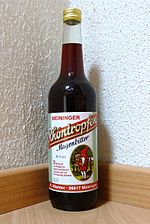
- Rhöntropfen – Magenbitter ist ein seit 1877 in Meiningen hergestellter bekannter Kräuterlikör mit 35% Alkoholgehalt, destilliert mit Kräutern aus der Rhön, Infos: Das Rhön-Dorf
Einkehr
Verpflegung im Mittelgebirge: Einkehrmöglichkeiten außerhalb von Ortschaften.
Berggasthöfe und Wanderhütten mit Übernachtungsmöglichkeit siehe auch im Abschnitt accommodation.
- 1 Fischerhütte Rothsee: Im Sommer tagsüber geöffnet, am Rothsee.
- 2 Kiosk am Schwarzen Moor: Ganzjährig und auch im Winter tagsüber geöffnet. Der Kiosk in Lage an der vielbefahrenen Hochrhönstraße und am Schwarzen Moor ist einer der touristischen Brennpunkte in der gesamten Rhön.
- 3 Milseburghütte: Im Sommer geöffnete Wanderhütte unmittelbar am Gipfel der Milseburg (835 m). Verpflegung und einfache warme Speisen.
nightlife
Im Mittelgebirge selbst gibt es keine allzu großen Möglichkeiten der abendlichen Freizeitgestaltung. Das Rhön-Park Hotel (siehe Kapitel Unterkunft) unterhält seine Gäste in einer Tanzbar.
Eine nennenswerte Auswahl an Kneipen und Diskotheken gibt es im Fränkischen in Bad Neustadt or in Bad Kissingen, im Hessischen in Fulda und im Thüringischen Meiningen.
accommodation
Unterkünfte im Tal siehe bei den Localities.
Ortsferne Einkehr ohne reguläre Unterkunft siehe im Abschnitt kitchen.
Vereinshütten und Unterkünfte für den Wanderer
Die Hütten der Wandervereine bieten preiswerte Verpflegung und Übernachtungsmöglichkeiten:
- 1 Fuldaer Haus (Restaurant, Berggasthof, 670 m; Rhönklub-ZV Fulda), Maulkuppe 1, 36163 Poppenhausen-Steinwand (an der Maulkuppe). Tel.: 49 (0)6658 242. Geöffnet: ganzjährig (außer November); Montag Ruhetag. Direkte Anfahrt möglich;

- 2 Kissinger Hütte (Restaurant, Berggasthof, 832 m, Rhönklub Bad Kissingen), Kissinger Hütte, 97657 Sandberg OT Langenleiten (Berghütte auf dem Feuerberg). Tel.: 49 9701 286. Ausstattung: 21 Schlafplätze im Zimmer, 33 Lager.Geöffnet: ganzjährig; Montag Ruhetag;.
- accommodation at the KreuzbergDas Franziskanerkloster ist auf die Unterbringung von Hunderten von Wallfahrern eingerichtet. Bei Verfügbarkeit bietet es auch anderen Gästen Übernachtungen an.
- 3 Gemündener Hütte: Wanderhütte, Unterkunft nur als Selbstversorger
- 4 Neustädter Haus: Berggasthaus auf dem Käulingberg (ca. 2 km östlich des Kreuzbergs)
- 5 Würzburger Karl-Straub-Haus (825 m, Rhönklub Würzburg), Würzburger Haus, 97779 Geroda (auf dem Farnsberg). Tel.: 49 (0)9749 230. Ausstattung: 13 Zwei- und Mehrbettzimmer mit insgesamt 39 Betten, Etagenduschen.Open: all year round, daily from 10 a.m., closed on Wednesdays.
- 6 Schweinfurt House (Rhön Club Schweinfurt), Schweinfurt House, 97656 Oberelsbach (northeast on Gangolfsberg). Tel.: 49 (0)9774 590. Open: closed on Wednesdays.Direct access via the village of Urspringen and the connecting road to the Hochrhön possible.
- 7 Rother Kuppe hiking home (Restaurant, lookout tower, 711 m, hiking home of the Rhönklub Zweigverein Rother Kuppe e.V.), Tower restaurant "Rother Kuppe", 97647 Hausen (on the Rother hilltop). Tel.: 49 (0)9779 85 02 35. Overnight stay currently only in 2 tower rooms with 2 beds each, with shower / toilet, television.Open: all year round; 11 a.m. - 9 p.m., closed on Mondays. Direct access from Roth possible.
- 8 Würzburger Bergbund Hut (Würzburg section of the German Alpine Club DAV) (at the Sky dunk). Equipment: Self-catering hut with 45 camps. - No direct approach possible. Fastest approaches from Oberweißbrunn (B279) or from the parking lot at the Schwedenschanze (B279 to Gersfeld);
- 9 Meininger Hut (Hiker's hut, 751 m, Rhönklub Meiningen), 98617 Helmershausen, OT Geba, (on the High Geba). 50 seats, overnight stay for self-catering: camp for max. 12 people.Open: open by arrangement.
- accommodation at the Elbow:
- 10 Eisenach house (Mountain hotel, restaurant, cafe, 814 m, private), Frankenheimer Strasse 38, 98634 Erbenhausen, OT Reichenhausen (on the Elbow). Tel.: 49 (0)36946 3600. Open: no day off.. The Eisenach house, built in 1927, began as a hiking hostel of the Rhön Club Eisenach in the years from 1928 to 1945. From 1945 to 1961, the expropriated hiking hut was a vacation home of the then FDGB. From 1963 to 1970 a Soviet listening system was housed here, which was operated by the GDR State Security until 1990. From 1990 the mountain inn was extensively renovated and converted into a seminar hotel.
- 11 Thuringian Rhönhäuschen (Mountain inn, 775 m, private), Frankenheimer Strasse 38, 98634 Erbenhausen, OT Reichenhausen (southwest of the Elbow). Tel.: 49 (0)36946 32060. 5 rooms with 14 beds, shower / toilet;Open: closed on Mondays.. The Rhönhäuschen was built in the twenties as a youth hostel and was then greatly enlarged by the Reich Labor Service as accommodation with 14 barracks. After the end of the war, everything except two buildings was destroyed; in the times of the GDR there was only a simple pub and a youth hostel run by the FDJ. From 1990 the Rhönhäuschen was privately renovated.
various
Local excursion restaurants and private accommodation directly on and in the low mountain range or biosphere reserve of the Langen Rhön:
- 12 Sennhütte: private mountain inn at the border triangle at Fladungen (on Hochrhönstrasse, near the Black Moore)
- 13 Hillenberg (Holiday farm, rooms, youth campground, 680 m private guest house, youth campground of the Rhön-Grabfeld district), Hillenberg 1, 97647 Hausen / Rhön (in the hamlet of the same name). Tel.: 49 (0)9778 1410. Open: all year round.
- 14 Rhoen Park Hotel (Four-star hotel with meeting rooms), Rother Kuppe 2, 97647 Hausen-Roth. Tel.: 49 (0)9779 910, Fax: 49 (0)9779 911840, Email: [email protected].
- 15 Thuringian hut (Mountain inn, excursion restaurant, rooms, 690 m, private), 97647 Thuringian Hut. Tel.: 49 (0)9779 562. Open: all year round from 10 a.m. to 6 p.m., closed on Tuesdays in winter (except when skiing).
- 16 Holzberghof hunting lodge, private mountain inn Bischofsheim on the connecting road Fladungen (Hochrhönstrasse), below the Heidelstein
- 17 Rhönhäuschen, private mountain inn on the approach road Bischofsheim to the Red Moor (B 278)
- 18 Berghaus Rhön (Excursion bar, beer garden), Bergseestr. 99, 97792 Riedenberg. Tel.: 49 (0)9749 244. Open: closed on Tuesdays. The mountain house is located in the local recreation area Farnsberg (Basaltsee Farnsberg), the building was built in 1932 as a canteen for the workers in the basalt mining industry.
security
climate
_im_Nebelmeer.jpg/250px-Kreuzberg_(Rhön)_im_Nebelmeer.jpg) Kreuzberg, Arnsberg and Black Mountains above the sea of fog in late autumn |
 Thunderstorm mood |
An age-old saying of the locals reads: "In the Rhön it is 3/4 year winter and 1/4 year cold", this only applies to a limited extent to the low mountain range, even in today's times of global warming.
The Rhön is a weather divide. The low pressure areas approaching from the north accumulate on the Hessian side of the Rhön, with the corresponding rainfall. In contrast, the south side (district of Rhön-Grabfeld) in the slipstream of the Rhön is considered the "Sahel zone" of Bavaria in the already dry Franconia.
A constant wind blows on the plateaus of the Rhön. Due to the lack of forest, a storm can fully attack the unprotected individual trees here, so that large, free-standing trees are very rare and then develop a correspondingly gnarled shape with the wind damage that has been experienced over time. Wood breakage caused by snow and frost in winter does the rest.
The snow sometimes lingers in shady depressions on the plateaus until May. In summer, the Rhön offers an airy cooling off from the heat in the lowlands, and in late autumn, when the highest peaks tower above the high fog, magnificent moods and distant views. The thunderstorms and storms of the Rhön are feared because of their intensity. A few times a year there is also a real hair dryer with "cloud roller" over the mountains and the correspondingly clear warm air on the south side of the Rhön.
The climate in the Rhön (800-900 m) is altogether quite comparable with the alpine climate in the altitude regions of approx. 1400 m and should be taken into account when choosing clothing. It is really warm in summer on the high Rhön only on a few days.
| Climate of Wasserkuppe | Jan | Feb | March | Apr | May | Jun | Jul | Aug | Sep | Oct | Nov | Dec | ||
|---|---|---|---|---|---|---|---|---|---|---|---|---|---|---|
| Mean highest air temperature in ° C | -1.2 | -0.5 | 2.4 | 7.0 | 12.3 | 15.1 | 16.9 | 16.9 | 13.6 | 9.2 | 3.1 | 0.0 | O | 7.9 |
| Mean lowest air temperature in ° C | -5.3 | -5.1 | -2.6 | 0.5 | 4.9 | 8.0 | 9.7 | 9.8 | 7.2 | 3.7 | -1.3 | -4.3 | O | 2.1 |
| Precipitation in mm | 82 | 64 | 79 | 84 | 97 | 115 | 109 | 100 | 82 | 81 | 88 | 104 | Σ | 1085 |
| Rainy days in the month | 22 | 18 | 15 | 17 | 16 | 16 | 17 | 16 | 16 | 16 | 19 | 19 | Σ | 207 |
| Relative humidity in% | 91 | 88 | 87 | 80 | 77 | 80 | 79 | 80 | 85 | 86 | 91 | 91 | O | 84.6 |
| Length of sunshine per day | 1.7 | 2.6 | 3.4 | 4.8 | 6.4 | 6.3 | 6.8 | 6.2 | 4.7 | 3.9 | 1.8 | 1.7 | O | 4.2 |
Source:Wetterkontor | ||||||||||||||
Practical advice
Information centers to the Rhön:
- in the Wildfleckener The Oberbach district is where the information center is located House of the Black Mountains.
- In Oberelsbach is the information center House of the long Rhön to the UNESCO Biosphere Reserve Rhön.
- On the Wasserkuppe is that Wasserkuppe information center the Hessian administrative office for the Rhön Biosphere Reserve.
- In Zella is the Thuringia administration of the Rhön Biosphere Reserve: Rhön Biosphere Reserve Administration Thuringia, Propstei Zella Goethestrasse 1, 36452 Zella / Rhön. Tel.: 49 (0)36964 8683-30.
Spa and bonus cards the Rhön:
- The tourist bonus card has been available in the Rhön since November 2015 Rhön Pass to buy. With this you get discounts, free admission or free gifts from various partners for three months. The Rhön Pass can be purchased online and at various sales points in the Rhön.
trips
- In the surrounding Low mountain range: these are Thuringian Forest With Oberhof and the Rennsteig, to the Vogelsberg, in the Spessart with the Wasserschloss Mespelbrunn, and into the neighboring one Grave field;
- To Main Franconia to Franconian wine and Franconian cuisine;
- In the near CitiesEisenach, Fulda, Schweinfurt, Wurzburg, Bamberg, Coburg and Suhl;
- To the basilica built by Balthasar Neumann Fourteen saints and Banz Monastery in the upper main valley;
literature
General
- Schneider's Rhön leader, official guide of the Rhön Club, current edition: 05/2006, Verlag Parzeller, Fulda, ISBN 3-79000-365-4 ; 498 pages; Price: 10.- €; Most content-rich reference work on the "land of the open distant";
- "Through the Rhön", an illustrated reader with articles by various well-known authors, published by the Rhönklub e.V .;
- 272 pages; Verlag Parzeller Fulda, 2001; 19.50 euros; ISBN 3-790-0327-1;
- "and go up to the Rhön - forays through a biosphere reserve", the Hessian Nature Conservation Foundation presents the landscape and nature of the Rhön with the help of pictures and appropriate texts
- 96 bound pages; 131 color photos, specialist publisher Dr. Fraund; ISBN 978-3-921156-79-7
nature
- : The Rhön - the fascination of nature. 2009, ISBN 978-3-86568-349-6 ; 160 pages. Illustrated book on the beauty and diversity of the Rhön / habitats and animal species; Price: € 24.95
- : Orchids in the Rhön. Rhön Publishing House, 2009, edition alpha, ISBN 978-3-941987-01-2 ; 256 pages. more than forty species of wild orchids; Price: € 23.90
- : Northern Rhön: steep walls and open shapes. Forays through the history of the earth. Quelle & Meyer Verlag, 2008, ISBN 9783494014647 ; 134 pages. geological and paleontological guide for the interested layperson, price 14.95 €
Culture
- : Northern Rhön: On ancient paths through prehistory and early history. Quelle & Meyer, 2014, ISBN 978-3494015446 ; 232 pages. € 16.95. In the style of a hiking and cultural guide, two experts treat the monuments between the Lüder and Feldatal valleys in an easy-to-read form.
- : In the footsteps of the Celts in the Rhön: From the Werra to the Fulda and the Franconian Saale. Petersberg Imhof, 2009, ISBN 9783865685117 ; 120 pages. The richly illustrated book describes the Celts and where they lived on the mountains, slopes and valleys of the Rhön. Price: 19.95 €
- "The saga of the Franconian region" and "The sagas of the Rhön Mountains and the grave field", edited by Ludwig Bechstein, Voigt and Nocker, Würzburg (1842), reprint in September 1979 by Rainer Hartmann, Sondheim v. d. Rhön --- in the antiquarian bookshop.
- Elke Böhm, "Masks", folk art and customs of the Rhön; Universitas 2002; ISBN 3-8004-1446-5 ;
- "Mysterious masks" from the Rhön, by Jewish and Christian beard men; Catalog for the exhibition of the Hessisches Landesmuseum Darmstadt in 2005; ISBN 3-926-527-74-9 ;
Hiking guide
- : Experience Rhön plants while hiking. Mack, 2013, ISBN 978-3-939597-02-5 ; 198 pages. five hiking tours present the typical flora of the Hochrhön; Price: € 17.95
- Hiking trails through the Rhön, by Günter Rinke; Publisher: RHOENKLUB e.V. Descriptions of all long-distance hiking trails through the Rhön with map sketches;
- 201 pages, Michael Imhof Verlag Petersberg; 9.95 euros; ISBN 3-937251-77-4 ;
- "On easy ways through the country"; small guide through the Rhön with 35 hiking suggestions for wheelchair users, older visitors and families with children; available from the office of the Rhön Club and the tourist offices;
- Jürgen Reinhardt, "Rhön", Bergverlag Rother (2005); 10.50 euros; ISBN 3-76334182X ;
- Stefan Etzel: "Hiking in the Rhön" - 35 tours, exact map, elevation profiles; Dumont Reiseverlag (2010); 12.95 euros; ISBN 978-3-7701-8025-7 .
cards
The official cards of the Rhön Club:
- Topographic map of the Bavarian Rhön Nature Park, sheet south, 1:50 000, Bavarian State Surveying Office sheet UK L 14 ISBN 3-86038-490-2 ;
- Topographic map of the Hessian Rhön Nature Park, North Sheet, 1:50 000, Hessian Land Surveying Office, ISBN 3-89446-313-9 ;
Other cards:
- Kompass hiking and biking map Rhön, WK 762; 1:50,000; ISBN 3-85491-536-5 ;
Web links
- Official site of the Rhön Nature Park: www.naturpark-rhoen.de;
- Internet portal for the Rhön www.rhoen.de;
- Portal of the Regional Forum Thuringian Rhön: www.thueringerrhoen.de;
- Rhön Biosphere Reserve: brrhoen.de;
- Rhön Club: www.rhoenklub.de;
- Excursion guide to selected geological objects in the Thuringian Rhön: PDF (at the biosphere reserve);
- All stages of the Hochrhöner Premium Trail www.rhoenfuehrer.de;
- Web links to the Hochrhöner Premiumweg www.equisetites.de;