 | ||
| Wasserkuppe | ||
| federal state | Hesse | |
|---|---|---|
| Residents | unknown | |
| no value for residents on Wikidata: | ||
| height | 950 m | |
| no tourist info on Wikidata: | ||
| location | ||
| ||


At 950 m it is Wasserkuppe, the mountain of the aviators, the highest mountain Hessen and the Rhön. The much-visited survey is worth a visit at any time of the year. The mountain touches the Hessian communities Gersfeld (Glider Museum, Fulda Spring, Summit) and Poppenhausen (Wasserkuppe).
Although about 30 streams arise on the mountain, the name does not come from the abundance of water on the mountain. The name Wasserkuppe probably goes back to the Middle High German word "Wass", which describes a pasture.
background


Gliding
The Wasserkuppe is the cradle of gliding: in 1910, Darmstadt high school students carried out their first flight experiments, and in 1912 they achieved the first world record flight with a distance of 850 meters.
The first gliders were started with a catapult made of rubber ropes, but mostly had to land again after a short flight. But as early as 1922 Arthur Martens with a glider launched from a horse's head on the Wasserkuppe, it was 66 minutes in the air above the Wasserkuppe, a world record back then as the very first motorless hourly flight; the flight distance of 8.9 km and 108 m take-off elevation were two further world records of this legendary flight. Martens then founded the world's first gliding school on the Wasserkuppe.
In April 2014, the soaring flight on the Wasserkuppe was therefore nominated for the state of Hesse and against four competitors as a contribution to the UNESCO Intangible Cultural Heritage. In autumn 2015 the decision will be made as to whether the Wasserkuppe will be nominated as a German contribution to the international list.
getting there
In the street
- Of Fulda: Bundesstrasse 458 via Dipperz to Dietges. From Dietges via Abtsroda steeply up to the Wasserkuppe.
- from the south: - A 7 to junction Bad Bruckenau/ Wild spots. We continue on state roads in the direction of Wild spots. In Oberweißbrunn on the B 279 direction Gersfeld switch. From Gersfeld via the B 284 up to the Wasserkuppe.
- 1 parking spot , 2 parking spot, 3 parking spot and 4 Fulda-Quelle car park. GPS: Wasserkuppe, 36129 Gersfeld (Rhön)
By train
- With the long-distance train to Fulda. Then with the Rhönbahn (HLB - Hessische Landesbahn) in fully air-conditioned, modern railcars, type Alstom Coradia-LINT, approx. 40 minutes to Gersfeld. Incidentally, there is a chance to recharge your mobile phone, notebook, tablet PC or other technical companion, as all seating areas are equipped with 230 V sockets.
- The bus line 37 (RMV tariff) to the Wasserkuppe and back has been running regularly from Gersfeld since 2012.
- From Gersfeld you can hike up to the Wasserkuppe in around one and a half to two hours (approx. 450 m difference in altitude).
On registration A minibus also drives from Gersfeld (no RMV tariff) to the Roten Moor and Wasserkuppe. The timetable of the hiking bus is here to find (valid from April to November).
In the winter half year runs on the same line on pre-order a ski bus. The timetable is on here in the web.
By bus
- From Gersfeld and Poppenhausen bus line 37 runs (RMV tariff)
- From the central bus stop in the area of the Fulda Central Station bus line 35 runs from Mon to Sat directly to the Wasserkuppe. The stop is called in the electronic timetable information of the RMV "Gersfeld (Rhön) -Obernhausen Wasserkuppe". In the travel information of Deutsche Bahn, the stop is somewhat more simply called "Wasserkuppe, Gersfeld (Rhön)". The bus stop on the Wasserkuppe is in the parking lot "P 5" 50 ° 30 ′ 0 ″ N.9 ° 56 ′ 56 ″ E to find.
- - The departures from "Fulda ZOB" (= bus station at the main train station in the RMV timetable information) are on weekend 10:10 am, 12:10 pm, 2:10 pm and 5:10 pm (travel time 49 minutes; different times on weekdays).
- - From the Wasserkuppe it goes back to Fulda at 11:14 a.m., 1:14 p.m., 3:14 p.m. and 6:14 p.m. (different times on weekdays).
- - Single trip: adults € 4.10, children € 2.45 (6-14 years). A group day ticket for up to 5 people is worthwhile for 2 adults or more; Data status 01-2012 according to RMV information). Important: travel times can vary. B. sometimes change at short notice due to construction sites and timetable changes, so it is best to always look it up again.
- Rhön bike bus: The leisure bus line with free bike transport (RMV tariff) also runs on a different route in the summer half-year from May 1 to October 3, 2011 on Sundays and public holidays. The bus runs from Fulda along the Milseburgradweg to Hilders, then up along the Ulstertal cycle path, further up to the Wasserkuppe and back down to the Gersfeld train station. There is a connection to the Rhön Railway to Fulda. Further information: · Location plan · Timetable 2011 · www.lng-fulda.de
mobility
There are several large parking spaces in the summit area. But on nice winter days they can all be occupied. This is then pointed out in the traffic radio. The "Fuldaquelle car park" on the upper southern slope of the Wasserkuppe provides an ID card.
However, you have to complete the summit tour on foot.
Tourist Attractions

Radome
1 Radome The landmark of the Wasserkuppe, visible from afar, was not demolished after the end of its military use, but made accessible to the public. However, there were controversial discussions about the preservation of the building. The Radom is now operated by a non-profit operating company, RADOM-Flug gGmbH. Radom (radome) can be translated from "Radar Dome"or from the German of"Rarepresent Domizil can be derived.

The building can be opened daily within the framework of guides (PRE-REGISTRATION REQUIRED!). The building with the large domed hall and viewing platform will be visited. Admission to guided tours: Adults: € 5.00; Pupils, students, pers. with disability ID: € 2.50, children: up to 6 years are free. Special prices are offered for school classes. Booking contact: (Info). In good weather, on Saturdays, Sundays and statutory Public holidays, the RADOM by volunteers from RADOM-Flug gGmbH, open to visitors. Visitors can then walk around the building independently and visit the viewing platform, domed hall, and the history exhibition in the staircase and the base hall. Admission to the tour is € 4.00 for adults, reduced € 2.00 and children up to 6 years old are free. You can find out whether it is open from the Rhön Info Center or by displaying flags in the area of the access road (L3086) and on the summit circular path along the high plateau.

Furthermore, the Viewing platform Accessible during the day in the form of the 65 m long panorama circuit (entry 2 euros via coin slot). Whoever stands here has reached the highest publicly accessible point in Hesse.
The domed hall of the radome was redesigned into a multifunctional room after the dismantling of the radar device. This can be used for exhibitions or concerts (due to its spherical shape, the radome has unique and impressive acoustics). The RADOM can also be rented as a venue for company parties or other events. Another special feature is the possibility of getting married here. The RADOM is a branch of the Gersfeld registry office. Further information on Hesse's highest cultural monument: www.radom-wasserkuppe.de
German Glider Museum
2 German Glider Museum Since the spring of 2006, the German Glider Museum on the Wasserkuppe has been documenting the over 100-year history and development of gliding in an exhibition hall covering around 4000 m². The exhibition ranges from simple Lilienthal gliders to modern high-performance plastic gliders. The collection consists of full-size gliders as well as model airplanes of significant developmental history.

Opening hours:
- - Summer season (April 1st to October 31st) Daily of 10:00 a.m. to 5:00 p.m.
- - Winter season (November 1st to December 19th and January 11th to March 31st) Saturday / Sunday from 10:00 a.m. to 5:00 p.m.
- - Turn of the year (December 20th to January 10th) Daily of 10:00 a.m. to 5:00 p.m. closed on December 24th and 31st
- Entry:
- - Adults individual € 5.00, groups of 15 or more - € 4.00 per person
- - Schoolchildren, children, students, trainees € 3.00 Groups of 15 or more - € 2.00 per person
- - Family card, parents with children (children under 6 years are free) € 12.00 Guided tours are offered after registration.
- Contact: German Gliding Museum Foundation with model flight, Wasserkuppe 2, 36129 Gersfeld (Rhön), Tel .: 06654/7737 Segelflugmuseum.de
UNESCO information center in the Groenhoff House
1 Groenhoff House with information center of the Rhön Biosphere Reserve The information center of the Rhön Biosphere Reserve shows an exhibition on the history of the Rhön Biosphere Reserve, which was founded in 1991. There are also multi-vision shows and films for the Rhön and its wildlife. In the regional shop "Rhöner Durchblick" you can buy regional specialties from the Rhön. Guided tours are available for groups by appointment. Furthermore, specialist lectures and events are offered (see also Calendar of events of the biosphere reserve).
- Opening hours:
- April 1 to November 1: daily 10 a.m. - 6 p.m. (Fri only until 4 p.m.)
- November 1 to November 30: Mon to Thu: 10 a.m. - 4:30 p.m. Fri 8:30 a.m. - 1 p.m.
- December 1 to March 1: daily 10 a.m. - 4 p.m.
- In March it will be closed (?)
- Contact Rhön Biosphere Reserve, Groenhoff-Haus, Wasserkuppe No. 8, 36129 Gersfeld, Tel .: 06654 / 9612-0 Status 10-2011
More Attractions
- Panoramic views over the Rhön from the summit circular path to the Radom z. B. at 3

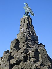
- 4 Aviator memorial - the monument was built in 1923. It commemorates the pilots who died in the First World War. (see also article "Fliegerdenkmal (Wasserkuppe)" at Wikipedia)
- 5 Model flight slope above the Fulda spring
- The 6 Fulda spring lies south of the summit plateau on the road to Gersfeld or Ehrenberg; There is a parking lot directly at the source


activities

Walks and hikes
Attractive hiking destinations from the Wasserkuppe are:
- 7 Summit circular route to the Radom - Route: information center or glider museum - toboggan arena mountain station - Radom (quasi summit of the Wasserkuppe) - from here detour to the aviator memorial - back past the youth education center. The round, including the detour to the aviator memorial, is around 2.5 km long. There are numerous beautiful views on the route.
- 8 Horse head - the 875 m high basalt cone is located in front of the Wasserkuppe to the southwest (location 50 ° 29 ′ 29 ″ N.9 ° 55 ′ 16 ″ E). From the rocky summit there is a view of the valley. Distance from the information center at the glider museum about 2.5 km one way).
- 1 Rotes Moor with observation tower on the jetty and 2 Heidelstein with a west view of the Wasserkuppe - The Red Moor can be reached via a partly scenic high path past the Fulda spring. The route length is about 5.5 km one way (information center at the glider museum to the moor lake). If you feel like it, you can walk from there via the house to the Rotem Moor (refreshment stops) to the Heidelstein with its transmitter mast. Then just add another 2 km up to the mountain. Up here you can enjoy a wide panoramic view to the east, south and west. The Wasserkuppe can also be seen. Warning: the route is not suitable for pushchairs. The scenic forest path between the Fulda spring and the B 284 is quite rocky and bumpy and cannot be driven with a stroller.
Winter sports

- Alpine skiing - More information about the "Wasserkuppe-Abtsroda" ski area can be found in the article Winter sports in the Rhön to find.
- Nordic skiing - On the Wasserkuppe, circular trails are groomed on the airfield. For those who are in good shape, there is a ski hike on the high-altitude trail to the Red Moor. The easy, panoramic high-altitude trail leads over 6 km to the Haus am Roten Moor (refreshment stops). On the way you can make a detour to the moor walkway with a lookout tower.
- 9 Wasserkuppe tobogganing arena There are two 700 m long sheet metal toboggan runs. The ascent takes place with a ski lift. There is also the Rhönbob. The toboggan run on steel rails is 1000 m long. Contact: www.sommerrodelbahnen-wasserkuppe.de, Tel .: (06654) 632
further activities
- Enjoy the sunset below the radome - Here there are tables and benches from which you can enjoy the west view with sunset.
- 10 Flying school "Papillon": hang gliding and paragliding with the Flying School "Papillon" Tel.: (06654) 7548
- 11 Start of the sightseeing flights
- Wasserkuppe flying school, Wasserkuppe 1A, 36129 Gersfeld. Tel.: 49 (0)6654 364. In addition to the training, there is also the possibility of sightseeing flights with the glider, motor glider, ultralight.

- 1 Language experience camp Wasserkuppe, Wasserkuppe 10, 36129 Gersfeld. Tel.: (0)6654-2849944. . For teachers there is the possibility of support from the "RhönGuides - professional companions for school trips on the Wasserkuppe ".
- Model flight - There are a total of five slopes on the Wasserkuppe from which model sailors and airplanes are allowed to take off. The model flight slope "Pelzener Hang" is z. B. above the Fulda spring 12 . If you feel like it, you can watch the "little gliders" on their elegant flights. But these also have a span of two meters. Information about the Model flight of the Wasserkuppe flying school.
shop
In the summit area there are, among other things, several "tourist shops" that offer the classic range. In addition to small souvenirs, you can also buy farmhouse bread and sheep sausages here. In the flight center, the company Gleitschirm Direkt offers a wide range of products for everything to do with paragliding.
kitchen
Various restaurants are available on the mountain.
- 1 Märchenwiesenhütte. Recommended for those on a tight budget at the summer toboggan runs. It offers simple inexpensive dishes.
- 2 Bistro Waldfrieden. Located on the way to the summer toboggan run.
- 3 Self-service restaurant Deutscher Flieger
 in the Wikidata database")
- 4 Peterchen's trip to the moon. upscale cuisine.
accommodation
There are some accommodations directly on the mountain:
The next larger places to stay are Gersfeld, Ehrenberg (Rhoen) as Poppenhausen (Wasserkuppe).
security
The Mountain Rescue Service Wasserkuppe helps with accidents in winter or aviation.
trips
- Hike to the Red Moor (approx. 5 - 6 km one way). In winter this route will also be a beautiful one Groomed high-altitude trail.

Practical advice
- Rhön Info Center (Tourist office), Wasserkuppe 1, 36129 Gersfeld (centrally directly opposite the glider museum). Tel.: 49 (0)6654 918340. barrier-free entrance,Open: Tue - Sun: 10 a.m. - 4 p.m., closed on Mondays.
- Wasserkuppe information center (Hessian administrative office for the Rhön Biosphere Reserve, UNESCO information center), Groenhoff-Haus Wasserkuppe 8, 36129 - Gersfeld. Tel.: 49 (0)6654 96 12 - 0.
- Toilet - The modern one chargeable The toilet is in the building opposite the Rhön Info Center. The access is to be found at the rear at the side. There is a coin turnstile at the toilet. Fee: 20 cents. Good to know: The machine also accepts 10-cent coins (but not 1, 2 or 5-cent coins).
climate

The Wasserkuppe has a very harsh climate. According to the German weather service, the annual average temperature is just 4.8 degrees Celsius (value is, for example, 8.0 degrees Celsius in Fulda, which is only 255 m above sea level).[1] About 1083.5 mm / m2a precipitation falls on the mountain each year. That is significantly more than in the Rhön foothills. Fulda, for example, has only about 664 mm / m2a of precipitation annually.[2]
Between the end of November and the beginning of March, an average winter usually has the mountain firmly under control. Sometimes the snow even lasts until the end of March and the beginning of April (e.g. in the exceptional winter of 2008/2009). Between mid-February and early March there can be between 1 and 1.2 meters of snow on the Wasserkuppe.
Weather forecast
- A 4-day forecast for the Wasserkuppe can be found at Meteomedia AG.
- Note for winter sports enthusiasts: You can calculate the amount of new snow that is likely to be expected from the forecast yourself. Rule of thumb: 1 mm of precipitation results in about 1 cm of cardboard snow (at temperatures around 0 degrees Celsius). Powder snow usually falls at lower temperatures. Here 1 mm of precipitation results in 1 - 2 cm snow depth, as the snow is looser.
- Current snow depth on the Wasserkuppe via Wetteronline.de
- A forecast for the "Rhön" region is up to 6 days in advance is found on Weather Online. The 3-day forecast appears. A trend for up to 6 days in advance can be obtained by clicking on "Trend" in the table below. The forecast relates to an altitude of 800 m.
literature
- Description of the Rhön: see article Rhön
- A practical overview plan of the summit area of the Wasserkuppe is available free of charge from the information center.
- Winter sports card of the Rhön: Scale 1: 50000; Price: 4 euros (in the 2008/2009 season). The map is available from the local tourist information offices. It can also be purchased at the tourist information on the Wasserkuppe, in the Haus am Roten Moor and in the Haus am Schwarzen Moor. The map is particularly helpful for cross-country skiers who are planning longer tours in the Rhön.
Individual evidence
- ↑Germany-wide table of mean annual temperatures from the DWD; annual mean value for the Fulda and Wasserkuppe stations between 1961 and 1990 (to be found under www.dwd.de -> climate environment)
- ↑Germany-wide table of mean precipitation from the DWD; annual mean value for the Fulda and Wasserkuppe stations between 1961 and 1990 (to be found under www.dwd.de -> climate environment)
Web links
- official tourism website of the Rhön - There is an information center on the Wasserkuppe
- rhönführer.de - Entry of the Wasserkuppe on rhönführer.de
- Rhön Biosphere Reserve
Webcams
- Rhönblick at the Wasserkuppe - Camera of the Wasserkuppe glider school
- different cameras - i.a. Street view in the summit area and landscape view from Sieblos to the western slopes of the Wasserkuppe with a horse's head