The Vogelsberg is located in the East Hessian mountainous region. Are adjacent Taunus, Wetterau, Schwalm, Crunch, Rhön, Spessart and the Rhine Main Area. Bounded by the four motorways (A45, A5, A7 and A66), the rural region is about 50 km northeast of Frankfurt am Main. The low mountain range is an extinct and now eroded volcano with a diameter of around 60 kilometers.
In the mountains there are numerous leisure activities such as hiking, trekking, cycling and the summer toboggan run, as well as alpine skiing and Nordic skiing in winter.
Regions
- Oberwald - The Hohe Vogelsberg with the Baptismal font and Hoherodskopf
- Lautertal
- Feldatal
- Schwalmtal
- mosquito
- Niddatal
places

- 1 Alsfeld


 in the Wikidata database") - Half-timbered old town
- Half-timbered old town - 2 Birstein - worth seeing lock
- 3 Gedern - Lock; Leisure area "Gederner See"
- 4 Herbstein - thermal bath; geographical center of the old Federal Republic
- 5 Lauterbach (Hesse) - Old town with half-timbered buildings; northern entrance to Volcano bike path
- 6 Ortenberg (Hesse) - Old town with half-timbering
- 7 Bulkheads - historic half-timbered old town
- 8 Ulrichstein - Castle hill with "observation box"
- 9 slot - Half-timbered old town


background

Contrary to what the name suggests, the Vogelsberg is not a single mountain, but a mountain range of volcanic origin with several peaks that gather on the Hohen Vogelsberg at an altitude of over 700 meters. Politically, most of the Vogelsberg belonged to the Grand Duchy of Hesse, where the Vogelsberg was already known as Hessian Siberia because of its poor transport connections (the roads were not paved until the 1960s) and the harsh climate. But also the Südvogelsberg with the communities Birstein and Brachttal, which politically belonged to the Electorate of Hesse and later to Prussia, forms a culturally unity with the rest of the Vogelsberg.
The Vogelsberg is used intensively for agriculture, although climatically and in terms of the soil conditions hardly suitable for this, it is therefore comparatively bare and poorly forested, unlike most other German low mountain ranges. The seclusion has not changed to this day, the Vogelsberg is extremely rural with many very small villages away from the national traffic routes. Apart from the Hoherodskopf as a tourist hotspot, the Vogelsberg is largely undiscovered and therefore ideally suited for those who are looking for peace and quiet away from the tourist hustle and bustle.
Arrival and mobility
- Car: The entire mountain range is well served by roads. The mountains can be reached quickly via the nearby motorways. The parking spaces in the Hohe Vogelsberg (Hoherodskopf / Taufstein and Herchhainer Höhe) are no longer all free. In winter there can be bottlenecks on nice days.
- Public transport: In the summer months there is an exemplary network of leisure bus routes with bike transport on Saturdays, Sundays and public holidays. The different lines meet in a star shape at the Hoherodskopf. More information: see VGO.de · Vulkan-Express-Linien: route network map, 2012 timetables and brochure with lots of leisure tips
- bicycle: The Vogelsberg is a low mountain range that is well developed for cyclists. Paradeweg is 94 km long Volcano cycle path, which connects Altenstadt with Lauterbach and Schlitz. 65 km of the continuously paved and largely traffic-free path run along the route of the former Oberwaldbahn. There are also other paths that open up the mountains (Vogelsberger Südbahnradweg or. Hoherodskopfsteig). The Hessian long-distance cycle route R4 also runs over the mountains.
- motorcycle: "Route 276" is interesting for motorcyclists, a winding federal road through the Vogelsberg.
Tourist Attractions
- Hoherodskopf: Summer toboggan run, various gastronomy, star point of the bicycle bus routes,
- Winter: In winter, two drag lifts are in operation, extensive network of trails;
- Summer: In summer, the summer toboggan run offers pure adrenaline for young and old
- Conservation information center - Exhibition on flora, fauna and geology of the mountains, tourist information, opening times: Mon - Fri 11:00 am - 5:00 pm; Sat, Sun and on public holidays 10:00 am - 5:00 pm; Tel .: 06044-9669330; Admission: the exhibition is accessible free of charge (data status 03-2007)
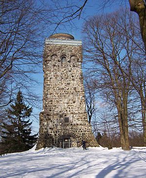
- Baptismal font: 773 m Highest elevation of the mountains; Bismarck Tower (accessible free of charge)
- Herchenhainer height: From the southernmost "observation box" of the mountains you have a beautiful view of the Rhön, Spessart, Rhine-Main area, Taunus and Wetterau. From the top you have a beautiful panoramic view to the south. The best way to do this is from the car parking lot 50 ° 29 ′ 4 ″ N.9 ° 16 ′ 29 ″ E across the meadow to the edge of the forest up to 720 m high. Up here at the entrance to the monument (located in the forest) you will find two benches, each with a table, as well as a photo panorama that explains the wide 180-degree panoramic view. Gastronomy and a ski lift are available in the area of the parking lot.
- Hohaus Museum in the baroque palace Hohhaus in Lauterbach.
- Romrod Castle in Romrod - The castle emerged from a water castle that was built at the end of the 12th century. In the 16th century it was expanded into a hunting lodge and the official residence of the Landgraves of Hesse. In 1996, the German Foundation for Monument Protection converted the castle into an educational institution of the Monument Academy and a hotel with a restaurant.
Tel .: 06636 - 918 1914, Schlossallee 1, Bus: VB-14, VB-15 (Mon - Fri) "Romrod Church".
mountains
- Baptismal font 773 m
- Hoherodskopf · 764 m
- Breungeshaimer Moor with Nidda spring and Geiselstein; the only raised bog on the Vogelsberg
- "Bilstein" rock cliff - 666 m high basalt rock south of Breungeshain (near 50 ° 29 '46 "N.9 ° 12 '11 "E).
- Schlossberg with Vogelsberggarten in Ulrichstein - From the small mountain cone you also have a beautiful view to the west and north.
- Museum of Rural Heritage, Agriculture, Forestry and Hunting in Ulrichstein
activities
To go biking
The Vogelsberg has an excellent network of regional and national bike routes, which is accompanied on weekends by an extensive tourist bus network with bike trailers. Here are the most important routes:
- Volcano bike path - The volcano cycle path takes its name from the Vogelsberg, but also reaches the Wetterau.
- Vogelsberger Südbahnradweg - Completely paved feeder road from Kinzigtal near Wächtersbach in the high Vogelsberg. The path is often referred to as the railway line cycle path, although only a few kilometers of the route run on the route of the former Vogelsberger Südbahn.
- Hoherodskopfsteig - Signposted connection to the Hoherodskopf (Star point of the tourist bus network with bicycle trailers) Direction:
- Ulrichstein (to R4, direction Alsfeld)
- Schotten (to the R4, direction Wetterau) and
- to Hartmannshain (connection Vulkan-Radweg and Vogelsberger Südbahnradweg).
- Hess. Long-distance cycle route R4: From Sleeping Beauty to the Nibelungs - The route crosses the Vogelsberg from Alsfeld coming over Ulrichstein and Bulkheads Direction Wetterau and the Rhine-Main area.
- Hess. Long-distance cycle route R7: From the Werra to the Lahn - Establishes the connection to the volcano cycle path near Lauterbach from Fulda.
see also: regional cycle routes in Vogelsberg and Wetterau
hike
The Vogelsberg offers beautiful hiking opportunities. An interesting "standard hike" in the mountains is the Höhenweg in the Oberwald from Hoherodskopf or Taufstein (2 1/2 hours walking time, see article for information) Baptismal font). The Boniface route from Mainz to Fulda also crosses the Vogelsberg. Information on the pilgrimage can be found on the association's website "Bonifatius Route e.V." to find.
Further information on hiking in the region:
- Vogelsberg volcano ring - The 125 km long circular route was opened in 2004 and leads to the most beautiful destinations in the Vogelsberg.
- Extratouren-vogelsberg.de - Official hiking website from Vogelsberg Touristik with hiking suggestions. The GPS data of the routes can be downloaded for free.
- Hiking club Vogelsberger Höhenclub e. V. - Information on the regional hiking trails that the association looks after as well as hiking suggestions.
Winter sports
There are 3 ski lifts and 55 km of trails; further see article Winter sports on the Vogelsberg
Swimming
miscellaneous
- Trekking tours with llamas and donkey in the Vogelsberg (info)
kitchen
- Vogelsberger salt cake - a bacon cake baked with potatoes, onions and salt.
security
It is not necessary to follow special instructions. As everywhere, the bike should be connected and valuables should not be left in the car. Signs in the Oberwald sometimes warn of ticks.
climate
The climate in the high Vogelsberg is cool and temperate (lots of rainfall). In summer you can escape the humid heat of the Rhine-Main area here. In the cold season, the Vogelsberg is relatively snow reliable in the high areas. In winter 2005/2006 there was up to 70 cm of snow here until March.
Practical advice
- Region Vogelsberg Touristik GmbH, Vogelsbergstrasse 137a, 63679 Schotten Tel .: 06044 - 96 48 48, Fax Tel .: 06044 - 96 48 49, E-Mail: [email protected], Vogelsberg-Touristik.de
trips
Numerous historic towns and cities invite you to visit in the vicinity of the Vogelsberg. For example Alsfeld and slot with its historic half-timbered old towns or the cathedral city Fulda.
Whoever feels like it can do that too Crunch, the northern neighboring mountains.
literature
Hiking map:
- Topographic leisure map "Vogelsberg - Wetterau" 1: 50,000, € 9.50
- Topographic leisure map # 4 "Hoher Vogelsberg" 1: 25,000, € 9.50
- Topographic leisure map # 5 "Südlicher Vogelsberg" 1: 25,000, € 9.50
Cycling maps:
- ADFC regional map "Vogelsberg" 1: 75000 - see Bielefelder Verlag
- Cycling atlas "Wetterau - Vogelsberg" 1: 50000 - see Esterbauer publishing house
Landscape and nature:
- The Vogelsberg - land of hedges - land of springs, Hessian Nature Conservation Foundation, 88 bound pages, 155 color images, ISBN 978-3-921156-70-4 , published for € 13.50 by the specialist publisher Dr. Fraund