The western Franconian Forest is the part of the nature park Franconian Forestwho is in the county Kronach lies. Also a small part of the district Kulmbach can be counted. The area is ideal for hiking and mountain biking. In the small towns and villages that are well worth seeing, you can find overnight accommodation and hearty snacks. On rainy days, you can visit a museum or the tropical house in Tettau. If you want action, book a raft trip on the Wilder Rodach.
places

- 1 Kronach


 in the Wikidata database") - Largest city in the Franconian Forest, on the railway line from Lichtenfels to Saalfeld located, with the fortress Rosenberg.
- Largest city in the Franconian Forest, on the railway line from Lichtenfels to Saalfeld located, with the fortress Rosenberg. - 2 Küps - is known for its high density of castles, there are eight castles for every 8,000 inhabitants in the municipality.
- 3 Ludwigsstadt - is located north of the mountain ridge and north of the Rennsteig hiking trail.
- 4 Mitwitz - market town west of Kronach; Moated castle with adjoining park.
- 5 Marktrodach - with the rafting museum


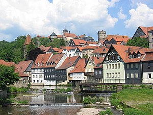
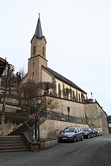
Three-tier city structure of Kronach above the Haßlach river with Rosenberg fortress

Küps

Ludwigsstadt

Mitwitz moated castle


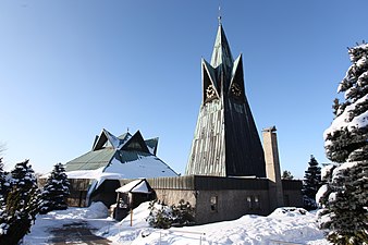
- 6 Nordhalben - Market place with traditional lace making.
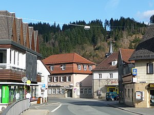
- 7 Steinbach am Wald - at the Rennsteig located.
- 8 Stone meadows - market place; nearby the Ködeltalsperre.
- 9 Stockheim - in the Haßlachtal north of Kronach


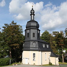
_(MGK22843).jpg/338px-Jubilate_Kirche_(Nordhalben)_(MGK22843).jpg)
Nordhalben
Steinbach am Wald
Stone meadows
Stockheim
_(MGK22843).jpg/338px-Jubilate_Kirche_(Nordhalben)_(MGK22843).jpg)


- 10 Tettau - Located at the foot of the Rennsteig and not far from the Thuringian border.
- 11 Teuschnitz - the arnica city near the Rennsteig.
- 12 Wallenfels - Located in the valley of the Wild Rodach with the Schlossberg chapel.


Tettau

Teuschnitz

Wallenfels


Other goals
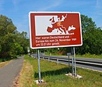
- Along today's border between Thuringia and Bavaria there are always remnants of the former GDR border installationsto see with tank lanes and border posts. Information boards are often used to point out the former inner-German border. The Green ribbon is a nature conservation project along the former inner-German border.
- The Ködeltalsperre also known as the Mauthaus drinking water reservoir Stone meadows.
- The Rennstein Park in Steinbach am Wald is located directly on the Rennsteig, only 14 kilometers of the famous Höhenweg run through Bavaria.
getting there
By plane
The closest international airport is the ![]() Nuremberg Airport (IATA: NUE)
Nuremberg Airport (IATA: NUE) ![]()
![]()
![]()

By train
The Frankenwaldbahn from Saalfeld to Lichtenfels drives through the area. The next ICE stops are in Saalfeld and Lichtenfels.
In the street
The runs along the edge of the western Franconian Forest Highway 73. There are also the federal highways B 173 and B 303.
mobility
Franconian Forest mobile is a regional bus and train network that makes it easy to do without your own car on weekends and public holidays. Buses and trains take you to many destinations, including bicycles Bad Steben, Coburg, Kulmbach, Kronach and the two MTB centers at Rennsteig and at Döbraberg. Frankenwald mobil runs from May to October. A network day ticket costs € 14 for a family, € 7 for an adult and € 2.50 for a child (as of 2020). For information on timetables and tariffs, call the service telephone number 49 9261-601516 (until Friday 12:00 noon).
Between Nordhalben and Stone meadows runs regularly between May and October Rodachtalbahn with the club's own historic rail bus.
Tourist Attractions

- 1 Lauenstein Castle, Burgstrasse 3, 96337 Ludwigsstadt. Tel.: 49 (0)9263 400, Fax: (0)9263 974422. The castle towers over the place Lauenstein and is a medieval castle near by Ludwigsstadt. Civil weddings can be held at the castle.Open: Apr.-Sept .: 9 a.m. to 6 p.m., Oct.-Mar .: 10 a.m. to 4 p.m., closed on Mondays.Price: € 4, reduced € 3.
- 2 Ködeltalsperre also called the Mauthaus drinking water reservoir. It was planned and built for the purpose of supplying drinking water. The solar-powered control boat should be of interest to technology fans. The Ködeltalsperre is a worthwhile destination due to its scenic location. The 12.5 km long paved and almost flat circular path is suitable for inline skaters, cyclists and hikers, a network of hiking trails and a nature trail are connected. However, water sports are prohibited. Information board with emergency telephone; Mobile sanitary facilities are located on the main dam, right next to the bike rental station. Cycle and skater bus from Kronach to Bad Steben via Steinwiesen and Mauthaus; (May to October, information: OVF Tel. 49 (0) 9561/76009); Bike rental Rattinger an der Talsperre, Tel. 49 (0) 9262/7617
- 3 Pond mill, at Steinwiesen. Tel.: 49 9261 94633. The only fully functional cutting mill in the Franconian Forest is looked after by the Rodachtal Mill Association and can be viewed.Open: From May 1st to the end of October on Sundays from 2pm to 5pm.

.jpg/350px-Ködeltalsperre_(MGK12717).jpg)

activities
- The Franconian Forest is Bavaria's first Quality region of Wanderable Germany. There are 32 Frankenwald-Steigla designated, hikes between 5 and 18 kilometers. The near-natural paths lead past sights and refreshment stops and are uniformly and seamlessly marked. Detailed information is available at wandern-im-frankenwald.de. In the whole of the Franconian Forest, a total of 4213 kilometers of hiking are looked after by 63 local groups of the Frankewald Association. The right hiking trail can be found for every taste and every level of fitness.
- Raft trips on the wild Rodach, a very wet and very rare pleasure. From late May to early September almost every Saturday from Wallenfels or Thursdays from Kronach-Neuses.
- Winter sports in Ludwigsstadt ski center - There are at Ludwigsstadt two drag lifts (altitude 470 - 700 m). Circular trails are also groomed.
shop
- Royal Tettau, Fabrikstr. 1, 96355 Tettau, Tel. 49 (0) 9269 9802-61 or 62, Monday-Friday 9:00 a.m.-5:00 p.m., Saturday 9:00 a.m.-1:00 p.m., porcelain factory outlet
kitchen
There are fewer inns, especially in the small villages. The opening times are also being reduced and there are more days of rest. If you are planning a stop, especially when hiking, you should call in advance whether there is open and if there is space. It is advisable to reserve a table in good time, especially on Sunday lunchtimes.
- 1 Mittelberger Radspitzeinkehr, Mittelberg 8, 96364 Marktrodach. Tel.: 49 (0)9223 686, Email: [email protected]. From Seibelsdorf, a district of Market roof, a paved forest path leads to the Radspitze. Here you will find a mountain hut with a rustic interior and beer garden. From up here you have a breathtaking view of the Franconian Forest.Open: Fridays from 3 p.m., Saturdays, Sundays and public holidays from 1 p.m.
- 2 Bauernhannla, Eichenbühl 82, 96352 Wilhelmsthal. Tel.: 49 (0)9260 9639399. Quaint inn with a great view, inside with a fireplace, outside with a huge beer garden.Open: Wednesday to Monday from 11.30 a.m. to midnight, Sundays and public holidays 9.30 a.m. to midnight, warm meals throughout, closed on Tuesdays.
In Kronach do they exist Blöchla, a lard pastry that is hollow on the inside and is made in the shape of a tube with a special iron. The blocks are simply sprinkled with powdered sugar and eaten mainly during the Kerwa season.
language
The dialect in the western Franconian Forest differs significantly from the other Franconian dialects in pronunciation and grammar.
Examples from the area:
- do - chamber , you can't do that - That is net made
- to annoy - geärcher
- lay - gelech
- sit down - hen law
- argue around - romgestried
- throw away - wechgeschüdd
- I do not believe that - I don't think so
climate

The climate in the Franconian Forest is harsh. In summer it is always a few degrees less than in the lowlands. In winter there is usually a lot of snow that remains until spring. If it is still raining in the Main Valley in autumn, it will already start to snow in the so-called Oberland. There have been years when the summer months were frost-free.
trips
In the north lies the Thuringian Forest, in the east of the Eastern Franconian Forest the Fichtel Mountains and the Hofer Land, in the south of the Obermain with the world heritage city Bamberg or the beer town Kulmbach as well as the festival city Bayreuth, in the west lies the duchy Coburg, the Hatred Mountains and the Grave field.
literature
cards
- Fritsch map publisher (Ed.): No. 51 Franconian Forest Nature Park, scale 1: 50,000. ISBN 978-3-86116-051-9 . Official hiking map of the Frankenwaldverein and the Naturpark Frankenwald e.V.
Web links
- Franconian Forest Tourism
- Bayern-Online
- Franconian Forest Nature Park
- Franconian Forest Association
- rennsteigregion-im-frankenwald.de - Tourist information of the Rennsteig region in the Franconian Forest
