 | ||
| Gefrees | ||
| federal state | Bavaria | |
|---|---|---|
| Residents | 4.332 (2019) | |
| height | 500 m | |
| no tourist info on Wikidata: | ||
| location | ||
| ||

The small town Gefrees lies on the western edge Fichtelgebirge and at the transition to Franconian Forest. To the north, the Münchberger plateau extends in Hofer Land and south that Main valley.
getting there
By plane
The nearest international airport is the Nuremberg Airport![]()
![]()
![]()
![]() (IATA: NUE).
(IATA: NUE).

In the street
Gefrees is on the six-lane, but still heavily traveled, motorway ![]() , which leads from Munich via Nuremberg to Berlin. The driver leaves the motorway at the exit
, which leads from Munich via Nuremberg to Berlin. The driver leaves the motorway at the exit ![]() 37 Gefrees and drives 3 km eastwards. The B 2 runs parallel to the motorway via Gefrees. Another road connects them
37 Gefrees and drives 3 km eastwards. The B 2 runs parallel to the motorway via Gefrees. Another road connects them ![]() ,
, ![]() 11 Thiersheim over Weißenstadt with Gefrees.
11 Thiersheim over Weißenstadt with Gefrees.
By train and bus
The connection to the rail network was completely abandoned. Even the Falls stop 5 km to the west on the railway line court–Lichtenfels is no longer served, so you can now click Marktschorgast, Stammbach or Münchberg has to evade. The next long-distance train stations are in Bayreuth, Hof and Marktredwitz.
Local public transport in the Nuremberg metropolitan region is operated by the Greater Nuremberg Transport Association VGN operated. It is possible to use different means of transport with one ticket, such as bus, train, S-Bahn or U-Bahn. The tickets can be purchased online or via an app.
mobility

The runs every Saturday evening Leisure bus the popular discos and dance halls in the district of Bayreuth.
Tourist Attractions
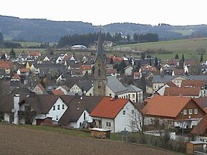
On the road to Bischofsgrün you have a beautiful view of the city. If you are traveling by car, it is best to park it on the left in the residential area and walk across the street to the park bench. Three high residential buildings on the right and the Evangelical Lutheran church in the center of the village dominate the townscape.
activities
Gefrees is for his Motorsport-Events known. Trial competitions are held regularly.
- City Hall
- Folk and meadow festival. From the Thursday before the second Sunday in July to the Monday after.
shop
- 1 REWE, Bayreuther Str. 4, 95482 Gefrees. Tel.: 49 (0)9254 9618040. Open: Mon - Sat 7 a.m. - 8 p.m.
kitchen
- 1 Because Michele, Roglerstrasse 5, 95482 Gefrees. Tel.: 49 9254 8146. Italian kitchen.Open: Tue to Sun 11: 00-14: 00 and 16: 30-22: 00.
- 2 Frozen kebab, Hauptstrasse 46, 95482 Gefrees. Tel.: 49 9254 9617274. Doner kebab and pizza.Open: Mon to Sat 11:30 a.m. - 8:00 p.m.
nightlife
accommodation
- 1 Green Tree, Main street 51. Tel.: 49(0)9254 337, Mobile: 49 (0)160 2063161, Fax: 49(0)9254 337. 20 beds.Price: Including breakfast: single room € 32-38, double room € 52-56, discount from three days.
- 2 Waldgasthof Schweinsbach, Schweinsbach 46, 95482 Gefrees. Tel.: 49 9254 246. 5 double rooms and 2 single rooms. Forest inn with its own slaughter.Price: Overnight stay with shower / toilet from € 22, shared shower from € 16, with breakfast.
- 3 Entenmühle Inn & Pension, Entenmühle 6, 95482 Gefrees. Tel.: 49 (0)9254 260. Feature: pension.
- 4 Gasthof Kornbachtal, Kornbach 12, 95482 Gefrees. Tel.: 49 (0)9254 8423.
 Guest rooms, inn with regional cuisine and beer garden.Feature: pension.Open: Mon, Thu, Fri 5:00 p.m. - 10:00 p.m., Sat, Sun 11:00 a.m. - 10:00 p.m., closed Tues, Wed.Price: single from € 43, double from € 70, main course from € 10.
health
- 1 Johannes Pharmacy, Hauptstrasse 42, 95482 Gefrees. Tel.: 49 (0)9254 91316, Fax: 49 (0)9254 91317, Email: [email protected]. Open: Mon, Tue Thu 8:30 a.m. - 1:00 p.m. 2:00 p.m. - 6:30 p.m., Wed Fri 8:30 a.m. - 1:00 p.m. 2:00 p.m. - 6:00 p.m., Sat 8:00 a.m. - 12:30 p.m.
trips
- Bischofsgrün (8 km southeast, via Gottmannsberg) - a holiday resort between Ochsenkopf and Schneeberg; not far outside a summer toboggan run.
- Bad Berneck (9 km southeast, B 2) - Kneipp spa since 1930 and Kneipp spa since 1950; Spa park with colonnades.
- Weißenstadt (11 km east) - Weißenstadt is located on the 50 hectare Weißenstädter See and on the upper reaches of the Eger, which rises southwest of the city.
- Wirsberg (11 km to the west, via Marktschorgast) - climatic health resort; a railway museum in the neighboring Neuenmarkt.
- Münchberg (12 km north, B 2) - the city on the Münchberger plateau is known as the location of the textile industry.
literature
- Weißenstadt -: Gefrees, Kirchenlamitz, Marktleuthen, Münchberg, Wunsiedel. Fritsch map publisher, 2015 (3rd edition), ISBN 978-3861161103 . Fritsch hiking maps 1: 35000, 6 €
Web links
- http://www.gefrees.de - Gefrees official website
- Homepage about the former Gefreeser local railway
