The High Fichtel Mountains is the part of the Fichtelgebirge with the two thousand meter peaks. The Fichtelgebirge Nature Park closes in the east Sechsämterland at.

places
- 1 Bischofsgrün


 in the Wikidata database") - a holiday resort between Ochsenkopf and Schneeberg; not far outside a summer toboggan run.
- a holiday resort between Ochsenkopf and Schneeberg; not far outside a summer toboggan run. - 2 Fichtelberg - east of the Ochsenkopfes with the Fichtelsee.
- 3 Flour chisel - with Bayreuth House, Klausenturm and game reserve
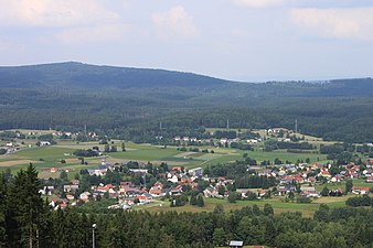
- 4 Warmensteinach - the climatic health resort at the foot of the Ochsenkopfes; Grassemann open air museum.


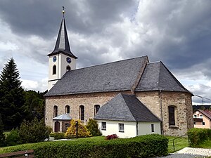
Bischofsgrün
Fichtelberg Annunciation
Flour chisel

Warmensteinach


Other goals
- The 1 Schneeberg (1,051 m above sea level) is the highest mountain in the Fichtelgebirge, with lichen and moss flora, the Backöfele observation tower (closed since 2014 due to dilapidation, a new tower is to be built); the road to the summit is closed to cars. A surveillance tower from the Cold War stands on the summit as a landmark that can be seen from afar. The listed building is not accessible.
- The 2 Ox head (1024 m above sea level) with observation tower (can be climbed with Excursion gastronomy), Chairlift), Summer toboggan run (1000 m long with 140 m difference in altitude) in Bischofsgrün and ski slopes is the most famous mountain in the Fichtel Mountains.

The transmission tower on the Ochsenkopf
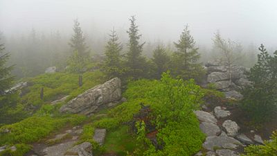
On the Ochsenkopf in fog

Backöfele, the highest vantage point in the Fichtel Mountains on the Schneeberg


- The 3 Nusshardt (972 m above sea level) with its granite and gneiss formations in the Schneeberg massif, with a sea of rocks and forms of weathering, is the most beautiful peak in the Fichtel Mountains. The summit area is protected as a NSG. Wide panorama over the heights of the high Fichtelgebirge. In winter, the summit is an attractive destination for a snowshoe hike. Interesting: There is a kind of "cave" with a sheltered resting place.

The nut hard, the most beautiful summit

View from Nußhart


- The Haberstein (972 m above sea level) a sea of boulders with granite towers lies on the western slope of the Schneeberg
- The Big kitchen (939 m above sea level) is a sea of boulders with granite towers on the western slope
- The Fichtelseemoor is a former raised bog near Fichtelsee near Neubau
- The Plate summit (885 m above sea level) is a granite peak with rock lichen flora
- The Königsheide with the Hohberg (863 m above sea level) is an upstream wooded ridge between Weidenberg, Goldkronach and Warmensteinach
- The 4 Source of the White Main at Bischofsgrün at the foot of the ox head.

- The 5 Egerquelle at Weißenstadt at the foot of the snow mountain.
- The 6 Fichtelnaabquelle, at Fichtelberg on the southeast slope of the Ochsenkopf.


The Fichtelnaab source

Egerquelle
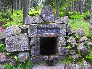
The Weißmain spring


background
The Fichtelgebirge represents a European watershed. Rivers arise on the slopes, which over the Elbe into the Baltic Sea, flow over the Danube into the Black Sea and over the Main and Rhine into the North Sea.
getting there
By train
There are train stations in Bayreuth (RE stop), Marktredwitz, Münchberg and Willow Hill, then continue with the bus. The Hohe Fichtelgebirge is free of railroad tracks.
- The EgroNet ticket. the Euregio Egrensis applies in the counties Greiz and Saale-Orla in Thuringia, in court, Kulmbach, Bayreuth, Neustadt an der Waldnaab, Pastures, Tirschenreuth and Wunsiedel in Upper Franconia, in Saxony in the Vogtland, Zwickau and the Western Ore Mountains and in Czech Republic in the region Karlovy Vary. The day pass for the second class costs 24 € (200 Kč in the Czech Republic) (plus 2 € in Germany if you buy at the counter) for the first person. For the 2nd to 5th person the additional charge is 8 € (100 Kč) each. You can make any number of trips with the participating transport companies on the day of validity until 3:00 a.m. the following day. In addition, you are allowed to take 3 children between 6 and 14 years and any number under 6 years with you. One bike per person is also free. The surnames and first names of all travelers must be entered in block letters on the ticket, identification must be carried.
In the street
The high Fichtelgebirge lies between the A 9 Nuremberg / Leipzig and the A 93 Hof / Regensburg. It also crosses the federal highway B 303 from Bad Berneck via Marktredwitz Cheb (Eger).
Park
There are parking ticket machines at the cross-country skiing and hiking car parks around the Ochsenkopf. For € 2 (2019) you can park for 24 hours, also in various paid parking spaces. There is also a season ticket for € 20 and an annual ticket for € 30, which you can buy directly at the cable cars at Ochsenkopf Tel. 49 9276 644. The parking fees are used for clearing and scattering services, the preparation of cross-country ski trails and winter hiking trails, etc. Complaints and Questions to fairparken GmbH, Tel. 49 211 - 96082630 or e-mail: [email protected]
mobility
From May 1st to October 3rd, the Fichtel Mountains were in the Cycle buses to disposal. They run on Saturdays, Sundays and public holidays.
Tourist Attractions
- 7 Grassemann open air museum, Grassemann No. 3, 95485 Warmensteinach. Tel.: 49 9277 6105. Open: May to October, Wednesday - Sunday, 11 a.m. - 4 p.m.; January to April, Sunday 2:00 p.m. - 4:00 p.m.Price: children free, adults: € 2.50.
- 8 Gleißinger Fels silver iron mine, BT4, 95686 Fichtelberg.
 The oldest Mine Northern Bavaria, in operation for 500 years.Open: 13.02. - 03.03. and 27.03. - 04.11.2017 Guided tours daily from 11 a.m. to 4 p.m. on the hour.Price: Adults € 6, 5-15 years € 5.
- Luisenburg at Wunsiedel with the Open air festival and the Rock maze
activities

winter
The Ski area on the Ochsenkopf is served by two chairlifts in 1 Bischofsgrün and in 2 Fleckl served. There are two easy runs with a total length of approx. 3.5 km. The longest slope is 1850 m long. Snow cannons are available. Further information: www.seilbahn-ochsenkopf.de
Also for the popular sport Nordic walking An extensive network of paths was created in the Kornbach-Wülfersreuth-Bischofsgrün area. A classification into “blue tours” (easy), “red tours” (medium) and “black tours” (difficult) is made. The following routes can be found in the Bischofsgrün-Wülfersreuth area:
- 1 Bischofsgrün "Beautiful view": 5.2 km; 117 m difference in altitude
- 2 Bischofsgrün quarry: 4.2 km; 55 m difference in altitude
- 3 Bischofsgrün Göhren: 5.9 km; 165 m difference in altitude
- 4 Bischofsgrün Ochsenkopf: 13.0 km; 425 m difference in altitude
- 5 Wülfersreuth Margraves: 6.3 km; 85 m difference in altitude
- 6 Wülfersreuth Panorama: 7.5 km; 139 m difference in altitude
For the Gefrees-Kornbach area:
- 1 Gefrees / Kornbach Rödelberg: 6.3 km; 116 m height difference
- 2 Gefrees / Kornbach Hirtengarten: 8.3 km; 192 m difference in altitude
- 3 Gefrees / Kornbach Hohe Haide: 14.5 km; 280 m difference in altitude
Winter hiking trails are marked with yellow signs. Some of them run right next to cross-country trails, neither the groomed nor the groomed trails, everyone has their own area! Do not leave the signposted hiking trails. Frightened wild animals are forced to use unnecessary energy when fleeing, which can mean death for animals at this time of the year.
summer
- Climbing forestOx head Outdoorparc, directly at the valley station / north of the cable car at Ochsenkopf, Fröbershammer 27, 95493 Bischofsgrün, Tel 49 (0) 9276-926958 the climbing forest is open Wednesday to Sunday 11 a.m. to 5 p.m., during the summer holidays daily, winter and night on request , a total of 6 courses up to 18 m high and a 12 m high climbing wall.
- Germany's first Zipline park opened in 2011. After a briefing on 12 steep rope routes, called ziplines, you can safely descend the Ochsenkopf on a pulley at high speed. Tree platforms were set up at a height of over 20 meters in order to switch from one rope route to the next, the longest being 460 meters long. Parking in the parking lots at the Ochsenkopf Süd valley station in Fleckl / Warmensteinach. The start and information point is at the Ochsenkopfhaus / Bullheadhouse restaurant, 50 meters from the valley station.
kitchen

Gastronomic destinations outside of the locations listed above:
- Franconia's highest located inn on the Ochsenkopf that 1 Asenturm summit restaurant, Ox head (95485 Warmensteinach). Tel.: 49 (0)9276 252, Email: [email protected]. In case of bad weather and storms, it is essential to call in advance, as the restaurant remains closed if there is little visitor expectation.Open: The opening times are from 9 a.m. to 6 p.m., Monday is closed, but the kiosk is open.
- 2 Lake house, Lake house 1 (95709 Tröstau). Tel.: 49 9272 222, Fax: (0)9254 7284, Email: [email protected]. The FGV accommodation facility, which is managed all year round, is located on a ridge between Nusshardt 972 m and Platte 884 m in the Schneeberg massif. Schneeberg 1051 m on the western slope of the lake hill 953 m. The intersection of the Höhen- u. Mittelweg and since March 2007 on the Franconian mountain path. There are places to stay.Open: Tue to Sat 10 a.m. to Hüttenruhe, Sun 10 a.m. - 6 p.m., closed on Mondays.

- This is between the two highest peaks in the valley, directly on the B 303 3 Waldrasthaus Karches, Karches 2 (95493 Bischofsgrün). Tel.: 49 (0)9276 218, Fax: (0)9276 926827, Email: [email protected]. It is a good starting point for hikes on the Ochsenkopf or Schneeberg, to the source of the White Main or down the young White Main.Open: Open from May to October daily 9 a.m. to 8 p.m. and from November to May 10.30 a.m. to 7 p.m., closed on Thursdays.
- The restaurant is located directly on the B 303, west of Tröstau 4 Silver house, On the B 303 (95709 Tröstau, district Silberhaus 1). Tel.: 49 (0)9236 1535, Fax: (0)9236 969935, Email: [email protected]. It is a good starting point for hikes.Open: Closed on Mondays, from Tuesday to Sunday from 11 a.m.Price: Overnight stays in a double room from € 18 per person, with breakfast.
accommodation
In the rest areas described above Lake house and Karches can also be stayed overnight, but you should reserve in good time.
security
In regularly published police statistics, Upper Franconia is shown as the administrative district in Bavaria with the fewest criminal offenses per inhabitant. In terms of security, Bavaria is one of the leaders in the national average.
Parts of the Fichtelgebirge are in the area close to the Czech border, where the so-called veil manhunt takes place in the hinterland after the border controls are no longer applicable.
In the mountains themselves, she cares Mountain Rescue for safety for hikers and skiers. BRK Bergwacht, Tel. 49 9276 352, Mountain Rescue Section Fichtelgebirge, Tel. 49 9276 91090
climate
The high position of the Fichtelgebirge brings a rough mountain climate with it; in the higher parts the first ripening begins at the end of August, and snow often falls as early as the end of September. It rarely melts away from the fields before the beginning of May, and snowdrifts are likely to remain in the forest and between the rocky cliffs until the end of June. Night frosts occasionally set in around Midsummer; only August and September bring beautiful, warm days. With the abundance of forests and swamps in the mountains, fog often rises; if they envelop the mountain tops, then they proclaim rain.
literature

Hiking maps:
- Fichtelgebirge Nature Park and Steinwald Nature Park. Hiking map. With tourist. Notes, colored path markings and parking spaces for hikers. Official hiking map. d. Fichtelgebirgsverein u. D. Fichtelgebirge Nature Park 1: 50,000 16th edition. Fritsch Landkarten-Verlag Hof (Fritsch Karten: No. 52) undated, ISBN 3-86116-052-8
- Kompass hiking and biking map 191 "Fichtelgebirge", Scale 1: 50000, 6.95 euros, ISBN 978-3-85491-196-8 see also www.kompass.at
Web links
- Ochsenkopf adventure region in the Fichtel Mountains
- Fichtelgebirge Nature Park
- www.bayern-fichtelgebirge.de - Website of the Fichtelgebirgsverein e.V. Wunsiedel about the Fichtelgebirge
Webcams
- Webcams of the Ochsenkopf cable car - 3 cameras: valley stations and a camera on the mountain top