The Rotmain cycle path is part of the Main cycle path and starts in Cussen in the Franconian Switzerland. It starts at the source of the Red Main and then descends for about 14 km Bayreuth. From there it leads over to the former railway line Kasendorf, Thurnau and Neudrossenfeld until Weißmain cycle path on the western outskirts of Kulmbach. The shorter valley variant is in the article Main cycle path described.

Route profile

Length: approx. 50 km on the valley path; approx. 62 km on the railway cycle path, of which approx. 30 km on the former railway line.
Signposting: Well
Slopes: largely flat with two moderate inclines
Path condition: largely paved
Traffic load: low
Suitable bike: each
The Rotmain cycle path is part of the Main cycle path and starts in Cussen in the Franconian Switzerland. It starts at the source of the Red Main and then descends for about 14 km Bayreuth. From there it leads over to the former railway line Kasendorf, Thurnau and Neudrossenfeld until Weißmain cycle path on the western outskirts of Kulmbach. The shorter valley variant is in the article Main cycle path described.
Route profile
Length: approx. 50 km on the valley path; approx. 62 km on the railway cycle path, of which approx. 30 km on the former railway line.
Signposting: Well
Slopes: largely flat with two moderate inclines
Path condition: largely paved
Traffic load: low
Suitable bike: each
Family suitability: Yes
Inline suitability partially
background
The cycle path was largely built on the old railway line of the Thurnauer Bockerla, so that the gradients are moderate.
preparation
The usual preparation for a bike tour is sufficient; no special measures are necessary for this route.
If the preparation is not enough, the following bicycle workshops are on the route:
- 1 Schröck two-wheel service, Erlanger Str. 33, 95444 Bayreuth. Tel.: 49 921 64877.
- 2 RadBox - the bicycle self-help workshop, Universitätsstrasse 30, 95447 Bayreuth.
- 3 Hensel & Koller wheel house, Nürnberger Str. 48, 95448 Bayreuth. Tel.: 49 921 721489.
- 4 LandRad, Oberes Dorf 22, 95349 Thurnau. Tel.: 49 9228 97016.
- 5 Eldorado, Bayreuther Str. 40, 95326 Kulmbach. Tel.: 49 9221 64779.
getting there

Public transportation
Details on how to get there are on the pages of Cussen, Bayreuth and Kulmbach.
By train
Of Nuremberg The regional train runs from here every hour Hersbruck, Neuhaus an der Pegnitz and Pegnitz to Creußen and Bayreuth.
In the street
Highway ![]() Berlin - Munich, Bayreuth exits
Berlin - Munich, Bayreuth exits
Highway ![]() Kulmbach - Schweinfurt, exit Kulmbach / Neudrossenfeld or exit Thurnau
Kulmbach - Schweinfurt, exit Kulmbach / Neudrossenfeld or exit Thurnau
By bicycle
To start in Bayreuth, go to Bayreuth-Chemnitz cycle path; if the start is to be in Kulmbach, then via the Main cycle path.
Route description with sights
Creußen - Rotmainquelle - Bayreuth 24 km

From 1 Train station in Cussen it's only 9 km up to the 1 Source of the Red Main, from there further to 1 Hague, 2 Unterschreez, 3 Destuben to Bayreuth. The town Bayreuth can be traversed in different ways. There is an overview of the cycle paths in the city on the Cycle network map
There is also a cycle path from Creußen directly to Bayreuth. He always stays near the federal highway 2 and is as Pegnitz cycle path signposted. The more scenic route is over the Rotmainquelle.
- 1 Brewery & Landgasthof Kurzdörfer, Brauhausgasse 5, 95473 Creussen / Lindenhardt. Tel.: 49 (0) 9246 221. Franconian cuisine in the newly built log cabin. The inn is only 3 km from the source. Dogs are not allowed.Open: daily 11 a.m. - 11 p.m., closed on Mondays, kitchen 11 a.m. - 2 p.m. and 3:30 p.m. - 8 p.m.Price: Schnitzel with potato salad € 7.80, half a liter of beer € 2.20.
Bayreuth - Neudrossenfeld 12 km

If you have the 2 Bayreuth Leaving the train station, take the sidewalk down the hill to the left 4 AnnecySquare with the big intersection. There you cross Bahnhofstrasse to the right and you are on the Rotmain cycle path. From here always follow the signs to Kulmbach. The Red Main that you want to follow is the deplorable trickle in the concrete bed. Not for nothing do the Bayreuthers complain about the “unbearable shallowness of the Main”.
The path leads along streets along the river to the Rotmain-Center, the largest shopping center in Bayreuth, where you can get a snack, but there is no supermarket. Behind the 5 -Parking house you come to a beautiful, shady avenue that leads out of town. After crossing under the Bayreuth Nordring you have to decide whether you want to drive on dirt roads through the Main meadows or on tarred paths past the sewage treatment plant to Heinersreuth.
In 6 Heinersreuth remains the cycle path in the Main meadows and peripheral areas. There are various places to stop for a break in the village. After the place the path runs next to the federal highway 85, at 7 Unterwaiz goes a few meters uphill and then you have to cross the main road at the traffic lights. A few more meters in altitude to the summit, then you roll on 8 Altenplos into it. Cross the main road again and drive past the inn on the left. On the right is the castle of Altenplos (privately owned) and you cross the river. The small road leads over slightly hilly 9 Threschenau to Neudrossenfeld.
- 1 Bergmühle Hotel-Restaurant, Bergmühlgasse 2, 95512 Neudrossenfeld. Tel.: 49 (0)9203 6644. Franconian and international cuisine, coffee and cake, snacks. Historic mill below the castle, with a view of the Rotmaintal water and bird sanctuary.Open: Tuesday to Sunday from 11.30 am to 9.30 pm, closed on Mondays in the restaurant, winter November to March open Thursday to Sunday, hotel non-stop.Price: single from € 58, double from € 75.
In Neudrossenfeld the path leads past the listed mountain mill, which has been converted into a hotel and restaurant. Further in the valley over the 2 old stone bridge after Altdrossenfeld. However, you should accept the few meters in altitude and take the 3 See the church and the castle. The terrace garden at the castle offers a wonderful view over the valley of the Red Main and in the castle itself one is entertained in the most exquisite way. After the stone bridge you drive on 2 Brauereigasthof Schnupp with overnight accommodation and turn right about 100 meters further from the street.
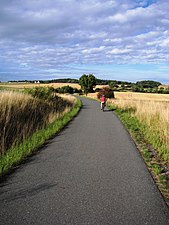
A few meters uphill, then it turns 10 Cycle path to the right (see picture) and it goes there again. At the wayside there are works of art at regular intervals that loosen up the journey. You drive off comfortably 11 Unterobsang (the name comes from absengen) until there is a concrete plant on the left. On the left on the railway line, you continue to Thurnau, as described in the next chapter.
Now you have to decide 12 If you take the abbreviation and stay in the Rotmaintal, you drive on country roads to the Main Cycle Path or to Kulmbach, or you continue to follow the railway line and come across the worthwhile places Thurnau and Kasendorf to the same goal. The 10 km longer mountain route is the more recommended option.
Neudrossenfeld - Melkendorf (valley section) 15 km
The valley path leads under the motorway to 4 Langenstadt with church, old stone bridge and dancing linden tree next to the inn. At the end of the village the street crosses the Red Main and continues to Unterlettenrangen, further over 13 Threshing, 14 Lanzenreuth and Windischenhaig to 15 Katschenreuth, a district of Kulmbach at 16 Mainz confluence.
- 3 Gasthof Hereth "To the green wreath", Windischenhaig 8, 95326 Kulmbach. Tel.: 49 9221 7 45 81. Room with shower and toilet. Inn with Franconian cuisine and its own house slaughter.Price: Overnight stay with breakfast, single room from € 30, double room from € 60.

Mountain or valley path

Branch between Neudrossenfeld and Unterobsang

Art on the bike path


Neudrossenfeld - Kasendorf (mountain route) 15 km
We choose that 17 Railway line. The path goes up the mountain on a gentle slope, the second half of the slope in the forest is only gravel. After you hit the paved bike path again, you continue on the road 18 right down. Halfway downhill, the cycle path turns right and goes around Limmersdorf. If you take the exit to the main road, then left and right again after 100 m, you come to 5 Church and to the Tanzlinde. On the way back, follow the main road and come back to the bike path at the end of the village.
Now it works 19 down into the valley past the tennis court to the Schorrmühle. The bike path goes up the small mountain on the left. However, it is recommended after 6 right over the small bridge along the lake into the center of Thurnau to drive. The 7 medieval ensemble with pottery museum, church and castle is really worth seeing. There are also opportunities to stop off or stay overnight. From the town center, follow the signs to Kasendorf and meet 20 back on the bike path.
If you stay on the bike path at the Schorrmühle, you have to overcome the small incline, then turn right on the main road down into the right of way and then right again up to the old people's home. At the senior village 21 past the path leads slightly up over the 22 Golf course. Some sections of the cycle path are protected on one side or completely with grids against flying bicycle routelfballs. Once at the top you can enjoy the view or watch the golfers tee off.
A shady forest run goes down to the sports field. After the bridge 23 there is the possibility to turn left and past the church into the 8 Center of Kasendorf to drive. There are places to stop for refreshments and overnight stays. The bike path crosses the main road and leads to a grove where there is an educational trail and 9 Stone Age barrows are there.

Thurnau should not be bypassed

Protecting cyclists from golf balls
Bike path near Heubsch

The center of Upper Franconia


Kasendorf - Melkendorf 10 km
The way goes on, lets Lovely lie on the left and cross the street again. At this point, caution is advised, the cars can only be seen shortly before the crossing. If you turn left here and drive a few 100 m up the road, you will see a spiral sculpture on the right side in the area, here it was 10 Center of Upper Franconia calculated. It goes back on the road to the bike path.
After a short time you reach 24 Crooked fore. If you cross the street and look to the left, you will see a blackboard on weekends in summer, the sign that the vine arbor is open and invites you to take a rest. A long, shady forest run follows. After leaving the forest, one meets the road after Pross, 25 Be careful when crossing the road. At the end of the downhill section you reach 26 Katschenreuth.
At the end of Katschenreuth know a sign on the Mainz confluence down. The Red Main and the White Main unite about 500 m from the cycle path. A bridge has been built there, and the bike path will probably change. From the confluence you can over a bridge and a footpath (push) out to the 11 Steinenhausen Castle. The castle is used by an authority and unfortunately cannot be visited. From the castle you drive the street direction 12 Melkendorf and hits the bike path again. If you cross the bridge, the cycle path continues to the Kieswäsch recreation area with the 27 Possibility to swim. With this abbreviation one bypasses Kulmbach and meets with Mainleus on the Main cycle path.
If you leave the Mainz confluence on the left, continue on the cycle path over the Red Main, up the small, steep mountain, left to Steinenhausen Castle. Be careful in the mountain curve, please watch out for oncoming traffic. Past the Melkendorfer sports field, on to the church. Shortly after the church, the cycle path turns left and after about one kilometer meets the Main cycle path to continue to Mainz. However, you should visit the Kulmbach city center and the Plassenburg not to be missed.
In the center of Kulmbach next to the Dr.-Stammberger-Halle (town hall) 28 is a Bicycle garage with 12 individual boxes for bicycles, two boxes are equipped with a battery charging station for e-bikes, there is also a changing room to change your sweaty cycling clothes and to explore the city in a relaxed way. The facility is open from April to October from 8:00 am to 10:00 pm, the cost is € 1 per bike. The tourist information is on the opposite side of the large car park and there is a public toilet at the entrance to the underground car park.

The new bridge at the Mainz confluence

Steinenhausen Castle

Market square in Kulmbach with a view of Plassenburg
.JPG/338px-Kulmbach_Fahrradgarage_(3).JPG)
The bicycle garage


.JPG/338px-Kulmbach_Fahrradgarage_(3).JPG)
security
The cycle path is largely free of traffic, special attention is required when crossing roads and bends should be driven on the right-hand side to avoid collisions. It should definitely be ridden with a bicycle helmet.
trips

On the Weißmain cycle path to the source of the White Main or via the Main cycle path to the mouth up Mainz.
The Bayreuth-Chemnitz cycle route leads from Bayreuth over court, Plauen, Zwickau to Chemnitz.
References to literature and maps
- A new 1: 50,000 cycle map is available for the district of Kulmbach. The map is also available as a digital map with a GPS coordinate grid, POI and tracks. The card can be obtained from District of Kulmbach.
- Fritsch hiking maps 1: 50,000, No. 65 - Franconian Switzerland Nature Park, North sheet