
The Steigerwald is in the middle Francsthat politically too Bavaria belongs. The picturesque Mittelgebirge can be found between the cities Wurzburg, Schweinfurt as Bamberg and Nuremberg. Anyone visiting the Steigerwald will find Franconian wine and forest.
Regions
- The Steigerwald foreland is located in south-eastern Lower Franconia and ranges from Main triangle to the Steigerwald. The region is predominantly agricultural, and viticulture plays a significant role.
- The nine parishes in Schwarzenberg country: Baudenbach, Langenfeld, Bibart market, Nordheim market, Taschendorf market, Münchsteinach, Oberscheinfeld, Scheinfeld and Sugenheim.
places

- 1 Castell


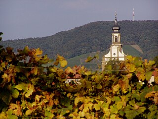
 in the Wikidata database") - Renowned wine town with a baroque castle.
- Renowned wine town with a baroque castle.
- 2 Ebrach - was the first Cistercian monastery on the right bank of the Rhine in Germany.

- 3 Eltmann - Numerous historical buildings and the pilgrimage church "Mariä Visitation" built by Balthasar Neumann in the OT Limbach.

- 4 Handthal - with the location "Handthaler Stollberg" the highest wine-growing region in Franconia and the information and experience center Sustainability Forest.

Castell Castle

Ebrach Monastery

Eltmann

Handthal


- 5 Zell am Ebersberg - Small wine-growing village in the Haßberge district, which is often referred to as the northern gate of the Steigerwald.
- 6 Iphofen - Renowned wine town with well-preserved city fortifications;

- 7 Oberschwarzach - lies on the western edge of the Steigerwald with the Handthal

- 8 Pommersfelden - with Weißenstein Castle, a major baroque work and one of the largest castle complexes in Germany.


Zell am Ebersberg

Iphofen

Oberschwarzach

Weißenstein Castle Pommersfelden


- 9 Rödelsee - Wine-growing location on the Schwanberg;

- 10 Scheinfeld -

- 11 Key field - with the ensemble of restored town houses around the market square

- 12 Stegaurach - lies in the valley of the Aurach


Rödelsee

Schwarzenberg Scheinfeld Castle

Key field
.jpg/232px-Stegaurach_-_panoramio_(2).jpg)
Stegaurach


.jpg/232px-Stegaurach_-_panoramio_(2).jpg)
Other goals
- The 1 Steigerwald treetop path, Radstein 2, 96157 Ebrach, Germany. is a 1152 m long, continuously barrier-free path, at an average height of 26 m above ground, with an observation tower made mainly of wood.

background

Geologically the Steigerwald is regarded as a type landscape for the Keuper soil layer. This is of very practical importance for him wine growing in the Steigerwald: The heat-storing keuper (marl and gypsum) around the wine towns of Iphofen, Castell and Wiesenbronn is considered to be the typical soil component in the character of the wine taste for Steigerwald wine.
The region is eponymous for the Steigerwald formation, a geological term for a special layer of Keuper soil that occurs throughout southern Germany and for which the Steigerwald is typical (wikipedia: Steigerwald Formation). The Steigerwald finds its geological continuation in the Keuper ridge of the Hatred Mountains, from which it is separated on the north side by the Main.
The Steigerwald is the second largest deciduous forest area in Bavaria after the Spessart and consists of 70% beeches. There are currently serious efforts to designate the northern Steigerwald as a national park, it would then be the 15th in Germany with an area of around 10,000 - 11,000 hectares. The reason given is the ecological diversity of the no longer managed beech forests and their typical biodiversity for the bird world (woodpecker species such as the middle woodpecker, gray woodpecker, black and collar flycatcher and barnacle and barnacle owl), mammals (15 bat species) and the biodiversity of insects and mushrooms.
Steigerwald Nature Park
The Steigerwald Nature Park has existed since 1988 and covers an area of 1,280 km² according to shares with 49% in Middle Franconia.34% in Lower Franconia and 17% in Upper Franconia distributed.
From 2012, by resolution of the Bavarian cabinet in Handthal the "Center-Sustainability-Forest" as "an attractive information and experience center with exciting offers that should convey the value and necessity of sustainable forestry".
language
German with a Franconian touch.
getting there
By plane
The closest international airport is the ![]() Nuremberg Airport (IATA: NUE)
Nuremberg Airport (IATA: NUE) ![]()
![]()
![]()

In the street
The Steigerwald ends in the north at the Maintalautobahn ![]() , in the middle he is off the freeway
, in the middle he is off the freeway ![]() and the federal highways
and the federal highways ![]() ,
, ![]() and
and ![]() cut through and to the east by the federal highway
cut through and to the east by the federal highway ![]() limited.
limited.
mobility
The federal highways 8 and 22 lead in an east-west direction through the Steigerwald.
Tourist Attractions
Churches
- Ebrach with a former Cistercian monastery and an outstandingly preserved early Gothic-Classicist abbey church;
Castles, chateaux and palaces
- The Weissenstein Castle in Pommersfelden, one of the main works of the German baroque;
mountains
| Surname | Height in meters (m) | place | info |
|---|---|---|---|
| Scheinberg | 498.5 m | Weigenheim | |
| High Landsberg | 498.0 m | Weigenheim | Hohenlandsberg castle ruins |
| Zabelstein | 489.0 m | Michelau in the Steigerwald OT Hundelshausen | Zabelstein viewpoint |
| Great Knetzberg | 487.5 m | Knetzgau | |
| Iffigheimer Berg | 482.0 m | Willanzheim | Iffigheimer Berg observation tower |
| Katzenberg | 480.0 m | Oberschwarzach OT Schönaich | |
| Schlossberg | 477.0 m | Altenschönbach | |
| Deer hill | 477.0 m | Oberschwarzach OT Schönaich | |
| Stollberg | 476.0 m | Handthal | Stollburg castle ruins |
| Schwanberg (Steigerwald) | 474.0 m | Rödelsee OT Schwanberg | Schwanberg Castle (Franconia) |
| Friedrichsberg (Abtswind) | 473.0 m | Abtswind | Friedrichsberg hunting lodge |
| Factory Schleichacher Berg | 470.0 m | Rauhenebrach | |
| Kreuzberg | 470.0 m | Ebrach OT yard | |
| Bocksberg | 468.0 m | Michelau in the Steigerwald OT Hundelshausen | |
| Hofer Berg | 466.0 m | Ebrach OT yard | |
| Herrschaftsberg | 463.0 m | Weigenheim | Frankenberg Castle |
activities
- The Steigerwald Panorama Trail has a length of 160 kilometers and leads from Bamberg to Bad Windsheim. It leads past many vantage points and panoramic views, past castles and ruins.
- The Methuselee bike is a short circular hiking trail at Ebrach to several particularly old character trees of the Steigerwald.
- Regular Wine festivals: see also the overview in the article Main Franconia;
- The Steigerwald Motodrom in Gerolzhofen is a Outdoor go-kart track with rental kart.
kitchen
To the northeast, in the area of Bamberg beer is drunk, wine is drunk to the west and south. Especially the typical Franconian, hearty cuisine is very common, which is widely known for its often very low prices.
Typical dishes for the area include:
- Plucked - spicy cheese cream (called Obatzter in the Bavarian region)
- Franconian sausages (mostly "coarse" sausages)
- Schäuferla - hearty meat dish made from the flat pork shoulder
- Knöchla - cooked or grilled knuckle
- Various types of homemade sausage (e.g. white pressack, red laid, liver sausage)
- Boiler meat

New wine with plucked cheese

Salzknöchla with sauerkraut and bread

- Cabbage sausage consists of pork to which about a third sauerkraut or boiled white cabbage are added. They are eaten fresh or smoked. In the herb season from October to March, you can get them in butchers and inns.
nightlife
security
Practical advice
Steigerwald Tourist Association, Hauptstrasse 1, 91443 Scheinfeld, Tel. 09162-12424, Fax -12433. Opening times: Mon - Thurs 8 a.m. - 12 p.m. and 2 p.m. - 4 p.m., Fri 8 a.m. - 12 p.m.
climate
trips
This is in the west of the Steigerwald Main triangle with his viticulture, in the south you can find that Aischgrund with his carp, there are those in the north Hatred Mountains with castles and half-timbered houses and in the east the Franconian Switzerland with their breweries.
13 Bamberg![]()
![]()
![]()
![]() is always worth a trip. It is located on a northeastern branch of the Steigerwald; the historic city center is a UNESCO World Heritage Site.
is always worth a trip. It is located on a northeastern branch of the Steigerwald; the historic city center is a UNESCO World Heritage Site.
_10.JPG/350px-Altes_Rathaus_(Bamberg)_10.JPG)
literature
- : The Steigerwald and its foreland: walks into the history of the earth; Vol.13. Dr. Friedrich Arrow, 2002, ISBN 978-3899370096 ; 160 pages. approx. € 22
Web links
- steigerwald.org with tips and information
- Bavarian State Forests: www.baysf.de (Information and guided tours)

