
The Odenwald is a low mountain range in the southwest of Germany. Politically, large parts of the Odenwald belong to it Hesse. Parts of the low mountain range are also in Bavaria and Baden-Wuerttemberg.
Regions

- Mountain road - wine-growing area
- Front Odenwald - "Granit-Odenwald"
- Buntsandstein-Odenwald - also "Hinterer Odenwald": wide forests and thin settlements make this part of the mountain so attractive.
- Badischer Odenwald - to Baden-Wuerttemberg belonging parts of the Odenwald to the right of the Neckar as well as the Kleine Odenwald.
- Little Odenwald - mountainous region south of the Neckar; forms the transition to Kraichgau
The 3500 km² Geo-Naturpark Bergstrasse-Odenwald includes (from west to east) the Bergstrasse, the Crystalline Odenwald and the Buntsandstein-Odenwald as well as the Main Valley. Different than the others Nature parks in Germany the Geopark puts its focus on the geological features, including pits and caves, rocky seas and rock formations, sands and dunes, different cultivation areas (e.g. fruit) as well as educational trails on settlements, mining, mills, legends, dragons and other topics. Hiking and cycling are available as activities, although there are also several barrier-free options. Youth tent sites and barbecue huts are intended to bring the "young people" closer to nature, the "Geopark-from-Hof" program combines holidays on the farm with the possibilities of the Geopark and is especially intended for families.
Further information at:
Geo-Naturpark Bergstrasse-Odenwald (Office), 64653 Lorsch, Nibelungenstrasse 41. Tel.: (0)6251 707990, Fax: (0)6251 7079915, Email: [email protected].

places


Places and cities of major tourist importance:
- 1 Amorbach


 in the Wikidata database") , Baroque town in the Bavarian Odenwald
, Baroque town in the Bavarian Odenwald - 2 Bad King
- 3 Beerfelden
- 4 Beeches (Odenwald)
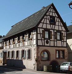
- 5 Bensheim- Worth seeing are, among others, the old town, the Castle ruins of Auerbachund Castle Princely camp
- 6 Eberbach - historical old city
- 7 Erbach (Odenwald) - Residence town in the Mümlingtal
- 8 Fuerth (Odenwald)
- 9 Grasellenbach - Higher-lying holiday community with a stimulating climate
- 10 Heppenheim - Half-timbered town on Bergstrasse
- 11 Hesseck - very small community with a lot of forest in the rear Odenwald. Anyone looking for peace and quiet largely off the beaten track has come to the right place.
- 12 Hirschhorn (Neckar) - historical old town with castle
- 13 Highest in the Odenwald
- 14 Lindenfels - also called "Pearl of the Odenwald"; pretty hillside location with a view of the Weschnitz valley, worth seeing old town with castle ruins, dragon museum
- 15 Mosbach - District town of Baden-Württemberg Neckar-Odenwald district on the border with Building land
- 16 Michelstadt - Center of the rear Odenwald with half-timbered old town
- 17 Miltenberg - Half-timbered pearl on the Main
- 18 Mossautal - Rural holiday community in the central Odenwald
- 19 Neckargemünd - Located in the small Odenwald, the Dilsberg mountain fortress invites you to visit.
- 20 Neckarsteinach - City of four castles on the Neckar
- 21 Reichelsheim (Odenwald) - place at the German half-timbered street
- 22 Schönau (Odenwald) - Located in the southern Odenwald on the Steinach
- 23 Wald-Michelbach
- 24 Walldürn - Place of pilgrimage
- 25 Zwingenberg (Baden) - The castle and the Wolfsschlucht are worth seeing
- 26 Zwingenberg (Bergstrasse) - small historical town at the foot of the Melibokus


On the edge of the Odenwald:
- 27 Darmstadt - The castle and Mathildenhöhe are worth a visit
- 28 Groß-Umstadt in the north - old town
- 29 Heidelberg - known and loved
- 30 Weinheim - a popular city on Bergstrasse


Other goals
background

Geographically, the Odenwald lies between the Upper Rhine Plain, the Neckar and the Main. The northeastern neighboring mountain range is the Spessart. To the east, the hill country closes Building land at.
language
Ourewellerrisch, the Odenwald dialect, is not always immediately understood by strangers. If you come from the metropolitan areas, which are characterized by High German, you can learn interesting expressions in the Odenwald:
- Babbel net! = Don't lie to me!
- Benzniggl = St. Nicholas
- Bobbelsche = infant, baby
- Gähleriewe ("yellow turnip") = carrot
- Gosch = mouth
- Hey mer uff! = Oh, stop it!
- Laddeguschtel = "The crucified one"
- Schimmeldewoog = Schönmattenwag (a village that to Wald-Michelbach belongs)
getting there
mobility
Road traffic
The mountains are well developed with roads that are popular with motorcycle tourists in the warm half of the year.
Public transport
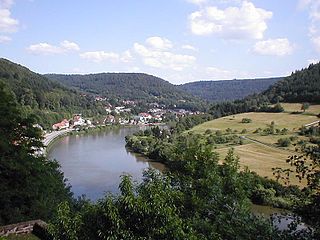
bus and train are unfortunately poorly developed in the Odenwald. Exceptions to this are the Weschnitz Valley and Odenwald Railway, with which there is a direct connection to Frankfurt am Main has, as well as the Neckar Valley with the S-Bahn from Mannheim above Heidelberg.
- NaTourBuss With free bike transport, the NaTourBus commutes every two hours on weekends and Hessian public holidays between Eberbach am Neckar, Beerfelden, Erbach, Michelstadt, Amorbach and Miltenberg am Main.
For trips away from larger cities, it is advantageous to have a car available.
By bicycle
The Bike paths require some conditions. The Odenwaldbahn takes bicycles free of charge outside of rush hour traffic in the Hessian RMV-Verbund tariff area. The Hessian long-distance cycle route R4 runs from north to south to Neckar valley cycle path, the Hess goes from the Rhine Valley. Long-distance cycle route R9 high with connection to the Bavarian Main cycle path.
The Hess runs on the western edge of the Odenwald. Long-distance cycle route R8 and the Rhine Valley Path.
In general, however, it can be stated that, apart from the few main national routes, there is unfortunately no comprehensive, high-quality network of cycle routes in the mountains. Here are other low mountain ranges such as the Vogelsberg, the Hessian Rhön or also the Eifel already much better developed. In some cases there are well signposted local routes, for example in the area of the Darmstadt-Dieburg district. At the district border, however, it is usually over. There are almost no continuous local routes in the Bergstrasse district in the Odenwald. There are at least a few in the Odenwaldkreis still sufficient signposted local routes.
Tourist Attractions
Mountain peaks and observation towers

- 1 Cat hump 626 m - highest point in the Odenwald. The mountain is located east of Eberbach am Neckar near Waldkatzenbach (this belongs to the municipality Waldbrunn). At the top of the elevation there is a generally freely accessible observation tower. The next car park to the summit is the hiking car park in the area of the Tower tavern near Waldkatzenbach. (at 49 ° 28 ′ 3 ″ N.9 ° 2 ′ 44 ″ E). From here you walk about 700 m - partly along the edge of the forest - to the tower.

- The 2 Neunkircher Höhe 605 m - is the second highest elevation of the mountains and the highest mountain in the Hessian Odenwald (to be found at 49 ° 43 '8 "N.8 ° 46 ′ 13 ″ E in the front Odenwald). The Kaiserturm stands on the wooded hilltop. Already ... the Odenwald Club erected a 24 m high wooden tower on the heights, which was victim of a storm on February 11, 1904. A 34 m high stone tower was then erected at the same location and was inaugurated on July 7, 1907. The tower with a small restaurant can be climbed for an entrance fee of EUR 0.50. From the viewing platform there is a beautiful panoramic view of the front Odenwald.

- - Opening hours: usually open on Sundays in summer - details are not known
- - Directions: The tower is only accessible on foot or by bike. The next car park is on the Neunkirchen - Winterkasten road (at 49 ° 43 '20 "N.8 ° 47 ′ 6 ″ E). Here you can park your car in the nature parking lot without paying any parking fees. From here you walk about 1 km over gravel forest paths to the tower. Alternatively, you can also climb from Neuenkirchen, Gadernheim or Kulmbach to the Neunkircher Höhe (but somewhat longer distances on foot).
- 3 Drum 577 m - with a 27 m high Irene Tower

- Round trip approx. 1 hour. The 577 m high mountain is one of the most beautiful landscapes in the Odenwald. Almost the entire Odenwald can be seen from the viewing platform of the wooden tower from 1910. • Start: Bus 667 or “Auf der Tromm” car park.
- 4 White stone 548 m - The mountain is located east of Dossenheim near Heidelberg (49 ° 27 '13 "N.8 ° 43 '24 "E). There is a lookout tower and a telecommunications tower on the mountain. The observation tower (freely accessible) is completely grown in so that there is no longer any view. There is also another one on the mountain Restaurant with beer garden. However, one has a great panorama from the nearby Teltschikturm, which is about 4 km east of the White Stone on the Schriesheimer Kopf near Wilhelmsfeld (accessible on foot and by bike via a ridge path). How to get there: From Dossenheim a narrow, in places quite steep (10-15%) asphalt road leads to the hiking car park in the summit area.

- 5 Melibokus 517 m - with observation tower (entrance) at Bensheim at the Mountain road

- 6 Telchi tower on the Schriesheimer Kopf 529 m - The 41 m high roofed Teltschikturm is the newest observation tower in the Odenwald. It stands on the Schriesheimer Kopf near Wilhelmfeld approx. 7 km northeast of Heidelberg. From the viewing platform at a height of 36 m you have a beautiful panoramic view. The tower is freely accessible.

- Directions: Country road Heidelberg-Ziegelhausen - Wilhelmsfeld. On the Kamm parking lot at 49 ° 27 '32 "N.8 ° 45 ′ 3 ″ E park the car. From here follow the signs to the tower (approx. 500 m largely level footpath, which is suitable for prams)
- more information:official site of the Telchi Tower
- 7 Felsberg 514 m - on the mountain near Lautertal / Reichenbach with the well-known Sea of rocks lies the Ohly Tower. The observation tower is dilapidated and therefore not accessible. Otherwise there are no prospects from the mountain top.
.JPG/320px-Felsberg_(Odenwald).JPG)

Lakes and bodies of water
- 8 Marbach reservoir - the only dam in the Odenwald, swimming and water sports

Castles and Palaces
- 9 State Park Princely Camp at Bensheim

- 11 Erbach Castle in Erbach (Odenwald)
- City of four castles31 Neckarsteinach
- 12 Mountain fortress Otzberg in the eponymous local community on the northern edge of the Odenwald (info)

- Breuberg With 13 Breuberg Castle

- 14 Frankenstein Castle at Darmstadt-Eberstadt


- 16 Strahlenburg at Schriesheim

- 17 Windeck ruins and the 18 Wachenburg at Weinheim

other natural sights
- 19 Sea of rocks at Lautertal (Odenwald)-Reichenbach (see Sea of rocks and Information center)
- 20 Mountain animal park. A circular route offers insights into the fascinating world of mountain animals near Fürth-Erlenbach.Open: April - October daily from 10 a.m. to 6 p.m., November - March Mon - Fri from 1 p.m. - and Sat, Sun and public holidays from 11 a.m. until dark.Price: adults - 6.00 children from 3 to 14 years - 3.00 euros.
- Crooked fir near Grasellenbach in the Odenwald. The "Krumme Tanne" is not a fir tree, but a "scheppe" pine tree that is over 300 years old. The natural monument is on a wooded ridge about 3 km north of Grasellenbach 49 ° 38 ′ 41 ″ N.8 ° 51 ′ 19 ″ E to find. Benches on the tree invite you to rest.
Museums
Regionally important museums and collections:
- 21 Archaeological Park. Tel.: 49 6286 320. Roman excavation site Haselburg.
- 22 German Ivory Museum, Marktplatz 7, 64711 Erbach im Odenwald. Tel.: 49 (0)6062 80 93 60. in Erbach in the Odenwald.

- 23 Odenwald open-air museum, 74731 Walldürn-Gottersdorf Weiherstrasse 12. near Walldürn.

- 1 Odenwald model railway world, Krumbacher Str. 37, 64658 Fürth. Tel.: 49 172 - 625 25 95. In a 450 square meter hall, since 2009, you can, among other things, look at a large model railway on a scale of 1:87. The 50 m long system shows Germany from the sea to the Alps. There are also four other systems to see. New: Ruhr area - from ore to steel.Open: Thursday - Sunday 11 a.m. - 6 p.m.Price: Adults € 10, children (6-14 years): € 5, children under six are free.
- 24 Dragon Museum, 93437 Furth, Schlossplatz 4. .in Lindenfels.
activities
This region is considered to be Risk area for tick-borne early summer menigo encephalitis TBE. Please consult a doctor after a tick bite. Further information can be found at Robert Koch Institute. |
hike
The Odenwald is a popular hiking region. There are numerous nature parks with signposted circular hiking trails, in the mountains there are also long-distance hiking trails that invite you to a hiking holiday lasting several days. Most of the hiking trails are operated by the Odenwald Club.
Nibelungensteig
The Nibelungensteig is a 130 km long, demanding hiking trail that completely crosses the Odenwald from west to east. It begins in Zwingenberg on Bergstrasse and extends to Freudenberg am Main. The certified quality hiking trail with an altitude of over 4000 meters was set up between 2008 and 2010. It makes sense to tackle the route in eight stages:
- Marking: The hiking trail is marked with a red N (capital letter) on a white background.
- 1st stage: The route leads from Zwingenberg at the Mountain road on the Melibokus (Observation tower) to the well-known Sea of rocks at Reichenbach.
- 2nd stage:Reichenbach - Hohenstein (climbing rock) - Knoden - Schannenbach - Krehberg - Schlierbach - Lindenfels
- 3rd stage: Lindenfels - Gumpener Kreuz - Weschnitz - Gaßbachtal - Grasellenbach - Siegfriedbrunnnen. Here at the Siegfriedbrunnnen (located southeast of Grasellenbach), the legend of Siegfried is said to have been stabbed to death.
- 4th stage: Grasellenbach / Siegfriedbrunnnen - Olfen - Marbach reservoir.
- 5th stage: Marbach Reservoir - Himbächel Viaduct - Ebersberger Felsenmeer - Schöllenbach - Hesseneck.
- 6th stage: Hesseck - Waldleiningen - Breitenbach - Wildenberg Castle - Zittenfeldener Quelle (also here, according to legend, Siegfried is said to have been killed) Amorbach.
- 7th stage: Amorbach - Gotthard ruins - Reuenthal - Monbrunn - Miltenberg.
- 8th stage:Miltenberg - Bürgstadt - Freudenberg am Main.
- Directions for day hikes: The first two stages of the route are also ideal as day hikes by bus and train. From Lindenfels via Reichenbach to Bensheim, a bus line runs with a relatively frequent frequency. The third stage can also be reached by bus. There is also a bus route between Lindenfels and Grasellenbach. You can take the regional trains on the Frankfurt - Darmstadt - Heidelberg line to get to the Bergstrasse to Zwingenberg or Bensheim.
- Info: An overview map of the route is on the "Wanderbaren Germany" page of the German Hiking Association to find. Official website of the hiking trail: www.nibelungensteig.info
Alemannenweg
The 132 km long hiking trail with an altitude of about 4400 meters forms a large circuit through the front Odenwald with a branch to Michelstadt. In 2008, the route was awarded the "Quality Trail Wanderable Germany" award by the Association of German Mountain and Hiking Clubs. The title stands for a varied route with a comparatively high proportion of natural paths.
- Mark: probably dark red fir tree (could also be a spearhead)
- Entry points: There are useful entry points in the way Michelstadt, Bensheim-Auerbach or also Otzberg.
- Route: Bensheim-Auerbach - Auerbach Castle - Melibokus - Alsbacher Schloss - Seeheim youth home with Heiligenberg Castle - Tannenberg ruins (only a few small walls in the forest) - Frankenstein castle ruins near Darmstadt-Eberstadt - Neutscher Höhe - Ernsthofen - Lichtenberg Castle - over the height to Wersau and Brwensbach in the Spenz valley - Veste Otzberg - Along the high road there is a great view over Hassroth and Böllstein to the northern entrance to the Mossau valley. There is a branch line to Michelstadt here. The circuit continues over the Morsberg (unfortunately the observation tower is missing), Beerfurth, Rodenstein ruins to the Kaiserturm on the Neunkircher Höhe. Ultimately, that will be via Lützenbach and Beedenkirchen Sea of rocks reached. From here it goes over the height down to the landscape park Fürstenlager. This brings you back to Bensheim-Auerbach an der Bergstrasse.
The southern branch of the circular tour can also be completed very well as an attractive route tour, as the route is well integrated into public transport at both end points and with Michelstadt (Half-timbered town) has a nice ending.
official page: www.alemannenweg.de
Mountain biking
There are a good dozen signposted MTB circuits in the Odenwald. Some of these circuits can be combined to form longer tours. As of 06-2012, some circuits are still under construction. For more information see the official website www.mtb-geo-naturpark.de.
Winter sports
Snow depth: Winter sports report for the Odenwald
Alpine skiing
- Beerfelden ski lift - The 480 meter long lift opens up the wide slope with the possibility of snowmaking at a height of 430 to 520 meters. A Pistenbully for grooming the slope is available.
- Birkenau-Löhrbach / Schnorrenbach ski lift - The approximately 450 meter long descent is between 400 and 450 meters high. It is accessed by a 270 meter long lift with a height difference of 50 m. By the way, in summer you can ski here on grass (Info from the community of Birkenau); Location: 49 ° 33 '13 "N.8 ° 45 ′ 35 ″ E
- Current snow conditions and lift operations in the Odenwald: see official information on snow conditions www.odenwald.de
For information for everyone who has not been to the Odenwald for a long time:
Former lifts:
The ski lifts on the Tromm and in Modautal-Neukirchen are history. In 2004 a fire destroyed the valley station on the Tromm due to a lightning strike. Since then there has been no more skiing on the Tromm [1] The ski lift in Modautal-Neukirchen has also stopped working since the 2009/2010 season. Due to the lack of snow days, the operation of the system was no longer economical [2].
Nordic skiing
- Cross-country trails in Lindenfels
- - Around the Schenkenberg: Above of Lindenfels a one-lane circular course of approx. 2 km in length is groomed in the forest. The round around the Schenkenberg is approx. 450 m high. The entrance to the cross-country ski trail is a few meters south of the Bismarck Tower, which is above the city. Parking: "Sauwaad" car park on Bundesstraße 47 (49 ° 41 ′ 30 ″ N.8 ° 46 '42 "E.). From here you walk approx. 400 - 500 m uphill through the residential area towards the cross-country ski run.
- - Litzenröder circuit in the Winterkasten district: the 6 km long trail is between 430 and 450 m high. It leads from Winterkasten up to the Bismarck Tower. Access to the cross-country ski trail and parking: "Raupenstein" inn in Lindenfels-Winterkasten
- - Trail map for both circuits
- Grasellenbach trails - In the range of Grasellenbach, Hammelbach and the Tromm are probably groomed with a snowmobile longer single-lane circular trails. Unfortunately, the preparation cannot always keep up with the more professional offers in other low mountain ranges with snow groomers. The circuits are between 450 and 550 m high.
- Waldbrunn trails - At the Katzenbuckel, at 626 m the highest mountain in the Odenwald, are all around Waldbrunn If the snow conditions are sufficient, 4 easy to moderately difficult trails are groomed, the length of which is between 3.5 km and 7.6 km. The route can here downloaded.
- Cross-country trails odenwald: In addition to the cross-country trails mentioned above, there are several other offers for Nordic skiing in the mountains. For more see official information on snow conditions www.odenwald.de
Ski jumping
- At Waldbrunn there is a plastic covered jump at Katzenbuckel, tower height 14 m, length 33 m. Further information: Katzenbuckel ski guild
miscellaneous
- Odenwaldbob summer toboggan run at the Kreidacher Höhe near Waldmichelbach. Location of the railway: 49 ° 33 '51 "N.8 ° 48 ′ 40 ″ E, further information: Side of the train
- Solar trolley Überwaldbahn - In the Odenwald the remaining part of the Überwaldbahn between Moerlenbach and Wald-Michelbach "Made fit" for the draisine operation. Here you can now drive on the most attractive part of the former Überwaldbahn with 2 tunnels (700m and 64m) and 3 large viaducts. The scenic route is just about 11 km long. With a round trip, it takes just under an hour to drive a total of around 20 km. Due to the steep gradients in the branch line, conventional bicycle trolleys could not be used. Therefore, new solar hybrid draisines with battery storage and electric drive have been developed. An electric drive supports the stepping passengers who step into the generators. Furthermore, solar cells were integrated into the roof of the innovative draisines (sun and rain protection almost included). Braking energy also flows back into the battery via the motor brake as electrical energy.
- The line went into operation on August 18, 2013. Price per vehicle: Fri to Sun € 99; Mon to Thu € 69 (currently space for 6 people; 8 people are targeted in the final development). At the moment you can choose between 2 daily circuits: in the morning or in the afternoon. The journey time is just under 1 hour (about 15 km / h).[3] for more information see www.solardraisine-ueberwaldbahn.de
Regular events
- The Odenwald Lamb Weeks are held in the second half of June. The participating inns offer dishes made with lamb exclusively from Odenwald shepherds.
kitchen
- The Odenwald potato sausage is a black pudding made from pork, rind, blood and potatoes. In times of need, the bacon was once replaced by pieces of potato, which is still very popular today.
- Cider
- with music Handkäs with music (Music = onions)
climate
trips
- Mannheim - lock and squares
- Darmstadt
- Miltenberg
- Rhine Main Area
literature
cards
- Compass hiking and biking map 764 "Odenwald". Scale: 1:75000. ISBN 3-85491-365-6 . 7.50 €, see also www.kompass.at
- Hiking and cycling map "Hessischer Odenwald-Nord with mountain road". Scale: 1:30000. Meki maps, ISBN 3-931273-42-3 . € 7.00, sheet cut as PDF file. Incidentally, the card is also available directly from the publisher available.
- Hiking and cycling map "Hessischer Odenwald-Süd with mountain road". Scale: 1:30000. Meki maps, ISBN 978-3-931273-48-4 . € 7.00, sheet cut as PDF file. The card is also available directly from the publisher available.
Books
- : Hiking in the Odenwald / and on Bergstrasse. Ostfildern: DuMont travel publisher, Jan. 2010 (5th edition), ISBN 3-7701-8013-5 ; 151 pages. € 12.95; extensive reading sample
- Hessian Nature Conservation Foundation (Ed.): Odenwald and Bergstrasse. Specialist publisher Dr. Fraund, ISBN 978-3-921156-71-1 ; 96 bound pages, various colored illustrations. € 13.50
Individual evidence
- ↑Photo documentation for the former "Tromm" ski lift Lost-Ropeways.de - accessed on December 31, 2010].
- ↑Press article from ECHO Online "Skilift in Neunkirchen is about to end" from December 9th, 2009 - accessed on December 31, 2010
- ↑www.morgenweb.de from 07/29/2013
Web links
- Wikipedia has a portal to the Odenwald
- Odenwald - official, regional tourism website for the Odenwaldkreis
- Touristikgemeinschaft Odenwald - official website of the Badischer Odenwald
- Regional excursion - Hiking tour planner for the Odenwald