 | ||
| law | ||
| Canton | Vaud | |
|---|---|---|
| Residents | unknown | |
| no value for residents on Wikidata: | ||
| height | unknown | |
| no value for height on Wikidata: | ||
| Tourist info web | https://www.myswitzerland.com/de-de/reiseziel/jura/ | |
| no tourist info on Wikidata: | ||
| location | ||
| ||

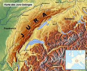
The mountain region Swiss Jura in the northwest of the Switzerland includes the cantons law, Neuchâtel and Basel-Country as well as parts of the cantons Bern, Solothurn, Aargau, Vaud and Zurich.
In the south, the mountains have striking, elongated mountain chains that are cut through by several transverse valleys. This area is geographic Chain Jura called. Towards the northeast, the mountains rise significantly less high and, in addition to individual mountains, some high plateaus have formed; this part of the mountain is called Table Jura.
background
The Swiss Jura is not geographically separated from the French Jura, only by the national borders. The mountains and valleys continue on both sides of the political borders, so that some travel routes lead to beautiful destinations across the national border.
The region lies on the elongated southeastern edge of the Jura Mountains Southern foot of the Jura, which from Geneva to Baden has a large density of tourist destinations and a network of attractive waters - etrwa die Jurassic lakes - and is easily accessible by various means of transport.
Regions

- Vallée de Joux
 .
. 

 in the Wikidata database") is a completely closed high valley at around 1000 m above sea level. In summer, the Lac de Joux is a magnet for all kinds of water sports, while the surrounding, practically untouched Jura mountains invite you to go on long hikes. In winter, the topography of the valley and the Jura heights are ideal for cross-country skiing.
is a completely closed high valley at around 1000 m above sea level. In summer, the Lac de Joux is a magnet for all kinds of water sports, while the surrounding, practically untouched Jura mountains invite you to go on long hikes. In winter, the topography of the valley and the Jura heights are ideal for cross-country skiing. - Val de Travers
- Vallon de Saint-Imier
- Freiberg
- Ajoie
- Laufental
- Fricktal
- Southern foot of the Jura


places

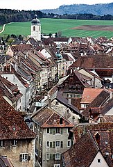
- 1 La Chaux-de-Fonds.

 The International Watch Museum is located near the train station.
 - 2 Saint-Ursanne. Location on Doubs, medieval collegiate church, beautiful town center with city gates, stone bridge.
- 3 Porrentruy. The grand prince-bishop's palace stands above the old town.
- 4 Delémont. In the old town, which still has old city gates, the former prince-bishop's castle, the Saint-Marcel church and the Jurassic Museum are particularly worth seeing.
- 5 Bärschwil. The Bärschwil geological hike shows interesting insights into the Solothurn Jura on 15 panels. Additional Information: Bärschwil.


- 6 Liestal. The canton capital of the canton of Baselland has a well-preserved old town with the city church and the Baselland Museum.

- 7 Laufenburg. an old city on Rhine in the canton of Aargau.
- 8 Brugg. City at the southern foot of the Jura with bridges over the Aare and historical buildings. Nearby is the Königsfelden monastery with valuable late medieval picture panels. Starting point for several post bus routes into the Jura.


.jpg/220px-Creux_du_Van_-_panoramio_(70).jpg)

Other goals
- 1 Creux du Van. is the largest gorge in the Jura Mountains and lies on the border of the cantons of Neuchâtel and Vaud. It measures 4 kilometers in length, 1200 meters in width and 500 meters in depth. The rock walls drop vertically 160 m. Chamois and ibex also live here. It can only be reached on foot.
- 2 Saut-du-Doubs. lies with Lac de Brenets in the Jura. You can climb it in Les Brenets ship, which leads across the lake to the Saut-du-Doubs. The Saut-du-Doubs is a waterfall that plunges 27 meters into the depth. The boat trip costs CHF 9 for a one-way trip, which takes around 20 minutes. The Saut-du-Doubs also forms the French / Swiss border here.

.jpg/350px-Le_saut_du_Doubs_(The_jump_of_the_Doubs).jpg)
- 3 Mont-Soleil. is a 1289 meter high mountain in the Bernese Jura near St-Imier. A Rack railway leads up the mountain. The operator's website is only in French. The journey takes only 4 minutes and the way from St-Imier station 12 minutes. The trip costs CHF 6.- for one trip.
- 4 Chasseral. is the highest mountain in the Bernese Jura and is famous for its view of the Swiss plateau and the Alps.
- 5 Réclère grotto, near Porrentruy. One of the largest stalactite caves in Switzerland open to visitors.


language
The western half of the Jura belongs to the French language area, to the east of which Swiss German is the colloquial language. The language border runs (from north to south) from Kleinlützel over the Scheltenpass and the Grenchenberg Biel. This city is bilingual.
getting there
Of Basel through the Laufental, the Ergolztal and the Fricktal by train, on motorways and cycle paths.
Of Zurich via the A 1 and A 3 motorways and by train via Baden AG and Brugg.
Of Bern on the highway Transjurans and by train via Biel or Neuchâtel.
mobility
- Several motorways, cantonal roads, railway lines and bicycle routes run through the Jura.
- The Jura heights are accessible on a good network of hiking trails.
- Cable cars lead to some mountains and beautiful viewpoints.

Tourist Attractions
- The underground 1 Mills of the Col-des-Roches, at Le Locle. are the only underground mills in Europe. Decommissioned at the end of the 19th century, some of them are now back in operation as an industrial museum.

- 2 Romainmôtier, Chemin derrière l’Église. Romanesque monastery complex near by Yverdon-les-Bains.
- 3 Augusta Raurica. An important site from the Roman period with extensive ancient ruins and an archeology museum.

_-_Amphiteatro.JPG/350px-Augusta_Raurica_-_Pratteln_(CH)_-_Amphiteatro.JPG)
activities
The Jura is a very beautiful hiking area at altitudes of around 600 to 1679 meters above sea level. There is one Jurahöhenweg, which mostly runs along the main ridge of the Jura. It begins in Dielsdorf near Zurich and leads through the warehouses, the Weissenstein, the Chasseral, Chaumont, La Dôle to Borex Geneva. It was originally marked with red and yellow rhombuses and today has the yellow signposts that are common in Switzerland. On some stretches, the path has similar requirements as a mountain hiking trail. So fitness and surefootedness are required. The whole route (with variants) is around 300 kilometers long and requires a pure hiking time of 90 hours.
The Jurahöhenweg also forms a section of the European long-distance hiking trail 4.
In winter, as soon as there is enough snow, the plateaus of the Jura are a paradise for cross-country skiers and snowshoe hikers.
kitchen
- Toétché - also called St. Martin's cake. It consists of an airy yeast dough with a salty cream filling. The casserole is often served as an aperitif and enjoyed with a Jura wine or local beer.
- Saucisse Ajoie - As the name suggests, this sausage is made in the Ajoie. The name is protected to ensure that it is made in the Porrentruy district and only with local ingredients. Today there are ten butchers who produce the sausage. It tastes like caraway seeds.
- Tete de Moine - The cheese was produced by the monks of the Bellelay monastery in the canton of Bern and is therefore more native to the Bernese Jura. It has been around for over 800 years and is the only AOC product in the Jura. A cheese dairy that also produces Tête de Moine is located in Saignelégier. It is served in rosettes.

Saucisse Ajoie

Tete de Moine


- Vacherin Mont d'Or: is a soft cheese made from cow's milk.
- Damassine is a brandy made from the damassine plum variety in the canton of Jura and mainly in the Ajoie. The damassine is the small plum that is pink-red on the sunny side and yellow-orange on the shady side. The yield of the trees varies from year to year. The fruits are hand picked as soon as they are ripe and fall to the ground. After the harvest, the fruits are completely filled into barrels without being pitted or crushed. They are then distilled in traditional stills to obtain a brandy with a minimum alcohol content of 40 °. This is after two to three years of storage eau-de-vie ripe for enjoyment.
- Macvin du Jura is a liqueur wine made from grape must and Marc, a pomace brandy. The grapes for this come from five grape varieties. Chardonnay and Savagnin are used for white Macvin, while Pinot Noir, Poulsard and Trousseau are used for red or rosé. The liqueur may be produced in the Jura wine-growing region, although the pomace brandy and grape must must come from the same company. This enables a variety of different tastes.

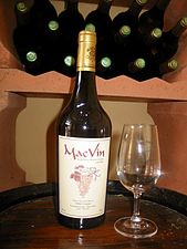
Macvin du Jura

trips
- The Rhine cycle route leads in the section of Bad Zurzach to Basel along the north side of the Jura.
literature
- Philipp Bachmann: Jura hiking: from the moated castle near Brugg to the Rhoneklus near Geneva. Zurich 2001, ISBN 3-85869-219-0 .
- Arnold Fuchs; Edmund van Hoorick: The Jura. Zurich 1986.
- Karl Karsch: The Swiss Jura and its fossils. Stuttgart 1981, ISBN ISBN 3-440-05003-3 .
- Max Mittler: Jura: the mountains and their inhabitants. Orell Füssli, Zurich 1987, ISBN 3-280-01626-6 .
- Margit Wagner: Jura: between the Rhine and the Rhone. Prestel, Munich 1987, ISBN 3-7913-0832-7 .