| Val Veny | |
 | |
| State | Italy |
|---|---|
| Region | Valle d'Aosta |
There Val Veny is a valley of the Val d'Aosta.
| ATTENTION: Some of the contents shown could generate dangerous situations or damage. The information is for illustrative purposes only, not exhortative or didactic. Use of Wikivoyage is at your own risk: read the warnings. | |
To know
It is part of the "Unité des Communes valdôtaines Valdigne-Mont-Blanc".
Geographical notes
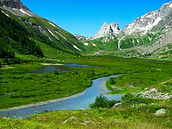
It is a straight glacial valley 13 km long, located north-west of the basin of Courmayeur. It is located at the foot of the Mont Blanc and constitutes it, together with the Val Ferret, its eastern geographical limit. It is crossed by the Dora di Veny.
It is divided into three main parts (starting from the upper valley):
- a part parallel to the chain of Mont Blanc, between the Col della Seigne (2,512 m) and the lower part of the Miage glacier]
- the intermediate part (plan Vény), characterized by the grassy plain and the river belt of the Dora di Veny;
- the entrance to the valley, dominated by Mont Blanc and the final part of the Brenva glacier (1,444 m).
On the right side of Val Vény, near Courmayeur, is the Lake of Chécrouit, placed at 2,165 m of height. On the opposite side of the valley you can see the Mont Blanc massif with the Dente del Gigante (4,013 m) and the Brenva glacier.
When to go
The valley is popular in both summer and winter.
Territories and tourist destinations
Urban centers
Other destinations
How to get


By plane
International airports of Turin Boxes, Geneva Cointrin and Milan Malpensa.
By car
- Until Courmayeur: via the A5 motorway Turin-Aosta-Courmayeur. For access from the Switzerland and from Northern Europe we recommend the Mont Blanc Tunnel, the Gran San Bernardo Pass or the Piccolo San Bernardo Pass (the latter open only in summer).
- From Courmayeur: Val Veny can be reached by a carriage road, which can be followed up to La Visaille, where the bus lines also end. From there on you can only proceed on foot or by bicycle. In winter the road is closed to cars.
On the train
Numerous daily trains connect the station of Pré-Saint-Didier (via the Aosta) with the Italian railway network. From Pré-Saint-Didier, a shuttle service is organized to Courmayeur to coincide with the arrivals and departures of the trains.
By bus
There are many buses from Aosta and other cities of the Piedmont, Lombardy is Liguria lead to Courmayeur. See the website of the Savda for timetables and routes. Bus line to Val Veny in the summer station: from the Mont Blanc square in Courmayeur to Visaille.
How to get around
On foot or by bike.
By bus
Line bus.
What see


- 1 Mont Blanc. The Mont Blanc chain acts as a backdrop like a natural amphitheater. With its peak of 4,810 meters, it is the highest peak in Europe. The mountaineering conquest of the summit of Mont Blanc took place as early as 1786, but still today its walls are a popular destination for mountaineers from all over the world.
- 2 Crossing of Mont Blanc by cable car (Skyway Mont Blanc), State Road 26, Pontal d’Entrèves area (Parking with 300 paid parking spaces and parking for coaches), ☎ 39 0165 89196, fax: 39 0165 89439, @[email protected].
 One way: from 12 €, round trip: from 28 €; day ticket: from € 57 (January 2018); for more details: rates.
  Typically 8: 30-16: 20; for more details: timetables. Nicknamed the eighth wonder of the world, the Glacier cable car allows you to reach Chamonix in the summertime. During the ascent, intermediate stops are made to admire the landscape from several points of view: at the first stop, at 2173 meters, there is the Saussurea botanical garden, the highest in Europe, while from the panoramic terrace of Punta Helbronner (3462 m) , you can enjoy one of the most spectacular views of the Alps. From Punta Helbronner you can reach the Aiguille du Midi, at 3842 meters, and descend to Chamonix or return to Courmayeur.
 - 3 Lake of the Miage (at 2,020 m). At the foot of the Mont Blanc massif.
- 4 Sanctuary of Notre-Dame de Guérison.
Itineraries
What to do

To facilitate hiking and climbing to the peaks, the valley is equipped with numerous shelters and bivouacs:
- 1 Mont Blanc Refuge (at 1,700 m). Easily accessible by car in summer and on skis in winter.
- 2 Elisabetta Soldini Refuge (at 2,195 m). Reachable from the end of Val Veny by car, then along the path you can reach the refuge in about two hours of walking.
- 3 Monzino Refuge (at 2,590 m). From Val Veny (Freney locality) in about three hours on foot.
At the table
Refer to the Courmayeur establishments. Typical dishes of the Aosta Valley cuisine: Aosta Valley roe deer, carbonada, Aosta Valley ribs, fondue, potato flan, Aosta Valley trout, Aosta Valley tiles.
Drinks
Aosta Valley coffee, genepì, grappa.
Safety
Hiking equipment (hiking boots, poles, backpack, windbreaker, goggles, hat, gloves, etc.) for high altitude ascents.