
The Via Pontica was an ancient Roman road connection on the western shore of the Black Sea (ancient Greek Pontos Euxeinos) and led by Byzantium (Istanbul) to the Danube-Delta. It connected Byzantium via the Danube Route (Via Istrum) and the Via Militaris With Rome.
background
Today the Via Pontica is part of a tour of the Balkans from a tourist point of view, e.g. if you are traveling from Belgrade to the Danube, or the Via Istrum drive along and then take Via Pontica towards Istanbul and either the Via Egnatia or the Via Militaris follows. On this round trip, culture and beach vacation can be combined well and is ideal for motorhome drivers. The Via Pontica leads to the best and most famous beaches and seaside resorts in Bulgaria and Romania (Black Sea) past .
Today, a north-south migration route for migratory birds that runs along the ancient road is also called Via Pontica.
preparation
Because of the many border crossings, it is important to find out about customs and traffic regulations in advance if you are traveling with your own vehicle. A few basic knowledge of the Cyrillic script makes a lot of things easier on site, as not all signs are always available in Latin script, especially away from the main roads.
getting there
- Car / mobile home: It is recommended to drive this tour with your own car. Because of the many border crossings, it is very problematic with a rental car, as few landlords allow border crossings.
- Bus / train: Alternatively, you can take the train-bus to the larger towns and from there you can take a rental car to the attractions and nature parks outside. Intercity buses connect all major towns in Bulgaria and also run along the coast.
Drive / let's go / ...


.jpg/400px-Yalıköy_(6).jpg)


.jpg/400px-Sunny_Beach_-_panoramio_(30).jpg)


Turkey
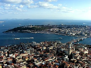
- 1 Istanbul
 (Истанбул, Byzantium, Constantinople).

 in the Wikidata database")

 Byzantium was the starting or end point of the route over the Via Pontica to Rome. Istanbul is one of the most interesting cities in Europe and you should plan several days for a visit.
 - 2 Rumelifeneri.Right at the mouth of the Bosphorus into the Black Sea, the village offers remarkable ruins of a fortress, a lighthouse (after which the modern village is named), and great views of the Bosphorus. According to ancient Greek myths, this place was home to the Symplegaden, "The Clashing Rocks", a pair of stones that constantly change their place and smash and smash every ship that is unlucky enough to have to go through here. According to the myth, Jason and the Argonauts were the first sailors to penetrate the Black Sea in search of the Golden Fleece. The steep rocky island next to the village, now connected to the mainland by the pier, is often considered the European of the two.
- 3 Kilyos / Kumköy.Roman: Kilios. Kilyos (or: Kumköy) is a small, quiet seaside resort. It has good bathing facilities and became a popular destination for a getaway among the residents of Istanbul in the 2010s. In the village there is a Genoese castle from the 14th century, which was restored at the time of the Ottoman Sultan Mahmud II. However, it is not open to the public as it is located in the military zone.
- 4 Karaburun (Карабурун).Roman: Philea. Seaside resort with many good beaches, but no real sights.
- 5 Yalıköy (Ялъкьой (Вилает Истанбул)).Roman: Podima. About 8 km east on the beach of Evcik Plajı you can still see the remains of the Anastasius barrier wall, which served to protect the capital Constantinople. It stretched from the Marmara Sea to the Black Sea. Yalıköy itself is a nice seaside resort with no other sights.
- 6 Kıyıköy (Мидия (Турция)).
 Roman: Medeia. It is a small village on the wooded Black Sea coast with a good marina and acceptable beaches. In the village you can still see the gates and walls of the Byzantine fortifications. In the area you can visit the old very interesting Byzantine monastery caves Aya Nikola with unusual stone furniture. It is the main attraction of the village.
 - 7 İğneada (Инеада).Roman: Staniera. Seaside resort with extensive beaches. The Black Sea is a bit dangerous here because of its strong currents.


Bulgaria.png/40px-Flag_of_Bulgaria_(bordered).png)
- 8 Eightopoly (Ахтопол)., the ancient Agatopolis. Remains of the city fortress, the 12th century monastery of St. Yani and a fountain with a carved rider are the only remains from ancient times. Another landmark is the Church of the Assumption from 1796. Today Akhtopol is a popular seaside resort with beautiful beaches and a marina.
- 9 Soosopol (Созопол). the ancient Apollonia Pontica. Today it is one of the most important seaside resorts in the country, known for the Apollonia Art and Film Festival. The old town is of particular tourist interest. The ancient and medieval cities were, like today's old town of Sozopol, on the Skamnij peninsula. The old town is characterized by narrow, steep cobblestone streets and characteristic houses and was declared an open-air museum in 1974 with its very interesting houses, the ethnographic museum, the art gallery, several churches and chapels as well as the remains of the former city monasteries and the city wall. Also worth seeing are the three small islands in front of the old town: Sweti Iwan, Sweti Petar and Sweti Kirik. The mountainous region around Sozopol is littered with over 1500 Thracian dolmens, necropolises and smaller barrows. However, these are still unexplored, in contrast to the necropolises of ancient Apollonia, which have been archaeologically studied since the 19th century.
- 10 Debt (Деултум).the ancient Deultum. (also Debeltos, Debeltus, Debeltum, Develtum, Develtus, Dibaltum), The place was initially a Thracian settlement on the western bank of the Mandra Lake at the mouth of the Sredezka River. A veteran colony was founded near them by Emperor Vespasian under the name Colonia Flavia Pacis Deultensium in 70 AD. It is located about 10 km west of today's Bulgarian port city of Burgas near the village of Debelt. In the area of the later Roman colony Deultum, traces of settlement have been found since the Late Bronze Age, then a Hallstatt Thracian settlement. In ancient times, Deultum was connected to the sea via the Mandra Lake, which then stretched further south. The excavation site and the museum are on the eastern edge of today's village.


.jpg/320px-Област_Бургас_-_Община_Средец_-_с._Дебелт_-_Античният_Деултум_-_(26).jpg)
- 11 Aquae Calidae (Акве Калиде).today mineral baths of Burgas. The warm springs have been used since the Neolithic and expanded by the Romans into a large bathing facility, which was also used and redesigned during the Byzantine and Ottoman times. The ruins are worth a visit. Today's baths are located in the middle of a spacious landscape park. There is a physiotherapy clinic, a health resort clinic, drinking water sources, an outdoor swimming pool with a hydrothermal pool, sanatoriums and rest homes.
- 12 Burgas (Бургас). the ancient Pirgos. Today's city has a Thracian-Roman origin and can be over 3000 years old history look back. The present city developed from several places in the area, the most important of which were Deultum, Poros and Aquae Calidae. Burgas is a well-known city for tourism beyond the region. The geographical location between several protected lakes, the Black Sea, the ancient and medieval archaeological sites and the festivals attract many visitors.
- 13 Pomorie (Поморие). the ancient Anchialus. Today's Pomorie can look back on a millennia of very changeable history look back. Today, Pomorie is surrounded by vineyards and orchards and is one of the most famous bog and seaside resorts in Bulgaria. The city center is located on the peninsula. In the old town there are still the typical cobblestone streets and the characteristic Black Sea houses from the 19th century in the style of the Bulgarian Revival - mostly roughly square, two-story houses with hipped roofs, the lower floor made of light stone, the upper floor made of dark painted wood is.
- 14 Nessebar (Old town of Nessebar).The ancient Mesambria. The city is located on the north side of the Bay of Burgas on a small rocky peninsula and, like all cities on the Black Sea coast, has a long and varied landscape history. Today it is a very popular seaside resort on Sunny Beach. Since 1983 the old town of Nessebar with its fortifications, the church buildings and the historical residential buildings has been a UNESCO World Heritage Site. The mountainous region north and west of Nessebar was predestined for the construction of fortresses and protective walls that protect the Via Pontica coastal road and the region from intruders from the north. In addition to the city fortifications of Nessebar, there are the remains of 20 other fortresses, 5 guard and protection towers and three earth walls in the region.


- 15 Dewnya (Девня).Roman: Marcianopolis. It was in the ancient capital of the Roman province of Moesia inferior (Lower Moesia) and temporarily the second capital of the Eastern Roman Empire. The place offers little touristic, but interesting is the stone forest (Dikilitash) approx. 15 km east of the city. Column-like rock formations cover a sandy area.

- 16 Varna (Варна). The ancient Odessos. Varna is the most important transport hub for the northeast of the country and has a lot to offer in terms of sights and entertainment. It is the most interesting city on the Bulgarian coast. The proximity to several summer health resorts turns Varna into a lively tourist center in the summer months. The port city is the cultural center of northeast Bulgaria and is known for its festivals. The city's archaeological museum also houses the world's oldest gold treasure.
- 17 Silistra (Силистра). Roman: Dorostorum. She belongs with her long history among the oldest Bulgarian cities. The large fortification (Medzhidi Tabia) from Turkish times is worth a visit. Here was a main branch over that Via Istrum along the Danube to Belgrade Via Militaris.
- 18 Kawarna (Каварна).the ancient Byzone. Kawarna was founded in the 5th century BC. Founded by Greek colonists who came from Mesambria (now Nessebar) - also a Greek colony. They founded the colony Bisone (also spelled Byzone or Bizone). The city puts its hope in the development of tourism, as it is located directly on the Black Sea. Currently, however, the beach of Kawarna consists only of a narrow, artificially raised strip of sand. The competition against the established “bed castles” of Albena (30 km southwest), Golden Sands (40 km southwest) and Sweti Konstantin and Elena (43 km southwest) is tough. These have a much nicer beach, are closer to Varna International Airport and have had a well-developed tourist infrastructure since 1960/70.
- 19 Kaliakra (Калиакра).A fortress has been located here along the Via Pontica since ancient times. It was called Tirisis by the Thracians and called Tirisis by the Romans Akra and under the Byzantines Akres Kastelum. In the Middle Ages, the strategically important fortress was named Kaliakra. The region has always been the bone of contention among residents and the great powers interested in the Black Sea. Cape Kaliakra has also been fortified repeatedly: the oldest fortifications come from the Thracians and date from around the 4th century BC. At a later time the Greeks took over the region and for over 200 years, the Romans. Today the rugged cape with its fortress ruins is a popular destination for tourists.


Romania

- 20 Mangalia (Мангалия).The ancient Kallatis. The city was founded in the late 6th century BC. Founded as a colony by Doric Greeks. From a historical point of view, it was one of the most important ports on the west coast of the Black Sea. Today Mangalia is a health resort and destination for sea vacationers. The city is also home to the oldest surviving mosque in Romania and an archaeological museum. In the newly built Hotel President you can visit interesting excavations of the ancient city in the basement.
- 21 Constanta (Кюстенджа). the ancient Tomoi or Tomis. Constanța was founded as a city almost 2,600 years ago and with 400,000 inhabitants is the oldest attested city in Romania, the largest port on the Black Sea (third largest in Europe) and also the fourth largest city in Romania. Constanța was founded by the Greeks as a port on the Black Sea coast for trade with inland peoples and was called Tomis (6th century BC). The city was later renamed after Constantina, niece of Constantine the Great (274-337). In the 10th and 11th centuries it was a thriving port city that traded with the Byzantine Empire and the city of Genoa. In 1420 it fell to the Ottoman Empire. During World War II Constanta was the target of heavy bombing by the Allies, where much of the old buildings were destroyed. Some well-preserved buildings and some museums are of tourist interest.
- 22 Histria (Истрия, Istria).the ancient Istros. The historic village has to offer today only the very interesting ruins and its proximity to Wolf's Hill National Park.
- 23 Troesmis (Троезмис).Troesmis was an ancient Roman city and military camp on the right bank of the Lower Danube, where you can visit the ancient site today.


security
see corresponding country articles: Turkey, Bulgaria, Romania.
trips


.jpg/400px-ÇilingozNaturePark_(3).jpg)
.JPG/400px-İğneadaFloodplainForestsNP_(11).JPG)


.jpg/400px-The_Fairy_Castle_in_Ravadinovo_(9902573066).jpg)


A little off the route of the Via Pontica are some very well-known sights or nature reserves.
TURKEY
- 1 Yoros Castle (Yoros castle ruins).Yoros Castle is a Byzantine castle ruin at the confluence of the Bosphorus and Black Sea north of Joshua's hill. It is also commonly referred to as the Genoese Castle since Genoa owned it in the mid-15th century.
- 1 Çilingoz Nature Park.The region was declared a nature reserve in 2005 because of its rich flora and fauna. The nature park is a combination of beach, forest, lake and reeds.
- 2 İğneada Swamp National Park.The country is mainly covered by oak forests, [2] the typical flora of the Yıldız Mountains. It is home to one of the few remaining large alluvial forests in all of Europe, which is home to many different species of birds.

.jpg/350px-ÇilingozNaturePark_(3).jpg)
.JPG/157px-İğneadaFloodplainForestsNP_(15).JPG)
BULGARIA
- 3 Strandzha Nature Park (Странджа (природен парк)).It is the largest protected area in Bulgaria with an area of 1,161 square kilometers in the Strandzha Mountains in the extreme southeast of the country on the border with Turkey. It was established on January 25, 1995 to protect the ecosystems and biodiversity of European importance, as well as the traditional cultural, historical and folkloric heritage of the region. 80% of the park area is covered with forests, 30% of which are primeval forests. These forests are the last remaining temperate forests with evergreen laurel growth in Europe. The park has the highest number of vertebrate species of any protected area in Bulgaria.
- 2 Mishkova niva (Мишкова нива).The sanctuary is part of a large Thracian complex consisting of a fortress on the Golyamo Gradishte peak, mines in the promontory, a hill necropolis, fortified buildings and remains of dwellings. The remains of a large, round Thracian fortress are located on the highest point of the Bulgarian Strandzha Mountains - the Golyamo Gradishte peak (710 m above sea level), next to the Mishkova Niva area.
- 3 Beglik Tash (Бегликташ).Beglik Tash is a prehistoric rock sanctuary and was reused by the Thracian tribes in the Iron Age. Most of the megaliths have traces of rock carvings used for Thracian rituals. Remains of a labyrinth through which visitors can walk and a Thracian sundial made of huge stones, a 150-ton rock that only rests on the ground in two places and a "uterine cavity" are other attractions. Every day at noon a ray of sun enters the narrow entrance of the cave and shines on the back of the cave and was considered by the Thracians as the symbolic fertilization of the womb or the mother goddess by the sun phallus of the sun god. Beglik Tash is located near two other Thracian sites: the city of Ranuli and the Pharmakida fortress in the Strandhza Mountains. The rock formation is approx. 3 km away Lion headthat resembles a lion's head. The lion's head is best seen from the Ropotamo River. It is a place where the Thracians had their fortress called Ranuli. If you want to hike up, follow the hiking trail with blue markings at the parking lot in front of Beglik Tas. Located about 1.5 km away from Beglik Tash Dolmen Dragon House, a completely preserved ten meter high megalithic construction of the ancient Thracians from the 13th century BC, untouched by looters. The peculiar mausoleum was built from perfectly coordinated boulders.
- 4 Thracian Propada sanctuary (Пропада).The Thracian necropolis in Propada is 3 km northwest of the city of Malko Turnovo. It is a typical example of Thracian cult architecture. The complex combines 4 different types of tombs that date from the II - IV centuries AD. The architecture of the entire complex shows the transition from dolmens to stone tombs.


.jpg/320px-Mishkova_niva_Strandzha_BG_(2).jpg)

- 4 Nature Conservation Center Poda (Пода).The nature reserve Poda is part of the Burgas wetland and you can admire the abundance of birds all year round. During the migration period, flocks of pelicans and birds of prey can be seen. Nutrias will also find plenty of food and can be observed. During the breeding season, the observer has the opportunity to observe mixed colonies of shovelers, ibises, gray herons, small, white, red and evening herons. Burgas is also known as the setting for the migration of storks and birds of prey. Eight train routes cross over the city of Burgas. During the migration period, huge flocks of white and black storks, pink and Dalmatian pelicans, lesser spotted eagles, wasp buzzards, limicoles, gulls and terns and many other bird species can be observed. The best time for bird migration is: Spring migration: Late March to mid-May. Autumn migration: Late August to mid-October. During the autumn migration alone, up to 300,000 white storks and 30 species of birds of prey fly over the city and its surroundings.
- 6 Aladja monastery (Аладжа манастир).Worth seeing cave monastery.


ROMANIA
- 5 Wolf's Hill National Park
- 6 Periteaşca-Leahova National Reserve
- 7 Babadag Forest Nature Reserve (Babadag Forest Nature Reserve)
- 7 Enisala fortress (Enisala fortress).Castle ruins from the 14th century, situated on a hill, surrounded by two lakes.
- 8 Adamclisi (Civitas Tropaensium).Roman settlement, the place is famous for its monument, the Tropaeum Traiani.


literature
- The Byzantine Road system in Eastern Thrace: Some Remarks, Andreas Kuelzer, 2011.