
The Allier is the largest tributary of the with a length of 410 km Loire and is one of the few still practically unspoilt rivers in France. It rises in the Lozère department and flows through the river to its confluence with the Loire, a little downstream from Nevers Auvergne. After a wild river stretch it offers whitewater of varying levels of difficulty from km 48 - 102, on the last 250 km from km 155 as whitewater I - tame water as a hiking river, with some caution, it is well navigable.
background

The Allier is one of the last and most beautiful natural rivers in France and flows through the Auvergne from south to north as a tributary of the Loire. In its bed it forms countless meanders, the gravel banks and steep banks form a habitat for a rich bird fauna - for the protection of which reserves have been set up in the lower reaches.
First of all, the Allier begins as a wild river that can be navigated in spring, turns into a challenging white water river when crossing the mountainous landscape of the southern Auvergne, and then descends Brioude (Km 150) into the lovelier landscapes of the Mittelauvergne and enters after the passage from Vichy into the plain of the Bourbonnais with wide floodplain forest areas, gravel banks and pasture areas, occasionally ("Loire") castles are visible in the distance.
In contrast to the Loire, the Allier was never used for commercial or passenger shipping, only very occasionally do you come across a motorboat used by fishermen. Due to the difficult logistics involved in collecting the vehicle and the low density of campsites, the Allier has so far been rarely used. Even in summer you only come across a few boats, and for reasons of environmental protection, canoe tourism is not explicitly promoted by the Allier department. So far, those responsible for tourism in the region have said that gentle tourism, the cruising of the river by environmentally conscious canoeists, who leave no visible residue or waste even after "wild camping", would enrich tourism in the Auvergne, which is rarely visited by guests apparently not recognized as such. At least there is practically no relief for canoeists when moving obstacles, in contrast to bicycle tourism, which has been very actively promoted in recent years, for which numerous cycle paths have been set up.
After a higher water level in spring, the Allier is mostly mobile from km 48 thanks to the water supply from several hydroelectric power stations in the upper reaches, the passability of the white water route from km 83-93 depends on the water supply from the Poutès power station.
In the lower reaches, the water level can be a bit scarce in hot, dry summers, the optimal line with sufficient current must then be chosen more carefully and navigating an arid tributary can end with the boat towing in ankle-deep water. After a violent summer thunderstorm, the water level can soon rise again to manageable heights.
The water is not very polluted except in the area of the cities, but it is practically always brownish - boggy in color, olive brown - cloudy after rainfall, so that the river bed and also the depth are often not recognizable.
preparation

Boat material:
- Section underflow from Vichy: The route can be traveled with kayaks and also with walking canoes (single and double) without any problems. Due to the boggy water, boulders in the water can often not be seen early, which makes the use of plastic boats (Royalex) preferred. It is also possible to drive on it with kevlar boats and folding canoes if you are careful.
- There is a danger in the lower reaches of dead trees, some of which can be below the water level and only draw attention to themselves through a somewhat teetering branch end protruding from the water. If you hit a log that is sloping with enough current, the hull of folding boats can be injured and the boat can capsize if the boat is overturned by the current. Since the water in the Allier is usually so shallow that you can stand, then in the best case only the equipment has to be collected and dried.
equipment: The equipment required in terms of clothing, safety equipment, provisions, etc. depends to a large extent on your own requirements as well as on the duration of the tour. In the interests of your own safety, it is strongly recommended to wear a life jacket / buoyancy aid on the Allier.
- For Day tours (Billy - Châtel-de-Neuvre, Châtel-de-Neuvre - Moulins, Moulins - Le-Veurdre, Le-Veurdre-Aprémont) can be started in the rental boat with little provisions and water, swimming trunks, sunscreen and a camera.

- Are particularly attractive Multi-day toursfor which all equipment must be carried. Then you need a tent (mosquito repellent), sleeping bag and mats, petrol or gas stove, water canister, possibly a water filter for water treatment, mosquito repellent, respectively. Incense coils, clothing, sun protection and water shoes - and the hiking canoe is quickly fully loaded. At least in Moulins you can shop at the supermarket near the weir by the bridge, otherwise drinks and food are best carried for several days at a time; the catering options are sparse.
- One of his own Boat cart is in the lower reaches especially when moving at the weir of Moulins extremely helpful. If you have to leave the boat unattended for shopping, a padlock and a chain / steel cable make sense.
Water level: The water level can be on Vigicrues can be queried online for different levels.
Accommodation and meals: There are few places to eat near the river, there are restaurants in Châtel-de-Neuvre (not open every day, distance to the river), in Moulins (but no tenting in the city), the Hotel la Chaumiere in Villeneuve-sur-Allier directly on the river and in Le-Veurdre.
- There are campsites in Châtel-de-Neuvre (near the river) and quite a distance from the river in Le-Veurdre, otherwise you have to camp in the wild near the river, or you can go on day trips with repatriation by the boat rental company.
- In the central Moulins there is only one left after the campsite closes RV park, apparently there will be no overnight stays in tents tolerated and camping canoe tourists also at night penalized and turned away.
Canoe rental (lower reaches)
Several boat rental companies offer hiking canoes and the corresponding packing barrels for rent, usually well-suited "Old Town Canadians" with paddle paddles are offered.
- Le Bureau des Guides de Loire et Allier, Canoe rental in Nevers (near the Allier estuary), Yvan Doirieux organizes not only Allier tours but also long-distance tours (onward journey on the Loire) with appropriate boat rental and pick-up on request.
- Canoe en Terre d'Allier in Le-Veurdre, canoe rental and return for allier tours and onward journey to La-Charité-sur-Loire, also accompanied.
- Club de Canoë Kayak de Moulins in Moulins, canoe rental and return for Allier tours, possibly accompanied.
getting there
Arrival (lower reaches): Section Vichy - Moulins - Allier estuary
The supply of the Allier department with public transport is - to put it mildly - quite wide-meshed.
The easiest way is to travel with your own vehicle and organize the boat rental and return with one of the landlords active on the river, who also cater to individual requests for multi-day tours.
The region Vichy - Moulins - Nevers is best over from Switzerland and southern Germany Basel - A36 - Besançon - A6 - Chalon-sur-Saône - N80 / N70 / N79 (not subject to toll, partly double-lane expressway, partly country road) can be reached within 4 1/2 hours (around 450 km).
Nevers - Moulins - Vichy are by a line of SNCF connected, the train stations are a bit apart, the river can be reached in 15-20 minutes on foot. A bus line runs along the Allier from Trans'Allier, but during the holiday season only one bus runs daily via Châtel-de-Neuvre ...
Recommended for individual travelers who want to cruise the Allier with their own boat, on the Camping "La Courtine" to stop in Châtel-de-Neuvre. The seat owner Norbert Niem organizes the return with his own vehicle upon reservation and also supports the tour planning (contact with boat rental companies, where necessary), all in German, which makes communication much easier.
Rules of conduct on the Allier

- commercial river navigation is not practiced on the Allier. During the day you only come across a few other hiking boats.
- the Life jacket to wear is especially for inexperienced swimmers and in the area of bridges and weirs Mandatory! Critical in this regard are Vichy, the weir at the bridge of Moulins (usually not drivable with hiking boats, absolutely visit left bank) and the weirs between Aprémont and the Allier estuary (definitely visit!).
- Particular attention should be paid to "dead trees" in the lower reaches. Some of the trees that were swept along by the last flood are just below the surface of the water and only draw attention to themselves through a small end of a branch bobbing in the current. When driving up, the boat may be lifted diagonally out of the water on the slippery tree trunk by the current and overturned.
Allier river description (lower reaches)

Vichy (Billy) - Châtel-de-Neuvre (42/25 km)

_117.jpg/210px-Pont_de_l'Europe_(Vichy)_117.jpg)

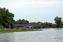
- 290.1 km - 1 Pont de l'Europe, Bridge of the D6, a bridge with a 10 m high weir that connects the Allier to the Lac de Vichy accumulates with the rowing regatta course is impassable. A slalom track has been set up on the left bank for training racing kayakers, but it is only possible to move carts in this area, the routes are long - your own boat car is required.
- Km 293 - 2 Bridge of the D27, three lobes
- Place on the left Charmeil, on the right industrial suburbs of Vichy.
- 299.5 km - 3 Bridge of the D67, behind 4 Railway bridge and weir, heavily blocked.
- Weir, possibly mobile in the 4th yoke from the right (i.e. left bank), visit! Alternatively, carry around on the left bank.
- 304.5 km - 5 Weir just before the road bridge from Billy.
- At most, it can be viewed through the passage on the right-hand side. Alternatively, transfer to the right bank of the gravel road.
Due to the technical challenges (moving the weirs), driving on the section is Vichy - Billy can only be recommended if you have already started the journey before Vichy or if you have decided to start the tour in Vichy (with its good rail connections).


At the moment the detailed river description is limited to the section Billy - Allier estuary:
- 304.7 km - 6 Bridge D130 : Billy on the right: medieval place with the 7 Château de Billy from the 13th century
- Can be used on the right bank below the weir, a gravel road on the right bank of the D130 leads to a good one 1 Launch site
 .
.

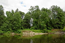


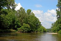
The following stretch of the river is lonely and nature is hardly affected by human influences, the river often runs in loops with gravel banks on the inner curves.
The nature is impressive, gray herons (or herons) fly up from the trees again and again, you regularly see little egrets with black bills and yellow "slippers", sand martins flying out of the holes in the sandy bottom on the steep banks. Occasionally one can encounter deer at dusk or watch beavers. At the railway bridge below the Chazeuil bridge there are countless bee-eater nests on the right in the high bank walls. And on the sand and gravel surfaces, unfortunately only sporadically, the now protected common terns, French "sternes", which is why staying there from April to the beginning of August is prohibited by law along the entire length of the Loire and Allier. The bird sanctuary, starting with this railway bridge, stretches for 25 km and ends opposite Bresolles with the 2nd electric overhead line, after you drove under the RN79, at the 2 red and white electricity pylons.
- 306.8 km: when branching into side arms 8 Torrent through rocks
- Km 317 - 1 Varennes-sur-Allier : Locality with supply possibilities and 2 railway station (Line Moulins - Vichy). Direct access from the river is difficult because the river Valençon on the right bank a stretch runs parallel and there are no crossing paths. The easiest way to get to Varennes is from the road bridge of the D46 downstream, but then 4 km resp. 60 min. Walk ...
- 318.4 km - 9 Bridge D46 : after the bridge on the right bank of the gravel road with access to street level

- Km 322 - 3 Railway bridge
- The nature reserve begins here Reserve Naturelle du Val d'Allier, on whose territory there is an absolute ban on tents and overnight stays, which is also enforced. Overnight stays for the next 25 km are only possible at the Châtel-de-Neuvre campsites.
- 325.4 km - 10 Sioule from the left
- 326.5 km - 2 Monetay-sur-Allier lies high above the left bank and an oxbow lake, from here a beautiful view of the Allier, but no river access.


- 330.1 km - 11 Bridge of the D32 between 12 Châtel-de-Neuvre left and the one lying a little further on the right la-Ferté-Hauterive (is just next to the N7).
- Immediately below the bridge on the left bank a suitable one 4 Launch site at a rest area, with a height limit barrier against mobile homes. Owners of VW buses or similar have to transport the boats 50 m to the river with the boat wagon, starting from the right bank via a steep fishing path is laborious.
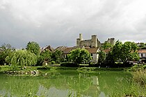
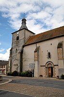
- Châtel-de-Neuvre itself is located on a hill 500 m from the river, here bakery, bar, small grocery store, bistro, tobacco office, post office and car repair shop. The Romanesque tower towering over the Allier on a knoll is worth seeing 13 Église Saint-Laurent from the 11th / 12th Century, good vantage point.
- 1 Camping "La Courtine", Châtel-de-Neuvre, 7, Rue de St. Laurent, La Courtine, F-03500 Châtel-de-Neuvre. Tel.: 33 (0)4 70 42 06 21, 33 (0)4 70 42 82 89, Mobile: 33 (0)6 24 93 01 35, Email: [email protected].
- for German-speaking paddlers very much recommended campsite (simple, but clean, geared towards ecological operation), as the owner Norbert Niem has already organized countless paddlers Allier trips thanks to his German mother tongue and excellent knowledge of the river. Especially for all paddlers who are not so "on you" with French, it is advisable to organize a boat rental through him, at a very reasonable price he also offers repatriations with your own car on the entire Allier or Loire stretch of up to 300 km Distance, as the tight connections with public transport during the summer holidays in Allier / Loire can otherwise make it logistically difficult to retrieve the vehicle. Before you plan to explore the Allier and Loire, it is also worth making a telephone inquiry about the water level of the Allier and whether it is navigable. But you can also Châtel-de-Neuvre water level View it online, and no problem up to minus 120 cm. Via the "back exit" of the camping 50m Wiesenweg to the deployment point on the Allier, boat wagon helpful, huge wheelbarrow and tractor available. Fishing permits can be bought from Mr Niem or from home on the HP: www.cartedepeche.fr, which can be switched to German, created and paid for online.
- 2 Camping Deneuvre, Route de Moulins, F-03500 Châtel-de-Neuvre. Tel.: 33(0)4 70 42 04 51, Fax: 33(0)9 72 25 62 63, Email: [email protected]. Relatively steep access to the river, at high / medium tide a bit difficult, at low tide over gravel bank.
Châtel-de-Neuvre - Moulins (20.5 km)


- 330.2 km left bank Insertion point at the Camping "La Courtine" / Rest area, directly below the road bridge of the D32, at low tide you have to paddle a little upstream from the eddy at the starting point towards the middle of the river in order to bypass the gravel bank on the left side of the river.
- 330.6 km On the left bank, at low tide above a gravel bank, the tents of the are above the embankment Camping Deneuvre to recognize.


The Allier takes a course again with numerous loops with steep banks (with sand martin holes) on the outside and gravel banks on the inside.
The entire course up to the level of the railway bridge just before Moulins is now part of the Reserve Naturelle Val d'Allier: There is an absolute ban on free tents and bivouacs and open fire, no animals may be hunted (with the exception of fishermen with a corresponding fishing license) and no plants may be picked.
From the bank, some viewpoints allow access to the river, there are no supply or even refreshment stops along the route to Moulins (after all, a close day's tour)!


- 342.3 km - 14 Bridge of the N79 , easily mobile
- Km 347 - 5 End of the NSG Reserve Naturelle Val d'Allier marked by a sign on the left, about 100 m in front of the masts of the high-voltage line from Bressolles on the left bank, which are painted red and white on both sides of the bank (not visible from the river).


- 349.9 km - steely 15 Railway bridge, Beginning of the urban area of Moulins.


- 350.5 km - 16 Watering point and location of Boat rentalClub de Canoë Kayak de Moulins


- 350.8 km - 17 Pont Régemortes =, Road bridge D2009: the Arch bridge with the one behind it Weir is practically impassable for hiking boats (rental boats keep bumpy over the steps ...). Before moving, it is best to land on the left bank in the area of the watering-out point of the ASPTT boat rental and explore the situation, which can be very different depending on the water level. The following options are available for implementation:
- To cart on the left bank with your own Boat cart (Barely manageable with the fully loaded boat without a car due to the distance of 650 m): from the launch point you can roll up the ascending road to the D2009, at the roadside you go over the roundabout and through a small park to a driveway, which unfortunately has a few Ends in gravel and sand banks meters before the river bed; the boat trolley likes to sink here ... Inserting it in the underwater on the left is then unproblematic, in good weather there are always numerous local bathers here. Boats rented by the ASPTT will be transferred by the canoe club when they arrive in the afternoon.
- Carrying around on the left bank, drive approx. 20 m in front of the bridge and wash out. Paved stairs to the bridge up, 50 m after the bridge sandy dirt road to the outlet of the fish ladder.
- Towing via the so-called "Fish ladder" on the left in the first arch of the bridge. The boat has to slide down a few stone / concrete steps 30-80 cm high. Since damage often occurs with a fully loaded boat, many canoeists unload the luggage at the base of the first bridge pillar and carry it down on the concrete / stone wall, where the water is calm before it can set in; Then only the empty boat on the right wall is grained. With children, such a relocation on the slippery pillar base seems a dangerous undertaking. When the water level is higher, however, like in spring after the snow has melted, even loaded hiking canoes can use this fish ladder without any problems.
- Towing via the so-called "canoe passage" on the right in the first arch of the bridge; half covered by boulders so that the boat can tip over or wedge itself in the bridges in the middle of the step.
- of any Overbearing Thinking of the weir in the middle is unrealistic, even when the water level is low, due to the large boulders that make up the weir, which are difficult to climb over.

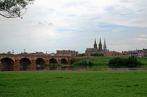
Moulins with a population of over 20,000 is located on the right bank of the Allier, the 301 m long, thirteen-arched bridge was built by engineer de Régesmortes in 1753/63 and leads to the city center. It is worth seeing Notre Dame de Moulins Cathedral with the late Gothic choir from the 15th century, the facade with the pointed towers as well as the neo-Gothic church Sacré-Coeur (which is a little closer to the Allier) with also two pointed towers date from the 19th century. The 6 railway station is located east of the city center, approx. 1.5 km / 20 min. from the river.
The city invites you to stroll and shop, the Intermarché, ideally located on the left bank of the Allier just below the bridge (or on the slope above the deployment point) for supply, with toilet and fresh water tap to fill up with water, is extremely practical. A supermarket of a similar size and suitable location will no longer be encountered up to the confluence of the Allier in the Loire, at the latest here drinks and food should be bought for the following days on multi-day tours.
The area of the former campsite at the disembarkation point and the Moulins canoe rental, the ASPTT, can still be identified. Unfortunately, it was abandoned and replaced by a self-service camper space. The camper vans meet optimal conditions here, camping is unfortunately under threat of a bus 25 € / person Prohibited in the local boundaries of Moulins, ie from high-rise buildings in front of the 1st (railway) bridge to the point after the 2nd (car) bridge, where the river takes a noticeable left curve and the steep, bushy bank begins on the right; According to reports, police evictions at night by the gendarmerie, Police Nationale, Police Municipale, forest, water and environmental officials are to be expected. Bathing in the river is also forbidden in Moulins and is included 35 € / person punished.

Moulins - Le-Veurdre (31.8 km)


- 350.8 km - Stone arch bridge "Pont Régemortes", Moulins, with weir
After the weir at the bridge of Moulins has hopefully been carried or grained dry and intact, one of the Allier leads you back through untouched nature shortly after the urban area. Apart from a few other canoeists, a few fishermen and, in midsummer, bathers in the area of the road bridges, there are hardly any people.
The nature is impressive, you can see numerous gray and little egrets, sand martins, and occasionally a kingfisher flies away from its perch on a branch just above the water level, so quickly that you can hardly get it in front of your lens. The banks are often lined with trees, you can see mullein, the light yellow evening primrose, which only opened their flowers at dusk, then again cow pastures with the bright Charolais cattle, which have fenced-off drinking troughs on the banks.
After the Allier leaves the urban area of Moulins, you can camp freely on the banks or. to be bivouacked. The strict regulations of the nature reserve no longer exist, but here too it goes without saying that plants and animals are spared, no open fires are kindled in summer when it is dry and no waste is left behind on the river.
After summer thunderstorms, the water level can rise rapidly. When the water is low in periods of low rainfall in midsummer, it is worthwhile to read the flow of the river well and only enter a picturesque side arm near an island if there is enough depth with a sufficient current, otherwise you can go along at the lower end of the river arm Confronting shallow water and having to pull your boat over the pebbles - as a paddler you don't pull your boat into the water for a river hike.


- 363.4 km - 18 Bridge of the D133, easily passable.
- 19 Villeneuve-sur-Allier right bank, the place with approx. 1,000 inhabitants is marked by the leading through N7. There are a few bars and a bakery, at 1.7 km the place is relatively far from the river. Sights around the 14th century. established place are the 20 Church that 21 Château de Villars with appropriate accommodation as a gîte rural, the one in the south-east 22 Château du Riau also with befitting guest rooms and that 23 , a historical botanical garden laid out around the Château de Balaine in the northeast of the town, is well worth seeing.
- The station 7 Villeneuve-sur-Allier SNCF is on the line Nevers - Moulins.

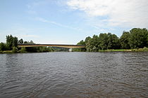
- 3 Hotel la Chaumiere, Le Pont, 03460 Villeneuve-sur-Allier. Tel.: 33 (0)4 70 43 30 35, Fax: 33 (0)4 70 43 32 36. Hotel and restaurant, located right next to the bridge on the right bank of the Allier, direct access from the river via steps in the garden; as the only hotel accommodation located on the river worth mentioning far and wide. Possibility to ask for fresh water.


Over the next 20 km, the Allier runs partly with islands and side arms through agricultural land. In some cases, cow pastures with drinking troughs reach the river bank, in some cases tree-lined steep banks and gravel banks and islands.


- 382.6 km - 24 Road bridge of the D978a
- The left arch of the bridge is easy to drive, the middle one is overgrown and impassable when the water is low, and there are problems with steps and piles when the water is low.
- On the left behind the arch of the bridge there is the embarkation point, in a shed immediately behind the canoe rental Canoe en Terre d'Allier by Le Veurdre.


.jpg/210px-Le_Veurdre_Eglise_(3).jpg)
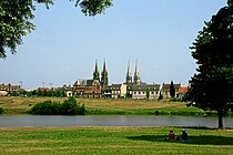
The locality 3 Le Veurdre is to the west, about 800 m away. In the place with its approx. 500 inhabitants there is a bakery, a butcher, a grocery store (closed Wednesday) and that Hôtel-Restaurant du Pont Neuf.

- Worth seeing in the place is the originally from the 11th century. originating Romanesque church 25 Église Saint-Hippolyte with the church tower from the 15th century, the 26 Château de la Beaume and the 27 Château de La Charnée from the 18./19. Century
- The concrete bridge built after 1910 was the scene of clashes in World War II when a French detachment tried to stop the advance of German troops across the Allier Bridge 28 Memorial stone recalls these events. The bridge that was blown up in 1944 was replaced by a new reinforced concrete bridge built on the old concrete foundations.
- 4 Camping municipal Saint-Mayeul / Le Veurdre, Rue de Saint-Mayeul, F-03320 Le Veurdre. Tel.: 33 (0)4 70 66 40 67, Fax: 33 (0)4 70 66 42 88. Inexpensive, but a bit far from the river at 1.6 km, therefore less suitable for paddlers in transit than for those who want to start or end a trip here.Open: 15.6.-15.9.


Le Veurdre - Aprémont / Bec d'Allier (19.7 / 25.6 km)
- 382.6 km - Bridge of the D978: Insertion point on the left bank below the bridge
The last section of the Allier tour continues through a largely untouched river landscape, side arms (sometimes barely navigable when the water is low) lead around river islands, some with tree-lined high banks, some with gravel banks. Again and again pastures and cattle watering reach up to the river. The bird life on this section of the river is also fascinating. Below Le Veurdre, the stork territory begins, which like to make their nests on dead trees. Herons and little egrets are also common; on branches a little above the water, kingfishers wait for prey and when approaching they fly away rapidly with a flat trajectory just above the water to disappear into the undergrowth.
At the picturesque, somewhat museum-like village of Aprémont, which attracts numerous visitors with its castle and the "Parc Floral" flower garden, the Allier trip can easily be ended. However, the place is hardly accessible by public transport, so that the return must be organized by car; the last kilometers of the river to the confluence of the Allier in the Loire at the "Bec d'Allier" are not very scenic, but are problematic due to the three weirs that are not harmless and difficult to move. A further journey to the Loire estuary is actually only worthwhile if you intend to continue the journey directly on the Loire.
- 389.9 km - 29 Bridge of the N76 / D2076


- Modern bridge, easy to drive on the left, the right arm of the river behind an island can become shallow at low tide, the middle bridge pillar of the bridge is on a river island.
- 30 Mornay-sur-Allier, Landstrasse D 2076, liegt links ca. 800m vom Fluss entfernt, keine Geschäfte oder Kneipen mehr, alles auf ewig geschlossen! Will man überhaupt ins Dorf, dann keinesfalls die starkbefahrene D2076 hoch, sondern nach links über den halbmondartig führenden geterrten Landwirtschaftsweg, der auch an dem kleinen, weiter unten genannten Municipalcamping vorbeiführt. In Mornay ganz liebe hilfsbereite Menschen, der berühmte Wein und die Kirche.
- 5 Camping municipal La Bruyère, 76 La Bruyère, F-18600 Mornay-sur-Allier. Tel.: 33 (0)2 48 74 56 07.

Im Verlauf führt die Flussstrecke weiterhin durch landwirtschaftliches Gebiet, man begegnet kaum Menschen und paddelt an isolierten Gehöften vorbei.
- Km 401,5 - am rechten Ufer liegt das vom Fluß aus gesehen sanierungsbedürftige Château de Meauce, das von der Landseite intakt und voll schön und interessant erscheint, ein echter Hingucker! In diesem Bereich hält man sich besser rechts, links oft seichtes Wasser, bei Niedrigwasser schlecht zu fahren.


- Km 402,3 - Apremont
Das museal anmutende Dorf 31 Apremont-sur-Allier mit seinem Château liegt am linken Flussufer, es gibt hier keinen Brückenübergang ans rechte Ufer, wo allenfalls auf Kiesbänden gerastet oder übernachtet werden könnte.
- Eine gute Ausbootstelle findet sich gleich beim Ortseingang bei einem einmündenden Bachlauf (Kanuparkplätze sind mit Schild markiert), über ein steiles Ufer kann das Boot auf Strassenniveau angehoben werden, in der Nähe der Parkplätze und der Barriere, welche die Zufahrt zur Fussgängerpromenade verhindert. Entlang des Allierverlaufs kann weiter flussabwärts entlang des Orts kaum ausgewassert werden, zudem ist eine Zufahrt zur Bootsrückholung dorthin nicht möglich.
Dem Ort Apremont, in den historischen Gebäuden leben heute etwa 75 Einwohner, wurde unter dem Schlossbesitzer Eugène Schneider um 1930 der heutige Aspekt verliehen, indem die Gebäude saniert, unpassende Bauten abgerissen und durch Gebäude in einem an die mittelalterliche Vergangenheit anlehnenden Stil ersetzt wurden. Das Schloss wurde schrittweise saniert und um 1970 der "Parc Floral" an künstlich aufgestauten Teichen errichtet, der Park mit seiner abwechselnd blühenden Bepflanzung wurde zum Besuchermagnet.
- Im Ort findet sich die Gastwirtschaft "Brasserie du Lavoir" und eine weitere Kneipe, in der auch Eis erhältlich ist; ein Andenkenshop im Eingangsgebäude zum Parc Floral, ansonsten aber keine weiteren Einkaufs- oder Unterkunftsmöglichkeiten. Öffentliche Toiletten mit Frischwasserhahn beim Uferweg. Sehenswert ist das Ortsensemble mit den historischen und historisierenden Gebäuden, die dem Allier entlang führende Fussgängerpromenade ist verkehrsbefreit.
- Das Schloss ist weiterhin im Besitz der Familie de Brissac. Zu besichtigen ist der Parc Floral mit der chinesischen Pagodenbrücke, Pavillons und zahlreichen seltenen Blütenpflanzen und Sträuchern und Bäumen, daneben gibt es in den Stallungen des Schlosses eine Sammlung von neun Kutschen aus den vergangenen Jahrhunderten zu sehen.
- Parc Floral d'Apremont, Le Bourg, F-18150 Apremont-sur-Allier. Tel.: 33 (0)2 48 77 55 00, Email: [email protected]. Geöffnet: Mitte April - Ende Sept., 10.30-12.30, 14.00-18.00h.Preis: 10.00/7.00€ (Parc und Kutschensammlung), 9.00/6.00€ Parc Floral.
Auf den sechs Kilometern Reststrecke bis zur Loiremündung folgen nun drei anspruchsvolle Wehre, welche alle nicht einfach zu umtragen sind, die Fahrt lohnt sich nur für diejenigen, welche planen, auf der Loire die Fahrt fortzusetzen.


- Km 404 - 32 Barrage des Lorrains / Prise d'eau des Lorrains: nicht fahrbar!

An der Barrage des Lorrains, hier findet sich auch eine historische Rundschleuse und Wasserentnahme zum "Canal lateral d'Alimentation", welcher den weiter flussabwärts den Allier überkreuzenden "Canal Latéral à la Loire" speist. Das Wehr wurde 2014/15 umgebaut.Finaler Stand August 2017: Das Wehr ist inzwischen fertiggestellt worden. Auf der rechten Seite wurde ein Kehrwasserbecken angelegt, wo auch ganz rechts in Ufernähe die Auswasserungsstelle für Kajaks und Canadier ist. Die Umtragestelle ist mit Schildern markiert. Bei normalem Wasserstand überläuft das Becken. Vorsicht! Die Plattform ist nur 3 Meter breit und direkt am Überlauf, der nicht befahren werden kann. (Scharfe Kanten) Über die drei Stufen einer Elephantentreppe ist kein Transportwagen zu benutzen. Wer also sein Boot liebt, lädt aus und trägt alles einzeln nach unten, wo ein ruhiges Wasser das Einladen leicht macht. Bei mehr Wasser ist ein Treideln vielleicht möglich. Leider wurde das Umfeld so verbaut. dass auch kein Umweg mehr mit einem Bootswagen möglich ist.Eine weitere Möglichkeit zu umtragen: Linksufrig: etwa 150 m vor dem Wehr, auf Höhe eines Gebäudes am linken! Strassenrand (nicht erst beim Pumpenhaus der Rundschleuse, hier Lebensgefahr! es hat 2016 hier einen tödlichen Unfall gegeben) kann auch bei höherem Wasserstand problemlos 33 ausgewassert werden, davor langsam knapp am linken Ufer paddeln. Mit dem Bootswagen muss das Boot dann eine grössere Strecke zum Einsetzen ins Unterwasser transportiert werden.
- Of the ersten Kanalbrücke ist der Allier relativ weit entfernt, eine anfänglich noch brauchbare (rollbare) Schotterstrasse verjüngt sich zu einem 34 Fussweg durchs Unterholz zum Fluss, das Einsetzen ist hier möglich, allerdings ist die kurze Strecke zum nächsten Wehr kaum den Aufwand wert.
- Auf der 35 zweiten Kanalbrücke kann der Seitenkanal überquert werden, eine Schotterstrasse führt unter einem Bogen der Eisenbahnbrücke hindurch und unmittelbar 36 hinter der Eisenbahnbrücke direkt zum Fluss und man erreicht eine geeignete 37 Einsetzstelle direkt im Unterwasser des Wehrs resp. der Stufe unterhalb der Eisenbahnviadukts. Mit der Umtragungsstrecke von 1,9 km hat man gleich zwei schwierige Stellen passiert, praktikabel allerdings nur mit Bootswagen, mit einem solchen dafür risikoarm.


- Km 405,5 - 38 Eisenbahnbrücke
- Unmittelbar hinter der Eisenbahnbrücke befindet sich eine Stufe mit Steinen und Pfählen, welche bei Hochwasser allenfalls gefahren werden kann, bei Mittel- und Niedrigwasser zu Problemen führt.
- Linksufrig kann etwa 50 m vor der Eisenbahnbrücke an einem Fischerstieg wenig komfortabel 39 ausgewassert und über einen teils stark verwachsenen (Brennesseln, Brombeerranken) Pfad, ab der Brücke dann einen gut breiten Weg umtragen werden, die Einsetzstelle ins Unterwasser am linken Ufer ist wie oben beschrieben gut erreichbar.


- Km 407 - 40 Aquädukt "Pont-Canal du Guétin" des Loire-Seitenkanals / Canal lateral à la Loire With Wehr, nicht fahrbar.
Das Wehr unmittelbar hinter der Kanalbrücke des Loireseitenkanals ist nicht fahrbar, linksseitig gibt es eine "Fischtreppe" mit hohen Stufen, welche mit dem Wanderboot nicht fahrbar ist.
- Rechtsufrig: etwas 5 m Meter vor dem rechten ersten Brückenbogen befindet sich ein kleines Hinterwasser mit einer brauchbaren 41 Auswasserungsstelle, das Boot muss allerdings über eine Stufe ca. 1 m hoch angehoben werden. Auf einem Fussweg resp. Schottersträsschen kann unter dem Viaduktbogen hindurchumfahren werden, zur 42 Einsetzstelle ins Unterwasser führt ebenfalls ein Fischerstieg mit einer Stufe, die nicht auf den Rädern des Bootswagens zu bewältigen ist, hier muss nochmals gehoben werden. Ganze Umtragungsstrecke ca. 40 m. Gemäss Beschreibung ist bei Niedrigwasser das rechte Ufer aufgrund einer Kiesinsel welche sich unterschiedlich nahe an den Aquädukt ausdehnt, teils nur schwer erreichbar, bei höherem Wasserstand kein Problem.
- Linksufrig: da landseitig der Aquädukt keine Bögen aufweist, durch welche die Brücke umfahren werden kann, wird am besten bei einem kleinen Kehrwasser unmittelbar unter/nach dem ersten Brückenbogen links 43 ausgewassert, was zumindest bei dem beobachteten mittleren Wasserstand möglich ist, bei Hochwasser kann die Strömung zu stark auf die Fischtreppe ziehen. Auf einem Fussweg wird links die Fischtreppe mit ihren teils hohen Stufen links umtragen oder etwas holprig mit dem Bootswagen umkarrt, bis zum 44 Unterwasser bei einer Kies-/Sandbank ca. 60 m weit.
Da die Situation je nach Wasserstand sich stark von der beschriebenen unterscheiden kann, sollte die Situation vor Ort unbedingt vorgängig besichtigt werden!


Le Guétin mit der Kanalbrücke Pont Canal: gegenüber der Gaststätte Auberge du Pont Canal kann problemlos parkiert werden. Oftmals beobachten viele Schaulustige das Schleusen der Hausboote auf dem Loire-Seitenkanal, die den Allier auf dem Aquädukt überqueren; links des Kanals können Fussgänger zur Besichtigung den Aquädukt auf einem Fussweg überqueren.
- 1 Auberge du Pont Canal, Le Guetin, F-18150 Cuffy. Tel.: 33 (0)2 48 80 40 76, Fax: 33 (0)2 48 80 45 11.

- Km 407,1 - 45 Strassenbrücke D976
- Die moderne Strassenbrücke zwischen dem linken Allierufer / Le Guétin und dem kleinen Ort Gimouille rechtsufrig, die Strasse führt weiter nach Nevers, ist problemlos zu passieren.
- Km 408,2 - Alliermündung 46 Le Bec d'Allier
- Nach einem weiteren Kilometer mündet der Allier in die Loire. Das Gebiet der Mündung wurde unter Schutz gestellt, rechts an der Mündung findet sich ein Vogel-Beobachtungspunkt.
- Kurz nach der Mündung kann linksseitig im Bereich einer Kuhweide 8 ausgewassert werden, das Boot muss auf einer Schotterstrasse mit dem Bootswagen zur Strasse hinauf gezogen werden. Aufgrund einer Schranke kann mit dem Motorfahrzeug nicht zum Verlad zum Flussufer hinuntergefahren werden.
- Im kleinen Ort 4 Le Bec d'Allier befindet sich lediglich eine Bäckerei um den Brotbedarf zu decken, ansonsten keine Versorgungs- oder Übernachtungsmöglichkeiten.
Web links
- Naturreservat Val 'Allier, französisch, mit Übersichtsplan zum Download
- Ligue pour la Protection des Oiseaux Auvergne, die Vogelschutzorganisation informiert über die Fauna am Allier und unterhält online-Atlanten mit Beobachtungsmeldungen
- Trans'Allier, Informationen zum Busnetz im Departement Allier mit Fahrplänen.
literature
- DKV-Auslandsführer Band 6 (Nordfrankreich - Benelux), DKV-Verlag (4. Aufl., 2013), Hans Ramajzl, ISBN 978-3937743370
- Der Allier: Kanuführer von der Quelle bis zur Mündung, Martin Schulze, Pollner Verlag (2010), ISBN 978-3899610482