 | |
| Capital | Torshavn |
| currency | Faroe Islands Krona (FOK) 1 FOK = 1.0000 DKK |
| population | 52,154(2020) |
| Power Systems | 230 Volts / 50 Hz (European plug, Schuko, Type E, Type K) |
| country code | 298 |
| Time zone | UTC±00:00 |
| Language | Faroese, Danish |
| Emergency call | 112 |
| Driving direction | right |
| Edit on Wikidata | |
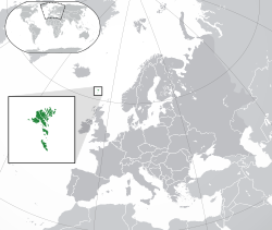
Faroe IslandsIs a Nordic countryDenmarkOverseas autonomous territories. Geographically located between the Norwegian Sea and the North Atlantic, inNorwayarriveIcelandHalf the distance between them. The Faroe Islands has a land area of 1,399 square kilometers and consists of 17 inhabited islands and several uninhabited islands. There are 46,662 inhabitants (estimated mid-2004). Most of the inhabitants are descendants of Scandinavians and members of the Christian Lutheran sect. The official language isFaroesewithDanish。
The residents of the Faroe Islands vote for the members of the Autonomous Assembly, and then the Prime Minister is elected by the Autonomous Assembly. The Danish government will send a high commissioner to the Faroe Islands to monitor the operation of the autonomous government, represent the Queen, and assist in the foreign affairs of the islands.
learn
history
Around 600 AD, a group of Irish monks settled here. In the 9th century AD, the Vikings invaded and occupied the Faroe Islands. A republic was once established in 970, but it was actually a vassal state of the Earl of Orkney in Scotland. In 1280, it became a Norwegian occupation with the Orkney Islands. In 1380 it was merged into Denmark with Norway. In 1650 it became the feudal territory of the Danish Von Gabel family (Von Gabel). In 1720, it was classified as an area under the jurisdiction of Iceland. In 1816, it was classified as an overseas county. After the defeat of Denmark at the beginning of the Second World War (1940~1945), the British army invaded the Faroe Islands. On March 30, 1948, the Faroe Islands was granted a high degree of autonomy by Denmark and became an overseas autonomous territory.
geography
The Faroe Islands is an island group composed of 18 main islands, about 655 kilometers away from Northern Europe, between the Norwegian Sea and the North Atlantic Ocean, approximately between Iceland and Norway, and close to Erianthir in Iceland and Scotland. The geographic coordinates are 62°00'N 06°47'W. It covers an area of 1,399 square kilometers (540 square miles), has no important lakes or rivers, and has 1,117 kilometers (694 miles) of coastline. Its only important uninhabited island is Lítla Dímun. The southernmost island, Suðuroy, the Faroe Islands is roughly rugged, rocky low mountains and rocky walls. The typical eroded landform during the glacial period is full of well-developed fjords and huge pyramid-shaped mountains. Its highest geographical point is the Slættaratindur mountain peak, which is 882 meters (2,894 feet) above sea level. Lapan basalt and volcanic rock are the main geology of this island, which is also part of the Thulean plateau in the Paleogene era.
climate
The warm North Atlantic current passes through the area, so it has a typical oceanic subpolar climate. The climate in winter is not very cold, with an average temperature of about 3 to 4 degrees Celsius; in summer, the climate is relatively cool, with an average temperature of about 9.5 to 10.5 degrees Celsius. Due to the path of low pressure moving northeast, the Faroe Islands has strong winds and heavy rains all year round. Sunny weather is very rare, with an average of 260 rainy days per year, and the rest are usually cloudy.
area
The archipelago is composed of 18 islands covering 1,399 km² (545.3 sq mi) and is 113 km (70 mi) long and 75 km (47 mi) wide. 17 islands are inhabited, leaving just one uninhabited island, the smallest island, Lítla Dímum . There are a lot of smaller islets and skerries around the Faroe Islands. Including the 18 islands there are 779 islands, islets and skerries in the Faroe Islands. A large part of these are around the island Suðuroy, which consists of 263 islets and skerries , including the island itself. The precipitous terrain limits habitation to small coastal lowlands. The islands are connected by tunnels, causeways and a regular public ferry service.

| Northern Islands The six Northern islands (Borðoy, Kunoy, Kalsoy, Viðoy, Svínoy and Fugloy) have made up one administrative area since Norse times. The volcanic origin of the Faroe Islands is more pronounced here than anywhere else. The landscape is very dramatic. |
| East Island The second largest island. The landscape in the north is very steep. |
| North Stromo Streymoy is the largest and main island. The north is less densely populated but there are some wonderful villages. |
| South Stromo Here the capital Tórshavn is situated and the area surrounding the capital is where the largest number of people live. |
| Vogar Island Vágar is the third largest island and is where the airport is situated. Mykines, the small island to the west, is well known for its bird life and remote location. |
| Sand Island The region is made up of three islands with the largest being Sandoy, the other two are Skúvoy and Stóra Dímun. |
| South Island The most southerly island and Lítla Dímun -the smallest island, which is uninhabited. |