 | ||
| Aldein | ||
| region | Trentino-South Tyrol | |
|---|---|---|
| Residents | 1.656 (2018) | |
| height | 1,225 m | |
| no tourist info on Wikidata: | ||
| location | ||
| ||

Aldein(Italian: Aldino) is a community in South Tyrolean lowlands and consists of the places 1 Aldein, 2 To fetch Holen and Radein, divided into Neuradein, 3 Unterradein and 4 Oberradein
background
The municipality of Aldein is located on the ridge of the Regglberg in the west of the Fleimstal Alps on the edge of the Adige Valley. At the foot of the 2,317 m high 1 Weisshorn originates from Bletterbach, it has dug a deep gorge over the course of millions of years, which since 2009 has become UNESCO World Heritage Site belongs. West of the small town To fetch the name of the stream changes to Schwarzenbach, it ends at Except into the Adige.
getting there
By plane
By train
The next train station is in Except
By bus
In the street
- On the
 Brenner motorway until the exit Neumarkt-Auer-Tramin, then continue on the
  Dolomite Road.
- After Aldein or Holen: continue to the Brückenwirt, then continue on the SP72.
- To Radein: on the Dolomite Road in the direction of Kaltenbrunn (Fontanefredde), then continue on the SP130.
mobility

Tourist Attractions

Churches
- 1 Parish church of Aldein. The church is St. Dedicated to Helena and the Apostle James.
- 2 Parish Church of St. Wolfgang
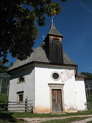
- 3 Maria Schnee chapel, Aldein
Museums
- 4 Village museum, on the 1st floor of the old school building. Museum of Sacred Art.Open: May-Oct Sat 5-7pm, July and Aug also Fri 5-7pm.
- 5 Mill Museum, In the village 41. Tel.: 39 471 568 090. Open-air museum, registration 4 days in advance at (39) 0471 886832.Open: open May - Oct.
- 6 Geomuseum Radein (Geoparc Bletterbach), Peter Rossegger House Radein. Tel.: 39 471 886 946. Open: Open May 1 - Oct 31, daily 9:30 a.m. - 6:00 p.m.
activities
hike
- Hike through the Bletterbach gorge. Starting point at the Aldein visitor center or at the Radein Geoparc. Helmets are compulsory in the gorge, helmets can be borrowed free of charge at the visitor center. From the entry point 2 Pigeon leak it goes up the stream to the 3 Butterloch waterfall. On the way, display boards explain the geology and the fossil deposits.
- Hike to the Weißhorn (2,317 m).
- Between the Weißhorn and the 4 Schwarzhorn (2,439 m) that is 5 Jochgrimm (1989 m), the pass is on European long-distance footpath E5
- Hike to the 7 Maria Weissenstein Monastery, Petersberg, parish Deutschnofen
Winter sports
- The ski area on the Jochgrimm is from Passo di Lavazè reachable from
shop
kitchen
- 1 Laneralm, Lark 40. Tel.: 39 471 886778.
accommodation
- 1 Michlhaus holiday home, Gallertoniweg 1. Tel.: 39 471 886709.
- 2 Pension star, Village 30. Tel.: 39 471 88 69 51.
- 3 Gasthof Schönblick, Wild oak 14. Tel.: 39 471 886 806.
- 4 Zirmerhof, Oberradein 59. Tel.: 39 471 887 215.
- 5 Fölserhof, Unterradein 39. Tel.: 39 471 887190. Vacation on the farm.
- 6 Fölserhof, Sub-bike 38. Tel.: 39 471 887 252. Country school home.
- 7 Gasthof Krone, Village square 3. Tel.: 39 471 886825.
- 8 Pension Unterhauser, Unterradein No. 9. Tel.: 39 471 887103.
health
Practical advice
- 1 Aldein-Radein-Jochgrimm tourist office, Village 34. Tel.: 39 471 886 800, Email: [email protected].
trips
The begins immediately south of Aldein Trudner Horn Nature Park.
literature
Web links
http://www.gemeinde.aldein.bz.it - Official website of Aldein