| Castelsardo | ||
 | ||
| State | Italy | |
|---|---|---|
| Region | Sardinia | |
| Altitude | 114 m a.s.l. | |
| Surface | 43.34 km² | |
| Inhabitants | 5.904 (2019) | |
| Name inhabitants | castellanesi | |
| Prefix tel | 39 079 | |
| POSTAL CODE | 07031 | |
| Time zone | UTC 1 | |
| Patron | Sant'Antonio abate | |
Position
| ||
| Tourism site | ||
| Institutional website | ||

Castelsardo is a city of Sardinia.
To know
Geographical notes
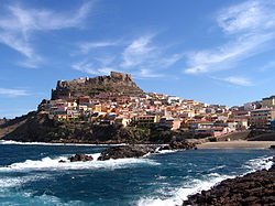
Castelsardo overlooks the center of the Gulf of Asinara, in the historical region of Anglona in the north of Sardinia, in a succession of rocky trachytic coasts with small inlets, with the exception of the beach of Lu Bagnu. Thanks to this position, the town, in addition to being exposed to the winds, enjoys a unique panorama spanning all the coasts of the gulf, including those of the Corsica.
The town is part of the most beautiful villages in Italy.
Background
The particular position, in addition to the existence of small natural landings, certainly contributed to the choice of the place as the site of ancient inhabited centers. The Romans already built their homes near the present tourist port. At that time the landing place was located on a named beach Fritum Janii (port of Giano) hence the current name of the port and the hill above, Frigiano. With the fall of the Roman Empire and the taking of power by the various judges, over the years many lands were donated to the Church and to various monastic orders. A few kilometers away the very important Benedictine monastery of Tergu, now in the archaeological study phase, while on the Frigiano hill there was already a monastery probably of Antonian hermits, around which the local population gathered. This center of aggregation lost its importance, to later become a hospital, when in 1102 the castle of the Genoese family of Doria was founded, baptized Castelgenovese, not to be confused with Castel Doria. This is considered the official date of foundation of the castle, but subsequent studies indicate 1270 as a much more probable date. The inhabitants of the area gradually moved inside the fortress which was impregnable until the advent of modern weapons. From 1520 the town was renamed Castillo Aragonés (Castel Aragonese); in the meantime it became a bishopric; construction of the cathedral began in 1586. In 1767 Castelsardo, under the Savoy dynasty, assumed its current name during the reign of Carlo Emanuele III, but unlike other royal cities, such as Alghero, Bosa, Cagliari, Oristano is Sassari, kept the Aragon bars of the past regime in its coat of arms, instead of replacing them with the Savoy cross. The city began to lose importance towards the first half of the nineteenth century, crushed by overly authoritarian landowners and by an impoverishment of cultural and social life, the only alternative to the few arable land, due to the progressive distancing of seminarians, friars, bishop. An adaptation of the infrastructures aimed at receiving attentive and cultured tourism is underway, as well as a relaunch of cultural initiatives.

How to orient yourself
How to get

By plane
By car
- From Olbia: Strada Statale 125 towards Palau-Arzachena. Once you arrive in Palau, continue towards Santa Teresa di Gallura and Castelsardo.
- From Porto Torres: Strada Statale 200. Once you reach the Lu Bagnu beach, continue towards Castelsardo.
- Port of Porto Torres
- Port of Olbia
On the train
The closest railway station is at Palau.
By bus
Bus from Olbia, from Golfo Aranci for Porto Torres arriving in Castelsardo.
How to get around
What see

- 1 Co-cathedral of Sant'Antonio abate. The church of Sant'Antonio became the seat of the bishopric of Ampurias in 1503. The current building derives from the renovations carried out between 1597 and the eighteenth century. The consecration of the temple took place in 1622. The building, which stylistically blends elements of Catalan Gothic and Renaissance classicism, is located in the historic center of Castelsardo, in a panoramic position overlooking the sea. Externally it is characterized above all by the high bell tower, covered by a majolica dome.

- 2 Elephant rock, Multeddu locality, at km 4.3 of the SS 134. The Elephant rock is a large trachytic and andesitic boulder, with a strong rust color, considerably eroded by atmospheric agents that have given it the singular appearance of a seated pachyderm. The rock, which has a height of about four meters. Originally the boulder was part of the rocky complex of Monte Castellazzu from which it detached by rolling downstream. In addition to a certain tourist-landscape importance, the Elephant rock also has a considerable archaeological importance for the two domus de janas, dating back to the pre-Nuragic period, which are housed inside. In 1914 the scholar Edoardo Benetti was the first to associate the original shape of the rock with an elephant, which until then was known, even in official documents, with the dialect name Sa Pedra Pertunta (the pierced stone).
Events and parties
What to do
Shopping
How to have fun
Where to eat
Where stay
Safety
How to keep in touch
Around
Other projects
 Wikipedia contains an entry concerning Castelsardo
 Commons contains images or other files on Castelsardo