| South Dakota | |
 | |
Location 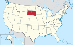 | |
Flag | |
| State | United States of America |
|---|---|
| Region | Great Plains |
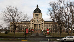
| Capital | Pierre |
| Surface | 199,905 km² |
| Inhabitants | 853.175 (2014 estimate), 814.180 (2010 census) |
| Tourism site | |
| Institutional website | |
South Dakota is a federated state of the United States of America.
To know
It is named after the Lakota (Sioux) Native American tribe.
Geographical notes
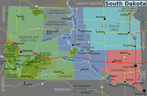
South Dakota is bordered to the north by the North Dakota, south col Nebraska, to the east with Iowa is Minnesota, west with Wyoming is Montana.
The Missouri River runs through central South Dakota. East of the river are low hills and glacial lakes. West of the river are deep canyons.
South Dakota is divided into four regions:
- Drift Prairie - It covers most of South East Dakota. It is the land of low hills and glacial lakes. This area was called Coteau des Prairies (Hills of the prairies) by the first settlers French. The Coteau des Prairies borders the Minnesota River Valley to the northeast and the James River Basin to the northwest. The James River Basin is mostly flat land.
- Dissected Till Plains - They are found in the southeastern part of South Dakota.
- Great Plains - It occupies more than two thirds of the western part of the state. The hills and valleys of the Coteau de Missouri lie between the James River Basin of the Drift Prairie and the Missouri River. West of the Missouri River, the terrain becomes more rugged and the landscape is more arid and features canyons, rolling hills and the characteristic butte (the rock formations that emerge from the ground with vertical slopes and clear limits, typical of western landscapes) up to 180 m. Proceeding south, east of the Black Hills is the most inhospitable region in the entire state, the famous Badlands of South Dakota.
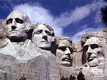
- Black Hills (Black Hills) - They are located in the southwestern part of South Dakota with mountains ranging in height from 600 to 1200m. South Dakota's tallest mountain, Harney Peak (2207m a.s.l.), is located in the Black Hills. The Homestake Mine, one of the largest gold mines in the US, is located in the Black Hills. The National Monument of Mount Rushmore it is obtained from a huge granite block outcropping in the Black Hills.
South Dakota's major rivers are the Cheyenne River, Missouri, James River, and White River. The major lakes are the Lake Oahe, the Lake Francis Homes and the Lake Lewis and Clark.
When to go
South Dakota has a continental climate with very cold winters and hot summers. During the summers the average maximum temperature is close to 32 ° C even if the night often drops to about 15 ° C. Winters are cold with maximum temperatures in January averaging below zero, and minimum temperatures averaging below -12 ° C.
Summer brings frequent thunderstorms. The eastern region of the state is part of the tornado area (the so-called tornado alley, an area of the United States where tornadoes are more frequent). Winters are a bit more stable. Strong winter storms, sometimes snow storms (blizzard), can occur in winter although snow usually falls in late autumn and early spring in South Dakota.
Background
Some finds document that the region was populated for at least 7,000 years. With the advent of the Europeans it was inhabited by populations organized in stable villages such as the Mandan. Explore in 1742-43 by cav. de la Vèrendrye who, as testimony, buried a lead plaque on 30 March 1743 on a hill in front of the city of Pierre, later found in 1913, followed the fate of Louisiana. It was little colonized until there were wars with the Sioux, especially after the discovery in the "Black Hills", sacred to the natives, of vast gold deposits. This is where the Wounded Knee massacre occurred in 1890. South Dakota was admitted to the Union on November 2, 1889 as the 40th state. On the same day the North Dakota. Previously, from March 2, 1861, it was established in the Dakota Territory.
Territories and tourist destinations
Urban centers
- Pierre - Capital of the Federated State of South Dakota, on the Missouri River.
- Aberdeen - Third largest city, located in the northeastern corner of the state. Headquarters of the Northern State University.
- Brookings - Home of South Dakota State University.
- Custer - The oldest city in the Black Hills.
- Deadwood - A national-historical landmark located in the Black Hills.
- Mitchell - Includes the Corn Palace, with new murals covering the exterior every year since 1892. Also includes the Mitchell Prehistoric Indian Village.
- Rapid City - The second largest city in the state, located at the base of the Black Hills along Interstate 90. Includes the Dinosaur Park, but also other attractions.
- Sioux Falls - The largest city in the state, named after the falls of the Big Sioux River.
- Wall - Access point for the Badlands and home of Wall Drug.
Other destinations
- Mount Rushmore
- Wind Cave National Park - so named for its sacred cave whose air is sucked in or blown out, depending on the weather.
- Badlands National Park
How to get
How to get around
What see
What to do
At the table
Safety
Other projects
 Wikipedia contains an entry concerning South Dakota
 Commons contains images or other files on South Dakota