
The Discovery tour Kassel is a 48 km long cycle path through the outer districts of kassel. The circuit connects numerous well-known and lesser-known sights, monuments, works of art and district projects with one another, but at the same time also several viewpoints with a view of the Kassel basin or the hilly one Surrounding area.
Route profile


- Length: 48 km
- Mark: The discovery tour Kassel is marked with a yellow lettering of the title on a blue background.
- Signposting: Either large individual signs or small separate signs under the bike signs. To be on the safe side, people who are unfamiliar with the area should always have an appropriate card with them.
- Slopes: Although the cycle route runs continuously in the Kassel Basin, there are some small and also large climbs, such as in the Langen Feld or the Jungfernkopf district, but these are limited and can usually be overcome quickly.
- Path condition: The discovery circuit Kassel runs 90% on asphalt paths and 10% on gravel paths, which is why the condition of the path can be described as very good.
- Traffic load: Residential streets with less traffic are predominantly used, but of course in a big city like kassel main roads can also be crossed or shared.
- Suitable bike: Touring bike with a 7-speed gear hub is sufficient, but three gears are sufficient if necessary.
- Family suitability: Yes, the Fuldabrücker Runde is also suitable for smaller children.
- Inline suitability: Only partially, as the Buga and Dorothea-Viehmann-Park, among other things, have to be bypassed.
background


kassel is the largest city of North Hesse and the third largest in Hesse. It is known nationwide above all for the Documenta that takes place every five years, the world's most important series of exhibitions for contemporary art, as well as the Bergpark Wilhelmshöhe with its water features, which became a UNESCO World Heritage Site in 2013. The discovery round Kassel was set up as a project for the 1100th anniversary of the city kassel, which should connect the city districts with each other.
getting there


There are many tram and bus stops along the Kassel discovery tour, so you can actually get on anywhere. Large information boards can be found at the junctions with the other long-distance cycle paths kassel: At the Bergpark Wilhelmshöhe, the Neue Mühle, the beach bar in the Buga, on Lindenberg, in Wolfsanger and on Kassel-Wilhelmshöhe train station. These provide information about the route, sights, restaurants and rest areas. Smaller information boards can be found at each station, mostly on street lamps that provide information about the respective sight.
Route description

The discovery circuit in Kassel runs largely on little-traveled residential streets, which are usually easily accessible with inline skaters. Even so, one shouldn't neglect that kassel has now become a small city, where cycling always requires more attention than in the country. But you pass a lot of stops where you can end your bike tour prematurely or just get on the bike route across the board. For a detailed cycling map, please simply click on the POIs that will immediately direct you to the described position.
Wahlershausen - New Mill (15 km)

Of the 1 Crossing Lange Straße / Kunoldstraße in the old town center of Wahlershausen, about which the Herkules-Wartburg cycle path you first drive up via Kunoldstraße to Wilhelmshöher Allee (short ascent). After crossing this at the ![]() Kunoldstrasse follow Kunoldstrasse straight ahead over Landgraf-Karl-Strasse at the
Kunoldstrasse follow Kunoldstrasse straight ahead over Landgraf-Karl-Strasse at the ![]() Walther-Schücking-Platz to the Wilhelmsgymnasium (cobblestone pavement), behind which you cycle via Bayernstraße and Lahnweg through the river district to Druseltalstraße. You can do this at the
Walther-Schücking-Platz to the Wilhelmsgymnasium (cobblestone pavement), behind which you cycle via Bayernstraße and Lahnweg through the river district to Druseltalstraße. You can do this at the ![]() Frankenstrasse Cross with the help of a set of traffic lights and continue on Frankenstrasse into the Marbachshöhe residential area. This soon turns into Marie-Calm-Straße, on which you drive downhill in an easterly direction and then turn south into a small gravel path at a curve. One comes on 2 Helleböhnweg find out which one to follow east at the
Frankenstrasse Cross with the help of a set of traffic lights and continue on Frankenstrasse into the Marbachshöhe residential area. This soon turns into Marie-Calm-Straße, on which you drive downhill in an easterly direction and then turn south into a small gravel path at a curve. One comes on 2 Helleböhnweg find out which one to follow east at the ![]() Helleböhnweg past and across Eugen-Richter-Strasse, before turning south into Helleböhnweg just before the railway. This runs fairly straight through the Süsterfeld / Helleböhn district (alternatively, you could also go directly to the Hessencourrier drive along the car-free street Am Rennsteig) and ends directly in front of the 3 Magazinhof With
Helleböhnweg past and across Eugen-Richter-Strasse, before turning south into Helleböhnweg just before the railway. This runs fairly straight through the Süsterfeld / Helleböhn district (alternatively, you could also go directly to the Hessencourrier drive along the car-free street Am Rennsteig) and ends directly in front of the 3 Magazinhof With ![]() Magazinhofthat will be bypassed once. Together with the Hessencourrierradweg you now cycle over several residential streets over Heinrich-Schütz-Allee to
Magazinhofthat will be bypassed once. Together with the Hessencourrierradweg you now cycle over several residential streets over Heinrich-Schütz-Allee to ![]() Korbacher Strasse / University at the edge of the dönche. You now follow the course of Korbacher Straße before you slowly reach Nordshausen via the streets Auf der Dönche, Eichenrodstraße and In den Steinen. Shortly afterwards you reach Korbacher Strasse again, behind which the one worth seeing 4 Nordshausen monastery church stands.
Korbacher Strasse / University at the edge of the dönche. You now follow the course of Korbacher Straße before you slowly reach Nordshausen via the streets Auf der Dönche, Eichenrodstraße and In den Steinen. Shortly afterwards you reach Korbacher Strasse again, behind which the one worth seeing 4 Nordshausen monastery church stands.

Near the route of the Hessencourriers, which one now crosses, also stands the ![]() Wallensteinstrasse, however, the discovery tour in Kassel follows the path Am Kirchgarten, which is south of the Brückenhof-Nordshausen elementary school and from Indoor swimming pool south runs along and in front of the sports fields to the south on Kronenackerstraße. You have now reached the Heisebach wetland biotope, which you leave to the right and continue cycling on a gravel path along the Heisebach until you come to Mattenbergstraße. Shortly afterwards, the tram tracks are crossed and you have reached the old town center of Oberzwehren. At the Thomaskirche with the same name
Wallensteinstrasse, however, the discovery tour in Kassel follows the path Am Kirchgarten, which is south of the Brückenhof-Nordshausen elementary school and from Indoor swimming pool south runs along and in front of the sports fields to the south on Kronenackerstraße. You have now reached the Heisebach wetland biotope, which you leave to the right and continue cycling on a gravel path along the Heisebach until you come to Mattenbergstraße. Shortly afterwards, the tram tracks are crossed and you have reached the old town center of Oberzwehren. At the Thomaskirche with the same name ![]() Thomas Church you pass in front of the Kassel-Oberzwehren train station (RT5 and RT9) into Altenbaunaer Straße and reaches the under the railway bridge of the Main-Weser-Bahn
Thomas Church you pass in front of the Kassel-Oberzwehren train station (RT5 and RT9) into Altenbaunaer Straße and reaches the under the railway bridge of the Main-Weser-Bahn ![]() Keilsbergstrasse. Follow Altenbaunaer Straße a short distance before turning south into Dorothea-Viehmann-Park and crossing it once along the Goldbach on a gravel path. At the end of the park you stand the
Keilsbergstrasse. Follow Altenbaunaer Straße a short distance before turning south into Dorothea-Viehmann-Park and crossing it once along the Goldbach on a gravel path. At the end of the park you stand the ![]() At the Goldbach, on which you cycle further northwest along the federal highway 49 on an asphalt farm road back to the Main-Weser-Bahn. After a short ascent, you cross under the motorway and drive on the street Am Keilsberg along Eselsgraben. Finally, turn south and cycle up to the Lange Feld and branch off again to the east on the next paved path. The Niederzwehren Cemetry and the Russian Cemetery are also nearby, but you cycle north of the planned industrial area across the 5 Waiting stick. Behind this you drive downhill again to the Kassel power plant and right in front of it at a fence. You finally reach the Neue Mühle via the street Am Sandgraben
At the Goldbach, on which you cycle further northwest along the federal highway 49 on an asphalt farm road back to the Main-Weser-Bahn. After a short ascent, you cross under the motorway and drive on the street Am Keilsberg along Eselsgraben. Finally, turn south and cycle up to the Lange Feld and branch off again to the east on the next paved path. The Niederzwehren Cemetry and the Russian Cemetery are also nearby, but you cycle north of the planned industrial area across the 5 Waiting stick. Behind this you drive downhill again to the Kassel power plant and right in front of it at a fence. You finally reach the Neue Mühle via the street Am Sandgraben ![]() New mill and the Hess. Long-distance cycle route R1 (Fulda cycle route).
New mill and the Hess. Long-distance cycle route R1 (Fulda cycle route).
New mill - harbor bridge (15 km)
Follow this from the Neue Mühle Hess. Long-distance cycle route R1 (Fulda cycle route), which initially runs briefly uphill to the bridge over the Fulda, then downhill again on the other side and through the Fuldaaue to Kasseler Straße. Follow this to the north and soon cycle on a paved separate foot and cycle path right next to federal highway 83, before turning left into a gravel path just before federal highway 49. This first leads below the motorway before it crosses it and you come out at the parking lot of the Kassel exhibition center. Now you drive under the 6 Railway bridge through to then on Damaschkestrasse on ![]() Exhibition halls drive past into the Buga. In this one drives on gravel paths past the beach bar, then branches off from Hess. Long-distance cycle route R1 (Fulda cycle route) from and over several bridges you reach the sailing restaurant, from which you can take a small gravel path north of the
Exhibition halls drive past into the Buga. In this one drives on gravel paths past the beach bar, then branches off from Hess. Long-distance cycle route R1 (Fulda cycle route) from and over several bridges you reach the sailing restaurant, from which you can take a small gravel path north of the ![]() Fulda lakes cycle uphill and cross the federal highway 83 over a bridge. You are now in Kasseler Waldau district and turns behind the tithe barn
Fulda lakes cycle uphill and cross the federal highway 83 over a bridge. You are now in Kasseler Waldau district and turns behind the tithe barn ![]() Tithe barn turn right into Nürnberger Straße. Follow this and then continue along Kasseler Strasse before turning left at the old school into Waldemar-Petersen-Strasse. Behind the
Tithe barn turn right into Nürnberger Straße. Follow this and then continue along Kasseler Strasse before turning left at the old school into Waldemar-Petersen-Strasse. Behind the ![]() Community center and the fire brigade, you turn east again and cycle on a gravel path through the gardens to Stegerwaldstrasse, where you turn left and pass the Waldau Open School and come to the Wahlebach. After crossing the former railway line, turn right on 7 Wahlebach along before getting along with the Herkules-Wartburg cycle path drives on the Lindenbergstraße past a sports field into the district of Forstfeld.
Community center and the fire brigade, you turn east again and cycle on a gravel path through the gardens to Stegerwaldstrasse, where you turn left and pass the Waldau Open School and come to the Wahlebach. After crossing the former railway line, turn right on 7 Wahlebach along before getting along with the Herkules-Wartburg cycle path drives on the Lindenbergstraße past a sports field into the district of Forstfeld.

After crossing several streets, including Ochshäuser Straße ![]() Windhoek Street, turn right at the end of Payerstraße into Steinigkstraße and shortly afterwards left into Windhukstraße. Before the bend, the Kassel discovery tour leads a short distance on the now graveled former railway line of the Söhrebahn before turning left into Forstbachweg at an Edeka market. At the
Windhoek Street, turn right at the end of Payerstraße into Steinigkstraße and shortly afterwards left into Windhukstraße. Before the bend, the Kassel discovery tour leads a short distance on the now graveled former railway line of the Söhrebahn before turning left into Forstbachweg at an Edeka market. At the ![]() Ahornweg past you finally reach the downhill
Ahornweg past you finally reach the downhill ![]() Lindenberg, at which one crosses Leipziger Strasse via traffic lights and branches off into Fischhausweg. You then follow this to the Losse, which you then drive along towards the west. In front of the Cornelius-Gellert-Kampfbahn then to the right and at the edge of the oak forest again to the left over the Eichwaldstraße to 8 Jewish Cemetery. Via the Eichwaldstraße and the Olebachweg you reach the Joseph-von-Eichendorff-Schule, in front of which you can walk along the Eichwaldstraße along the paved Vogelsang path on an old railway wagon
Lindenberg, at which one crosses Leipziger Strasse via traffic lights and branches off into Fischhausweg. You then follow this to the Losse, which you then drive along towards the west. In front of the Cornelius-Gellert-Kampfbahn then to the right and at the edge of the oak forest again to the left over the Eichwaldstraße to 8 Jewish Cemetery. Via the Eichwaldstraße and the Olebachweg you reach the Joseph-von-Eichendorff-Schule, in front of which you can walk along the Eichwaldstraße along the paved Vogelsang path on an old railway wagon ![]() Vogelsang reached. After crossing the Losse, cycle along it on Burgstraße and Inselweg, before crossing the Losse again at the village square of Bettenhausen and continuing along the Buttlarstraße and the Lossestraße, which has two asphalt strips. When you arrive at Sandershäuser Strasse, take the
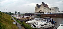
Vogelsang reached. After crossing the Losse, cycle along it on Burgstraße and Inselweg, before crossing the Losse again at the village square of Bettenhausen and continuing along the Buttlarstraße and the Lossestraße, which has two asphalt strips. When you arrive at Sandershäuser Strasse, take the ![]() At the Sälzerhof past to Dresdener Straße, which you cross with traffic lights and turn into Spangenberger Straße on the other side of the street. At the end of this turn right into Ellenbacher Strasse and at several 9 SMA buildings over towards the Loss delta. Passing south of this one then reaches the Kasseler Hafen and cycle on the Hafenstrasse to the two
At the Sälzerhof past to Dresdener Straße, which you cross with traffic lights and turn into Spangenberger Straße on the other side of the street. At the end of this turn right into Ellenbacher Strasse and at several 9 SMA buildings over towards the Loss delta. Passing south of this one then reaches the Kasseler Hafen and cycle on the Hafenstrasse to the two ![]() port and Harbor bridge over to 10 Harbor bridge. From the harbor bridge, it is the shortest from the discovery tour of Kassel to the city center of kassel.
port and Harbor bridge over to 10 Harbor bridge. From the harbor bridge, it is the shortest from the discovery tour of Kassel to the city center of kassel.
Harbor Bridge - Wahlershausen (18 km)


The harbor bridge will be used together with the Hess. Long-distance cycle route R1 (Fulda cycle route) leave in a northerly direction before turning east into Bleichenweg at the end. You then follow this to its end and continue on an asphalt footpath and bike path not far from the Fulda in an arc past the sewage treatment plant. Behind this then straight through the meadows until you turn left and right again shortly before Fuldatalstraße. Between the ![]() Wolfsanger and along the Fulda, the discovery tour of Kassel finally branches off at the end of the village kassel from Hess. Long-distance cycle route R1 (Fulda cycle route) in the 11 Metzelsteinstrasse from. Follow this steeply uphill for a short while, then slowly ascending to the Triftweg, in which you turn right and leave a little later via the Kinderwiesenweg. Then you cycle for a short time on the Grenzweg before you turn west onto an asphalt farm road, from which you have a beautiful view. You reach the Höheweg, drive a short bit south on it, before you walk past the north cemetery on the Lindenweg 12 Ihringshäuser Strasse With
Wolfsanger and along the Fulda, the discovery tour of Kassel finally branches off at the end of the village kassel from Hess. Long-distance cycle route R1 (Fulda cycle route) in the 11 Metzelsteinstrasse from. Follow this steeply uphill for a short while, then slowly ascending to the Triftweg, in which you turn right and leave a little later via the Kinderwiesenweg. Then you cycle for a short time on the Grenzweg before you turn west onto an asphalt farm road, from which you have a beautiful view. You reach the Höheweg, drive a short bit south on it, before you walk past the north cemetery on the Lindenweg 12 Ihringshäuser Strasse With ![]() Ihringshäuser Strasse comes. The Ihringshäuser Straße can be passed with the help of a set of traffic lights, then the discovery tour of Kassel continues over the Wielandstraße and the Simmershäuser Straße to the allotment gardens. These are bypassed on asphalt roads to the north and south of the pasture park along the Kasseler Philippinenhof-Warteberg district. Past the St. Laurentius church, roll downhill over Weidestrasse to the Zionskirche and meet behind the Aldi market and the
Ihringshäuser Strasse comes. The Ihringshäuser Straße can be passed with the help of a set of traffic lights, then the discovery tour of Kassel continues over the Wielandstraße and the Simmershäuser Straße to the allotment gardens. These are bypassed on asphalt roads to the north and south of the pasture park along the Kasseler Philippinenhof-Warteberg district. Past the St. Laurentius church, roll downhill over Weidestrasse to the Zionskirche and meet behind the Aldi market and the ![]() Hegelsberg School on the two bike paths Kassel-Edersee cycle path and Reinhardswald cycle path. You then follow these north along the Ahna, before you leave the route again and along the Bunsenstraße 13 Dutch street With
Hegelsberg School on the two bike paths Kassel-Edersee cycle path and Reinhardswald cycle path. You then follow these north along the Ahna, before you leave the route again and along the Bunsenstraße 13 Dutch street With ![]() Dutch street reached.
Dutch street reached.

After successfully crossing the Holländische Straße, you get to the Schenkebier Stanne under the railway bridges of the marshalling yard ![]() By the willow trees pass until you get to the railroad track kassel-Warburg with the train station kassel- Jungfernkopf reached and below this at the
By the willow trees pass until you get to the railroad track kassel-Warburg with the train station kassel- Jungfernkopf reached and below this at the ![]() Maiden head drives past through it. The discovery tour Kassel now follows the Waldecker Straße at the Jungfernkopf church
Maiden head drives past through it. The discovery tour Kassel now follows the Waldecker Straße at the Jungfernkopf church ![]() To the camp past and continue briefly over a gravel path on the road Am Ziegenberg, before turning south on the hill into the Kornblumenweg. After attending the
To the camp past and continue briefly over a gravel path on the road Am Ziegenberg, before turning south on the hill into the Kornblumenweg. After attending the ![]() Cornflower path has cycled past, turn right at the end of the street and now follow Wegmannstraße on 14 Harleshausen cemetery past to Obervellmarer Straße. Cross it over a bridge and reach the Gladiolenweg, branch off to the south onto the Orchideenweg and then onto the first paved path to the east. On this one rolls partly steeply downhill to Firnskuppenstrasse, which one crosses and passes the Geilebach via Daspelstrasse. After turning into the street Im Baumhof you finally reach that Harleshausen outdoor pool with the same name
Cornflower path has cycled past, turn right at the end of the street and now follow Wegmannstraße on 14 Harleshausen cemetery past to Obervellmarer Straße. Cross it over a bridge and reach the Gladiolenweg, branch off to the south onto the Orchideenweg and then onto the first paved path to the east. On this one rolls partly steeply downhill to Firnskuppenstrasse, which one crosses and passes the Geilebach via Daspelstrasse. After turning into the street Im Baumhof you finally reach that Harleshausen outdoor pool with the same name ![]() Harleshausen outdoor pool. You can reach the via the streets Am Hilgenberg, Falkenweg and Eschebergstraße
Harleshausen outdoor pool. You can reach the via the streets Am Hilgenberg, Falkenweg and Eschebergstraße ![]() Sperberweg, before which you turn south into the Sperberweg and follow it straight ahead. Behind a free area this becomes Lerchenfeldstraße and you cycle on like this
Sperberweg, before which you turn south into the Sperberweg and follow it straight ahead. Behind a free area this becomes Lerchenfeldstraße and you cycle on like this ![]() Lerchenfeldstrasse passing over paved roads and paths always straight over the 15 Lerchenfeldstrasse Roe deer meadows and along the edge of the forest on a gravel path downhill. Below you meet the Wilhelmshöher Weg, which you now paved uphill again to
Lerchenfeldstrasse passing over paved roads and paths always straight over the 15 Lerchenfeldstrasse Roe deer meadows and along the edge of the forest on a gravel path downhill. Below you meet the Wilhelmshöher Weg, which you now paved uphill again to ![]() Prince Spring follows. At this, the discovery tour of Kassel turns to the east and runs over Schanzenstraße to
Prince Spring follows. At this, the discovery tour of Kassel turns to the east and runs over Schanzenstraße to ![]() Stahlbergstrasse, before which it branches off sharply to the right into Ochsenallee. You then follow this to the Prinzenquelle with a beautiful water treading facility, where you turn off the edge of the forest and continue along the asphalted ox avenue through the fields and pastures to just before the large parking lot below the Bergpark Wilhelmshöhe follows. At the information board, turn left and follow the asphalt farm road to the tram tracks, where you turn left again and cycle above the KVG depot Wilhelmshöhe. Behind this then on the Rammelsbergstraße past the reform school downhill over the Drusel and continue on the cobblestone Langen Straße until you are back in the old town center of Wahlershausen.
Stahlbergstrasse, before which it branches off sharply to the right into Ochsenallee. You then follow this to the Prinzenquelle with a beautiful water treading facility, where you turn off the edge of the forest and continue along the asphalted ox avenue through the fields and pastures to just before the large parking lot below the Bergpark Wilhelmshöhe follows. At the information board, turn left and follow the asphalt farm road to the tram tracks, where you turn left again and cycle above the KVG depot Wilhelmshöhe. Behind this then on the Rammelsbergstraße past the reform school downhill over the Drusel and continue on the cobblestone Langen Straße until you are back in the old town center of Wahlershausen.
literature
- Bicycle city map of Kassel - Scale 1:20 000 with street directory, € 4.50, published by the Surveying and Geoinformation Office of the City of Kassel (5th edition, 2011)
- Regional cycle route map Kassel - city and surrounding area - Scale 1:30 000 with contour lines, € 4.50, published by the Surveying and Geoinformation Office of the City of Kassel (5th edition, 2011)
- Flyer of the discovery tour Kassel - The flyer was published by the City of Kassel and is available at the Kassel Marketing Tourist Information Center on Wilhelmsstraße and at Wilhelmshöhe station. It contains a brief description of all the stations and sights along the route, as well as a small route map with an elevation profile.