
The Kassel-Edersee cycle path is a 72 km long cycle path from kassel through the Habichtswald Nature Park above Wolfhagen to the Edersee. Although the name suggests a direct connection between the two places, which is only 34 km as the crow flies, the very scenic cycle route does not run over this but over several detours.
Route profile


- Length: 72 km
- Mark: The Kassel-Edersee-Radweg is marked with a green cyclist on a white background, which symbolically shows the gradients of the Habichtswaldes drives up.
- Signposting: Small separate signs, between kassel and Habichtswald under the bike signs, between Habichtswald and the Edersee attached individually. To be on the safe side, people who are unfamiliar with the area should always have an appropriate card with them.
- Slopes: There are three passes with some steeper climbs to conquer, east of the Hohen Dörnbergs, in the north of Zierenberg-Burghasungen and at Waldeck-Frankenhagen.
- Path condition: Most of the Kassel-Edersee-Radweg runs on asphalt paths, only occasionally on gravel paths, where thicker tires are sometimes advantageous, but not mandatory.
- Traffic load: Little, there between Bodenhausen and Wolfhagen state roads and district roads are also used, some of which are heavily, but sometimes only rarely used by cars.
- Suitable bike: Touring bike with a 7-speed gear hub is sufficient, but more gears are better.
- Family suitability: No, because the Kassel-Edersee-Radweg is not the most direct route between kassel and the Edersee runs and has a very pronounced elevation profile. Only sections are also suitable for smaller children.
- Inline suitability: No. Just the section between kassel and Ahnatal-Weimar is passable with inline skates.
background

kassel is the largest city of North Hesse and the third largest in Hesse. It is known nationwide above all for the Documenta that takes place every five years, the world's most important series of exhibitions for contemporary art, and the Wilhelmshöhe Mountain Park with its water features, which became a UNESCO World Heritage Site in 2013.
The Edersee in the Waldecker Land is the second largest reservoir in terms of area and third largest in terms of volume Germany. Its 48 m high dam was built between 1908 and 1914, and has been bordering it since 2004 Kellerwald-Edersee National Park in the south to the Edersee.
getting there

With public transport

At the Kassel main station stop numerous regional trains and RegioTrams, as well as city and regional buses of the KVG and the NVV. To Wolfhagen runs the railway line Vellmar-Volkmarsen roughly along the route of the Kassel-Edersee-Radweg and is through the Regional train line 4 the Kurhessenbahn, partly served with a converted bicycle cart. To the Edersee the two bus routes operate 510 and 515, often with bike racks or bike trailers (see timetable).
By bicycle


The starting point of the Kassel-Edersee cycle path on Kassel main station is about the Herkules-Wartburg cycle path and to reach local bike routes. At Wolfhagen the cycle path is partly identical to the Hess. Long-distance cycle route R4, am Edersee there is a link with the Eder cycle path, the Hess. Long-distance cycle route R5 and the Hess. Long-distance cycle route R6.
Route description


The Kassel-Edersee-Radweg is not the most direct route between kassel and the Edersee, but has some dangles in its route. If you want to get ahead faster, you should look for shorter ways, for example via the Hoofer gate or Naumburg. If you just want to enjoy the landscape, the Kassel-Edersee cycle path is the right place for you. For a detailed cycling map, please simply click on the POIs that will immediately direct you to the described position.
Kassel - Weimar (15 km)


The start of the Kassel-Edersee cycle path is on the 1 Rainer-Dierichs-Platz, the forecourt of the Kassel main station With ![]() Central Station, from which one drives on Kurfürstenstrasse to Scheidemannplatz. At the eponymous
Central Station, from which one drives on Kurfürstenstrasse to Scheidemannplatz. At the eponymous ![]() Scheidemannplatz The cycle route is divided into two variants: While you are from Kassel Central Station coming now diagonally right through a house passage under the Chamber of Commerce and across Theaterstrasse and Wolfsschlucht to
Scheidemannplatz The cycle route is divided into two variants: While you are from Kassel Central Station coming now diagonally right through a house passage under the Chamber of Commerce and across Theaterstrasse and Wolfsschlucht to ![]() Königsplatz / Mauerstrasse If you drive, you cycle in the opposite direction via Kölnische Straße, a one-way street, to Scheidemannplatz. From the back of the CityPoints then past the former location of Stadtbad Mittes, continue on Mauerstraße over Kurt-Schuhmacher-Straße until just before Wolfhager Straße (Bundesstraße 251), where you turn right into a footpath and bike path. You can come along at Holländischer Platz
Königsplatz / Mauerstrasse If you drive, you cycle in the opposite direction via Kölnische Straße, a one-way street, to Scheidemannplatz. From the back of the CityPoints then past the former location of Stadtbad Mittes, continue on Mauerstraße over Kurt-Schuhmacher-Straße until just before Wolfhager Straße (Bundesstraße 251), where you turn right into a footpath and bike path. You can come along at Holländischer Platz ![]() Dutch place find out which one crosses either through the underpasses or the traffic lights and then onto Henschelstrasse at the university kassel to cycle past. Via Gottschalkstraße past the former Gottschalk site you get to the Slaughterhouse cultural center at the 2 Nordstadtpark. From this one now drives together with the Reinhardswald cycle path always along the Ahna, partly via Fiedlerstraße, partly on paved footpaths and bike paths until you get back on the 3 Bunsenstrasse comes. Here you turn right and drive on a bike path along the Niedervellmarer Straße past the
Dutch place find out which one crosses either through the underpasses or the traffic lights and then onto Henschelstrasse at the university kassel to cycle past. Via Gottschalkstraße past the former Gottschalk site you get to the Slaughterhouse cultural center at the 2 Nordstadtpark. From this one now drives together with the Reinhardswald cycle path always along the Ahna, partly via Fiedlerstraße, partly on paved footpaths and bike paths until you get back on the 3 Bunsenstrasse comes. Here you turn right and drive on a bike path along the Niedervellmarer Straße past the ![]() Rohrwiesenstrasse (Line 44) to Vellmar into it. Shortly after the entrance to Niedervellmar, the Kassel-Edersee-Radweg branches off to the right into Wiesenstraße and leads on an asphalt farm road through the fields to the railway line. This is crossed under with the Ahna and you cycle along the Ihringshäuser Straße 4 Niedervellmar into it.
Rohrwiesenstrasse (Line 44) to Vellmar into it. Shortly after the entrance to Niedervellmar, the Kassel-Edersee-Radweg branches off to the right into Wiesenstraße and leads on an asphalt farm road through the fields to the railway line. This is crossed under with the Ahna and you cycle along the Ihringshäuser Straße 4 Niedervellmar into it.
From now on to the Ahnepark only on tarred footpaths and bike paths along the Ahna; in between you pass a few playgrounds and cross under Kasseler Straße until you reach the ![]() Fairground (line 1), at which the Brüder-Grimm-Strasse is crossed or under. Shortly afterwards you cross under the developed federal highway 7/83 and come to the Ahnepark. Past the old mill and the Ahnepark restaurant, as well as several 5 You cycle through ponds and a playground and at the small one Steam train out of this again. Shortly afterwards the branch also branches off Reinhardswald cycle path and you drive through the old town center of Obervellmar over the Alte Hauptstraße and the street Am Mühlenberg past the cemetery to the railway line kassel - Warburg. This is underpassed in an underpass together with the ancestor and you continue on a tarred farm road to a tree nursery. From this then on or along the main road 6 Heckershausen in and past the
Fairground (line 1), at which the Brüder-Grimm-Strasse is crossed or under. Shortly afterwards you cross under the developed federal highway 7/83 and come to the Ahnepark. Past the old mill and the Ahnepark restaurant, as well as several 5 You cycle through ponds and a playground and at the small one Steam train out of this again. Shortly afterwards the branch also branches off Reinhardswald cycle path and you drive through the old town center of Obervellmar over the Alte Hauptstraße and the street Am Mühlenberg past the cemetery to the railway line kassel - Warburg. This is underpassed in an underpass together with the ancestor and you continue on a tarred farm road to a tree nursery. From this then on or along the main road 6 Heckershausen in and past the ![]() Cassel width, center and Gehrenweg (Lines 48 and 49). After crossing Heckershausen, continue cycling from the roundabout and the voluntary fire brigade on a separate footpath and bike path together with the Ahnetalweg (V) along Heckershäuser Straße to the entrance to Weimar, which is also closed Ahnatal belongs. At two supermarkets, a gas station, the
Cassel width, center and Gehrenweg (Lines 48 and 49). After crossing Heckershausen, continue cycling from the roundabout and the voluntary fire brigade on a separate footpath and bike path together with the Ahnetalweg (V) along Heckershäuser Straße to the entrance to Weimar, which is also closed Ahnatal belongs. At two supermarkets, a gas station, the ![]() shopping mall (Lines 48 and 49) and past the cemetery you continue on Heckershäuser Straße into the village and finally come to 7 Ahnatal-Weimar train station with the same name
shopping mall (Lines 48 and 49) and past the cemetery you continue on Heckershäuser Straße into the village and finally come to 7 Ahnatal-Weimar train station with the same name ![]() railway station (Lines 48 and 49), of which the Kurhessenbahn wrong (KBS 612). If you want, you can make a short detour to the Bühl natural bathing lake, which is located south of the train station and is well signposted.
railway station (Lines 48 and 49), of which the Kurhessenbahn wrong (KBS 612). If you want, you can make a short detour to the Bühl natural bathing lake, which is located south of the train station and is well signposted.
Weimar - Wolfhagen (21 km)


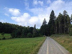
You cycle under the railway line on Dörnbergstraße to ![]() Böllhöfe (Line 49) at which you turn slightly to the right and follow Triftstraße to a soccer field, before which you turn right again into Mühlwiesenweg. At the end to the left and now only on an asphalt farm road, then on a gravel road (partly in poor condition) to the edge of the forest. The approx. 1 km long ascent up the forest to below the begins here Hohen Dörnbergs, The signposts of the hiking trail ⊥ and des provide orientation in between Kassel-Steigs. Are you at the top of one 8 Arrived at the small intersection of different paths, you can take a detour to the Helfensteinen make (see picture). To do this, just follow the meadow path straight ahead, but this is only accessible with mountain bikes. Cyclists with normal bicycles (thinner bicycle tires) are best attached to the bicycle signpost here. It then continues on a coarser gravel road on the eastern slope of the Hohen Dörnbergs along which is only passable in dry conditions. West of the Hohlesteins you step out of this again and drive gently downhill on a tarred path in a zigzag. Finally, the Kassel-Edersee cycle path turns imperceptibly to the right (watch out, small signpost) and runs along the edge of the forest on the road Vor dem Berge nach Habichtswald-Dörnberg into it. At the end of this street, turn left on Zierenberger Straße, before turning right again shortly afterwards into Breiten Weg and at the 9 Fire brigade (in front of it information board 43.3 km) with
Böllhöfe (Line 49) at which you turn slightly to the right and follow Triftstraße to a soccer field, before which you turn right again into Mühlwiesenweg. At the end to the left and now only on an asphalt farm road, then on a gravel road (partly in poor condition) to the edge of the forest. The approx. 1 km long ascent up the forest to below the begins here Hohen Dörnbergs, The signposts of the hiking trail ⊥ and des provide orientation in between Kassel-Steigs. Are you at the top of one 8 Arrived at the small intersection of different paths, you can take a detour to the Helfensteinen make (see picture). To do this, just follow the meadow path straight ahead, but this is only accessible with mountain bikes. Cyclists with normal bicycles (thinner bicycle tires) are best attached to the bicycle signpost here. It then continues on a coarser gravel road on the eastern slope of the Hohen Dörnbergs along which is only passable in dry conditions. West of the Hohlesteins you step out of this again and drive gently downhill on a tarred path in a zigzag. Finally, the Kassel-Edersee cycle path turns imperceptibly to the right (watch out, small signpost) and runs along the edge of the forest on the road Vor dem Berge nach Habichtswald-Dörnberg into it. At the end of this street, turn left on Zierenberger Straße, before turning right again shortly afterwards into Breiten Weg and at the 9 Fire brigade (in front of it information board 43.3 km) with ![]() town hall (Lines 22 and 117) and finally passes the town hall. Continue along with the Eco path cultural history Habichtswald Pass on the Breite Weg north of the cemetery until you turn left into the crossroads (no signposts). When you arrive at the federal road 251, turn right (twisted signpost) and take a separate path along this, later also on the old route of the federal road past the
town hall (Lines 22 and 117) and finally passes the town hall. Continue along with the Eco path cultural history Habichtswald Pass on the Breite Weg north of the cemetery until you turn left into the crossroads (no signposts). When you arrive at the federal road 251, turn right (twisted signpost) and take a separate path along this, later also on the old route of the federal road past the ![]() Basically (Lines 22, 110 and 117). Finally, between a supermarket and a petrol station, you reach Ehlen, also a district of Habichtswald and turns behind the 10
Basically (Lines 22, 110 and 117). Finally, between a supermarket and a petrol station, you reach Ehlen, also a district of Habichtswald and turns behind the 10 ![]() gardenstreet (Lines 22, 110 and 117) turn right into Finkenweg.
gardenstreet (Lines 22, 110 and 117) turn right into Finkenweg.
From now on you drive a short distance with the Warmetalweg on a paved path downhill, crossed the warmer with the help of a bridge and finally comes to the state road 3390. During the Warmetalweg Turn right here and follow a beautiful asphalt farm road through the Warmetal Zierenberg leads, the Kassel-Edersee-Radweg turns left and follows the main road to a crossroads. The Hess comes here from the north. Long-distance cycle path R4, with which you can now continue cycling on the state road 3390 under the federal motorway 44 to the top of the pass north of Burghasungen. Once at the top you can go on 11 Wanderparkplatz Sollberg take a breather before you go downhill to just before Wenigenhasungen, a district of Wolfhagen. Here the Kassel-Edersee-Radweg turns left into the street Trinkeweech and first passes the town to the east before crossing the Erpe and cycling along the Lange Straße into it. In the center of the village you turn in front of the ![]() Erpetalstrasse (Lines 111 and 117) into Hasunger Straße, where you will find a sign for the Kassel-Edersee cycle path and, at the same time, the Hess. Long-distance cycle path R4 branches off from the Kassel-Edersee cycle path. Both meet behind Wolfhagen together again. (Note: Although all maps are shown via Philippinenthal, the Kassel-Edersee-Radweg runs via Altenhasungen. This was checked on site by the author in June 2014.)
Erpetalstrasse (Lines 111 and 117) into Hasunger Straße, where you will find a sign for the Kassel-Edersee cycle path and, at the same time, the Hess. Long-distance cycle path R4 branches off from the Kassel-Edersee cycle path. Both meet behind Wolfhagen together again. (Note: Although all maps are shown via Philippinenthal, the Kassel-Edersee-Radweg runs via Altenhasungen. This was checked on site by the author in June 2014.)
Now we continue on Hasunger Straße, which is in poor condition but is not very busy, through the Erpe Valley to Altenhasungen, the center of which can be reached via Heerstraße and Bärenbergstraße. At the 12 At the crossroads you will find the signs to the nearby train station (RT4), which can be reached uphill via Hardstraße past two stops, but the cycle path turns into Unter den Linden and runs again over the Erpe from the district of Wolfhagen out. At the end of the village you can take a short detour to the Festberg nature reserve near Philippinenthal make, a small but very beautiful vantage point on a hill overgrown with limestone grass. It continues now together with the student path (X 13) and the Huguenot and Waldensian path on an easily navigable asphalt farm road past small trees through the Erpe valley south of the lawn mill to the rifle house. After the junction to Philippinenthal, you cycle over a bridge, from which the Kassel-Edersee cycle path in two arcs under the railway line Obervellmar-Volkmarsen and south of the Schützeberg with a good view past the Neue Mühle to the Oleimühle, where the eponymous mill is located ![]() Olei mill (Line 140) is located. From Oleimühle you drive along the busy state road 3214 (Schützeberger Straße) past several yards and old mills Wolfhagen; alternatively, you can also use the little traffic circle road 94 via Elmarshausen, which is also connected with a small, minimal detour. The latter variant is as Eco path cultural history Wolfhagen signposted and meets at the entrance of Wolfhagen before the railway line is back on the Kassel-Edersee cycle path. The train station of Wolfhagen can be reached after crossing under the railway line and when you get to the 13
Olei mill (Line 140) is located. From Oleimühle you drive along the busy state road 3214 (Schützeberger Straße) past several yards and old mills Wolfhagen; alternatively, you can also use the little traffic circle road 94 via Elmarshausen, which is also connected with a small, minimal detour. The latter variant is as Eco path cultural history Wolfhagen signposted and meets at the entrance of Wolfhagen before the railway line is back on the Kassel-Edersee cycle path. The train station of Wolfhagen can be reached after crossing under the railway line and when you get to the 13 ![]() Branch train station to the left the Bahnhofstrasse to railway station cycle up, where you will also find an information board for the Kassel-Edersee cycle path. They run at the train station RT4 and R4, as well as numerous city, school and intercity bus routes. AST traffic was discontinued in December 2013 and replaced by the new city bus.
Branch train station to the left the Bahnhofstrasse to railway station cycle up, where you will also find an information board for the Kassel-Edersee cycle path. They run at the train station RT4 and R4, as well as numerous city, school and intercity bus routes. AST traffic was discontinued in December 2013 and replaced by the new city bus.
Wolfhagen - Freienhagen (16 km)


Of the ![]() Junction to the train station follow the Schützeberger Straße (L 3214) over the federal highway 450 and past the
Junction to the train station follow the Schützeberger Straße (L 3214) over the federal highway 450 and past the ![]() Old dairy in the old town center of Wolfhagen into it, which you reach after a small incline. In the further course of the route, Schützeberger Straße is then partially a one-way street, but open to cyclists in both directions. This is how you cycle on the
Old dairy in the old town center of Wolfhagen into it, which you reach after a small incline. In the further course of the route, Schützeberger Straße is then partially a one-way street, but open to cyclists in both directions. This is how you cycle on the ![]() court House (Line 112) past, behind which you leave the old town center and downhill to just before the
court House (Line 112) past, behind which you leave the old town center and downhill to just before the ![]() Hans-Staden-Strasse (Line 110) where you turn left into a smaller paved road (shortly after this turn the path forks, keep left) which you go through the fields to the Hess. Long-distance cycle route R4 follows. From now on, you can ride along this very well signposted long-distance cycle path to the farms on 14 Regelweg, on the sand side past gravel farm roads, always along the Ofenstein water until you come to several small ponds. Behind these you keep to the west, climb a small incline and see the small town in front of you Wolfhagen-Leckringhausen, in which the
Hans-Staden-Strasse (Line 110) where you turn left into a smaller paved road (shortly after this turn the path forks, keep left) which you go through the fields to the Hess. Long-distance cycle route R4 follows. From now on, you can ride along this very well signposted long-distance cycle path to the farms on 14 Regelweg, on the sand side past gravel farm roads, always along the Ofenstein water until you come to several small ponds. Behind these you keep to the west, climb a small incline and see the small town in front of you Wolfhagen-Leckringhausen, in which the ![]() Leckringhausen (Line 110) is located. From the hill back to the small valley of the Ofensteinwasser and on a gravel farm road straight west along the state road 3214. After cycling closer and closer to Ippinghausen, they split up shortly before this place 15 the Kassel-Edersee-Radweg (right) and the Hess. Long-distance cycle path R4 (straight ahead) (to Naumburg and Fritzlar) from each other (signpost was missing in September 2015). The Kassel-Edersee-Radweg initially leads north along Ippinghausen, before it meets the Leckringhäuser Straße and this at the
Leckringhausen (Line 110) is located. From the hill back to the small valley of the Ofensteinwasser and on a gravel farm road straight west along the state road 3214. After cycling closer and closer to Ippinghausen, they split up shortly before this place 15 the Kassel-Edersee-Radweg (right) and the Hess. Long-distance cycle path R4 (straight ahead) (to Naumburg and Fritzlar) from each other (signpost was missing in September 2015). The Kassel-Edersee-Radweg initially leads north along Ippinghausen, before it meets the Leckringhäuser Straße and this at the ![]() settlement (Line 110) over to the south follows. At a larger intersection, turn right into Waldecker Straße and finally reach the Pfeifferling restaurant the federal road 251 in the center of the Wolfhager District.
settlement (Line 110) over to the south follows. At a larger intersection, turn right into Waldecker Straße and finally reach the Pfeifferling restaurant the federal road 251 in the center of the Wolfhager District.
Follow the Kassel-Edersee cycle path on Korbacher Straße (B 251) out of Ippinghausen and turn left at a petrol station. Along the edge of the forest, narrow graveled footpaths take you past a couple of ponds and the blue lagoon water treading area and shortly afterwards to the popular excursion restaurant Hasenmühle, near which the eponymous restaurant is located ![]() Rabbit mill (has not been used since the timetable change in December 2014). Above the restaurant directly on the Kassel-Edersee-Radweg there is a notice for cyclists, which says that the forest paths on which the Kassel-Edersee-Radweg runs are mainly used for forestry and that no guarantee is given for their unrestricted passability (see photo note Reiherbachtal). As a rule, the Kassel-Edersee cycle path, which is very scenic here, can also be used with a normal bicycle without any problems. From the Hasenmühle we continue on gravel farm roads through the 16 Long rod in the Elbe valley, also marked by the hiking trail ⌷. Behind the Freienhager fish ponds, where you can make a detour to the nearby source of the Elbe (the footpath cannot be used by bike), the longer ascent to Freienhagen begins. Later you cycle on a gravel farm road (Kleine Trift) along the edge of the forest and past the Vossmer oaks (planted in memory of the Freienhagen forester August Voßmer) to the Königseiche, from which you have a beautiful view of Freienhagen. By doing Waldecker The district itself, which is reached after a short descent with gravel in the curves, is among other things Rad-Wander-Café Wildwuchs and the
Rabbit mill (has not been used since the timetable change in December 2014). Above the restaurant directly on the Kassel-Edersee-Radweg there is a notice for cyclists, which says that the forest paths on which the Kassel-Edersee-Radweg runs are mainly used for forestry and that no guarantee is given for their unrestricted passability (see photo note Reiherbachtal). As a rule, the Kassel-Edersee cycle path, which is very scenic here, can also be used with a normal bicycle without any problems. From the Hasenmühle we continue on gravel farm roads through the 16 Long rod in the Elbe valley, also marked by the hiking trail ⌷. Behind the Freienhager fish ponds, where you can make a detour to the nearby source of the Elbe (the footpath cannot be used by bike), the longer ascent to Freienhagen begins. Later you cycle on a gravel farm road (Kleine Trift) along the edge of the forest and past the Vossmer oaks (planted in memory of the Freienhagen forester August Voßmer) to the Königseiche, from which you have a beautiful view of Freienhagen. By doing Waldecker The district itself, which is reached after a short descent with gravel in the curves, is among other things Rad-Wander-Café Wildwuchs and the ![]() center (Line 510.1). You can reach it via the Ziegelhütte, Hainbuchenweg and Gänsehütte streets 17 Netzer Strasse (L 3083) in Freienhagen and the Hess. Long-distance cycle route R6 north of Netzer Teich.
center (Line 510.1). You can reach it via the Ziegelhütte, Hainbuchenweg and Gänsehütte streets 17 Netzer Strasse (L 3083) in Freienhagen and the Hess. Long-distance cycle route R6 north of Netzer Teich.
Freienhagen - Hemfurth (20 km)


Cross Netzer Straße and follow the course of the high-voltage line on the asphalt Selbacher Weg. To the north of the Selbach valley, you then leave it and follow the winding downhill, then straight as a straight line along the high-voltage line on the well-signposted asphalt farm road. Finally, after the junction of Ederseeradweg 1, you reach Selbach. The small district of Waldeck you cross once along the main street and come to the end of it ![]() center (Line 510.2), which is also a beautiful18 with a model of the local castle. The original itself is also not far away. The Ederseebahn cycle path on the former railway line you can then reach it via a steep asphalt farm road; It is definitely worth a detour to the Selbach Viaduct or the Reiherbach Bridge. Also the Hess. R6 long-distance cycle path branches off from the Kassel-Edersee cycle path at this point and runs over the Selbach Viaduct and the former railway line to Buhlen and on to Edersee.
center (Line 510.2), which is also a beautiful18 with a model of the local castle. The original itself is also not far away. The Ederseebahn cycle path on the former railway line you can then reach it via a steep asphalt farm road; It is definitely worth a detour to the Selbach Viaduct or the Reiherbach Bridge. Also the Hess. R6 long-distance cycle path branches off from the Kassel-Edersee cycle path at this point and runs over the Selbach Viaduct and the former railway line to Buhlen and on to Edersee.
The cycle route described here does not run on it itself, but rather unspectacularly on gravel paths under the railway line near the former Selbach stop and reaches the steep downhill on a now paved farm road on federal road 485 ![]() Selbach junction (Lines 510, 510.1 and 510.2), which, in contrast to the local bus stop, is served much more often (even on weekends with bike racks). After crossing the federal highway 485 you drive steadily downhill on a partly graveled and partly badly paved forest road through the 19 Reiherbachtal, in between you come near the farm In der Reiherbach past a larger rest area with the Reiherbachtal refuge. Finally, after the long descent on Uferstrasse (Landesstrasse 3200), you reach Nieder-Werbe, to the north of the village is the beautiful Evangelical Church from 1914. From the 20
Selbach junction (Lines 510, 510.1 and 510.2), which, in contrast to the local bus stop, is served much more often (even on weekends with bike racks). After crossing the federal highway 485 you drive steadily downhill on a partly graveled and partly badly paved forest road through the 19 Reiherbachtal, in between you come near the farm In der Reiherbach past a larger rest area with the Reiherbachtal refuge. Finally, after the long descent on Uferstrasse (Landesstrasse 3200), you reach Nieder-Werbe, to the north of the village is the beautiful Evangelical Church from 1914. From the 20 ![]() Down advertising (Lines 503 and 510.2) at the Reiherbach Vorstaubecken it is not far to Edersee summer toboggan run (Can be reached via an unmarked, gravel road that starts right at the bus stop along the advertising reservoir). The last section of the Kassel-Edersee cycle path then runs together with the Ederseerundweg on a beautiful pedestrian and bike path that runs along the road, always between Edersee and along Ederseerandstrasse, past 21 Waldeck-West with a lido, Youth hostel, boat rental, waterfront and world of the senses, as well
Down advertising (Lines 503 and 510.2) at the Reiherbach Vorstaubecken it is not far to Edersee summer toboggan run (Can be reached via an unmarked, gravel road that starts right at the bus stop along the advertising reservoir). The last section of the Kassel-Edersee cycle path then runs together with the Ederseerundweg on a beautiful pedestrian and bike path that runs along the road, always between Edersee and along Ederseerandstrasse, past 21 Waldeck-West with a lido, Youth hostel, boat rental, waterfront and world of the senses, as well ![]() Lido (Line 503). Whoever wants can also use the
Lido (Line 503). Whoever wants can also use the ![]() Mountain cable car (Lines 503 and 510) with the Waldecker Bergbahn up to the Waldeck Castle drive, the cable car leads from 192 m on Edersee at 368 m up to the castle. Another alternative would be from Waldeck-West with the ship to Barrier wall to drive. If you continue to follow the Kassel-Edersee cycle path, you will reach this, the end point of the cycle route, past the
Mountain cable car (Lines 503 and 510) with the Waldecker Bergbahn up to the Waldeck Castle drive, the cable car leads from 192 m on Edersee at 368 m up to the castle. Another alternative would be from Waldeck-West with the ship to Barrier wall to drive. If you continue to follow the Kassel-Edersee cycle path, you will reach this, the end point of the cycle route, past the ![]() Devil's Trench and Barrier wall east side (Line 510). After seeing the imposing 22 Barrier wall (partly over cobblestones) one reaches the
Devil's Trench and Barrier wall east side (Line 510). After seeing the imposing 22 Barrier wall (partly over cobblestones) one reaches the ![]() Aquapark (Lines 503 and 515).
Aquapark (Lines 503 and 515).
literature
- Cycling and hiking map of the Habichtswald Nature Park - scale 1:35 000, ISBN 978-3-86973-031-8 , € 4.50, published by Kartographische Kommunalen Verlagsgesellschaft mbH (2011).
- HR Habichtswald / Reinhardswald Nature Park - Topographic leisure map 1:50 000, ISBN 978-3-89446-319-9 , 9.50 €, jointly published by the Hessisch-Waldeckischer Gebirgs- und Heimatverein e.V. and the Hessian State Office for Soil Management and Geoinformation (2012).
- WL Waldecker Land National and Nature Park Kellerwald / Edersee / Nature Park Diemelsee - topographic leisure map 1:50 000, ISBN 978-3-89446-320-5 , 9.50 €, jointly published by the Hessisch-Waldeckischer Gebirgs- und Heimatverein e.V. and the Hessian State Office for Soil Management and Geoinformation (2012).
 Nice rest area with benches in Selbach |  The Reiherbachtal viaduct near Selbach |  End point of the Kassel-Edersee cycle path at the barrier wall |