The Eder cycle path accompanies the Eder from the source in Rothaar Mountains past the confluence with the Fulda to Guntershausen, south of kassel. There is a lot to discover along its course. The highlight is definitely the Edertalsperre about halfway.

Route profile


- Length: 185 km
- Signposting: The Eder cycle path is uniform with a green on the entire route E. signposted. In the Hessian area, only the Hessen lion is included. The old names are all obsolete, the correct name is Eder-Radweg and is also written that way (2017).
- Slopes: There is only a noteworthy slope in the first section from Lützel to the Ederquelle.
- Path condition: Average. There are more sections with a water-bound cover than on other river cycle paths, which shows the proximity of the river. Every now and then there are sections with gravel and the greater part of the path is paved (asphalt share 61% in Hesse according to the cycle route planner)

- Suitable bike: Best touring bikes with tread tires and gearshifts suitable for mountains, mountain bikes and trekking bikes.
- Family suitability: The cycle path is well suited for families, as it mainly runs on quiet cycle and business routes. Particularly recommended are the sections: Bad Berleburg-Raumland - Hessen / NRW border to Dodenau on the old railway line with tunnel, section on the south bank of the Edersee with the Kellerwald-Edersee National Park.
- Inline suitability: Partly: On the old railway line from the state border NRW / Hessen to Dodenau, Frankenberg junction Geismar to Viermünden, Fritzlar to Wabern.
- Special: Bicycle draisine route Affoldern - Hemfurth (approx. 2 km one way)
background
getting there
Public transport
The railway line Kreuztal - Marburg (Obere Lahntalbahn) brings you up to the level of the Ederquelle Lützel train station. Both in Kreuztal (or Siegen) and in Marburg there are connections to the national rail traffic.
In Frankenberg (Eder) holds the Kurhessenbahn from Marburg. The trains run via Herzhausen am Edersee with stops in Viermünden, Ederbringhausen and Schmittlotheim to Korbach. Information on departure times and taking bicycles can be found on the current flyer of the Kurhessenbahn (PDF) .
Another important entry into the lower Eder cycle path is Wobble (even IC stop). The regional hub is on the main Kassel - Frankfurt line (Main-Weser-Bahn).
The end point of the Eder cycle path at Guntershausen also has good rail connections (via Regiotram to the Main-Weser-Bahn Frankfurt - Kassel and to the Kassel - Fulda railway).
By bicycle
- On the Ohm-Eder cycle path from Kirchhain to Frankenberg.
- On the Lahn-Eder cycle path from Lahntal-Sarnau near Marburg to Frankenberg.
- On the Hessian long-distance cycle route R4; Entry into the Eder cycle path in Fritzlar or Wabern.
- On the Schwalm cycle path; Entry into the Eder cycle path in Wabern.
In the street
The Eder cycle path is a route tour. It is therefore advisable to travel by train.
By bus
Between Hatzfeld (Eder) and Frankenberg (Eder) runs parallel to the Eder cycle path on Saturdays, Sundays and public holidays from April to October Line 520 with a bike rack (max. 5 bikes). This line continues between Frankenberg (Eder) and Bad Wildungen via Frankenau (NOT Edersee!)
In addition, the runs between Bringhausen and Bad Wildungen Line 521 with a bicycle trailer (max. 20 bicycles).
Route description with sights
Lützel - Battenberg (Eder) approx. 70 - 75 km
If you want to give yourself more time, this stage can be divided into 2 days of around 40 km each. Another night in Bad Berleburg.

- Lützel - Settlement at almost 600 meters above sea level on the Kreuztal - Marburg railway line. Before you cycle to the source of the Eder, you can take a short detour to the Gillerberg observation tower (654 m), which is around 1 km northwest of the train station (560 m) 1 lies. The 16 m high steel lattice tower offers a beautiful panoramic view over the green heights of the Sieger and Wittgensteiner Land.

- ~
 ~> From "Bahnhof" Lützel2 from it goes south over the little street "An den weissen Steinen" to Kammstrasse ("Eisenstrasse"). On Kammstraße (L 722) you will reach the Ederquelle car park after about 5 km 3 . Follow the signs on the left on a forest path, after one kilometer turn left again at the signposts onto a path to the source, approx. 150 m to the source. Distance: Lützel - Ederquelle approx. 6 km


- 4 Eder spring - The Eder rises at a height of 620 m on the Ederkopf (official UTM coordinates: 32 U 444487 5642908).

- ~ ~> The route to Erndtebrück leads downhill on forest paths through the protected landscape of the upper Edertal. Some of the paths are badly affected by the removal of wood. After the first 7 km you come across improved paths with a coarse gravel / gravel surface - these are also very difficult to drive on.
- 5 Erndtebrück (Kilometre 10,8) In the local area of Erndtebrück, the route runs over streets. At the train station you will find two on route Supermarkets (REWE and ALDI).

- ~ ~> Between Birkelbach-Bahznhof and Berghausen it's back almost consistently bumpy roads from coarse, loose gravel (on a distance of about 6 km). Then you drive mostly on asphalt farm roads to the junction to Bad Berleburg.
- 6 Bad Berleburg (Kilometer 27.9) The city is not directly on the route. The detour with a hill (50 m) is around 2.5 km easy. The hill can be avoided via Raumland (detour 1.5 km). The generous one in Bad Berleburg is worth seeing 7 Bad Berleburg Castle and Park. From Bad Berleburg, it makes sense to return to the same route at Raumland.
- to get up the river to Bad Berleburg, it is best to leave Raumland b 1 Branch to Bad Berleburg Eder upwards the route.
- 1 Space land - Worth seeing village church, slate mine.


- ~ ~> The cycle path from Raumland to Beddelhausen (border with Hesse) runs partly on the route of the former railway line to Frankenberg (15 km - approx. 7 km on the route). A scenic section that is easy to drive even for families with children, except for crossroads, not asphalted.
- 2 Arfeld Lookout point (kilometer 34.8) - blacksmith museum. The Eder cycle path follows a large loop of the river. The "Ziegensteg" (accessible from May 1st to October 15th) at the Stedenhof leads to the other side of the Ederside.
- → If you are in a hurry, pass the place on the main street. You save about 2 kilometers.
- 3 Branch to the center of Schwarzenau - Alexander Mack Museum, hunting lodge / mansion
- 4 Beddelhausen (Kilometre 43,5) - still belongs to Bad Berleburg
- ~ ~> 1/2 kilometer behind the village, the cycle path crosses the border from North Rhine-Westphalia to Hesse. 8 This is followed by 18 km on the now very well paved railway cycle path of the former Upper Edertal Railway. A technically excellent and at the same time beautifully scenic section.
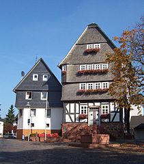
- 5 Hatzfeld (Eder) (Kilometre 47,5) - The town church St. Johannes (half-timbered building from the 14th century) and the Emmaus chapel (from the 12th century) are worth seeing.
- → Detour for Mountain goats: Who is sporty can to 9 Bagpipe drive up (approx. 15 km detour with approx. 300 m elevation gain). Best of all to the Hess. Follow the R8 long-distance cycle path via Lindenhof to the ridge (narrow asphalt road). At the mountain ridge 10 keep to the left and reach the summit after approx. 3 km over gravel forest paths. On the Bagpipe there is a lookout tower (entrance fee for donation). One has one from the Kaiser Wilhelm II tower beautiful panoramic view. The Lahn-Eder Hut des OHGV at the tower is only open on Sundays. On a forest path, however, you can quickly reach the "mountain hut", a restaurant on the edge of the local ski slope (with the sackpipe leisure center / summer toboggan run) that is not open all the time. (Is signposted).
From the summit it goes over gravel roads 11 down to Eifa. Via the L 553 you reach the Eder cycle path again at (in the valley at the road junction keep right towards Dodenau. After 200 m on the Edertalstraße you can turn left at 12 Drive onto the Eder cycle path above the parking lot.
- → Connection to the Lahn: The Hess. Long-distance cycle route R8 leads here over the mountains to Lahn valley cycle path at Wallau.


- ~ ~> The entire part of the € 2.3 million expensive Hessian Railway cycle path project from Beddelhausen to shortly before Dodenau is now passable. Two bridges over the Eder that have been prepared for cyclists are impressive (13 and 14 ) as well as a 325 m long tunnel 15 between Reddinghausen and Dodenau. The tunnel has automatic lighting and is open all year round. By the way, in front of the tunnel you will find one on the left Resting place (without refuge).

- 16 Dodenau (Kilometre 61,9) - Wildlife Park (about 3 km off the route up on the slope; 17
- ~ ~> Behind Dodenau there is an NSG with poor road quality (?).
- 1 Battenberg (Eder) - The small old town is up on the mountain with a nice valley view. If you want to visit the old town, join 18 off the route and drive or push over the very steep street "Am Herrenacker" or "Am Wassertor" about 500 m up to the old town. You have an even better panoramic view of the Edertal from the keep of the 19 Castle ruins in Battenberg (It is best to walk from the old town).

Battenberg (Eder) - Edersee (Dam): around 60 km
- 2 Battenberg old town (town hall) From the old town you drive downhill via Erfurter Straße (it is more of a path). At 3 you reach the route again. If you drive up the river, ideally branches off to the old town uphill.
- 4 Battenfeld (Local community Allendorf- The place is crossed on back roads. There is also a bicycle shop ("Elamis Bike Shop") 50 m to the left of the route in Marktstrasse.
- ~ ~> From Battenfeld the Eder valley widens. Between Battenfeld and Rennertshausen you pass on side streets at 5 Linspher cycle path or the "Winterberg - Allendorf (Eder)" cycle route. The cycle route is to Züschen im Rothaar Mountains well developed.
- ~

- ~ ~> Behind Rennertehausn, the cycle route to Frankenberg becomes traffic-free and runs first on asphalt, later on longer split sections. The route leads to Frankenberg on agricultural paths through the wide, open field markings. At the Ederbrücke south of Röddenau there is at 6 Connection to the Lahn-Eder cycle path Direction Marburg an der Lahn.
- ~

- 7 Frankenberg industrial area: roundabout on Jahnstrasse, Röddenauer Strasse On the left you will find shops for groceries.
- 8 Frankenberg - Old town with a half-timbered town hall and pedestrian zone.

- → Connection: The Hess. Long-distance cycle path R6: From Waldecker Land into the Rhine Valley, the Eder cycle path joins here and only runs independently again in Affoldern.
- ~ ~> From the Jahnstraße level crossing, the route crosses the Eder twice as a traffic-free cycle and footpath. Good to know: At the parking lot "Wehrweide" can be found at 9 a public restroom. Just behind the parking lot branches off 10 the Cycle route R 18 to Winterberg from. You leave Frankenberg via the "Hengstfurt". This is followed by an approximately 6 km long road, partly paved bike path to Viermünden. This cycle path runs within hearing and sight of the busy main road. The last 3.5 km to Viermünden are covered directly along the main road.
- ~
- 11 Viermünden center
- ~ ~> Around 4 km of gravel road west of the railway. The hilly route has a somewhat coarser gravel surface, but it is still satisfactorily drivable. However, depending on the load, you will notice the hills, especially with luggage.
- ~
- 12 Hessenstein Castle - houses a Youth hostel for ticket sales and youth groups. The castle is off the route and can only be reached via the main road in the Viermünden - Ederbringhausen section.

- 13 Ederbringhausen town center
- ~ ~> 14 Problem point between Ederbringhausen and Schmittlotheim on a narrow, largely natural path with a 12-15% steep hairpin (usually a pushing point for most touring cyclists). If you have a trailer with you or have a very heavily loaded bike, it is best to take the main road. The busy road does not have a cycle path, but there are sufficiently wide hard shoulders. If you orient yourself more to the right to the edge of the road, you can drive on the road more or less safely to close the gap. Tip: You can leave the main road after 2.3 km. The road contributes to this 15 cross and drive into the branching grass path. If you keep to the right, this will soon turn into a paved farm road. After 1.5 km you will meet the signposted route again at the Ederbrücke in Schnittlohheim. If there is a lot of traffic and a road crossing is not possible, simply follow the federal road for another 500 m. A well-developed farm road branches off diagonally to the right and leads all the way to Schmittlotheim. In the village then straight out of Lindenstrasse and follow the B 252 to the Ederbrücke.
- ~
- 16 Schmittlotheim train station - The village is about 1 km to the east. Anyone who has bypassed the problem area on the federal road will come back on the route here. The Edertalbahn is not in regular operation here, but a reactivation is planned. In the summer season there is tourist traffic again on weekends between Frankenberg and Herzhausen.

- ~ ~> Drive west of the train now on again developed farm roads to Kirchlotheim. From here it's almost 2 km on a road-accompanying bike path to Herzhausen. Before Herzhausen you can find the one on the right of the B 252 17 Kellerwald National Park Center visit. The modern adventure museum shows a modern exhibition on the flora and fauna of the Kellerwald-Edersee National Park. I.a. there is a special "4-D cinema". Gastronomy is affiliated.
- ~

- 18 Herzhausen (Vöhl) - Beginning of the Edersee, camping site, Badesse, Kellerwald National Park Center, Refreshment stops and places to stay overnight.

- The begins from Herzhausen Edersee. The leads around the "blue eye" of North Hesse Edersee cycle path. The use of the is recommended for touring cyclists South route at sea. This route is not only officially signposted as the Eder cycle path, but also has fewer inclines than the north route. On the south side of the Edersee you drive even more away from motor vehicle traffic.


- ~ ~> 19 From Ederbrücke Herzhausen 7.5 km less traveled district road to Asel-Süd. The traffic on this road is limited until the main days of excursions. However, it is sometimes driven quite quickly. In addition, the road is partly curvy. If you want to drive largely traffic-free, it is best to leave the Eder cycle path and drive via Herzhausen on the northern side of the dam to opposite Asel-Süd. In terms of landscape, this stretch of the Edersee Cycle Path on the north side of the dam is the more beautiful route anyway. However, the path is hilly and gravel for 3 km. 0.5 km of which are own quite rough, stony surfacewhich can still be ridden by experienced touring cyclists. If the short section is too difficult for you, you can simply push here and enjoy the beautiful landscape. Beware of the north variant: Inquire whether the Asel ferry is also in operation. When the Edersee is mostly empty, you can often see the Eder parallel to the ferry route in autumn and winter Cross on a historic stone arch bridge in Seeboden.
- ~
- 20 Asel-South - Campsite, refreshment stops, ferry to the north side of the dam
- ~ ~> Behind Asel, the Eder cycle path dives into the beech forest of the Kellerwald-Edersee National Park a. The hilly gravel road is good to satisfactory drivable. In terms of landscape, this 7 km long stretch is the most beautiful stretch of the dam. In front of the Banfebucht there is a nice rest area with a view of the lake (at 21 , but without a shelter). 1.5 km further you can find in the beautiful Keßbachtal at 22 but a refuge (just drive up the valley 500 m from the Banfebucht).
- ~


- 23 Bringhausen at the ship landing stage - Excursion catering, passenger boat trips in the direction of Waldeck and the barrier wall. Today, the village of Bringhausen is primarily a holiday home area with a campsite. The historical place in the bay had to give way to the dam construction around 1910 to 1914. Even today, when the water is low, the foundations of the former houses can be seen in the lake floor. If you want to hike in the national park, you should stay here at Edersee.
- ~ ~> After driving along the Bringhäuser Bay you will find at 24 still a public restroom. Now it goes on the bike and footpath up a hill to Rehbach. Above at 25 beautiful vantage point with a view of the lake (benches invite you to rest).
- ~
- 26 Rehbach at the campsite - Campsite with restaurants, public bathing beach (pebble beach), ferry to the Scheid peninsula
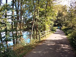
- ~ ~> From Rehbach beautifully landscaped, easily mobile, gravel riverside paths to the barrier wall. On the way you have from the hammer tip 27 (with bench-table combination) a beautiful lake view over to Waldeck. if the Edersee has extremely low water you can take a walk on the "Hopfenberge" far into the lake.
- ~

- 1 Edersee: Barrage wall west - excursion gastronomy, public restroom, Pier for passenger ships, aquapark. Guest beds close to the route can be found in Hemfurth directly at the barrier wall. Those who enjoy the diverse holiday region on Edersee do not know yet, it is best to plan at least one day's stay. There's a lot to discover.

Edersee (Dam) - kassel: about 60 - 65 km


- 2 Edersee: Barrage wall west - Tour start to the last stage along the lower Eder. The Eder is now quite a stately river. If water is also drained from the Edertalsperre in summer, it looks even fuller. The additional water drain serves to maintain shipping on the Oberweser. A "must stop" on this stage is the half-timbered town of Fritzlar.
- ~ ~> From the dam wall you drive on asphalt paths to Affoldern. At Affoldern, the cycle path follows the former Affoldern-Hemfurth railway line, which has been converted into a draisine route (approx. 2 km one way)
- ~ ~> Behind Flours begins the Ederauenlandscape with a mostly quite wide (not dredged) Eder and many small lakes that invite you to rest. For nature conservation reasons, the paths are only graveled or split on shorter stretches (but are usually easy to drive).
- Vega With 3 Rest area "Dorfmitte Wega" - There is an attractive rest area in the center of Wega. Here you will find a spacious, covered rest area with table and benches. A "fake water wheel" was built as a nice experience element. It rotates with water pumped in a circle. The offers a gastronomic offer Koppenretscher(Closed on Mondays and Tuesdays, otherwise partial opening times). Also stops here Kurhessenbahn at the old train station.
- → Possible Detour from Vega to Bad Wildungen (about 5 km easy on the R5).
- → 4 Alternatively: about 2 km before Fritzlar you can turn left into a pedestrian path (the signs probably only refer to the bridge, no signs in the opposite direction). It goes over a bridge and you reach a small lake. Then you can follow the Eder on a quiet, beautiful riverside path to Fritzlar. Turn right at the bridge. The Hess. Long-distance cycle route R4 follow to the Eder cycle path. The route is a natural path, but the Eder cycle path is hardly better.
- 5 Fritzlar - Here you can visit the old half-timbered town with the cathedral. The market square with (ice) cafés invites you to take a break. The signs now no longer lead cyclists directly to Wabern, but instead make a detour through the outskirts of Fritzlar. So you have a nice view of the city wall and the old town.
- → Large-scale alternative through the Chattengau: Equal in front the high road bridge at the end of the village on the left you can go into the Chattengauweg turn in. This over Werkel to 6 Gudensberg follow (both places are signposted). There on the railway cycle path to Edermünde-Grifte. The last section is already part of the Eder-Weg again. You save yourself a lot of bad roads and a few kilometers. However, the Eder cannot be seen and there are about 50 additional meters of altitude to be overcome (according to the cycle route planner).
- Wobble - The former hunting lodge can be seen from the bike path (photo). It is currently used as a psychiatric home for teenagers. Rail connection to the long-distance route (IC stop) Kassel - Frankfurt
- → Alternatively: the R17 (from Bahnhofstraße at 7 ) following one arrives at Schwalm cycle pathto start a little taster tour. Shortcut to the Schwalm Cycle Path: It's best to stick with it 8 on the forest road and turns Not right into the very wide path. In Felsberg you can meet at the train station 9 on the R12that you follow back to the Eder. The quality of the path is better and contains some nice views from the elevated town of Rhünda.
- 10 Felsberg (Hesse) - Country town with three castle ruins and a connection to the Chattengau-Fulda-Weg R12.
- ~ ~> hill (30 m) steep (8-10%) on a district road to the Grifte-Gudensberg cable car
- 11 Haldorf - From here the cycle path uses the old route of the Kleinbahn Grifte - Gudensberg , which is now developed as a cycle path. However, this last, short section is not paved. On the other hand, it is rustic on the shady slope of the Eder. A better economic route follows
- 12 Edermünde handles - at the entrance to the village shopping facilities (Aldi and REWE).

- ~ ~> After a roundabout comes the new, very scenic bike path along the Fulda. The new asphalt path was inaugurated in summer 2012. The route leads not directly at the Estuary past. If you want to have a look at it, you have to keep to the right behind the sewage treatment plant (dark blue sign with the words "Edermündung"). To the right of the premises of the fishing club (private; entry prohibited) one has been able to get there since May 2012 new, graveled cul-de-sac right up to the 13 Estuary. Here stands a Estuary monument or artwork of the Grifter Heimatverein.
- With a beautiful view of the imposing arched bridge of the Kassel-Bebra railway line, the route ends before Gunterhausen an der Fulda. Danger:
1. Sheep can lie on the way in the area of the railway bridge.
2. Before the bridge, the path is partly straight at risk of flooding. From a level of the Fulda of about 215-220 cm at the Gunterhausen gauge, the Fulda floods the way 14 bit by bit. The path should still be maneuverable up to a level of 225 cm, as the water is only a few centimeters deep. Then you can also move sideways into the slope-side meadow. The current water level in Guntershausen is can be viewed here. Barriers indicate the section of the path that is closed during floods. Unfortunately is missing At the roundabout in Grifte there is a folding sign pointing to the possibly blocked path with information on diversions. The barrier on the highly flood-prone part is about 1.5 km north of the roundabout. Bypassing during high floods towards Kassel:
1. From the Grifte roundabout it is advisable to drive to the R 1 via Guxhagen in the event of high water (detour 5 km, but good route).
2nd alternative: From Grifte you can take a hilly, z. Use some very bumpy gravel road towards Guntershausen (a small piece of 50 m is a steeper forest path sliding distance).
The third option is to drive on the county road from Grifte completely over the mountain to Guntershausen (60 meters in altitude).
- 15 End of route Baunatal-Guntershausen - Connection to the Hess on site. Long-distance cycle route R1: Fulda cycle route. From here it is about 15 km along the Fulda to Kassel with its sights. If you want, you can end the journey in Guntershausen and start your journey home by train from Guntershausen train station. Here, the track dough is only accessible via stairs.


trips
- On the Fulda cycle path to kassel
References to literature and maps
- bikeline bike tour book "Ederauen-Radweg: From the source in the Rothaargebirge to the Fulda", 1: 50,000, 72 pages, ISBN 3-85000-201-2 ,Esterbauer publishing house
- Natural experience of the Edertal. From the source to the mouth, Cognitio Verlag, Niedenstein 2007, ISBN 978-3-932583-25-4
digital maps
- Cycle route planner NRW - official website of the state of North Rhine-Westphalia. · Under "Themed routes"3rd position in the menu on the left and then"Supraregional themed routes“You will see the long-distance cycle routes in North Rhine-Westphalia. Choose "Further information"And from this page"To the card". · Under "The route planner"In the menu on the left and then"Themed routes“You can display all long-distance cycle routes on a zoomable map. · By setting the starting point and destination point, the route can be calculated with distance, elevation profile and elevation gain.
- Info, ·Map: Route of the Ederauen cycle path in the NRW cycle route planner
- Hesse cycle route planner - official website of the state of Hesse. · Under "Themed routes“3rd position in the menu on the left you will see the long-distance cycle routes in Hessen. Choose "To the card". · Under "The route planner"In the menu on the left and then"Themed routes“You can display all long-distance cycle routes on a zoomable map. · By setting the starting point and destination point, the route can be calculated with distance, elevation profile and elevation gain.
Web links
- www.eder-radweg.de - Site of the Touristik Service Waldeck-Ederbergland for the route
- Railway cycle paths - A circuit on the Ederauenradweg and the old railway line Gudensberg - Edermünde / Grifte