The Georgian Army Road (საქართველოს სამხედრო გზა / Sakartwelos samchedro gsa; Russian: Военно-Грузинская дорога, Voenno-Grusinskaya doroga; outdated too: Grusinische Heerstraße leads from Vladikavkaz above Stepantsminda and the cross passport Tbilisi.
background

The Heerstrasse connects 1 Vladikavkaz![]()
![]()
![]()
![]() in the russianNorth Ossetia-Alania With Tbilisi in Georgia. On the Russian side it bears the name
in the russianNorth Ossetia-Alania With Tbilisi in Georgia. On the Russian side it bears the name ![]() (until 2012: A-301), on the Georgian side the name
(until 2012: A-301), on the Georgian side the name ![]() . She is part of the
. She is part of the ![]() and the Asian Highway
and the Asian Highway ![]() .
.

history
The military road follows a millennia-old trade route over one of the lowest passes in the Caucasus. During the 5th Russian Turkish War (1768 to 1774) the Russian army expanded the route to a road for the transport of their troops. Under the command of General Gottlob Heinrich von Tottleben, the path was widened, routes were built into the mountains and bridges were built.
In 1799 the expanded Georgian Army Road became a public road. In 1827 General Alexei Yermolov took to the field against Chechens who regularly robbed travelers. Then the Russian administration secured the military road with Cossacks. Small living quarters and guard houses were built for them on the street at regular intervals.
The road surface was improved by 1863. A stagecoach line drove along Heerstrasse every day in both directions. The wagons were pulled by six to eight horses, and the animals were changed at various stations. From 1900 the carriages were replaced by cars.
During the Second World War, the 1st Panzer Army of the Wehrmacht attempted in autumn 1942 to block the road that was used to transport supplies for the Soviet troops north of the Caucasus, or to use it to advance south towards Georgia. However, the attack stalled outside Vladikavkaz in December 1942 without reaching the road.
In the interwar period, the Georgian Army Road was an important tourist route. Citizens of the Soviet Union were able to drive their own cars on them; from the 1970s, this was also possible for foreigners from other Warsaw Pact countries. The road was also accessible to citizens from the west, but mostly only via official, guided bus tours and not for individual tourists.
After the collapse of the Soviet Union and the independence of Georgia, conflicts escalated from 1991 onwards Abkhazia, South Ossetia and Dagestan to armed conflicts. As a result, the road and rail connections between Russia and the now independent states south of the Caucasus were repeatedly blocked. For a long time, the Georgian Army Road remained the only passable land connection between north and south. With the renewed war in South Ossetia in 2008, the border crossing on the Georgian Army Road was closed, and in 2010 it was reopened for Georgians and CIS citizens. The Dariali / Verkhnyj Lars border crossing has been open to all travelers again since 2012.
.jpg/220px-Georgian_Military_Road_map_(Moskvich_guide,_1913).jpg)
The Georgian Army Road: plan from a 1913 travel guide
.jpg/220px-Georgian_Military_Road_(Life_images;_1901).jpg)
Ascent to the Cross Pass from the north, 1901

Dariali Gorge: Postcard (ca.1890-1900
.jpg/220px-Georgian_Military_Road_map_(Moskvich_guide,_1913).jpg)
.jpg/220px-Georgian_Military_Road_(Life_images;_1901).jpg)

preparation
If you want to drive the entire length of the Georgische Heerstraße, you have to read the entry requirements for Russia and Georgia familiarize.
Recommended travel time: April to October. As one of the most important connecting roads in the region, the road maintenance authorities try to keep the route over the Cross Pass between Mleta and Kobi (almost 2400 m) passable all year round. However, if there is heavy snowfall, the pass road can be impassable for several weeks. As a result, it can happen that you are in Stepantsminda (Kazbegi) is stuck. The access from the south to the ski area Gudauri is usually kept passable.
Travel time: The 200 km long route can be covered by car in 4 hours (excluding border waiting times). Of Tbilisi off is the distance up Stepantsminda including visiting the most important sights on the way in a day trip.
Means of transport: The mode of transport of choice is your own car, as you can stop wherever you want. The route can be driven with a normal car, an off-road vehicle is not necessary. A motorcycle is also an option. The road is also passable with a bicycle, whereby a good off-road circuit is recommended for the steep inclines on the Kreuzpass. Due to the sometimes heavy traffic, cycling in the vicinity of Tbilisi is not recommended.
You can also use public transport on the road, for example with one of the numerous regular buses that run between Tbilisi and Stepantsminda, Gudauri and Passanauri, or with a long-distance bus between Russia and Georgia / Armenia. However, no stopovers for sightseeing are possible. Taxis and chartered tours are the means of transport of choice if you don't want to or can't drive yourself.
getting there
Touring the road starts from Tbilisi in the south or from Vladikavkaz in the North. Even if tourists travel the road mostly from Tbilisi, the route from Vladikavkaz should be described here, as this was the main historical direction (from the Russian Empire to the Transcaucasian regions).
security
The road has a high mountain character. Beware of tight bends and steep inclines, especially in bad weather (rain, snow). Also watch out for other drivers who overtake or jostle recklessly. Animals on the road don't care about the traffic, you shouldn't expect cows, donkeys or other animals to move just a millimeter to the side. Cows like to stay on bridges, because it is a little cooler.
The travel route
From Vladikavkaz to Verkhny Lars
In the city center of Vladikavkaz![]()
![]()
![]() begins the Army Road, it leads south, the Terek valley upstream to the Russian-Georgian border crossing at Verkhnyj Lars / 1 Dariali
begins the Army Road, it leads south, the Terek valley upstream to the Russian-Georgian border crossing at Verkhnyj Lars / 1 Dariali![]()
![]()
![]() .
.
.jpg/350px-Dariali_Gorge,_Georgia_(A).jpg)
From Dariali to Stepantsminda
In Georgia: The 10 km through the Dariali Gorge (also called Dariel Gorge / Dariel Pass) from the Dariali border crossing are winding and breathtaking. Sights en route:
- Tamaraszikhe monastery complex: A newly built monastery right next to the border crossing
- 2 Gweleti. A small nature park with 2 waterfalls about 2 kilometers from the road. You can get closer with an off-road vehicle on a difficult route, but the waterfalls can only be reached on foot via a steep trail. After an old container the path branches off, on the left 15 minutes 300 m to the small waterfall, on the right 20 minutes 450 m to the large one. Good shoes and a towel if you want to freshen up are helpful.
- 2 Thousand. is a small place with old, dilapidated houses and great mountain views. There is a remarkable cemetery on the way to the village.

The village of Tsdo

Gergetis Sameba


- 3 Stepantsminda


 in the Wikidata database") (Kazbegi) The first larger town on the Georgian side. There are hotels, restaurants, a petrol station and tourist infrastructure (travel guides, mountain guides, etc.). From Stepantsminda you can climb the summit of Mount Kazbek (5033 m).
(Kazbegi) The first larger town on the Georgian side. There are hotels, restaurants, a petrol station and tourist infrastructure (travel guides, mountain guides, etc.). From Stepantsminda you can climb the summit of Mount Kazbek (5033 m).

- Above the village, on the Kwemi Mta at 2170 m, is the domed church built in the 14th century 3 Zminda Sameba (გერგეტის სამების ეკლესია).(German Dreifaltigkeitskirche). The place of pilgrimage is connected to Stepantsminda by a road via Gergeti. An off-road vehicle is no longer required for the journey, an asphalt road now leads up and you can park in front of the church. On the new road there is a small hiking car park halfway up, from there a not too steep hiking trail with a lot of shady forest leads to the church, length approx. 1.5 km, approx. 150 m hike to Gergetis Sameba.

From Stepantsminda to Gudauri
- A few kilometers south of Stepantsminda, a road branches off to the east in Achchoti, where the villages 4 Sno. (Sno სნო).and5 Djuta. (Juta ჯუთა).lie. In Sno there is a small castle ruin and an academy of the Georgian Orthodox Church. Dschuta is the starting point for hikes to Chewsureti. On the side of the road between Achchoti and Sno there are head-high faces that were carved into the rocks by a local artist.
- In the village 6 Sioni. (სიონი).there is the Sioni Church of the same name.
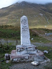
- The winding ascent begins after the village of Kobi. There are tunnels for the winter along the route that are bypassed in the summer. Left and right of the street you can see clusters of snack bars, tents or the like, often with sheep, always with a sign "Halal". The offer is aimed at Arab tourists who can buy a sheep that is then slaughtered on site according to Islamic regulations, then grilled and then eaten in the group. At the top of the pass, a memorial stone reminds of the fate of German prisoners of war who found their final resting place here.
- After the village of Kobi there is one on the western side of the road 4 Mineral water spring. The entire mountain slope was covered with a pink film by sintering.
- At the pass of the 2,395 m high 5 Cross pass (ჯვრის უღელტეხილი) a memorial stone indicates the fate of German prisoners of war who found their final resting place here.
- The is located shortly after the top of the pass 1 Monument to the Friendship of Soviet Peoples. (გუდაურის პანორამული გადასახედი)., where you also get a great panoramic view of the Aragvital.

The route over the Cross Pass, the monument to the friendship of the Soviet peoples in view
.jpg/220px-Gudauri_(13).jpg)
Skiing in Gudauri

.jpg/220px-Gudauri_(13).jpg)
- After you have passed an approximately 2 km long avalanche protection gallery with a breathtaking view of the valley of the Black Aragvi several hundred meters below, you reach Gudauri. Gudauri was once a small post office, but from 1980 it became the most important ski resort in the region. There are numerous ski lifts and hotels and restaurants of all price ranges, but most hotels and restaurants are closed in summer. Guaranteed snow from December to April also make the ski area a popular day trip for Tbilisi people. There is a Wissol petrol station in Gudauri that is open 24 hours a day.
From Gudauri to Pasanauri
- After getting to the ski resort 7 Gudauri and its appendages Cumliszikhe has crossed, the road becomes very winding again. There are several viewpoints with attached souvenir shops on the serpentine route. Locally made knitwear, honey, Tschurtschela (grape and nut snacks) and homemade schnapps are sold here.
- The locality Mleta is at the southern end of the pass. It is regularly hit by landslides and mudslides. In Mleta there is a small church from the 11th century.
- The road now follows the right bank of the river Tetri Aragvi (White Aragwi), who heaped up a mighty gravel bed in this area.
- At Naghvarevi there is a small spring of mineral water that is so ferrous that the entire area around the fountain is colored red.
- 1 HB Gudauri. Tel.: 995 595 35 31 13.
 HB stands for Hofbräu Munich. Restaurant with very good Georgian cuisine and Bavarian dishes on the menu. Bavarian interior with wall paintings. Probably Munich beer.Open: daily 9 a.m. - 11 p.m.

- 8 Passanauri is a small town on 2 confluence the rivers Tetri (white) and Shawi (black) Aragwi. There are numerous private accommodations and restaurants in Pasanauri. The restaurants of Pasanauri in particular are famous among Georgians for their khinkali. To the north of the village there is a small collection of old cars in a private garden. If you ask the owner nicely, you can view this collection.
- From Pasanauri you can take a short detour to Black Aragvi Valley at.


The Tetri Aragvi at Gudauri

From Pasanauri to Shinvali
- South of Pasanauri, the valley narrows, the road winds more curvy to the north end of the Shinwali reservoir. On the way you will find a beautiful old bus stop with a wall mosaic in the village of Zichisdsiri. Some dilapidated old Soviet buildings also exude an interesting charm. It also pays to drive into one of the numerous side valleys, although you need an off-road vehicle here.
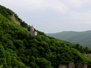
- Now you can reach the monastery and fortified church from 6 Ananuri.from the 17th century. This complex is one of the most important sacred sights in the country. In the vicinity of the church there are souvenir stands as well as some excursion restaurants.
- At Ananuri the road leaves the valley, which after the construction of the Shinvali reservoir has been flooded and is taking a higher route. In the 7 Dam wall shortly before the village of Shinvali there is another monument from the 1980s for the 300 Aragvel fighters.
- There is a petrol station near Shinvali. The road also branches off here Chewsuretia (Shatili) as well as the road to Tianeti and further after Kakheti from.

.jpeg/220px-Georgia_Ananuri_Castle_(240043711).jpeg)
The fortified church complex Ananuri
.jpeg/220px-Georgia_Ananuri_Castle_(240043711).jpeg)
From Shinvali to Natakhtari
After you have finally left the high mountains behind you, the course of the road becomes straighter. The villages are getting bigger and the forest and meadow next to the road are replaced by fields. Sights en route:
- The castle ruins 9 Bodorna is located shortly after 10 Aragwispiri at the junction after 11 Showereti
- The Basaleti lake located 5 km west of the road. At 12 Bodorna you have to branch off. The lake itself has next to the luxury beach hotel "Bazaleti" also some down-to-earth bathing beaches, which are often overcrowded in midsummer.
- In the village 13 Natachtari there is the brewery of the same name and the Barambo chocolate factory. There is also a small sports airport where you can charter helicopters and small planes (An-2).
- The road branches off in Natachtari Zilkani from where there is a worth seeing Fortified church is located.
.jpg/316px-Dusheti_(Photo_A._Muhranoff,_2011).jpg)
- After Natachtari one finally comes to the suburban area of the metropolis Tbilisi. Along the road there are numerous excursion restaurants, partly with kitschy design such as the Paulaner Tower. These restaurants are very popular with the big city dwellers, as the food is much cheaper here than in the city. They are accordingly overcrowded, especially on weekends, when loud live music of varying quality is played.
- The motorway junction with the ს 1 follows Mtskheta and Tbilisi go straight ahead, after Gori and beyond that you have to turn right.
Mtskheta and Tbilisi
The new motorway ს 1 bypasses Mtskheta east of the urban area. Below the Jvari Church, the ს 9, the Tifliser bypass road, branches off (signposted Baku, Yerevan). After Tbilisi it goes straight on.
The historical course of the Georgian Army Road runs through the city 14 Mtskheta![]()
![]()
![]() , one of the most important cities of the Georgian Orthodox Church. Here are the important churches and monasteries that
, one of the most important cities of the Georgian Orthodox Church. Here are the important churches and monasteries that


and Velvet avro, in the vicinity of the city further Jvari, Schio Mgwime and Zedazeni. Aside from churches, Mtskheta also has the ruins of Bebriszikhe castle and the archaeological site Armaszikhe (Bagineti) to see. More on this in the city article.
If you want to follow the historical road, coming from the north, follow the signs to "Mtskheta", drive through the city and, after crossing Mtkvari, turn left towards "Tbilisi". Coming from Tbilisi, leave the motorway in the direction of "Mtskheta", turn right at the roundabout over the bridge and through the city. In the north of the city you have to turn right onto the motorway towards Tbilisi, which you leave immediately and turn over a specially signposted ramp ("Sokhumi"). A few kilometers north you have to leave the motorway, "Stepantsminda, Gudauri (ს 3, E 117)" is signposted.
In the north of the city 15 Tbilisi![]()
![]()
![]() , at the district Dighomi, ends the Georgian Army Road. The striking end point is the monument to David the Builder.
, at the district Dighomi, ends the Georgian Army Road. The striking end point is the monument to David the Builder.

..jpg/220px-Mtskheta_(2011)..jpg)
View of Mtskheta from the Jvari Monastery, in the foreground the confluence of the Mtkvari (left) and Aragvi rivers

The end of the Georgian Army Road at the monument to David the Builder in the Tbilisi district of Dighomi
..jpg/220px-Mtskheta_(2011)..jpg)

literature
- Georgian Military Road on Wikipedia
- Daniel Nitsch: "A road connects the continents", Caucasian Post, August 2012
- Christian Mitschke: The Georgian Military Road, detailed travel report with many photos