| Himachal Pradesh | |
 | |
Location .svg/250px-Himachal_Pradesh_in_India_(disputed_hatched).svg.png) | |
| State | India |
|---|---|
| Capital | Shimla |
| Surface | 55,673 km² |
| Inhabitants | 6.856.509 (2011) |
| Tourism site | |
| Institutional website | |
Himachal Pradesh is a state ofIndia in the area ofNorthern Himalayas.
To know
Territories and tourist destinations
Urban centers
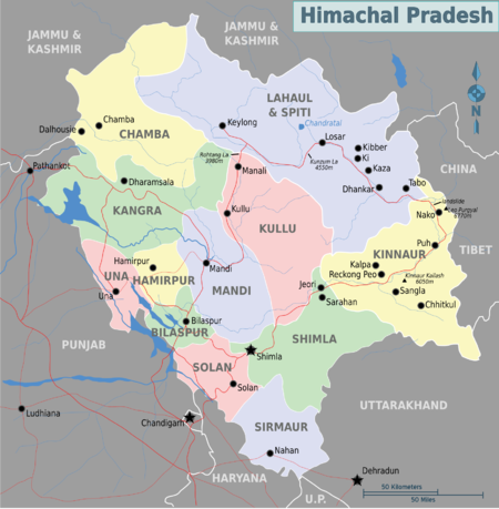
Map of the state Himachal Pradesh
- Shimla - Capital of Himachal Pradesh, Shimla it was the favorite health resort of the British. It still has many Victorian buildings from the colonial period.
- Chamba - Base for excursions a Bharmour (or Brahmpura), known for the beauty of its landscapes and its temples, some of which date back to the 10th century.
- Dalhousie - Colonial period health resort, along the road to Chamba.
- Gobind Sagar - An artificial lake in the district of Bilaspur.
- Keylong - The capital of Lahaul and Spiti, the northern district on the border with Tibet.
- Kullu - In the valley of the same name and on the banks of the Beas River 10 km north of Bhuntar airport. It is located along the road to Manali.
- Manali - The largest tourist center in Himachal Pradesh, very popular in summer.
- McLeod Ganj (Dharamsala) - The place where the Dalai Lama, (Tenzin Gyatso) since 1959, the year in which he was forced to abandon the Tibet after the failure of the attempt to drive out the occupation troops of the People's Republic of China |.
- Rewalsar (In Tibetan language: Tsopema) - A sacred lake for both Buddhism and Hinduism.
Other destinations
- Low altitude lakes - Renuka Lake, Macchial Lake.
- Medium altitude lakes - Dal Lake, Kareri Lake, Khajjiar Lake, Kumarwah Lake, Rewalsar Lake.
- High altitude lakes - Prashar Lake, Nako Lake, Chandra Tal, Suraj Tal, Dhankar Lake, Dashair, Brighu Lake, Seruvalsar Lake, Manimahesh Lake, Ghadhasaru Lake, Mahakali Lake, Lama Dal and Chander Naun.
- Artificial lake - Maharana Pratap Sagar, Lake Pandoh, Gobind Sagar.
How to get
How to get around
What see

The River Beas near Van Vihar, Manali
What to do
At the table
Safety
Other projects
 Wikipedia contains an entry concerning Himachal Pradesh
 Commons contains images or other files on Himachal Pradesh