| India | |
 | |
Location .svg/250px-India_in_its_region_(undisputed).svg.png) | |
Coat of arms and flag | |
| Capital | Delhi |
|---|---|
| Government | Federal parliamentary republic |
| Currency | Indian rupee (INR) |
| Surface | 3,287,263 km² |
| Inhabitants | 1.324.171.354 (2016 estimate), 1.210.854.977 (2011 census) |
| Tongue | English, Hindi and twenty-one other languages at the regional level |
| Religion | Hinduism 80%, Islam 14%, Christianity 2%, Sikhism 2%, Buddhism 1% and the rest atheists or minor religions (2000) |
| Electricity | 230V / 50Hz (European and British plug) |
| Prefix | 91 |
| TLD | .in |
| Time zone | UTC 5:30 |
| Website | Tourist Board of India |
India is a nation ofSouth Asia bathed by the Indian Ocean to the south, the Arabian Sea to the west and the Bay of Bengal to the east, which borders the Pakistan West, China, Nepal is Bhutan to the north-east, Bangladesh is Burma East.
To know
India today is a linguistic Babel: there are 22 official languages but beyond these, 200 unofficial languages and dialects are still spoken today. This simple statistic is proof of the country's ethnic mosaic as well as the result of the different civilizations that have alternated on its territory. India today is also a country of strong contrasts; is a country still largely rural made up of small villages where life flows as in the Neolithic times but also a country of large industries of technological innovation with cities such as Calcutta which are real human anthills.
India ranks seventh by area and second only to China by number of inhabitants. India prides itself on being the largest democratic republic in the world. It is also a very diverse country not only from a geographical and climatic point of view but also from an ethnic and cultural one.
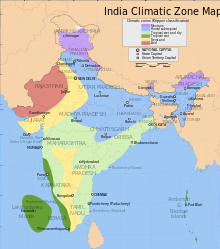
Alpine climate | IS | (ETh) | |
Wet subtropical | C. | (Cfa) | |
Tropical wet and dry | TO | (Aw) | |
Humid tropical | TO | (Am) | |
Semi-arid | B. | (BSh) | |
Arid | B. | (BWh) |

Below 20.0 ° C. | |
20.0-22.5 ° C. | |
22.5-25.0 ° C. | |
25.0-27.5 ° C. | |
Above 27.5 ° C. |
Geographical notes
Mountains, forests, deserts and beaches. India has it all. The borders to the north, north-east and north-west are marked by the Himalayan mountain range, the highest and largest in the world. In addition to being a perfect protective shield against enemies from the north, the mountains have always fed great rivers such as the Ganges, lo Yamuna (Jamuna) and the Sindhu (Indo) on whose plains Indian civilization flourished. Although today much of the Indus is in Pakistan five of its tributaries flow through the Punjab. The other Himalayan river, the Brahmaputra flows northeast through Assam.
South of Punjab is the chain of Aravalli which cuts the Rajasthan. The western part of Rajasthan is covered by the desert of Thar. THE Vindhyas they pass through central India, particularly through the Madhya Pradesh and mark the beginning of the plain of Deccan which almost entirely covers the southern part of the peninsula. It is sandwiched between the chain of Sahyadri to the west and the Eastern Ghats East. The plateau is more arid than the plains, as the rivers that supply it such as the Narmada, Godavari and the Kaveri during the summer they are dry. In the northeastern part of the Deccan plain is the area called Dandakaranya (once covered by forests) which extends over the States of Chhattisgarh, Jharkhand, the eastern part of the Maharashtra and the northern tip ofAndhra Pradesh. This area is still heavily forested, poor and populated by tribes. The forest acted as a barrier to the invasion of South India. India has a very long coastline. To the west is the sea of Arabia and to the east there Coast of Bengal.
The geography of India today derives from geological processes that began 75 million years ago, when the Indian subcontinent began a 50 million-year north-east drift, crossing the entire Indian ocean. The collision of the subcontinent with the Eurasian plate, gave shape toHimalaya which with its more than 8,000 meters is the highest mountain range on the planet, which now surrounds India to the north and north-east. In the ancient seabed immediately south of the emerging Himalayan peaks, the tectonic movement created a vast valley, which was subsequently filled with sediments from the rivers, giving birth to today's Indo-Gangetic plain. To the west of this plain, separated from the Aravalli mountains, is the Thar desert. The Satpura and Vindhya mountains in central India. These ranges run parallel to the Arabian Sea on the Gujarat coast, and further south lies a large territory called the Deccan Plateau, flanked to the west by the coastal ranges of the Western Ghats, and to the east by the Eastern Ghats.
The Himalayan range gives rise to great rivers which through northern India, including the Ganges and the Brahmaputra, flow into the Bay of Bengal. Important tributaries of the Ganges include the Yamuna and the Kosi, whose low slope of the territories it passes through causes disastrous flooding every year. The great rivers of the peninsula include the Godavari, Mahanadi, Kaveri, and Krishna, which flow into the Bay of Bengal; and the Narmada and the Tapti, which flow into the Arabian Sea. Among the most characteristic Indian coasts are the marshy Rann of Kutch in western India, and the alluvial delta Sundarbans, shared with the neighboring Bangladesh. India has two archipelagos: the Laccadives, coral atolls near the southwestern coast and the Andaman and Nicobar Islands, of volcanic origin located in the Andaman Sea.
When to go
In India, the rains are concentrated in very specific periods, that is during the season of monsoons. There are two of them, one of southwest and another of North East, so called according to the direction from which the winds blow. The southwest monsoon is the most important one, the one that causes rain over much of the country and is vital for crops (and consequently for the economy). It lasts from June to September, mainly affects the west coast which consequently turns out to be more verdant than inland. The northeast monsoon, on the other hand, hits the east coast between October and February, mainly in the form of occasional cyclones that cause devastation. The only region that is affected by both monsoons is northeastern India which as a result has the highest rainfall rate in the world.
In India there are three seasons: summer, the rain season (or the Monsoons) and the winter, even if in the tropics winter is characterized by temperatures around 25 ° C. In the north there can be peaks of heat and cold, but, except in the Himalayan region, snow is almost unknown. From November to January there is the winter season, with April and May being the warm months when rains are expected. There is a kind of short spring in February and March, especially in northern India.
There are conflicting opinions as to whether India has an "autumn" or not, but the ancient inhabitants had identified it as one of the six seasons (Vasanta - summer, Greeshma - summer, Varsha - rain, Sharat - Autumn, Shishira - winter, Hemanta - "mild winter") in which they had divided the year.
The Indian climate is heavily influenced by the Himalayas and the Thar Desert, which drives the monsoons. The Himalayas curb the cold winds of theCentral Asia, keeping most of the subcontinent at a higher temperature than regions located at similar latitudes. The Thar Desert plays a key role in attracting the winds of the summer monsoon, with a high humidity, between June and October, which provides most of the rains throughout the year. Four major climatic clusters predominate in the country: humid tropical, dry tropical, humid subtropical, and mountain.
Background
The Indians start their history from the Vedic period between 2000 and 1000 BC. This is the period in which the Vedas, the oldest sacred texts of the Hindu religion, were compiled. The earliest traces of civilization that have come down to us belong to the so-called Harappa civilization that flourished in the Indus valley in the 19th century BC. and then disappeared three centuries later for unknown causes, presumably due to a climate change that led to a prolonged drought or by the hand of warlike barbarian invaders. Excavations have shown that this civilization was extremely developed with urban centers equipped with advanced water and sewer systems. The cities were without fortifications and were in commercial relations with the states of the Gulf of Oman. According to the majority of historians, the peoples who inhabited these refined cities perished under the blows of the Vedic people of the Aryan race. According to a minority, however, the peoples of the Harappa civilization were already the Indo-Aris who would later elaborate the Vedas.
Conventionally, the Vedic period goes from 1500 to 500 BC. This was the time when the Vedas, the oldest and most sacred books of Hinduism, were compiled. They were written in an Indo-Aryan language, Vedic Sanskrit. Few details and archaeological finds are available for this period.
A section of the Mahabharata called the Bhagavad Gita is among the most widely read works. It is a dialogue, just before a great battle in Kurukshetra, between the hero Arjuna and the God Krishna who acts as his charioteer. Today Kurukshetra is a destination for both pilgrimage and tourism.
In the first millennium BCE, various schools of philosophical thought developed, greatly enriching Hinduism. Most of them claimed to be derived from the Vedas. However, some of these schools, two of which were Buddhism and Jainism, questioned the authority of the Vedas and are now recognized as separate religions.
Many great empires arose between 500 BC. and 590 A.D. Notable were the Maurya empires and the Gupta, both with the capital city of Pataliputra, now called Patna. The Gupta Empire (3rd century AD to 590 AD) is often called the golden age of India. Further west, the Gandharian civilization (an independent kingdom, later incorporated into the Maurya Empire) ruled over much of the territories that now sign Pakistan and Afghanistan. Their city Taxila became a great center of Buddhist culture.
Later there was a gradual decline of Buddhism and Jainism. The practice of Buddhism, in particular, disappeared from the heart of India and the Buddha himself was incorporated into the Hindu pantheon. Jainism, on the other hand, continued to be practiced by a significant minority who perhaps considered themselves Hindu. Hinduism itself underwent great changes. Vedic deities like Indra and Agni became less important while Puranic deities like Vishnu, Shiva, their various Avatars and family members gained importance.
The raids of Islam began towards the eighth century by pirates who later and gradually became masters of large areas in northern India. The most important of these governors were the Mughal who established an empire that at its maximum splendor covered almost the entire Indian subcontinent except the southern and eastern part. But this kingdom also fell, partly due to the attack of the gods Maratha who established a confederation almost as large as the Mughal Empire (and short-lived). During the Islamic period many Hindus converted to Islam, some forced others to break away from the caste system that relegated them to the lower states of society, so as to receive greater benefits for being aligned with the masters. today about 12% of the population is Muslim.
The south followed a different path as it was touched less by the Islamic invasion. The period from 500 to 1600 is the so-called "classical period" marked by the great kingdoms of the South. Chalukyas, i Rashtrakutas and the empire Vijayanagar who ruled from present-day Calcutta in addition to the kingdoms Pallavas is Cholas who ruled the area of today's Tamil Nadu. Literature in language Tamil, Kannada and Telugu flourished around that time and has been prolific ever since. Some of the largest Hindu and Jain monuments were built around this time in southern and eastern India where there were fewer religious restrictions.
European merchants began visiting India in the late 16th century. In the 19th century, the British "East India Company" had effectively taken control of every part of the Indian territory. A revolt was suppressed in 1857, but it was the turning point that prompted the British government to annex India to the Empire. During this period many Indians were converted to Christianity for the same reasons that many others had converted to Islam centuries earlier, although the conversions ended in 1857 when the Empire took over from the Company of India and Queen Victoria promised to respect Indian religious beliefs.
The non-violent resistance against the British led by Mohandas Karamchand Gandhi is Jawaharlal Nehru led to independence in 1947. The subcontinent was divided between the secular state of India and the smallest Islamic nation in the Pakistan.
India liberated and led by Nehru adopted a centrally planned and democratic economy. These policies were aimed at achieving "self-sufficiency", and they succeeded on an almost unknown level in the post-colonial world. For example, India achieved self-sufficiency in cereals during the 1970s in such a way as to make history the great famines that had been the norm. However, these policies have also led to shortages, slow growth and large-scale corruption. After a crisis in 1991 the country adopted free market reforms which continued at a cautious pace fueling strong growth. The IT and service industries have been the driving force behind this growth while the manufacturing sector and agriculture, which have not been affected by the reforms, have lagged behind. About 60% of Indians live on agriculture and about 25% live in poverty.
Relations with the Pakistan they are difficult. Three wars were fought (four counting the Kargil conflict of 1999) mainly for the control of the region Kashmir. The third war of 1971 resulted in East Pakistan becoming the Bangladesh. There China and India fought a war in 1962 over a border dispute. In India it was seen as a betrayal and the question is still open. Although relations are currently peaceful, military rivalry is still heated and there are no land border crossings between the two nations. Security issues on both the Pakistan and China fronts have led India to test nuclear weapons three times (including the 1974 tests described as "peaceful explosions"). India wants to be considered an "atomic power" and is seeking a seat on the United Nations Security Council.
India is proud of its democracy record. Constitutional rule and democratic freedoms have been safeguarded all these years except for a brief period in 1975, when the prime minister Indira Gandhi imposed a period ofemergency and suspended human rights.
India's current problems relate to disputes with Pakistan, overpopulation, corruption, environmental degradation, ethnic and religious conflicts and human rights issues, particularly with regard to women and homosexuals. One of the real obsessions, however, is whether and when India will be able to overtake China in economic growth.
Culture and traditions
The Indian Ministry of Tourism has launched a program to sensitize and educate tour operators to show more courtesy and attention to the needs of tourists. The initiative is called Atithi Devo Bhavah, an ancient Indian saying meaning "The guest is a God". This will be used as a mark, to certify that a tour operator ensures a minimum level of quality in the service. Look for the card or sticker with these words when you want to take a taxi, consult a travel agency, etc.
India has various cultures and traditions. It is probably the only country in the world where peoples of different origins, different religious beliefs, languages and cultural backgrounds manage to coexist.
Mahout (or cornac) - The person who drives an elephant. Generally the profession is handed down from father to son. The mahout he is seated on the animal's neck and communicates with him with gestures, foot movements but also words. Following this training, the elephant is able to understand fifty words. The elephant is still used as a means of transport in many areas of the Indian subcontinent lacking of road infrastructure. The word mahout is Hindi and in turn derives from Sanskrit mahamatra which means "one who has a great measure".
Territories and tourist destinations
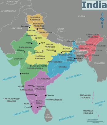
India is divided into 28 states and 7 territories. The states were created on the basis of linguistic rather than geographical criteria. Many have a significant extension comparable to that of a medium-sized European state, while others, like Goa they are very small and have less autonomy.
By convention, the states of India are grouped into the following macro regions:
Urban centers
- Delhi - The federal capital.
- Agra - the city that hosts the Taj Mahal, a famous temple dedicated to the "Love" of a Mughal prince for his lost bride.
- Ahmedabad - the most important city of the Gujarat on the banks of the Sabarmati river, home to an important textile industry which, before the English domination, exported precious richly embroidered silk fabrics to Europe, some of which are still visible in the Calico museum.
- Ajanta ed Ellora - Two locations in the state of Maharashtra not too far from each other and each with complexes of cave temples and frescoed caves. Both were declared by theUNESCOWorld Heritage .
- Amritsar - in Punjab. City that houses the Golden Temple, a place revered by the Sikhs.
- Bangalore - City ofSouthern India, known with various names including that of "Silicon Valley of India" thanks to the presence of industries related to information technology and in continuous expansion.
- Calcutta (Kolkata) - Capital of West Bengal and large industrial center.
- Chennai (former Madras) - State capital of Tamil Nadu with magnificent temples.
- Goa - Small state overlooking the Arabian Sea with beautiful beaches and incredible sunsets. Goa has been a traditional destination for youth tourism since it was discovered by groups of Hippies.
- Hyderabad - State capital of Andhra Pradesh. Fascinating city due to its mosques and its picturesque bazaars that are gathered around the "Char Minar", a triumphal arch of the sixteenth century that commemorates the end of a plague epidemic.
- Shimla - Famous health resort from the colonial period with an Anglo-Saxon air.
- Srinagar - City ofNorthern Himalayas, state capital of Kashmir, nestled on the shores of Lake Dal, in a grandiose alpine setting. Famous for boat trips (shikara) on the canals and nearby lakes.
Other destinations
India was the cradle of great religions and is still a country of mystics. Therefore, sacred places visited by hundreds of thousands of pilgrims on the occasion of religious holidays abound.
- Belur is Halebidu - Hoysala period monuments including the Chennakeshava temple erected at the end of the 14th century.
- Bidar - Karnataka city with interesting medieval monuments and, nevertheless, still off the beaten track by mass tourism.
- Hampi - Ancient capital of an incredibly prosperous Hindu kingdom, destroyed in 1585 by the Muslims who brought back a huge booty. Hampi is a vast open-air museum in the state of Karnataka.
- Konark - Temple on the east coast famous for the erotic sculptures that adorn it.
- Pattadakal - An exceptional group of Hindu temples in the central area of Karnataka.
- Pondicherry - Former French colony, today the territory of the Indian Union.
Sacred places
- Amarnath (Jammu and Kashmir) - Cave of God Shiva.
- Gangotri (Uttarkashi) - Village in the Himalayas (3,100 m a.s.l.), it is revered by Hindus as it is located on the banks of the Bhāgīrathī river, the main source of the Ganges.
- Gokarna — Udupi is Shringeri (Karnataka) - Three locations in the state of nell 'Southern India where you can learn Sanskrit and Hindu philosophy.
- Haridwar (Uttarakhand) - Haridwar is one of the important pilgrimage cities in India, where the festival of Kumbha Mela is also celebrated.
- Madurai (Tamil Nadu) - The "City of Temples". Sacred city to the followers of Shiva due to a temple dedicated to the goddess Meenakshi and Sri Sundareswara.
- Mathura is Vrindavan (Uttar Pradesh) - Two locations within a few kilometers of each other and both linked to episodes of the life of Krishna, one of the most popular divinities in India.
- Sarnath (Uttar Pradesh) - Location 10 km from Varanasi where Shakyamuni Buddha, after receiving enlightenment, conceived the doctrine of Dharmachackra.
- Shravanabelagola (Karnataka) - A place revered by the followers of Jainism.
- Tiruchirappalli (Tamil Nadu) - Another city in the deep south of India, home to a shrine dedicated to Swami Ranganatha which stands on an islet in the Kaveri River (Cauvery).
- Tirupati is Tirumala — (Andhra Pradesh) - There is the temple of Sri Venkateshvara Perumal (The Supreme Lord of the Mountain), dedicated to Vishnu.
- Vaishno Devi (Jammu and Kashmir) - Vaishno Devi is a famous temple dedicated to Shakti (Power). It attracts crowds of devotees.
- Varanasi (Uttar Pradesh) - One of the sacred cities along the banks of the Ganges. According to Hindu beliefs, those who manage to die in Varanasi automatically interrupt the cycle of reincarnations. Famous for the gath, the steps leading down to the Ganges (whose water is extremely polluted).
How to get
Entry requirements
In most cases it is necessary to obtain a visa, which must be requested on relative official site; for tourism, business or medical reasons it is very often possible to apply for an electronic visa, the cost of which is reported in this file[link not working].
To visit Sikkim, Arunachal Pradesh, Nagaland, Manipur, Mizoram and remote areas of the states of Jammu and Kashmir, Himachal Pradesh, Uttar Pradesh it is necessary to apply for the "Protected Area Permit" (PAP), issued by the Ministry of the Interior only for groups of at least 4 people who have signed a travel plan proposed by a registered Tour Operator. However, it is possible to do this to the consular authorities in Italy who will issue a similar permit valid for 15 days. This permit, however, will only be valid for entry into major centers and surroundings and will not allow excursions off the beaten path.
For Italian citizens
Passport with residual validity of at least six months and entry visa. L'Italian embassy it is found at Delhi.
Visa for India can be requested in Milan, in via Marostica, 34 at the Indian Visa Outsourcing Center (tel 02 48701173). The delivery time is approximately 1 week.
In Rome, the consular section of theembassy of India in via XX Settembre nº5. FAX 39 064 824 252.
By plane
The airports of Mumbai is Delhi often constitute the main entrance for those coming fromItaly.
London it is a good springboard to India with affordable tickets sometimes offered on the companies' own website British Airways, Air India, Virgin Atlantic Airways and others. The condition for having a cheap ticket is usually to book well in advance.
Among the possible alternatives we mention:
- Lufthansa - It manages among other things a flight from Frankfurt to Bangalore useful for those interested in exploring theSouth India
- Air France offers flights from various Italian cities with a stopover in Paris.
- Austrian Airlines - From various Italian cities with a stopover in Vienna.
- Swiss Air - With a stopover in Zurich.
It is also worth browsing the airline websites Middle Eastern and Gulf countries such as Qatar Airways, Kuwait airways is Royal Jordanian
By car
There is only one step from Pakistan.
There are several ports along the Indian peninsula. The biggest ones that do passenger service are Bombay is Chennai, while the others do freight services.
On the train
By train India can be reached from Nepal and from Pakistan.
From Nepal you enter a Khajuri in the district of Dhanusa in Nepal to Jaynagar in Bihar, a connection operated by the Nepalese railways.
There are two borders with Pakistan: Samjhauta Express from Lahore to Attari close Amritsar in Punjab. The Thar Express he resumed service in February 2006 after a 40-year hiatus. It goes to Munabao in Rajasthan in Khokrapar in the Pakistani province of Sindh.
The train is certainly not the quickest or most practical way to get from India to Pakistan due to the long border controls, but it is certainly a very fascinating way to travel. Better to walk through Attari / Wagah.
By bus
Buses arrive from Nepal every day and arrive at New Delhi, Lucknow is Varanasi. However, it is cheaper to take a bus and get to the border, get off, cross the border and then take another bus and continue. The India / Nepal borders are Sunauli / Bhairawa from Varanasi, Raxaul / Birganj from Calcutta, Kakarbhitta from Darjeeling and Mahendrenagar-Banbassa from DelhiThe main route for those arriving in India from Pakistan is the one from Amritsar to Lahore. Despite the tension between the two nations, there are still many travelers who choose this route. Immigration procedures can be lengthy. It takes about a full day to go from Amritsar to Lahore with local buses. Usually you can first take a ticket from Amristar to the border, walk across and then take another bus to Lahore although you may need to make other changes along the way.
There is also a line through Kashmir, but the area is not safe and not worth it.
How to get around
By plane

As with hotels, foreign visitors are generally required to pay a higher price than locals on domestic flights. Unfortunately, tickets cannot be purchased online. In fact, the airlines only accept credit cards issued in India. Below is a list of airlines that operate domestic flights.
- Air India Express - The low-priced version of Air India.
- SpiceJet - A fearsome competitor of the Kingfisher Red.
- Go air - A low cost airline.
- Jagson Airlines - Flights also to Bhutan and the Nepal.
- MDLR Airlines[link previously not working] - Mainly operates on routes in northern India. Delhi-Calcutta.
- IndiGo Airlines - A low cost company.
On the train

The body that manages the railways is theIndian Rail.
The reservation must be made as soon as possible. Seats and couchettes on long-distance trains can in fact be purchased as early as 90 days before departure. This means they sell out soon.
It is true that on some trains, a small percentage of seats or couchettes are reserved exclusively for foreign visitors who are in possession of an "Indrail Pass". It will be necessary to pay for these seats in dollars or pounds sterling or even in rupees but in the latter case it will be necessary to show the certification of the exchange at the bank or the receipt of the ATM.
Another possibility is given by waiting lists. It may be that someone gives up the trip and you can buy a ticket for that empty seat.
Every major city in India has an office where foreign visitors can buy tickets thus avoiding the long queues at the station. There is an office of the railway authority at the Delhi airport where you can make reservations. It is open 24 hours a day.
The reservation, as previously written, must be made well in advance. For this reason, the railway authority makes an online site available to interested parties www.irctc.co.insurprisingly simple according to some but complicated according to others. Anyone wishing to experience it must first register with an ID and password. There is a limit to online purchases: you cannot exceed 10 tickets per month. If you think you are overstepping this limit then it is best to buy an "IndRail pass".
Of course, tickets purchased online will never be sent to you in Italy. You just have to print a copy which you will then show together with your passport to the inspector who will ask you for it. This option, called the "e-ticket option", works great on the "Shatabdi" and "Rajdhani" express trains. The booking system is in fact totally computerized on these two types of train. There is only a very small surcharge to pay. Even if you have lost your printed data, you will still be able to travel if of course you remember your ID and have a passport. You will pay a few extra coins, nothing else.
Nel caso, piuttosto raro, che il treno prescelto non presenti la "e-ticket option", allora il biglietto acquistato sarà spedito per posta a un indirizzo in India che voi stessi specificherete (per esempio l'albergo dove soggiornerete) ma in questo caso sarà necessario avvertire l'albergo in quanto il postino richiederà la lettera con la quale è stato richiesto il biglietto. Basterà che voi inviate la lettera all'albergo via fax o e-mail. Il servizio postale non è attivo per i piccoli centri ma solo per le grandi città. È tuttavia improbabile che voi entriate in India da qualche piccolo centro.
A differenza dei siti delle compagnie aeree che effettuano voli domestici, il sito delle ferrovie accetta carte di credito dei circuiti Visa, MasterCard o Amex che siano state emesse all'estero. Il sistema vi mostrerà quindi una lista di banche chiedendovi con quale di queste volete effettuare la transazione (A detta dei più Citi e Axis Bank sono le migliori). Dopo aver effettuato il pagamento riceverete una e-mail di conferma da parte dell'Ente che avrete la premura di stampare e portare con voi come spiegato dianzi.
L'alternativa è acquistare un "IndRail pass" on line sul sito della rappresentanza delle ferrovie indiane nel Regno Unito [1]
Altre informazioni più dettagliate sul sito seat61.com (in English)
Tipi di treno
I treni in India possono essere super-fast, express/mail, fast passenger, passenger o suburbani.
- Rajdhani Express — Questo tipo di treni i cui compartimenti sono tutti dotati di aria condizionata hanno solo cuccette. Viaggiano tra la capitale federale e le altre capitali di stato.
- Shatabdi Express — L'unica differenza con i precedenti è che non hanno cuccette (solo posti a sedere)
- Jan Shatabdi Express — Treni intercity con posti a sedere e cuccette. Alcuni vagoni hanno l'aria condizionata altri no.
- Garib Rath Express — Treni notturni con cuccette e posti a sedere. Tutti i vagoni hanno l'aria condizionata.
By bus
What see
Se si vogliono visitare tutti i luoghi turistici indiani, anche una visita di 6 mesi è senza dubbio insufficiente. Ci sono più mete turistiche in India che in un libro completo, per non parlare di una sintesi. Quasi ogni stato dell'India ha più di dieci destinazioni turistiche importanti e ci sono città che a malapena si possono visitare in una settimana intera. Diversi stati indiani da soli sono più grandi e più popolosi della maggior parte dei paesi del mondo.
What to do

Le escursioni in kottavalam (case galleggianti) per le lagune e i canali del Kerala costituiscono un'esperienza memorabile del viaggio in India. Alcune di queste case-flottanti sono state adibite ad albergo.
Currency and purchases
La valuta nazionale è la Rupia indiana (INR). È suddivisa in 100 paisa. Circola in banconote da 5, 10, 20, 50, 100, 500 e 1000. Ogni taglio è contraddistinto da un colore particolare. Le monete in circolazione sono da 25 paise, 50 paise, 1 Rupia, 2 Rupie e 5 Rupie.
Below are the links to know the current exchange rate with the main world currencies:
| (EN) With Google Finance: | AUDCADCHFEURGBPHKDJPYUSD |
| With Yahoo! Finance: | AUDCADCHFEURGBPHKDJPYUSD |
| (EN) With XE.com: | AUDCADCHFEURGBPHKDJPYUSD |
| (EN) With OANDA.com: | AUDCADCHFEURGBPHKDJPYUSD |
Tra i souvenir da portarsi eventualmente a casa gli oggetti artistici in legno intagliato, i dipinti, anche su seta e cotone e gli articoli di bigiotteria del resto facilmente reperibili in certe zone di Rome (Piazza Vittorio) is Milan.
Articoli in oro e gioielli hanno un prezzo interessante ma bisogna avere un occhio esperto. Gli oggetti in oro sono generalmente a 24 carati, molto d'effetto ma si ammaccano facilmente
At the table
La cucina indiana è caratterizzata da una grande varietà di stili regionali e sofisticati, con uso di erbe e spezie, ad esempio il garam masala. I prodotti alimentari di base sono il riso (in particolare nel sud e nell'est) e il frumento (soprattutto nel nord). Tra le spezie originarie del subcontinente indiano ed ora consumate in tutto il mondo si segnala il pepe nero.Un esempio di dolce tipico a base di yogurt è lo shrikhand. La cucina dell'India del nord, che fa uso di carni, è meno speziata, a differenza di quella del sud, che è vegetariana e più speziata. La cucina, soprattutto nei ristoranti, viene anche classificata in cucina non vegetariana (indicata da cartelli con la scritta "non veg"), latto-ovo-vegetariana ("veg", senza carni), e latto-vegetariana, detta quasi vegana ("pure veg", che non fa uso di uova). Praticamente inesistente la cucina vegana propriamente detta, cioè senza neanche latte e latticini.
Tourist infrastructure
Il Ministero del turismo indiano ha lanciato un programma per sensibilizzare ed educare gli operatori turistici a mostrare più cortesia ed attenzione ai bisogni dei turisti. L'iniziativa è denominata Atithi Devo Bhavah, un antico detto indiano che significa "L'ospite è un Dio". Questo verrà usato come marchio, per certificare che un operatore turistico assicuri un livello minimo di qualità nel servizio. Cercate la tessera o l'adesivo con queste parole quando volete prendere un taxi, consultare un'agenzia viaggi, eccetera. [2].
Events and parties
National holidays
Ci sono tre feste nazionali che cadono lo stesso giorno ogni anno:
- Giorno della Repubblica il 26 gennaio
- Giorno dell'Indipendenza il 15 agosto
- Gandhi Jayanti il 2 ottobre
La maggior parte delle feste religiose invece cade in giorni diversi, perché le feste induiste e islamiche si basano sui rispettivi calendari che sono diversi da quello gregoriano.
Safety
- Polizia: 100
- Vigili del fuoco: 101
- Pronto soccorso: 102
Health situation
Respect the customs
How to keep in touch
Keep informed
Other projects
 Wikipedia contains an entry concerning India
 Commons contains images or other files on India
 Wikiquote contains quotes from or about India
 Wikinews contains current news on India

![]() Afghanistan ·
Afghanistan · ![]() Saudi Arabia ·
Saudi Arabia · ![]() Bahrain ·
Bahrain · ![]() Bangladesh ·
Bangladesh · ![]() Bhutan ·
Bhutan · ![]() Burma ·
Burma · ![]() Brunei ·
Brunei · ![]() Cambogia ·
Cambogia · ![]() China ·
China · ![]() Corea del Nord ·
Corea del Nord · ![]() South Korea ·
South Korea · ![]() United Arab Emirates ·
United Arab Emirates · ![]() Philippines ·
Philippines · ![]() Japan ·
Japan · ![]() Jordan ·
Jordan · ![]() India ·
India · ![]() Indonesia ·
Indonesia · ![]() Iran ·
Iran · ![]() Iraq ·
Iraq · ![]() Israel ·
Israel · ![]() Kirghizistan ·
Kirghizistan · ![]() Kuwait ·
Kuwait · ![]() Laos ·
Laos · ![]() Lebanon ·
Lebanon · ![]() Maldives ·
Maldives · ![]() Malaysia ·
Malaysia · ![]() Mongolia ·
Mongolia · ![]()
![]()
![]() Nepal ·
Nepal · ![]() Oman ·
Oman · ![]() Pakistan ·
Pakistan · ![]() Qatar ·
Qatar · ![]() Singapore ·
Singapore · ![]() Syria ·
Syria · ![]() Sri Lanka ·
Sri Lanka · ![]() Tagikistan ·
Tagikistan · ![]() Thailand ·
Thailand · ![]() East Timor ·
East Timor · ![]() Turkmenistan ·
Turkmenistan · ![]() Uzbekistan ·
Uzbekistan · ![]() Vietnam ·
Vietnam · ![]() Yemen
Yemen
Stati con riconoscimento limitato: ![]() Stato di Palestina ·
Stato di Palestina · ![]() Taiwan
Taiwan
Stati solo fisicamente asiatici[1]: ![]() Armenia ·
Armenia · ![]() Azerbaigian[2] ·
Azerbaigian[2] · ![]() Cyprus ·
Cyprus · ![]() Georgia[2] ·
Georgia[2] · ![]() Kazakhstan ·
Kazakhstan · ![]() Russia ·
Russia · ![]() Turkey
Turkey
States de facto independent: ![]() Abcasia[2] ·
Abcasia[2] · ![]() Artsakh ·
Artsakh · ![]() Northern Cyprus ·
Northern Cyprus · ![]() Ossezia del Sud[2]
Ossezia del Sud[2]
Addictions Australian: ![]() Isole Cocos e Keeling ·
Isole Cocos e Keeling · ![]() Isola di Natale
Isola di Natale
Addictions British: ![]() Akrotiri and Dhekelia[3] ·
Akrotiri and Dhekelia[3] · ![]() Territorio britannico dell'Oceano Indiano
Territorio britannico dell'Oceano Indiano
Stati parzialmente asiatici: ![]() Egypt (Sinai) ·
Egypt (Sinai) · ![]() Greece (Isole dell'Egeo settentrionale, Dodecaneso) ·
Greece (Isole dell'Egeo settentrionale, Dodecaneso) · ![]() Russia (Russia asiatica) ·
Russia (Russia asiatica) · ![]() Turkey (Turchia asiatica)
Turkey (Turchia asiatica)