| Artsakh | |
 | |
Location  | |
Coat of arms and flag  | |
| Capital | Step'anakert |
|---|---|
| Government | presidential republic |
| Currency | Dram karabakho (NKD) |
| Surface | 11,458 km² |
| Inhabitants | 150.932 (2015 census) |
| Tongue | Armenian (de facto) Azerbaijani (de jure) |
| Electricity | 220V / 50Hz (European and German socket) |
| Prefix | 37447 |
| Time zone | UTC 4 |
| Website | Tourism site |
| ATTENTION: In the area of the Nagorno Karabakh, although not officially in a state of war, military activities take place between theArmenia is Azerbaijan, therefore we strongly advise against any visit to the region (December 2020) | |
Artsakh, officially Republic of Artsakh (Արցախի Հանրապետություն, Artsakhi Hanrapetut’yun, ex Nagorno Karabakh Republic), from the name of the homonymous historical region, is de facto a state with limited recognition, not recognized by any UN member, self-proclaimed independent fromAzerbaijan, part of the Caucasus; bordered to the west by theArmenia, to the south with theIran to the north and east with theAzerbaijan.
To know
Located in Southern Caucasus, in the Artsakh region (also "Upper Karabakh" or "Mountainous Karabakh"). The current territorial borders were determined at the end of the conflict that broke out in January 1992, after the proclamation of independence and roughly correspond to those of the ancient Armenian region of Artsakh. Some portions of the territory (part of the Shahoumyan region and the eastern edges of the Martouni and Martakert regions) are under Azerbaijani control despite being claimed by the Armenians as an integral part of their state.
Geographical notes
Along the northern side are high mountain ranges, i Mrav mountains which reach 3,700 meters of altitude (Mount Gamish, 3724 m); equally mountainous to the west and south while to the east the territory becomes progressively flatter with the two corners, the provinces of Martakert and Martowni (corresponding to parts of the Azerbaijani districts of Kəlbəcər, Tərtər and Xocavənd), also flat. Other valleys exist around the reservoir of Sarsang, to Hadrowt ', and in the south. Much of Artsakh is covered with forests, especially the mountainous areas. The southern side along the border with theIran.
The region is crossed, from west to east and from north to south, by several rivers that flow mostly into the Kura or the Aras: the Vorotan, the Karkar, the Tartar, the Khachenaget, the Hakari and others. minor torrential courses. In addition to the artificial basin of Sarsang there are some small lakes of glacial origin on the Artsakh plateau near the mountain ranges that surround it to the north and west.
When to go
The climate is milder than that ofArmenia, with less hot summers and less severe winters; in July and August the average temperature is around 22 ° C with variations due to the altimetric values of the localities; in winter the average temperature is just below zero.
Background
Artsakh was the name of one of the provinces of the Great Armenia. The territory, located in the southern Caucasus, has undergone numerous invasions and dominations over the centuries but its population has always been largely Armenian and Christian. In the early 1920s the Karabakh People's Councils repeatedly requested annexation to Armenia as 95% of the population was of that ethnicity. Despite the favorable opinion of the Caucasus Office of the Central Committee of the Communist Party, Stalin decided in 1921 to assign the territory to Azerbaijan, Turkish and Muslim. In 1923, the Autonomous Oblast of Nagorno Karabakh was created. With the progressive weakening of the Soviet apparatus, at the end of the 1980s, the Armenian aspirations for reunification with the Motherland revived. When in 1991 Azerbaijan decreed its exit from the Soviet Union, the Soviet of Nagorno Karabakh, exploiting the legislation of the time, announced the birth of the republic of Nagorno Karabakh-Artsakh. This decision was confirmed by a referendum which was followed by political elections monitored by international observers. On January 6, 1992 the new republic was officially proclaimed; on January 30, the Azerbaijani army attacked Nagorno Karabakh and essentially started the war that will end with the Armenian victory and the 1994 ceasefire agreement.
Following the conflict, the Armenians not only maintained control over the original territory of the autonomous Oblast (about 4,400 sq km) but also extended it to the neighboring regions (in Azerbaijani rajon), which were also part of the ancient Artsakh thus a territorial contiguity with Armenia. Today the total area is approximately 11,450 sq km. The republic of Artsakh, divided into eight regions including the district of the capital Stepanakert, is a state in all respects even if not recognized internationally; presidential, political and administrative elections are held on a regular basis, there is a central bank, the state university, the telephone company and national radio and television.
Before the constitutional referendum of 20 February 2017, the state had the official name of Nagorno Karabakh Republic (Լեռնային Ղարաբաղի Հանրապետություն, Lernayin Gharabaghi Hanrapetutyun).
Spoken languages
The official language is theArmenian, used in the oriental version. In practice, a local dialect typical of the region is spoken and different from the Armenian used in theArmenia. Frequently spoken is also the Russian and, especially in urban centers and tourist facilities, theEnglish.
A large part of the population also knows theAzerbaijani, but even if you know this language, you should refrain from using it so as not to cause resentment in your interlocutor.
Suggested readings
- Nadia Pasqual, Armenia and Nagorno Karabakh, Polaris Guides, 2010
- Mauro Morellini, Armenia and Nagorno Karabakh, Morellini Editore, 2017
- Emanuele Aliprandi, The reasons of Karabakh, AndMyBook, 2010
- Guenter Lewy, The massacre of the Armenians, Einaudi Scuola, 2006
- Gabriella Uluhogian, The Armenians, Il Mulino, Bologna, 2009
Territories and tourist destinations
Artsakh is divided into seven regions, plus the capital Step'anakert which is a city with a special status.

Urban centers
- Step'anakert (in AzerbaijaniXankəndi) - Capital of this state de facto.
- Berjor (or Berdzor, ex Laçın)
- Hadrowt ' (or Hadrut, or Hadrout)
- K'arvač̣aṙ (or Karvachar, in AzerbaijaniKalbajar or Kelbajar)
- Martakert (or Mardakert, in AzerbaijaniAğdərə or Aghdara)
- Martowni (or Martuni or Martouni, ex Khojavend)
- Vank (in AzerbaijaniVəngli)
- Şuşa (or Shushi or Shusha)
Other destinations
- Ağdam - Ghost city.
- Monti Mrav - Mountain range with peaks between 3,000 and 4,000 meters.
How to get
Entry requirements
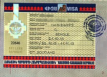
A visa is required and can be requested from the NKR representation a Yerevan(Armenia) and which is usually valid for twenty-one days.
- Visa office, 17 Nairi Zaryan Street, ☎ 37410 24 97 05, @[email protected].
 The visa for one month costs 24.000,00 dram (about 50 euros).
  Mon-Fri. Passport photos are required for the visa. In exceptional cases, the visa can be issued from the headquarters of the Ministry of Foreign Affairs a Step'anakert (also closed on Saturdays and Sundays). To the page http://www.nkr.am/en/consular-service/92/[link not working] you can download the bilingual form (Armenian/English) for the visa.
 | Visa restrictions: The stamp of the Republic of Artsakh in the passport precludes access toAzerbaijan. |
By plane
| To learn more, see: Airports in Armenia. |
The airport of Step'anakert, rebuilt between 2011 and 2012, is not yet operational.
By car
Access to the Republic of Artsakh can only be done through theArmenia being the border with theAzerbaijan closed since the war. The border withIran it is not yet equipped with customs gates. There are two main connecting arteries: the first is the road (M 12) which from Goris (southern Armenia) reaches Berdzor (document checkpoint) and from here to the capital; it is a road in excellent maintenance conditions. From Goris you go up to a plateau and you reach the border between Armenia and Artsakh (on the right there is an indicative sign in Armenian language). Then you go back down to what was once called the "Lachin Corridor": immediately after crossing the Aghanovjur river (hydroelectric plant) you will find the border post for checking documents. On the opposite side you can see a khatchkar placed at the intersection of the road leading to the monastery of Tzitzernavank. The M 12 then continues towards Berdzor and sinuously climbs towards the Artsakh plateau.
The second communication route, recently inaugurated, connects the M 11 state road (from Martakert) to Vardenis in Armenia through the Sotk pass. The road is in excellent condition, with a wide carriageway and a series of hairpin bends reached 2,700 meters above sea level. of the pass; precisely as a consequence of the altitude it is advisable to check the weather conditions in the middle of winter and in any case travel on adequately equipped vehicles. The border and document control post is located downstream, at the beginning of the ascent. This communication route with Armenia is shorter than the one from Goris and saves at least two hours of travel.
By bus
Regular buses travel from the Armenian capital to that of Artsakh (on average 6/8 hours of travel). There are also private cars that offer the connection service with a significant saving of time (check the fare before leaving). Taxis with a fixed rate of one hundred dollars leave from Yerevan airport but it is possible to book in advance the most economically advantageous solutions.
How to get around

The areas close to the border withAzerbaijan they are forbidden to travelers for safety reasons and can only be visited with special permits. It is not advisable to venture into these areas without adequate accompaniment, also due to the risk of mines.
By car
Internal movements only take place on the road. In addition to the arteries that come fromArmenia, there is another fast connection from the city of Martakert (in the north) to that of Hadrowt ' (to the south). The main road network is good as a whole; it becomes precarious in its connections with rural mountain villages often served by unpaved roads. The road signs are written in Armenian and Latin characters in the main centers, while the signs for the villages are mainly only in Armenian characters
On the train
There is no railway network.
By bus
From the capital Stepanakert there are bus lines that connect the countries of the region and the main towns of the state. Since the summer of 2018, the Department of Tourism has launched three itineraries with tourist minibuses for the most interesting places. Check information at the department website (Artsakh travel) or at the kiosk in Piazza della Rinascita (in front of the Parliament).
What see


Artsakh is a predominantly mountainous region, covered by abundant forests especially in its northern part, full of medieval fortresses and monasteries, some of which can only be reached by walking along mountain paths.
The capital Step'anakert it is the starting point of almost all excursions being positioned almost in the center of the country.
The neighbor Şuşa with its fortress it is recovering from the wounds of the war and focuses heavily on culture and art.To visit the museums, the ancient part (still in ruins after the war), the mosque under restoration
The most interesting sites are the religious ones: Gandzasar Monastery and Dadivank Monastery, in the north, are the best known.
All the complexes rise in an elevated position, with very suggestive landscape views.
The chain of Mrav mountains to the north it offers suggestive sceneries.
What to do
Currency and purchases
The national currency is the Dram karabakho although in fact it is the Armenian Dram (AMD), which has a 1 to 1 exchange rate with the karabakho one. Here are the links to know the current exchange rate with the main world currencies:
| (EN) With Google Finance: | AUDCADCHFEURGBPHKDJPYUSD |
| With Yahoo! Finance: | AUDCADCHFEURGBPHKDJPYUSD |
| (EN) With XE.com: | AUDCADCHFEURGBPHKDJPYUSD |
| (EN) With OANDA.com: | AUDCADCHFEURGBPHKDJPYUSD |
Commercial hours generally require the offices to be closed on Saturdays and Sundays, observing 9: 00–17: 00 from Monday to Friday. The shops, on the other hand, are generally open every day of the week until 19:00.
At the table
Tourist infrastructure
The level of the tourist offer is rising as is the increase in visitors. The capital has good hotels, including four-star hotels, with good services. Hotel accommodation is also decent in the province. It can be interesting (and certainly more traditional) to take advantage of the offer of private homes.
Events and parties
| Date | Festivity | Note | |
|---|---|---|---|
| January | New Year | International holiday | |
| January | Christmas | ||
| January | Defender of the Fatherland Day | Also celebrated in the nearby Armenia, commemorates and praises the actions of the Artsakh army | |
| March | International women's day | International anniversary | |
| April | Day of mothers and beauty | It is an Armenian festival also celebrated in the small republic of Arstakh in which the beauty of Armenian mothers who receive gifts and flowers from their children is celebrated. | |
| April | Commemoration of the Armenian genocide | ||
| May | International Workers' Day | International holiday | |
| May | Liberation of Shushi, birth of the Artsakh Defense Army, victory in the Patriotic War (2nd World War) | ||
| June | Children's day | International holiday | |
| June | Commemorative day for the fallen and missing in war | ||
| September | Independence Day | ||
| December | Day of remembrance of the earthquake in Armenia | It is a public holiday recognized by the Armenian government and de facto also by the artsakho one to commemorate the victims of the earthquake that struck Armenia in 1988. | |
| December | Day of the Constitution and the Referendum for independence | ||
Safety
There are no particular problems of public order or delinquency; following military activity in 2020, however, safety for travelers has decreased to such an extent that it is not recommended to visit it.
Before embarking on the journey consult the Safe travel site of the Ministry of Foreign Affairs for updated information on the security ofAzerbaijan since Artsakh is still officially part of it.
Health situation
There are no compulsory vaccinations; the general safety rules for water and unpackaged food products are recommended.
Respect the customs
How to keep in touch
Telephony
Good coverage compatible with the conformation of the territory; to avoid problems it is suggested to buy prepaid cards in Armenia which allow good coverage also in the Republic of Artsakh. The company "Karabakh Telecom" provides voice and data services and the cards can be purchased throughout the country.
Internet
Coverage is provided in cities and small towns; more difficult in rural or mountain areas.
Keep informed
The information is provided by state radio and television (Artsakh TV) and various print media. Azat Artsakh is the main national newspaper; there are also several local publications.
Other projects

![]() Afghanistan ·
Afghanistan · ![]() Saudi Arabia ·
Saudi Arabia · ![]() Bahrain ·
Bahrain · ![]() Bangladesh ·
Bangladesh · ![]() Bhutan ·
Bhutan · ![]() Burma ·
Burma · ![]() Brunei ·
Brunei · ![]() Cambodia ·
Cambodia · ![]() China ·
China · ![]() North Korea ·
North Korea · ![]() South Korea ·
South Korea · ![]() United Arab Emirates ·
United Arab Emirates · ![]() Philippines ·
Philippines · ![]() Japan ·
Japan · ![]() Jordan ·
Jordan · ![]() India ·
India · ![]() Indonesia ·
Indonesia · ![]() Iran ·
Iran · ![]() Iraq ·
Iraq · ![]() Israel ·
Israel · ![]() Kyrgyzstan ·
Kyrgyzstan · ![]() Kuwait ·
Kuwait · ![]() Laos ·
Laos · ![]() Lebanon ·
Lebanon · ![]() Maldives ·
Maldives · ![]() Malaysia ·
Malaysia · ![]() Mongolia ·
Mongolia · ![]()
![]()
![]() Nepal ·
Nepal · ![]() Oman ·
Oman · ![]() Pakistan ·
Pakistan · ![]() Qatar ·
Qatar · ![]() Singapore ·
Singapore · ![]() Syria ·
Syria · ![]() Sri Lanka ·
Sri Lanka · ![]() Tajikistan ·
Tajikistan · ![]() Thailand ·
Thailand · ![]() East Timor ·
East Timor · ![]() Turkmenistan ·
Turkmenistan · ![]() Uzbekistan ·
Uzbekistan · ![]() Vietnam ·
Vietnam · ![]() Yemen
Yemen
States with limited recognition: ![]() State of Palestine ·
State of Palestine · ![]() Taiwan
Taiwan
Only physically Asian states[1]: ![]() Armenia ·
Armenia · ![]() Azerbaijan[2] ·
Azerbaijan[2] · ![]() Cyprus ·
Cyprus · ![]() Georgia[2] ·
Georgia[2] · ![]() Kazakhstan ·
Kazakhstan · ![]() Russia ·
Russia · ![]() Turkey
Turkey
States de facto independent: ![]() Abkhazia[2] ·
Abkhazia[2] · ![]() Artsakh ·
Artsakh · ![]() Northern Cyprus ·
Northern Cyprus · ![]() South Ossetia[2]
South Ossetia[2]
Addictions Australian: ![]() Cocos and Keeling Islands ·
Cocos and Keeling Islands · ![]() Christmas Island
Christmas Island
Addictions British: ![]() Akrotiri and Dhekelia[3] ·
Akrotiri and Dhekelia[3] · ![]() British Indian Ocean Territory
British Indian Ocean Territory
Partially Asian states: ![]() Egypt (Sinai) ·
Egypt (Sinai) · ![]() Greece (North Aegean Islands, Dodecanese) ·
Greece (North Aegean Islands, Dodecanese) · ![]() Russia (Asian Russia)
Russia (Asian Russia) ![]() Turkey (Asian Turkey)
Turkey (Asian Turkey)

![]() Albania ·
Albania · ![]() Andorra ·
Andorra · ![]() Armenia[1] ·
Armenia[1] · ![]() Austria ·
Austria · ![]() Azerbaijan[2] ·
Azerbaijan[2] · ![]() Belgium ·
Belgium · ![]() Belarus ·
Belarus · ![]() Bosnia and Herzegovina ·
Bosnia and Herzegovina · ![]() Bulgaria ·
Bulgaria · ![]() Cyprus[1] ·
Cyprus[1] · ![]()
![]()
![]() Vatican CITY ·
Vatican CITY · ![]() Croatia ·
Croatia · ![]() Denmark ·
Denmark · ![]() Estonia ·
Estonia · ![]() Finland ·
Finland · ![]() France ·
France · ![]() Georgia[2] ·
Georgia[2] · ![]() Germany ·
Germany · ![]() Greece ·
Greece · ![]() Ireland ·
Ireland · ![]() Iceland ·
Iceland · ![]() Italy ·
Italy · ![]() Latvia ·
Latvia · ![]() Liechtenstein ·
Liechtenstein · ![]() Lithuania ·
Lithuania · ![]() Luxembourg ·
Luxembourg · ![]() North Macedonia ·
North Macedonia · ![]() Malta ·
Malta · ![]() Moldova ·
Moldova · ![]() Principality of Monaco ·
Principality of Monaco · ![]() Montenegro ·
Montenegro · ![]() Norway ·
Norway · ![]() Netherlands ·
Netherlands · ![]() Poland ·
Poland · ![]() Portugal ·
Portugal · ![]() UK ·
UK · ![]() Czech Republic ·
Czech Republic · ![]() Romania ·
Romania · ![]() Russia[3] ·
Russia[3] · ![]() San Marino ·
San Marino · ![]() Serbia ·
Serbia · ![]() Slovakia ·
Slovakia · ![]() Slovenia ·
Slovenia · ![]() Spain ·
Spain · ![]() Sweden ·
Sweden · ![]() Switzerland ·
Switzerland · ![]() Ukraine ·
Ukraine · ![]() Hungary
Hungary
States de facto independent: ![]() Abkhazia[2] ·
Abkhazia[2] · ![]() Artsakh[1] ·
Artsakh[1] · ![]() Northern Cyprus[1] ·
Northern Cyprus[1] · ![]() Donetsk ·
Donetsk · ![]() Kosovo ·
Kosovo · ![]() Lugansk ·
Lugansk · ![]() South Ossetia[2] ·
South Ossetia[2] · ![]() Transnistria
Transnistria
Addictions Danes: ![]() Faroe Islands
Faroe Islands
Addictions British: ![]() Akrotiri and Dhekelia[1] ·
Akrotiri and Dhekelia[1] · ![]() Gibraltar ·
Gibraltar · ![]() Guernsey ·
Guernsey · ![]() Jersey ·
Jersey · ![]() Isle of Man
Isle of Man
Marginally European states: ![]() Kazakhstan[3] (Atyrau, Western Kazakhstan) ·
Kazakhstan[3] (Atyrau, Western Kazakhstan) · ![]() Turkey[3] (Eastern Thrace)
Turkey[3] (Eastern Thrace)