| Aran Islands | |
 | |
Location  | |
| State | Ireland |
|---|---|
| Region | Galway county |
| Surface | 51 km² |
| Inhabitants | 1.251 (2011 census) |
Aran Islands it is a small archipelago Irish.
To know
The group consists of three small islands located in the wide bay of Galway on the Atlantic side ofIreland. Inishmore it is the largest and also the one with the greatest tourist flow. The other two are Inishmann is Inisheer
Background
About 340 million years ago large layers of limestone were deposited in the west of Ireland. Subsequently the glaciation eroded them and at the end of the last ice age 11,000 years ago, the sea level increased by 100 m. This separated the Aran Islands from the limestone area of the mainland now known as "Burren"in County Clare. The smooth limestone plateau began to crack. There was no land, no trees, and very little fresh water, because the rain penetrated underground. The rock of the Burren is full of cave systems that maybe one day they will also be discovered on the Aran Islands.
It was a bleak prospect for agriculture. In the cracks in the rock, soil collected which allowed only the growth of wild flowers of the alpine type. Fishing was essential for the nourishment of the population. The islands were places to escape from, not to conquer. The first wave of population dates back to 1100 BC. circa, although a tomb on Inis Meáin dates back to at least 2500 BC. One thing that was not lacking was the rocks. Large stone forts were erected and the fields were cleared by piling stones in the dry stone walls that span the islands.
The first Christian refugees from the mainland, later revered as saints, settled in the 6th century and medieval churches were built on their tombs. These are now in ruins but survive because they have not been remodeled. Together with the forts, they are today the main tourist attraction.
Spoken languages
The three islands are Gaeltachtaí, areas where Irish is the primary language, spoken by almost everyone as a first language. All are fluent in English, but the signs are in Irish: the English equivalents (eg "Inisheer" for Inis Oírr) are unofficial. This article provides both versions, but emphasizes the English version simply to help with pronunciation.
Territories and tourist destinations
- 1 Inis Mór it is the largest and most visited of the islands, with prehistoric and early Christian sites and spectacular cliffs.
- 2 Inis Meáin, the central island, is the least touristy.
- 3 Inis Oírr, the smallest and closest to the mainland, has prehistoric forts but mostly its ruins are medieval.
Urban centers
- Kilronan - The port where the boats coming from Doolin.
How to get
There are two ferry routes from the mainland: from Rossaveel, 40km west of Galway, all year round and from Doolin, County Clare, in the summer. All ferries leave for Kilronan on the island "Inis Mór", taking 40 min; and stop at the islands "Inis Oírr" and "Inis Meáin" on the outward or return journey. This can mean a sailing time of 90 minutes to an island closer to the mainland. Day trips are possible. You cannot bring any vehicles (not even a motorbike) to the Aran Islands, you must park in Rossaveel or Doolin wherever it does not bother the residents or users of the port.
- From Rossaveel the Aran Island Ferries they sail at least twice a day throughout the year, up to eight a day in midsummer. In summer 2020 a return fare for adults was € 30. A shuttle bus from Eyre Square to Galway connects with all the islands, return fare € 9.
- From Doolin the ferry Doolin or the Doolin2Aran Ferries sails 3 or 4 times a day from March to October taking 40 minutes, foot passengers only, € 30 return.
How to get around
Ferries from the mainland always call at Inis Mór and usually the other islands. This means that a trip between the islands is possible every day of the year.
The islands can be visited mainly in feet. On Inis Meáin and Inis Óirr it will probably be your only method, as those islands are compact, everything is within a kilometer or two and the paved roads soon give way to boreen, stone and grass paths.
Inis Mór however is 14km long, with a cluster of attractions 2-3km east of Kilronan village, so the main attractions are 7-10km west. The main road is paved and rental is strongly recommended bicycles standard or mountain bike.
All the islands have tours, by minibus or by pony cart. It is also possible a day trip from Dublin by train and plane, a frantic excursion. These are a good option if you are short on time or if the weather is uncertain, but you will be foul-mouthed with a large group of tourists and may miss the characteristic atmosphere of this pleasant place.
What see


- 1 Dún Aengus. It is the most famous of the many prehistoric stone forts on the Aran Islands. It is located on the largest of the three islands, Inis Mór, on a spectacular limestone cliff overlooking the Atlantic Ocean at a height of about 100 meters. It is in the shape of an amphitheater, originally it was oval in shape but has lost one half due to the erosion of the cliff. A popular and popular tourist destination, Dún Aengus is above all an important archaeological site: built during the Bronze Age and dating from well before the first millennium BC, it has often been referred to as the most magnificent barbaric monument in Europe ("the most magnificent barbarian monument in Europe"). The name "Dún Aengus" means "Fort of Aengus", referring to the pre-Christian pagan deity described with the same name from Irish mythology. Other well preserved prehistoric forts on Inis Mór they are Dún Dúchathair, Dún Eochla and Dún Eoghanachta.
- Dún Conor. is the main prehistoric site on Inis Meáin. Carrownlisheen's tomb dates back to at least 2500 BC.
- The early Christian sites. Several saints came here, around the sixth century, some to settle but others to continue their mission on the mainland: Aran has the same role for theIreland that Iona play for the Scotland and the Mount Athos for the Greece. Around the X-XII century. there was a phase of construction of places of worship on ancient prehistoric sites. Examples on Inis Mór are St. Enda, the complex of Seven Churches, San Ciaran and Teampall Bheanáin. Up Inis Meáin there is Templesaghtmacree and Inis Oírr has the churches of St Cavan and St Gobnait.
- O'Brien's Castle. up Inis Oírr it dates back to the 15th century, with many other medieval ruins nearby.
- Headlights. The first lighthouse a Inis Mór it was located in the wrong place and you can't see it anyway. It still stands, but was replaced in 1857 by the lighthouses on the Brannock Rocks just west of Inis Mór and on Inis Oírr.
Events and parties
- Ted Fest. Held in March by TV sitcom fans "Father Ted", first shown on Channel 4 in 1995-98. Most of the TV locations were on land, but the opening scene of" Craggy Island "shows the coast of Inis Oírr. The Ted Fest to date has held only on Inis Mór, but organizers hope to extend it to other islands.
- Cleasthon. It is a road race held in late spring on Inis Oírr. The distances are 5km, 10km and 20km, they don't stretch for a marathon.
- Craiceann Bodhran Festival. It is a masterclass and concert series featuring Irish bodhran drums. It is held in Inis Oírr for four days in June.
- Currach Racing. It is held in August off the coast of Inis Oírr. A "currach" is a traditional light rowing boat.
What to do
- Sea. All the islands have sheltered sandy beaches on the north side. But after the swim you will need a hot drink! The strangest bathing experience is the Serpent's Hole on Inis Mór, a rectangular pool connected to the sea by a submerged passage.
- Scuba dive. There are numerous dive sites around the islands. There are no diving facilities so you will need to be self sufficient. Dry suit recommended.
Shopping
Sweaters are produced on the Aran which over the course of the twentieth century have considerably increased their fame also worldwide. Made with fairly coarse wool, they are characterized by designs made up of various styles (about 5-6) that run vertically through the sweater, often including the sleeves.
How to have fun
Where to eat
Where stay
Safety
How to keep in touch
As of June 2020, on Inis Mór in Kilronan and a little further up the west coast you will receive a telephone signal. There is no coverage anywhere else on these islands, although individual properties and ferries may have a connection.
Around
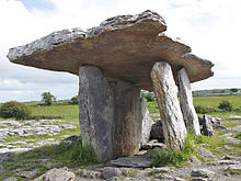
- 4 Dolmen of Poulnabrone. On the mainland, off the Aran Islands, is Ireland's oldest dolmen (a primitive construction made of overlapping slabs), dating back to the Neolithic period, built with a funeral function.


- 5 Cliffs of Moher. Extraordinary cliff overlooking the sea, exceptional to see both from the top and from the base.
Other projects
 Wikipedia contains an entry concerning Aran Islands
 Commons contains images or other files on Aran Islands