
The Marmara region lies in the northwest of the Turkey and is the country's bridge and connection to Europe, with Turkey's largest city, Istanbul, in its heart. The area has been inhabited for thousands of years and is home to a variety of archaeological sites and relics from the past. The present offers everything from water sports to skiing, or relaxing on the beach.
Regions
The Marmara region includes the European part of Turkey (Eastern Thrace) and parts of Anatolia, which is the Asian part of Turkey.
The provinces of Edirne, Kirklareli and Tekirdağ are located in Eastern Thrace. The provinces of Çanakkale and İstanbul are located in both Europe and Asia. In Anatolia there are the provinces of Balikesir, Bilecik, Bursa, Kocaeli, Sakarya and Yalova.

places
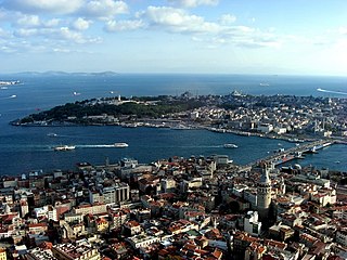
- 1 Istanbul


 in the Wikidata database") - Lively metropolis on two continents, tourist magnet and usually the first port of call
- Lively metropolis on two continents, tourist magnet and usually the first port of call
- 2 Adapazari - The late antique Sangarius Bridge with a length of 429 m is not far from the city, the surrounding lakes such as Sapanca and Poyraz Gölü are popular with those looking for relaxation, Keltepe (1610 m) is a destination for hikers and ski fans

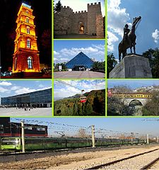
- 3 Bursa - The first impression of the city may be that of a large, concrete-laden modern metropolis that denies its widely recognized Turkish nickname Yeşil Bursa ("Green Bursa") and its historical significance as the cradle of the Ottoman state; On closer inspection, however, you will find that the city lives up to its name by proudly displaying its Ottoman heritage in the form of many mosques, tombs and beautiful old neighborhoods, as well as many nice parks that give the city fresh air and offer the tired traveler some shade to rest - and even if the parks are not enough to give this city the title "green", then the lush forest area of Mt. Uludağ is just above the striking hill. In 2014, Bursa and the nearby Cumalıkızık village were added to the UNESCO World Heritage List. The remains in multiple locations illustrate the creation of an urban and rural system in the Ottoman Empire in the early 14th century.

Hagia Sofia, Istanbul

Adapazari
.jpg/386px-ULU_CAMİİ_MOSQUE_BURSA_TURKEY_-_panoramio_(18).jpg)
Bursa


.jpg/386px-ULU_CAMİİ_MOSQUE_BURSA_TURKEY_-_panoramio_(18).jpg)
- 4 Çanakkale - is located on the southern, Asian bank of the Dardanelles, which connect the Aegean Sea with the Marmara Sea and at the same time separate Europe from Asia. It is now a vibrant city due to the large number of students at the local university. The region, steeped in history, has been inhabited for thousands of years and offers the traveler a rich legacy of the past.

- 5 Edirne
 - is the capital of Eastern Thrace. The city lies in the gently rolling Thracian plain at the confluence of three rivers, near the borders with Greece and Bulgaria. Most visitors crossing these borders continue straight east or stay seated on the bus or train to reach Istanbul. But Edirne was the capital of the Ottoman Empire for a while and is still an imperial vacation spot today, adorned with magnificent mosques. The city is definitely one of the top tourist attractions in Turkey.

- 6 İzmit - is a large and highly industrialized city east of Istanbul, at the end of the sword-shaped Gulf of İzmit, the long indentation of the Sea of Marmara to the east. İzmit is the capital of the province Kocaeli.

.jpg/339px-Çanakkale_(8709566664).jpg)
Çanakkale

Edirne

İzmit
.jpg/339px-Çanakkale_(8709566664).jpg)


Other goals
- 1 Troy (Hisarlık Tepe) - archaeological site on a hill about 15 meters high, believed by science to be ancient Troy. Twelve layers of settlement were found from a period of 3500 years up to Roman times. Discovered in 1873 by the German businessman and archaeologist Heinrich Schliemann.
.jpg/320px-Walls_of_Troy_(2).jpg)
- The 2 Uludag At 2542 m, it is the highest point in the Marmara region. There are warm springs, a winter sports area and a national park in the vicinity. According to Greek legend, it was from the mountain that the gods pursued the Trojan War.

.jpg/300px-Walls_of_Troy_(2).jpg)
The walls of Troy

Uludag
.jpg/300px-Walls_of_Troy_(2).jpg)

Islands
- 3 Bozcaada - lovable island with beautiful beaches, attractive architecture and a citadel

- 4 Gokceada - is the largest island in Turkey, with a small Greek community (which the island Imbros call) and abandoned villages.

.jpg/336px-Bozcaada_-_panoramio_(13).jpg)
Bozcaada

Gokceada
.jpg/336px-Bozcaada_-_panoramio_(13).jpg)

background
The European part of Turkey is the former Thrace. It is separated from the Asian part by the Marmara Sea. This is connected in the north with the Black Sea by the strait of the Bosphorus, in the southwest the connection is the strait of the Dardanelles. The term "Marmara" comes from ancient Greek.
language
Although it is possible to come across villages established by immigrants from the Balkans in the early 1900s, where the ancient people speak the Pomak dialect of Bulgarian or another Balkan language is Turkish by far the most common and useful language, as in most parts of Turkey.
getting there
By plane
The new airport ![]() Istanbul Airport
Istanbul Airport![]()
![]()
![]()
![]() (IATA: IS) in Arnavutköy 40 km northwest of the city center, is now the main international arrival point to Turkey.
(IATA: IS) in Arnavutköy 40 km northwest of the city center, is now the main international arrival point to Turkey.

The other international airport in this region is the ![]() Istanbul Sabiha Gokcen Airport
Istanbul Sabiha Gokcen Airport![]()
![]()
![]()
![]() (IATA: SAW) in the Asian part of Istanbul, which is often used by low-cost airlines.
(IATA: SAW) in the Asian part of Istanbul, which is often used by low-cost airlines.

Other regional airports with domestic flights are the ![]() Tekirdag-Corlu-Ataturk Airport
Tekirdag-Corlu-Ataturk Airport![]()
![]()
![]() (IATA: TEQ), the
(IATA: TEQ), the ![]() Bursa-Yenisehir Airport
Bursa-Yenisehir Airport![]()
![]()
![]() (IATA: YEI) and the
(IATA: YEI) and the ![]() Canakkale Airport
Canakkale Airport![]()
![]()
![]() (IATA: CKZ).
(IATA: CKZ).


By train
There are trains to:
- Istanbul from Bulgaria, Greece and a number of other Balkan countries via Edirne.
- Istanbul from various places in Central and Eastern Turkey via Izmit and Eskişehir as well as from Tehran, Iran.
- Bandirma on the southern Marmara coast from Izmir.
- Edirne near the Bulgarian border is the end point of the motorail train that runs from Villach during the season Optima Express.
By bus
All cities and many villages in Turkey have direct daily bus connections to Istanbul. Many cities in the neighboring Balkan countries also have bus connections to Istanbul. Bursa, as a large city, is also associated with a large number of cities and towns in Turkey.
In the street
The Marmara region is well connected to neighboring regions and countries by a network of motorways and expressways. There are many border crossings to Bulgaria and Greece.
By boat
In the summer months there is a weekly ferry connection from Izmir to Istanbul.
mobility
On the Bosporus, 3 bridges and a tunnel in Istanbul connect Europe with Asia, and there are also ferry connections.
By boat
There is an extensive network of ferry and high-speed ferry lines that connect the north and south coasts of the Marmara Sea, drastically reducing travel time. Most high-speed ferry lines fan out from Istanbul towards the cities on the south coast, while conventional ferries can be found between almost every city on the north and south coasts (e.g. the Tekirdağ-Gemlik line which covers almost the entire sea crossed from northwest to southeast).
On the Dardanelles there are car ferries from Gelibolu to Lapseki and from Eceabat to Çanakkale.
Tourist Attractions
As both the Byzantine and Ottoman empires had their centers here, there are a number of imperial monuments from both eras in the Marmara region. While the Byzantine monuments are mainly found in Istanbul, there are a number of intact artifacts in historically important but now provincial cities such as İznik, Tirilye and Vize. The Ottoman monuments, on the other hand, can be found almost everywhere in the region, but most of them can be seen in Bursa, Edirne and Istanbul - the three successive capitals of the empire.
- The magnificent 5 Selimiye mosque dominates the Edirne skyline. It is the masterpiece of Mimar Sinan, built 1569-75, and is a UNESCO World Heritage Site. The eight pillars that support the dome are inconspicuous, giving the impression that the dome is hanging over the interior, while 999 windows let in a flood of light. Four dainty ribbed minarets tower over 70 m in height. The inside is decorated with calligraphy and geometric patterns in pink and blue. The inverted tulip ornament, a landmark of Edirne, is intended to pay tribute to the former landowner who was reluctant to give up his tulip garden for the construction of the mosque.


The dome of the Selimiye Mosque

activities
From water sports to skiing
kitchen
The most important wine regions in the region are in the Şarköy region on the Marmara coast of Eastern Thrace, the Marmara island of Avşa and the Aegean island of Bozcaada, which has a wine tradition going back thousands of years.
The town Susurluk in the south is known nationwide for their local frothy ayran, which is available at many rest stops along the main Istanbul-Izmir highway.
- Iskender kebab, the lamb grilled on a rotisserie is thinly sliced and served with flatbread, yoghurt, grilled peppers and tomatoes. At the table, melted butter is poured over it. The court was İskender Efendi Invented in Bursa in the late 19th century. Today his descendants run a chain of restaurants where, in addition to starters (meze), only the original Kebapçı İskender is served.
- Peynir helvası is a dessert with the main ingredients: full-fat sheep cheese, flour, sugar, water or milk, margarine and oil. The specialty in Çanakkale is that semolina is also used.
- İzmit is famous for its Pişmaniye, a dessert made of soft threads of butter and sugar, comparable to cotton candy. Along the highways around the city there are a number of small shops that advertise their pismaniye with large signs.

Iskender kebab

Peynir helvası
.jpg/300px-Pismaniye_1_(Piotr_Kuczynski).jpg)
Pişmaniye


.jpg/300px-Pismaniye_1_(Piotr_Kuczynski).jpg)
nightlife
security
climate
In general, the climate in the Marmara region is mild and temperate, with warm to hot summers and cool to cool winters. However, it is important to remember that it is also a transition area; between the Mediterranean climate in the south and west and the oceanic climate in the north and east. This leads to the fact that the climate changes very quickly. It starts with a "not so warm" Mediterranean climate in Çanakkale and turns into the generally cloudy and rainy climate in northern Istanbul.
In general, however, the following should be noted:
Areas closer to the Black Sea coast (Istanbul, Yalova, İzmit, and to some extent Bursa) have fairly humid climates with long stretches of cool, cloudy weather in the colder months. In the warmer months this is replaced by warm, partly cloudy weather with infrequent showers, but morning fog can still spoil some beautiful views, especially around Izmit; areas closer to the Aegean (Balıkesir, Tekirdağ, Çanakkale) have a Mediterranean feel Climate on a note: while the summers are hot and generally dry and the winters not so frustratingly miserable, cool weather and snow are still possible and occur almost every year. Fog is generally confined to spring and autumn in the area; as you would expect, the further inland you get, the colder the winters and nights are, and the hotter the summers and days. As a result, cities like Edirne are clearly continentally influenced; all of Marmara is very windy, especially in winter when southern windstorms, called Lodos, can cancel ferries and even cause damage.
| Climatic data of the Marmara region | numbers |
|---|---|
| Average temperature | 13.5 ° C |
| Maximum temperature | 44 ° C |
| Lowest temperature | -27 ° C |
| Average humidity | 71.2 mg |
| Average rainfall | 654.3 mm |
trips
- In the region Ege in the south there are beautiful seaside resorts on the Aegean Sea, Greek and Roman ruins and olive groves
- Lies in the east Central Anatolia, a tree-poor steppe landscape with the capital Ankara and the hiking paradise Cappadocia