| Central western Minas | |
 | |
| State | Brazil |
|---|---|
| Surface | 55,795 km² |
| Inhabitants | 1.327.799 (2006 census) |
Central western Minas is a region of the state of Minas Gerais in Brazil.
To know
Geographical notes
The central-western territory of Minas Gerais is bordered by the following regions: to the north-west by the Noroeste de Minas, north-east from Jequitinhonha and Mucuri, east of the Metropolitan Mesoregion of Belo Horizonte, south from Southern Minas Gerais and west from Triângulo Mineiro and Alto Paranaíba.
Territories and tourist destinations
It is made up of two mesoregions:
- Central Mineira
- Oeste de Minas
Urban centers
- Campo Belo - Located at an altitude of almost a thousand meters near the border with Southern Minas Gerais.
- Divinópolis - It has the characteristic vegetation of the cerrado (tropical savannah), bordered by two rivers.
- Formiga - Near the Furnas artificial lake fed by the Rio Grande and Sapucaí rivers.
- Itaúna - Inside several churches, nearby the Cachoerinha waterfalls and the cave of the Madonna Itauna (Gruta Nossa Senhora de Itaúna).
- Oliveira - Numerous 19th century buildings, plus the Great Statue of Christ the Redeemer and the Carlos Chagas House of Culture.
- Feathers - 80 km to the west is the Serra da Canastra National Park while to the east there are routes for 4x4 vehicles and motorcycles.
- São Roque de Minas - Located at an altitude of 1,200 m, it has several waterfalls nearby including the Casca D'anta waterfall, with over 110 meters of fall.
Other destinations
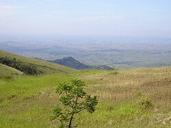
- Serra da Canastra National Park - Known for its numerous waterfalls and for the diversity of fauna that populates it.