Upper Galilee is a region in the northern Israel on the border with Lebanon.

Regional breakdown

The Upper Galilee covers roughly the northern half of Israel's Northern District. It borders on the to the west west galilean North coast, in the south the road 85 forms the approximate border to Lower Galilee. In the east it extends to Lake genezareth, to the Hule valley and to the Golan Heights. In the north the Lebanon the border, there the Galilean mountains continue to the valley of the Litani river.
While most of the Upper Galilee is hilly, the Hule Plain (or Hule Plain) on the eastern edge of the region is flat. The Jordan flows through this plain; it is only just above sea level and thus significantly lower than the highest peaks in the region, which reach over 1000 meters.
places
- The town Safed, also Zefat, is a center of the Jewish Kabbalah.
- The place Rosh Pina was founded in 1882 as one of the oldest Zionist settlements.
- Karmiel is the second largest city in Galilee.
- Kirjat Schmona is located in the Hule Valley near the border with Lebanon; it has repeatedly been the target of attacks in the past.
- Metula is the border location at the currently closed border crossing to Lebanon, worth seeing nature park.
Other goals
background
The mountainous landscape in northern Israel is crossed by rivers, and unlike the rest of the country, there are natural forests here. The limestone cliffs of the mountains are partially covered by black basalt, which comes from the volcanic cones of the Golan. The highest point is that Har Meron At 1208 m, this mountain is also the highest peak in Israel, if you only look at the Israeli heartland (the Hermon on the Israeli-occupied Golan Heights reaches over 2000 meters).
The population in Upper Galilee is very diverse. There are Muslim villages, those populated by Christian Arabs, the Druze religious minority resides here, and there are almost entirely Jewish settlements, especially in the larger towns.
language
getting there
mobility
Tourist Attractions
- The Tel Hazor is one of the biblical settlements that have been a UNESCO World Heritage Site since 2005.
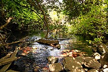
- The nature parks on the source rivers of the Jordan
- the Jordan springs from Banyas with the ruins of Caesarea Philippi
- the nature reserve on Tel Dan east of Kirjat Schmona. The Dan is one of the three source rivers of the Jordan, in the area of the nature park lies the archaeological site of Tel Dan.
- at Metula in the north of Kirjat Schmona lies the Nahal Iyon Reserve
- near Kirjat Schmona also lie the cliffs of Ramim and Manara, the latter can be reached by cable car.
- The HuleValley, in it the rivers unite Banyas, Dan and Hazbani (Senir) to the Jordan. Numerous migratory birds stop in the lakes on their migration.
- The nature reserves around the Mount Meron and the Keziv River.
- The Jewish settlement with the ancient synagogue of Korazim
- The Druze villages are located in the western Upper Galilee Kisra Sumay, Bet Jann and Peki'in.
activities
The Upper Galilee is used for agriculture, the kibbutzim often offer riding holidays, and there are tours with jeeps. The source rivers of the Jordan make kayaking possible. Organized bike tours are offered on the Hule level.
- the lakes of the HulaLevel are used by migratory birds for stopovers and for wintering, bird lovers get their money's worth here.