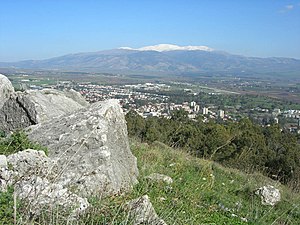
 View of Kirjat Schmona and the Hermon | ||
| Kirjat Schmona, Kiryat Schmona, Kiryat Shmona, Qiryat Shmona | ||
| district | Northern District | |
|---|---|---|
| Residents | 23.076 (2015) | |
| height | 80 m | |
| no tourist info on Wikidata: | ||
| location | ||
| ||
Kirjat Schmona (Hebrew קריית שמונה, "Settlement of Eight“Also transcribed Kiryat Schmona, Kiryat Shmona or Qiryat Shmona) is a city in Upper Galilee in the northern Israel.
Tourists are less interested in the city itself - a modern place with no particular highlights - but rather in the sights in the vicinity, especially the nature reserves at the top Jordan and its sources.
background
Kirjat Shmona is the main town on the Hule Plain, which extends southeast of the city. This plain used to be a large swamp area, which was largely drained in the course of the Jewish repopulation of Palestine in the 20th century. However, parts of the swamps have been preserved and are now an important nature reserve. The plain is crossed by the Jordan in a north-south direction; its source rivers Hasbani, Dan and Banyas unite at the northern end of the plain.
The city itself is of minor importance in terms of tourism. However, Kirjat Schmona is the largest place in this part of the Upper Galilee and an important landmark.
Kirjat Schmona was founded in 1949 as a Jewish refugee camp on the ruins of the Arab village of Khalisa, which its inhabitants had abandoned. The name - "Settlement of Eight" - is reminiscent of the Zionist Joseph Trumpeldor and seven of his comrades, who lived in nearby Tel Chai in 1920 (often also Tel Hai written) were killed in a battle with Arabs. The city achieved a certain (sad) notoriety because in the past it was more often from nearby Lebanon was shot at with Katyusha missiles. The vernacular gave it the name "Kirjat Katyusha", meaning "Katyusha settlement" with clear sarcasm.
getting there
By plane
At Rosh Pina on the southern edge of the Hule plain there is a small airfield (Ben Ya'akow Airport or Rosh Pina Airport), which is not used in regular air traffic. As a rule, you will therefore use the Ben Gurion Airport at Tel Aviv arrive.
By train
The region is not connected to the Israeli rail network; Arrival by public transport can only be made by bus.
By bus
Egged runs daily from the 1 Central Bus Station Bus connections to Haifa, Afula, Tel-Aviv and Jerusalem.
In the street
Kirjat Schmona is just before the northern end of Road 90, which completely crosses Israel and the West Bank from south to north. On this street there are e.g. Eilat in the very south, that Dead sea, Bet She'an (Bet She'an) and the Lake genezareth.
If you come from Jerusalem, one can get the street 1 bis Jericho select and then turn north, from the cities along the coast take one of the main axes to the north (e.g. roads 2, 4 and 6) and then select Hadera or further north one of the main routes to the east.
mobility


In the village one moves on foot in the one on the western ridge Kibbutz Manara can be reached by cable car.
Tourist Attractions

- the 1 Park HaZahavthrough which the river A Zahav runs, with a playground and picnic areas, is quite central in the city.
- the 2 Kiryat Shmona History Museum, Park HaZahav / Ha Yarden St. Tel.: 972-4-6940135. Open: Sun-Thu 8 a.m.-12 p.m.informs about the history of the founding of Kirjat Shmona and the conflicts with Lebanese forces.
- Just a little north of the city lies with Kfar Giladi the 3 Tel Chai Memorial for Joseph Trumpeldor and his comrades.
- the 4 Tel-Hai Museum, Kibbutz Hel-Tai. Tel.: 972-4-6951333. Open: Sun-Thu 9 a.m.-4 p.m., Fri 11 a.m.-1 p.m.informs about the founding of Kibbutz Tel-Hai and the story of Joseph Trumpeldor, who became an Israeli national hero.
- the 5 Tel Hai Museum of Photography, Kibbutz Tel-Hai, Industrial Area. Tel.: 972-4-6816700, Fax: 972-4-6950771. Open: 8 a.m. to 4 p.m., Fri 10 a.m. to 2 p.m., Sat 10 a.m. to 5 p.m.with changing special exhibitions
- Israel's longest cable car, the 2 Manara Cliff Cablecar leads up to the kibbutz Manara (Menara), which was founded in 1943 by German and Polish immigrants and which was visited by Leon Uris to research his novel "Exodus". From Manara, thanks to the altitude of 888 m, there is a great view of the Upper Galilee, but the exposed location was only 100 m away from the Lebanese Border in the context of the conflict over southern Lebanon has already resulted in critical moments.
activities

- Attending a soccer game of the Hapoel Ironi Kiryat Shmona F.C.who has risen rapidly to the top of Israeli club football in the short period of its existence since 2000.
shop
kitchen
- There are numerous catering options in town, especially in the fast food segment.
nightlife
accommodation
- 1 Tel Hai Youth Hostel and Guesthouse, Tel hai. Tel.: 972-2-5945665, Fax: 972-4-6941743, Email: [email protected]., handicapped accessible, WiFi free, ecologically sustainable sanitary facilities
security
health
Practical advice
trips
Nahal Iyon / Nahal Ayoun Nature Reserve (Metula)

runs in the extreme north of the "finger" of Upper Galilee along the brook bed of the Nahal Iyon, which rises a few kilometers north as Ayoun in the Lebanese mountains and carries a lot of water, especially in the winter months. In summer the river is practically dried up due to the large amount of water withdrawn, so winter / spring are the optimal hiking time.
- the 7 Iyon Falls are just south of the Lebanese border, this is where the footpath begins, which takes about an hour and a half to the lower exit of the park.
- the 8 Tahana Falls (Mill Falls) are much higher and more impressive (especially in winter, when the water level is good), the remains of a flour mill can still be seen downstream.
- past the less high 9 HaEshed Falls (Cascade Falls) takes you to the 10 Tanur Falls (Oven Falls), where the water rushes down into two streams divided by a central boulder, two viewpoints allow beautiful views of the waterfall.
- a little further down is the lower one 11 Park entrance with parking lots and picnic area, due to its proximity to the lowest waterfall, the nature park is also called Tanur Reserve designated.
More excursions

- a little south on the cliff above the Hule level is the former British Police Fort 12 Metzudat Koah (Koah Fortress or Yesha Fortress, with a museum), here is also the entrance to the short but impressive 13 Wadi Kedesh, which is under protection as a Nature Reserve.
- South of the city is the Natural parkHula Nature Reserve in the Hule level.
- East of the city are near road 99 with Dan and Banyas the nature reserves at the source rivers of the Jordan, the road then continues on the Golan Heights.
- Located right on the Lebanese border, north of the city Metula (Metulla) with its large sports center.
- If you follow road 90 to the south, you get to the Lake genezareth, at Rosh Pina (Rosh Pina) the road follows Safed from.
literature
Web links
- http://www.k-8.co.il - Official website of Kirjat Shmona