South Tyrolean Waale and Waalwege


A Waal is an artificially man-made irrigation canal that draws water from a stream to distant agricultural crops. Since the rainfall is particularly low in some South Tyrolean areas, agriculture there is dependent on artificial irrigation. For this reason, extensive irrigation systems emerged from the Middle Ages to modern times. Today most of the whales can be found in the Vinschgau and in Burgrave Office.
Waalwege usually do not have a noticeable gradient, apart from the ascent or descent, which is necessary for some to get to the parking lot or public transport.
.JPG/250px-Waalerhüttte_Marlinger_Waalweg_(1).JPG)
Waal paths are accessible at all times of the year, but the waals are drained over the winter and are only flooded again in spring. The Waalwege are among the most popular hiking trails, they attract many hikers and walkers on weekends in spring and autumn, there can be a lot going on and they are accordingly overcrowded. Nevertheless, one should treat other hikers with respect and show consideration for those for whom the flat Waalweg is often the only way to enjoy the mountains and the landscape.
Waaler are the administrators, guardians and custodians of these waterways, for them the paths were created before they were used by tourists. On the Maarlinger Waalweg there is another refuge that shows the barren life of the Waalers in bygone times.
Waalwege sorted in descending order according to length and altitude.
Merano Waalrunde
Length 84 kilometers, difference in altitude: 2880 m, walking time: 7 to 8 day tours
The round begins in Töll and the entire Merano valley basin is circled. The hiking trail is accessible all year round and connects 11 Waalwege. It starts from Töll via the Algunder Waalweg to Dorf Tirol, then to Riffian via the Kuenser Waalweg and further about the Maiser Waalweg and Schenner Waalweg and continue towards Bolzano past Burgstall to Lana Brandiswaal and back to the Töll via the Partschinser Waalweg, Wallburgweg and Rablander Waalweg.
Marlinger Waalweg
![]() Length: 12 kilometers, difference in altitude: approx. 170 m (descent), walking time: 4 to 5 hours plus refreshments
Length: 12 kilometers, difference in altitude: approx. 170 m (descent), walking time: 4 to 5 hours plus refreshments
The Marlinger Waalweg At around 12 km, it is one of the longest Waalwege in South Tyrol. In the 1 Etsch barrage near Töll the Marlinger Waalweg begins, but access is also possible via Marling, Tscherms and Lana. After a short time, the first stop comes, directly on the Waalweg 2 Gasthaus Schönblick with a terrace and a good view of Merano. A few hundred meters further on it says 3 Hotel Residence Aqualis the next stop available. Immediately afterwards you run on 4 Gentian grill and5 Hotel Gasthof Waldschenke past. After a few meters there is the 6 Waalerhütte an impression of the simple life of the Waalers, who had to maintain the Waal and monitor and control the fair distribution of water among the farmers. The next possible resting place is at 7 Waalheim Inn reached. The path meets Lebenbergstrasse, there is one there 8 parking spot directly on the Waalweg, a trip away from the Waalweg is also possible around the 9 Lebenberg Castle (10 minutes easy) to visit, or at 10 Buschenschank Haidenhof (15 minutes one way) to stop off. Follow the Waalweg after a few meters 11 Traudi's snack and shortly afterwards 50 meters off the path of the 12 Eggbauer inn . The next possible stop is this 13 Run pub and after a short stretch of forest you reach the 14 Waal kiosk with souvenirs and other souvenirs. At Oberlana 15 The path ends in Raffeinweg (Via Raffein). The road leads down towards Tscherms. If you go up on the street and go down after 100 m left again you come to the 16 Buschenschank Oberbrunn, a last stop. The steep Aichberg nature trail down leads to the bus station and towards Lana center.
- From 17 Lana bus station Bus 211 leaves every half hour from there to Merano, from the train station you can take bus 212 18 (Stop 4 Novemberstraße, Via IV Novembre) continue to 19 Bus terminus at Forst next to the brewery. On the opposite side of the street, Nörder Straße (Via Tramontana) leads upwards, then following the signs on the right, after a railway underpass, you come to the Marlinger Waalweg and can easily walk back to the bus station in Lana.
.JPG/220px-Marlinger_Waalweg_(9).JPG)
The first stop is already in sight
.JPG/220px-Marlinger_Waalweg_(3).JPG)
good view over the Adige Valley,
.JPG/220px-Marlinger_Waalweg_(6).JPG)
left and right apple trees,
.JPG/220px-Marlinger_Waalweg_(7).JPG)
it can rain even when the sky is blue.
.JPG/220px-Marlinger_Waalweg_(9).JPG)
.JPG/220px-Marlinger_Waalweg_(3).JPG)
.JPG/220px-Marlinger_Waalweg_(6).JPG)
.JPG/220px-Marlinger_Waalweg_(7).JPG)
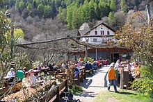
.JPG/220px-Marlinger_Waalweg_Gasthaus_Schönblick_(2).JPG)
Gasthaus Schönblick, right on the way
The Haidenhof tavern is a bit away from the Waalweg

Buschenschank Larchwalderhof, the path leads through the middle

Waalheim Inn
.JPG/220px-Marlinger_Waalweg_Gasthaus_Schönblick_(2).JPG)


Tschars Waalweg
Length: 11 kilometers, difference in altitude: 370 m, walking time: 4 to 5 hours plus refreshments
At 11 kilometers, the Schnalswaal-Tscharser Waalweg is one of the longest whales in South Tyrol and is still used today for irrigation. Construction began in 1505 and was completed after 12 years, and has been in operation ever since. The Waalweg is relatively flat and easy to walk.
- One way to follow marker 3 leads from Neuratheis in Schnalstal via Juval Castle to Tschars. The path takes about three hours to walk, and it is recommended that you reach the starting point in Neuratheis by bus. You can also start this Waalwegrunde in Tschars at the Restaurant Himmelreich.
- Another possibility is to start from Tschars (627 m), height difference approx. 200 m, walking time approx. 3 to 4 hours. Parking is available in Tschars on the parking lot in the curve in front of the town center. Follow the marker 1 A on a farm driveway up to the branching off path 3 and follow this up to the Tscharser Schnalswaal (760 m). Next to the Waal eastwards to the Sonnenhof snack bar (830 m). Here you can make a detour to Juval Castle or the Waalerhütte with the Wahlhammer. Return via paved path no. 1 in the direction of Staben down to the sign to the Himmelreich restaurant. From here on an unmarked but easily accessible path along the Waal back to the end of the Waal and then a few meters to Tschars.

between Juval and Tschars

Hiking trail on the Tscharser Schnalswaal
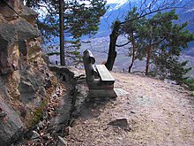
Bench at Tscharser Schnalswaal

Juval Castle


Gschneirer Waalweg
Length: 9 kilometers, difference in altitude: 500 m, walking time: 3 to 4 hours plus refreshments
Forra and Neuwaal - Silandro
Length 9 kilometers, difference in altitude: 220 m, walking time: 2 to 3 hours plus refreshments
Ilswaalweg Kortsch
Length: 9 kilometers, difference in altitude: 130 m, walking time: 2 to 3 hours plus refreshments
Latschander Waal
Length: 8.2 kilometers, difference in altitude: 420 m, walking time: 3 to 4 hours plus refreshments
Leitenwaal - Schluderns
Length: 8 kilometers, difference in altitude: 275 m, walking time: 3 to 4 hours plus refreshments
Maiser Waalweg
Length 8 kilometers, difference in altitude: 270 m, walking time: 2 to 3 hours plus refreshments
From 1 Brunnenplatz in Obermais with parking space to 2 Schloss Planta and on to the 3 Beginning of the Waals on Planta Street (Via Planta) further to 4 Sonnwendhof. Then to the 5 Waalerhaus and on to 6 End of the Maiser Waalweg, refreshment stops in 7 Torgglerhof. The next 8 The bus stop is on the main street in Saltaus. Return by bus, which runs the route between Saltaus and Obermais / Meran several times a day.
Locherer Waalweg
Length 6.5 kilometers, difference in altitude: 430 m, walking time: 3 to 4 hours plus refreshments
Waalweg Schenna
Length 6.5 kilometers, difference in altitude: 420 m, walking time: 2 to 3 hours plus refreshments
Schenner Waalweg
Length 6.5 kilometers, difference in altitude: approx. 100 m ascent, 320 m descent, walking time: 1.5 to 2 hours plus refreshments
The start is in Verdins near Schenna to the Naiftal.
![]() Due to steps and narrow passages, sections are not suitable for prams and wheelchairs.
Due to steps and narrow passages, sections are not suitable for prams and wheelchairs.
Holrinnwaal - Martell Valley
Length: 6 kilometers, difference in altitude:? m, walking time: 2 to 3 hours plus refreshments

Holzrinnenwaal above the Greit farm

Ramini Waal - Tarsch / Latsch
Length 6 kilometers, difference in altitude: 250 m, walking time: 2 hours plus refreshments
Algunder Waalweg
Length 6 kilometers, difference in altitude: 211 m (descent), walking time: 2 to 3 hours plus refreshments
1 You start at a parking lot on the old country road (Strada Veccia) between Töll and Agund. The end of the road is at 2 Reached Gasthof Kirchner.
Riffian Waalweg
Length 5.5 kilometers, difference in altitude: 230 m, walking time: 2 to 3 hours plus refreshments
Today the water is led through a pipeline, the Waal is no longer visible. The starting point is in Riffian on the 1 Bus stop, there are also parking spaces nearby. On the Jaufenstrasse (Via Giovo) it goes to the Hohlgasse (Via Hohlgasse), there up over the Kuenser Waalweg to the 2 Beginning of the Riffianer Waalweg. The path is later referred to as the Rösslsteig Waalweg. 3 At the junction with path no. 5, descend into the village, past and the beautiful 4 Pilgrimage church to Our Lady of Sorrows. The church path with stations of the cross then leads back to the starting point.
Partschinser Waalweg
Length 5 kilometers, difference in altitude: 190 m, walking time: 2 hours plus refreshments
The 1 Waalweg begins about half an hour's walk above the town center of Partschins, from the village center of the marker Legend trail - Waalweg consequences. There are refreshment stops in the 2 Graswegerkeller or im 3 Hotel Gasthof Niedermair. The 4 The end of the Waal is reached in the target valley, then it goes downhill, along the target stream to the suspension bridge, then (path no. 1) back to the village. Since there is a circular route, it is practical to look for a parking space in Partschins.
![]() Due to the steps and narrow spaces, sections are not suitable for prams and wheelchairs.
Due to the steps and narrow spaces, sections are not suitable for prams and wheelchairs.
Zaalwaalweg Kortsch
Length: 4.5 kilometers, difference in altitude: 350 m, walking time: 1 to 2 hours plus refreshments
Plurwaal - Taufers in the Münstertal
Length 4.4 kilometers, difference in altitude: 50 m, walking time: 1 to 1.5 hours plus refreshments
Rablander Waalweg
Length 4.2 kilometers, difference in altitude: 150 m, walking time: 1 to 2 hours plus refreshments
Agumser Bergwaal - Prad
Length 4 kilometers, difference in altitude:? m, walking time: 2 hours plus refreshments
Brandis Waalweg - Lana
![]() Length 3.5 kilometers, difference in altitude: 0 m, walking time: 1 to 2 hours plus refreshments
Length 3.5 kilometers, difference in altitude: 0 m, walking time: 1 to 2 hours plus refreshments
The Brandis Waalweg from Oberlana to Niederlana has a length of 3.5 km. The starting point is 1 Parking lot on Gampenstraße, you go about 500 m up the street, 2 the Waalweg begins on the left. There is no open waterway, the water is transported in an underground pipeline, so the path is so wide that there is no problem for wheelchairs and prams. The path runs without incline between deciduous forest and orchards, past the Lanegg monastery and the chapel of St. Margaret and offers good views of Lana. The path ends in Niederlana on 3 Brandisbach waterfall. The restaurant is ideal for a break Waalrast on whose terrace the path runs. You can either go back the same way, or past old courtyards and other buildings worth seeing via Brandisweg, Schnatterpeckstraße, Kirchweg, St. Margarethenweg, Kapuzinerstraße and the pedestrian zone back. In front of the waterfall, a short circular path with about 200 meters of altitude descends on the right, it leads uphill towards Völlan to the Wetterkreuz 4 . Return via path no. 1 (Niederlana-Völlan) to Waalweg above the South Tyrolean fruit growing museum.
.JPG/220px-Brandis_Waalweg_Lana_(2).JPG)
View of Lana from the Waalweg,
.JPG/220px-Brandis_Waalweg_Lana_(5).JPG)
it leads through chestnut groves
.JPG/220px-Brandis_Waalweg_Lana_(4).JPG)
and orchards,
.JPG/146px-Brandis_Waalweg_Lana_(6).JPG)
past rocks

and ends at the Brandisbach waterfall
.JPG/220px-Brandis_Waalweg_Lana_(2).JPG)
.JPG/220px-Brandis_Waalweg_Lana_(5).JPG)
.JPG/220px-Brandis_Waalweg_Lana_(4).JPG)
.JPG/146px-Brandis_Waalweg_Lana_(6).JPG)

Waalweg Schnalstal
Length: 2.5 kilometers, difference in altitude: 400 m, walking time: 1 to 2 hours plus refreshments
Kuenser Waalweg
Length 2.5 kilometers, difference in altitude: 240 m, walking time: 1 to 2 hours plus refreshments
The starting point is at 5 Gasthof Ungericht, there is also a bus stop. On the asphalted Höfestraße you come to the Mutlechnerhof after approx. 10 minutes, there a marked footpath leads to the 6 Kuenser Waalweg (is also Upper Waalweg designated). It is almost flat and shady up to the 7 Waal catchment at Finelebach, then further over the brook bridge, right down the wide path, after about 10 minutes sharply left, at the brook on the lower Waalweg to the Gasthof Ungericht.
Steinhauser Waalweg
Length 2.5 kilometers, difference in altitude: 200 m, walking time: 2 hours plus refreshments
The starting point is in the center of St. Martin in Passeier
![]() not suitable for prams and wheelchairs.
not suitable for prams and wheelchairs.
Mitterwaal - Glurns
Length: 2.5 kilometers, difference in altitude: 120 m, walking time: 1 to 2 hours plus refreshments
Waalweg Staben
Length 2.5 kilometers, difference in altitude: 40 m, walking time: 1 hour plus refreshments

Hiking trail on the Stabener Waal

At the Stabener Waal

At the Stabener Waal


Verdins Waalweg
Length 2 kilometers, difference in altitude: 0 m, walking time: 1 hour plus refreshments
Oberwaal - Burgeis / Mals
Length 1.5 kilometers, difference in altitude:? m, walking time: 1 hour plus refreshment
Griggwaal - Schluderns
Length 1.5 kilometers, difference in altitude: 75 m, walking time: 0.5 to 1 hours plus refreshments
literature
- : Waalwege in South Tyrol: picture hiking guide through a sinking culture. Tappeiner Verlag, 2010, ISBN 978-8870735246 , P. 140.
- : South Tyrolean Waalwege: A picture book. Athesia, Jul 2010, ISBN 978-8882662943 , P. 216. Reprint.
- : South Tyrolean Waalwege: 40 beautiful hikes. Jun. 2012 (4th edition), ISBN 978-8882668297 , P. 207. Completely revised edition.
Web links
- waalwege.org - Descriptions and maps of the Waalwege
- burggrafenamt.com - Descriptions and maps of the Waalwege in the Burggrafenamt
- meranerland.com - Description of the Waalwege pdf 3.41 MB