The Urft cycle path leads from Blankenheim-Wald over Schleiden-Münd nach Simmerath-Rurberg. It is part of the valley route.
Route profile
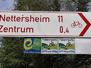
Standard-compliant arrow signpost
- Length: approx. 40 km
- Signposting: conforming to standards Blankenheim forest as "Urft Valley Route"
- Slopes: The route is partly on a slope, hence some inclines, which, however, decrease as the course progresses, from Kall on the route can be described as low-incline.
- Path condition: only partially asphalted, many longer sections with water-bound cover, the path at Urftsee occasionally stony
- Traffic load: Long through-roads, often without a cycle path, country roads rather seldom, traffic-free on the Urftsee
- Suitable bike: Touring bike with gear shift, MTB
- Family suitability: some sections are suitable for school children, e.g. at Urftsee
- Inline suitability No.
background
- The Urft is a 46 km long right tributary of the Rur, so it is quite short. It flows into the Urftsee, which is part of the Rursee. The source is not far from Wald train station.
- The bike route can act as a link between Venn and the Rhine can be seen. However, its poor technical quality does not make this route the preferred route.
- The route is accompanied by the train between Blankenheim and Kall
preparation
getting there
Arriving by train
Blankenheim-Forest
Simmerath-Rurberg
- There is no train connection. Bicycle transport to Heimbach-Schwammenauel is seasonally possible with the Rur boat trip.
Connection to other cycling routes
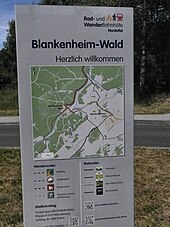
Display board on Bike and hiking station Blankenheim forest
- In Blankenheim (Ahr) begins the Ahr cycle path, the connection from the forest is also signposted as the Ahr cycle path.
- Olef bike path from Gemünd
- RurUfer cycle path from Rurberg
- Bleibach cycle path from Kall
Route description
Blankenheim-Wald - Kall, 17 km

North of Nettersheim
This section is accompanied by the regional train every hour.
- Blankenheim (Ahr)-Wald - The train station is located approx. 4 km west of the town center by the forest. The route runs mainly on a gravel farm road through a quiet valley and accompanies the railway.
- → Connection to the Eifel high route with connection to Ahr cycle path
- Nettersheim (470 m above sea level), rail connection
- Urft, Train stop, after the place there is a larger slope (height approx. 440 m)
- → Detour: Steinfeld Monastery with a basilica from the early 12th century. The monastery offers accommodation and meals. There is a monastery café and also an inexpensive lunch menu. The monastery has an open wifi.
- Sotenich
- Kall, Rail connection, seasonal connection (only Sundays and public holidays between May and November) according to Schleiden-Gemünd (separate tariff)
Kall - Gemünd - Rurberg, 24 km

The path at Urftsee is scenic, but rarely paved
- → Connection to the Olef bike path
- Urftsee
- Dam wall - the dam wall can be passed, there are some beautiful viewpoints and a restaurant. On the other hand, however, there is no bike path. Cyclists should "dismount".
- Obersee
- Dam wall
- Rurberg
Cities
with further information
- Schleiden, National Park in Gemünd