The itinerary on the US West Coast from the Canadian border north of Seattle to the Mexican border San Diego is one of the most popular in the country. The landscape along the Pacific includes steep rocky coasts and sandy beaches. On the U.S. Drive Highway 101 or California State Route 1 directly along the ocean, or - parallel to this - a little further inland through the most important cities of the west coast region. As an alternative to private transport, you can also travel with Amtrak trains or long-distance buses from Greyhound Lines.
background

preparation
getting there
There are major international airports near either end of the route Seattle/ Tacoma and San Diego. If you want to take the northernmost part of the Canadian border with you, you should go to Vancouver arrive. If you only want to travel part of the route, you can go to los Angeles, San Francisco or Portland to fly.
route
The railway lines run along or parallel to the Pacific coast Coast Starlight (Seattle – Portland – Los Angeles), Amtrak Cascades (Vancouver – Seattle – Tacoma – Portland – Eugene) and Pacific Surfliner (San Luis Obispo-Santa Barbara-Los Angeles-San Diego).
With private transport you either follow the very scenic U.S. Highway 101 directly along the Pacific coast or, if you want to go faster, the highway Interstate 5connecting the major cities of the west coast region.
From the Canadian border via Seattle to Portland
- (Vancouver, Canada), this is where the railway line begins Amtrak Cascades
- Everett (Washington)
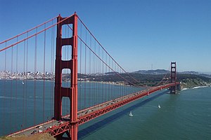
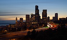
- Seattle, this is where the railway line begins Coast Starlight as well as the Greyhound bus route 601
- Tacoma
- Olympic National Park
- Olympia, State capital of Washington
- Mount Rainier National Park, Mount Rainier, visible from afar, is the highest peak in the Cascade Range at 4,392 meters
- Mount St Helens, active volcano, last erupted in 1980
- Vancouver (Washington)
- Portland, this is where the Greyhound bus route 601 ends and the route 600 begins
Portland to Crescent City
- Salem (Oregon)
- Eugene, this is where the railway line ends Amtrak Cascades; the railway line Coast Starlight leaves the route here and continues inland to Klamath Falls and Sacramento, at Oakland / San Francisco she meets the route again; the Greyhound bus route 600 also leaves the route here and continues inland to Sacramento
- Oregon Dunes National Recreation Area
- Crescent City
From Crescent City on California's north coast to San Francisco

California North Coast: Sequoias and wild stretches of coast.
- Redwood National Park
- Arcata, this is where the Greyhound bus route 607 begins
- Eureka
- Mendocino - known from the hit song of the same name
- Bodega Bay - this is where Alfred Hitchcock shot his film The birds
- Point Reyes National Seashore
- San FranciscoGreyhound bus routes 607 and 540 end here and route 618 begins; the railway line Coast Starlight stops in nearby Oakland
Side trip to Klamath Falls and Sacramento
Instead of directly along the coast, from Eureka you can also go through the inland with the spectacularly scenic Shasta cascades drive. This route is taken by the Coast Starlight-Train and the Greyhound bus route 600:
- Klamath Falls
- Redding
- Sacramento, the Greyhound bus line 600 ends here, the line 540 takes you to San Francisco and thus returns to the main route
- Napa Valley - the most famous wine-growing region in California lies between Sacramento and San Francisco
From San Francisco through the "Middle Kingdom" to San Luis Obispo

California central coast: Fertile and mild, very pleasant climate.
- Santa Cruz
- Watsonville, the railway line Coast Starlight leaves the route here and continues inland through Paso Robles, at San Luis Obispo she meets the route again
- Monterey
- Big Sur, sparsely populated, but very scenic area with no major cities
- San Luis Obispo, this is where the railway line begins Pacific Surfliner, the Coast Starlight meets the route again here
Detour Paso Robles
- Paso Robles - well-known wine-growing area
From San Luis Obispo to Los Angeles
.jpg/220px-Hollywood_Sign_(Zuschnitt).jpg)
- Santa Maria
- Santa Barbara
- Oxnard, the railway lines Coast Starlight and Pacific Surfliner leave the route here and continue inland, near Los Angeles they rejoin the route
- Malibu
- Santa Monica
- Beverly Hills
- Hollywood
- los Angeles, this is where the railway line ends Coast Starlight as well as the Greyhound bus route 618 and the route 676 begins
Channel Islands detour
- Channel Islands in front of Santa Barbara: submarine kelp forests
From Los Angeles via San Diego to the Mexican border
Southern California: Warm and crowded, with Los Angeles and San Diego the largest metropolitan area on the west coast.
- Anaheim
- Disneyland
- Huntington Beach
- San Clemente
- Oceanside
- San Diego, this is where the railway line ends Pacific Surfliner
- (Tijuana, Mexico), this is where the Greyhound bus route 676 ends
security
trips
Beyond the border, you can continue the route on the Canadian or Mexican Pacific coast.