The Archipelago Trail or Archipelago Ring Road (Swedish: Skärgårdens ringväg, Finnish: Saariston rengastie) is a route in the Archipelago Sea in Finland, which uses roads and ferry connections to visit many of the major island in this archipelago.
The archipelago is best experienced by boat, but the Archipelago Trail allows seeing much of it by road. The itinerary passes through the main villages of the western and northern archipelago, while the ferry passages give you some feeling also for the archipelago as seen by boat, with fine views of this unique land of sea and rocky islands. You could also stay for a few days in a cottage by the shore or make detours to minor islands by ferry.
The most convenient means of travel on this route is bike or car, but there are coaches allowing going without vehicle. The tourist bureaus are working on a walking route, partly through the forests, which would offer a quite different experience (a detour to the woods is of course possible regardless). A few of the connections are mainly for tourists; off season completing the route may be difficult, especially by car, but variants are possible all year.
Understand

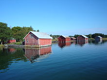
The Archipelago Sea on the south-western coast of Finland is one of the biggest archipelagos in the world, by count of islands and islets. It is a popular area for summer cottages and yacht cruising; the Archipelago Trail allows you to experience some of it without a boat – and without backtracking.
The trail is some 250 km in length (about half with the Rymättylä shortcut), linking many of the main islands of the archipelago via bridges and inter-island ferries. Along the way you will find local food, local history museums and village churches from the Middle Ages as well as comfortable accommodation. You might want to stay a day somewhere by the sea, with a beach and a boat in reach.
The route is usually begun and ended in Turku, although other starting points are possible. The complete route goes from Turku via (clockwise) Kaarina, Pargas, Nagu, Korpo, Houtskär and Iniö to Kustavi in the north and continues back via Taivassalo. The shortcut goes from Nagu to Rymättylä and then via Naantali to Turku.
Most of the archipelago through which the itinerary goes is a Unesco biosphere reserve. The Archipelago National Park lies in the outer archipelago south of this itinerary. The sidetrips by the Utö route from Pernäs, Nagu south route from Kirjais and possibly the transversal route between Kirjais and Pernäs go through the national park and its "interest area". Services such as nature trails, tent sites and campfire places on minor islands on those routes are provided by the national park, while lodging, taxi boats and activities mostly are provided by inhabitants living on private ground in or near the interest area.
Season
The holiday season in Finland is mainly from Midsummer to when schools start in mid-August. Most summer cottages see use also in weekends at least from early May and later in August. This is the best time to visit for most people: the ring road ferry connections from Houtskär to Iniö and from Nagu to Rymättylä are available, like most other services, and the weather is pleasant (2020: ring road ferries from May 15th).
Early spring and late autumn both have their own charm, and winter on an island in the archipelago can be an unforgettable experience. A visit at those times could definitively be worth considering, but this itinerary is written for a visit in season. For off season some of the services are unavailable and there are issues about weather and connections. In winter you might want to stay at some specific site instead of doing the round trip.
The archipelago

See Archipelago Sea for a general description.
Although the itinerary takes you from island to island, you will not be much by the shore, unless you specifically arrange it. The road mostly goes through the interior of the islands, and the ferry quay is not the place to swim or play, nor the most romantic place to watch the seascape.
There are a few official beaches on the itinerary (no guards, but no dangerous currents either – nor at any shore you choose to use), there are some nature trails by the shore, and any cottage will be at the shore, possibly with a rowing boat to get to uninhabited islands (do not land on those with nesting waterfowl). A day at a cottage or a sidetrip to minor islands may be very much worth the extra time.
One reason to come to the archipelago is to enjoy the tranquility, sit at a shore at sunset, watch the flight of terns or swallows, ... These are not the experiences you will get while driving. Do find places where you can just enjoy the silence and the sounds of the wind and birds.
On the itinerary you will be on the main islands, which are much less fragile than the outer archipelago. Here there are no issues with picking wild berries or camping wild. There are quite large woods to explore if you feel like. Normal consideration, as on the mainland, will do very well. Be cautious with fire, though: the climate is dryer and the fire brigade will not arrive as quickly. As on the mainland open fire requires permission, but also cigarette butts, camping stoves and used matches can light a wildfire.
Some of the minor islands have identical names, as they describe not too unusual features or uses. When talking or hearing about e.g. Jurmo, Berghamn or Själö, be sure to note the context (the ones mentioned below are the more well-known, but the others may turn up locally, in timetables or otherwise). It is common to prefix ambiguous names with the former municipality name ("Nagu Berghamn", "Korpo Jurmo").
Prepare

The archipelago communities are well organized; this is not the wilderness but inhabited rural Finland. Thus you should be able to get most of what you need on the route, but opening hours and shopping options are limited. Planning where to eat and sleep and making reservations where appropriate can be wise. Reserve cash, as ATMs are sparse in the archipelago and not all businesses out there take cards.
There are restaurants, cafés and kiosks dotted all over the islands, but as the area is sparsely populated, it is often not useful to try to look for other options once an acceptable restaurant has been found.
Basic spares and repair tools should be brought, so that you can cope with minor breakdowns or flat tyres. On the other hand, people out here are used to handling most situations by themselves, so even severe problems can often be fixed with the help of locals.
Check the ferries between Houtskär and Iniö or between Nagu and Rymättylä. The ones mainly for tourists do not sail off season, and there are only a few passages daily. Off season there are still ferries between Houtskär and Iniö, but these primarily serve the minor islands in the area and the main one does not take cars. With a bigger-than-usual car, such as a caravan, also check capacity on the non-road ferries in season. You may not be able to reserve a slot, but the skipper can give advice on when there should be room.
Check whether there happens to be some kind of festival or other event in some of the villages you pass by: a concert in the church, a jazz festival, the potato festival, a terrain running competition, social dancing, what have you.
It can be chilly at sea and in the evenings. Have a decent coat so that you can admire the seascapes from the ferry decks, even if you otherwise move by car. If you go on a trip with a small boat, you might need real outdoor equipment, including raingear (for the spray), sweater, cap and gloves. Have some quite light long-sleeved clothing for sun protection and possibly warm evenings with mosquitoes. If camping wild, you need some means to carry water for your cooking. Binoculars can come handy to watch birds or archipelago landscapes.
There are weather forecasts for five days, which probably covers your stay. Get one that does not only tell the expected weather, but also explains the general weather type, hinting on how reliable the forecast is.
Renting bikes or a car should be easy in Turku. If you start somewhere else, check availability.
The tourist information offices in Turku and Pargas can be contacted for brochures, books and advice. Preferably use the Pargas one for timetables of the archipelago ferries (there may be quirks unknown to the Turku folks).
- Pargas tourist information (Skärgårdens Turistinformation), Strandvägen 28, ☏ 358 400-117-123, ✉[email protected]. M–W 09:00–16:00, Th 09:00–17:00, F 09:00–15:00.
- Visit Turku, Aurakatu 4 (Centre of Turku next to the City Hall), ☏ 358 2 262-7444, fax: 358 2 262-7679, ✉[email protected]. Sep–Mar M–Su 10:00–15:00; Apr–Sep M–F 8:30–18:00, Sa–Su 10:00–15:00.
Get in

1 Turku is well connected, with some aeroplane connections, daily ferries from the Stockholm region via Åland, trains from Helsinki and Tampere, and coaches from most anywhere in Finland.
You can use (part of) the itinerary when coming from Sweden to Finland: get to Åland and continue with some of the smaller ferries. The leg from Eckerö or Mariehamn to the smaller ferry quays is nice and should be (but is not yet) covered in the Åland article. For a return trip from Helsinki, see also Helsinki itineraries: Archipelago excursion.
Ferries connect Åland with Korpo, Kustavi, Houtskär and Iniö. The main ferries go från 1 Långnäs on the Åland mainland to Galtby in Korpo and from 2 Åva in Brändö to 3 Vuosnainen in Kustavi. The smaller ferries connecting remote islands to Houtskär and Iniö also have services via 4 Torsholma in Brändö, see ferries from Houtskär onward.
Coming from Helsinki you might want to turn out on the Skärgårdsvägen road already in Kaarina, bypassing Turku on the way out (or on the way back, if going counterclockwise). See Turku and Kaarina below.
Coming from the north (or by ferry to Naantali), you could likewise turn towards Kustavi or Rymättylä before reaching Turku. From Uusikaupunki the straightest route to the complete ringroad goes by Lokalahdentie to Taivassalo, to the small ring road by Lokalahdentie and Y-tie via Askainen and Merimasku to Rymättylä, bypassing also Naantali. From Pori you could turn towards Taivassalo or Askainen in Mynämäki.
Go

The route can be taken clockwise or counterclockwise. The former is more common and is what is described here. You could also turn back at any point. Turning back you have to mostly use the same road, but saving some (or most) attractions for the return this is not too bad an option.
Except sidetrips, the Nagu–Rymättylä, or Korpo–Houtskär, Houtskär–Iniö and Iniö–Kustavi legs, and the night, you do not have to worry about ferry timetables; there are usually departures at least every half an hour. You should still note that the ferry passages do take some time.
Do not be afraid to explore the smaller side roads. Often you will end up in the backyard of somebody's summer cottage, but you may also find breathtaking scenery, wild raspberries, a farm selling fresh produce straight from a barn, a tiny picturesque fishing community or many other things. After the ferry to Nagu and until that to Kustavi it is almost impossible to get lost, since there are only a few roads, and all of them will eventually lead either to the sea or to the main road. In a few cases the road will lead through private yards, check your map or ask if it seems you might have reached a dead end and you are uncomfortable just continuing.
By bike
A common way to experience the Archipelago Trail is from the saddle of a bike. The distances are not too great and the bike gives you flexibility while at the same time letting you experience the landscape you are driving through better than by car.
The landscape is rather flat, the roads are in good or decent condition and traffic is mostly light. The main problem is that the road is quite narrow, so where cycleways are missing you might want to get off when batches of cars are approaching, timed by the ferry arrivals. You might want to avoid being on Skärgårdsvägen between Prostvik and Galtby in Friday and Sunday afternoon, as those are the busiest times.
It is possible to take the bikes on the bus (at the driver's discretion), to save time or avoid too hard exercise. Unless you are a big company or you go with the Pargas bus at peak hours, finding room for the bikes is seldom a problem – but get on at the bus station instead of a normal stop when possible, to minimize hassle. The fare for a bike is probably around €5 (depending on company, sometimes on distance).
There are cycleways from Turku to and through Pargas proper. After Kaarina centre until somewhere after Pargas centre the biking route often forks away from the road, as cycleway or on minor local roads (often the former route of Skärgårdsvägen). These points are not clearly marked, but as long as there regularly are cycleway signs (round for cycleways, square for the roads), you are on the right route, except that there are some cycleways also in other directions around Pargas centre. You should not be more than 200 m from Skärgårdsvägen at any point, unless you take sidetrips.
The cycleway is paved until a few kilometres before the ferry to Prostvik. Out in the countryside after Pargas centre it changes character and starts going up and down any hill and bump. After the ferry you have to use the roads, except on shorter stretches through some villages. Good cycleways start again somewhere on the northern mainland.
The variations suggested in By foot below can probably equally well be used by bike.
By car

If you are not fit enough for biking, you are in a hurry or simply like a car better, there is nothing hindering you from using a car. Driving is enjoyable, because of the scenery and the ferry connections between the islands. Remember to stop and step out often enough, to experience the surroundings more intensely.
It is possible to drive through the trail in a day by car, if you start early in the morning, but you should preferably allow two or three days, to be able to relax and actually enjoy what you see, instead of worrying about the next ferry.
You should also not drive out Friday evening or back via Pargas Sunday afternoon, as there then may be very long queues (a few hours at worst), especially at the ferry between Pargas and Nagu, as people from Turku and Helsinki drive to and from their summer cottages. Avoid going in the same direction at those times. And if you happen to be among the first driving off the ferry at peak hours, stop at first opportunity, to let the speeders pass by.
For sidetrips to remote islands, you should mostly leave the car at a parking lot, as capacity on ferries is limited, and there may be no parking nor road to drive at the destination.
Off season the connections between Houtskär and Iniö is served by the "remote island" ferries, some without car capacity. The connection may require staying overnight en route. In winter ferry traffic may be suspended, with connections by hydrocopter or ice road instead.
By bus
From Turku, there are buses every hour or half an hour to Pargas (line 801 and 802) and coaches six to eight times a day to Nagu and Korpo (901–903), once to thrice a day to Houtskär (Näsby; 903) and once or twice daily to Mossala (903–904, mostly with transfer in Galtby, sometimes in Näsby), all these along Skärgårdsvägen and its extensions, the main route of the itinerary. Approximate fares (adult/child 4–11): minimum (6 km) €3.30/1.70, Turku–Pargas €6/3, Turku–Nagu €12/6, Turku–Mossala €20/10. Line 801 uses city bus stops, the 9xx ones (usually with Skärgårdsbuss livery) use coach stops. 801 and 90x alike depart from the bus station until buses move back to Kauppatori (probably 2021). 802 is a rush hour express service.
The routes from Turku are operated by TLO, phone 358 2 274-0333 (M–F 9:00–16:00). In weekends there are also a few coaches from Helsinki directly to Pargas, Nagu and Korpo, not taking short haul passengers, operated by Vainion liikenne (usually with the Skärgårdsvägen Ab livery).
The Pargas bus is used by commuter traffic (from Kaarina and Pargas to Turku), with rush hours in the morning and after work. The Skärgårdsbuss line to Korpo and Houtskär has its peaks when people are going to (or returning from) summer cottages. Mostly there is a transfer for those going to Houtskär: either you change coaches in Galtby ferry harbour or you enter the new coach after disembarking the ferry.
The ring road ferry between Houtskär and Iniö departs from Mossala (17 km from Näsby), with few services (summer 2020: once daily, twice F Su). Another possibility is to use the ferries going from Näsby or Roslax (5 km from Näsby) to remote minor islands – and also to Iniö a few times a week. The most practical solution when the coach does not match is to take a taxi from Näsby to Mossala, which should cost about €30–40.
In Iniö there are no buses. The distance from the ferry quay in Dalen to the main village Norrby is 3 km, which could make for a pleasant stroll. From Norrby to the ferry quay in Kannvik on Jumo the distance is however some 7 km. There is a taxi (☏ 358 50-566-2832).
From the ferry quay in Kustavi (Heponiemi), there are two or three services a day to Turku, and some from Kustavi centre straight along Kustavintie, 6 km away. Check this connection (and the Houtskär–Iniö one) before deciding on your schedule. Operators Taivassalon auto and (from Torsholma) Vainion liikenne.
The shortcut from Nagu Kyrkbacken to Rymättylä (Swedish: Rimito) is not well served with buses. Check connections. You probably have to walk at least a few kilometres, but it is possible you have to use a taxi to get to the Rymättylä parish village.
By taxi
There are taxis available anywhere along the route, but they usually have to come from some distance to fetch you, be prepared to pay for that distance too. Taxi traffic was deregulated from July 2018; taxis are now allowed to set their fees freely. Although most taxis will probably have a price level similar to that before, checking prices when ordering is advisable.
By foot

The ring road can be travelled by foot, and walking can easily be combined with taking the coach on some stretches. By foot you should use minor roads where possible, especially where there is no pavement/bikeway.
If going by foot you should check where to get provisions and whether you need to stock up on food and water. In season there are some summer kiosks and cafés, but outside the main season you are more or less confined to the main villages for staples. Accommodation should not be a problem, if you have a tent or book early. There are toilets on most ferries and at some nature trails and the like, in addition to those at cafés and accommodations. There is a sauna at most accommodations, something you will appreciate after a long day's walk.
The St. Olav Waterway, part of the Nidaros Path pilgrimage, goes from Turku to Korpo and continues via Åland and Sweden to Trondheim in Norway. The path was officially opened on 24 May 2019; the markings are in place and there should be adequate information available. Check where to get your pilgrim's passport.
The St. Olav route can – if you do not want to do the pilgrimage – be used for inspiration to plan your walking route. It deviates from Skärgårdsvägen along smaller roads and uses ferries to go via minor islands. For somebody who is walking long stretches on Skärgårdsvägen the traffic can be intimidating and hinder the experience of tranquillity that is a main point in doing the walk. Taking a break while traffic from the ferry passes helps quite a bit in not getting too disturbed, but using gravel roads by the fields and pathways through the forest is better.
The route follows minor roads or pathways from Turku to Skärgårdsvägen, south of the main roads. It then follows the bikeway, which deviates somewhat from Skärgårdsvägen much of the way to Pargas, where it includes some sightseeing through the town. At Sattmark the route forks to either continue along Skärgårdsvägen or by the small Granviksvägen road and by ferry for accommodation on a small island, either Pensar or Björkholmen (book in advance!), continuing by ferry to Kirjais and returning to the main route on Lillandsvägen in Nagu. The ferries on the alternative route have sparse schedules and might have to be booked the preceding day.
On Nagu Lillandet the route uses Lillandsvägen across the southern part of the island. It is much more quiet than Skärgårdsvägen, although quite a bit longer. Before returning to Skärgårdsvägen it uses some even smaller roads: Laggarnäsvägen, Träskvägen and a tractor track.
From Kyrkbacken on Storlandet the route turns to go along Parkvägen, Norrstrandsvägen (the main road in the north of the island, quite quiet), Sellmovägen and Gallsvägen, a short stretch backwards along Skärgårdsvägen and then Tolkströmsvägen, Mattnäsvägen, Djupdalsvägen and Spinkvägen before again returning to Skärgådsvägen a little before Pärnäs and the ferry to Korpo. On Korpo it follows Skärgårdsvägen.
Turku and Kaarina

Kaarina is part of the Föli bus cooperation, so here you can still get off one bus and on a later one, within two hours from boarding the first. After Kaarina centre there are few buses though, apart from those to Pargas and Korpo, and if you use a Föli ticket you have to get off before the border to Pargas (the Rävsundet bridge; last stop Jullas).
From Turku the main roads are national road 1 (E18, motorway) and regional road 110 (former E18, in Turku and Kaarina: Uudenmaantie) towards Helsinki. Not far outside the Turku city border (2.3–3.4 km depending on route) you should turn towards "Parainen" and "Korppoo" (Finnish for Pargas and Korpo) along Paraistentie (through 2 Kaarina centre), Kaarinantie (from E18) or directly to regional road 180, "the Archipelago road" (Swedish: Skärgårdsvägen, Finnish: Saaristotie). By bike you can also choose minor roads first, but as you hit Skärgårdsvägen, this is the only road for most of the distance. The turn is not well marked at the bikeways; if you went through a tunnel by – not under – road 110 and end up in the countryside, then that was Skärgårdsvägen: take the bikeway along it (you could make the turn earlier and drive through Kaarina centre along Pargasvägen).
After Kaarina centre you will drive over the first small bridge and leave the mainland for the island of Kuusisto (Swedish: Kustö). Here you have the option of a 2×6 km sidetrip to the 1 Kuusisto castle ruins (the bishop's castle was destroyed after the Lutheran reformation, not to offer a stronghold for the Church), the associated mansion (now Kuusiston taidekartano, "Kuusisto art mansion") and the Kuusisto church. Follow Linnanrauniontie ("Castle ruin road"), to the end for the ruins, for 2 km for the church.
On Kuusisto you will soon be out on the countryside. The traffic may still be quite heavy for the road. If you drive a car, take it easy. By bike or bus, just enjoy the landscape.

Kaarina ends with the next bridge (2 Rävsundsbron, Kirjalansalmen silta), which is a sight in itself and also offers the first real archipelago views. The bikeway is a late construction, which had to be compensated by weights on the opposite side of the bridge.
Pargas
Just after the first hilltop you reach the 1 Kirjalan kahvitupa kiosk/café. By bike this is a good place to take a break and an icecream (use your brakes and turn into the tunnel when you continue).
Skärgårdsvägen in Pargas is marked by white cairns, which on one hand symbolize the fairway through the archipelago, which used to be marked by such, on the other hand the limestone (Swedish: kalksten), vital to the town of Pargas.
At the 5 Lielax crossroads you have an option for a longer sidetrip (2×15 km?) to the Qvidja manor on Lemlax, with a medieval keep (privately owned). There is also a local winery (Tammiluoto) on the island.
Just before the next bridge, Hässundsbron, you could turn to Stentorp (2×2 km sidetrip), a sheep farm with very nice handicraft for sale, from yarn and mittens to fur coats and woollen art, and also sheep meat in different forms. Coffee and sandwiches are served in a nice milieu and sheep are available for caressing. At some occasions, and on request for groups, there are sheep herding shows. In spring you may get the chance to bottle feed a lamb.
After the high Hässundet bridge you reach the Kalkvägen roundabout, where the town of Pargas can be thought to begin. Kalkvägen was made of concrete instead of asphalt (hence the name), as a 1970s (?) experiment by the quarry company, but is now a normal road.
The bike route turns to Kalkvägen for a hundred metres, then turns right through residential areas. Turn to the right at the not necessarily obvious Y fork after the hilltop to follow the Archipelago Trail. You join Skärgårdsvägen before the Reimari supermarket, where you could turn left to head for the church and enter the centre that way.
By car you go up and down the hill, pass Reimari (possibly turning towards the church), drive over Kyrksundet by a small bridge and get to the roundabout of Pargas centre (turn left for that sidetrip, right for the S supermarket and the Bläsnäs beach). Close to Reimari you could also turn right for the Solliden camping and the Norrby beach.

3 Pargas is the only town you will see before Naantali. You might want to do some shopping and sightseeing. There are two beaches and a camping site near the roundabout (for 1 Bläsnäs beach, turn right at the roundabout and then continue forward by the right fork, for Norrby and the 1 Solliden camping, turn before the small bridge and the roundabout). If you already had your day's share of biking, camping or lodging here is a good option (probably either at Solliden or at Hotell Kalkstrand). The next lodging will be at Sattmark (9 km farther), unless you are going to camp wild.
Nearly all industry of the town is related to the giant limestone quarry by the centre. There is a museum on the theme and a place with good view of the quarry. Later by Skärgårdsvägen a crossing is marked with giant used part from the factories.
When out on the countryside again, the paved cycleway starts going up and down any bump and hill (luckily none of them very high), but will continue to Lillmälö.
The next bridge is again spectacular, with nice views (but by car you have to be alert not to miss them). You should stop at 2 Sattmarks stuga just after the bridge, a nice café with a shop. There are also cottages and a nature path through the nearby nature reserve of 2 Lenholm.
After Sattmark you will pass many small bridges (bikers join the car traffic at some of them, be careful) and finally reach the first ferry at 6 Lillmälö. On busy times (such as before Midsummer) there will be a queue of several kilometres, which may start without warning after a tight turn. With normal queue length you will see warnings seemingly absurdly early, and there will be a separate lane for the queue (coaches, local taxis and some of the locals have a right of way). Bikers can ignore the queue as you can use space unavailable to the cars – but you could wait for the next ferry if all such space is already used by other bikers. At busy times there are two or three ferries driving non-stop, otherwise they leave mostly every half an hour.

If the queue is long you might want to have an ice cream or coffee at the kiosk. When it is your turn, drive on the ferry carefully, and park the car so that there is as little empty space around it as possible. Put the hand brake on and turn off the engine. After the ferry has departed (but not before) you can go outside to enjoy the scenery (likewise by coach, the door will be opened as you go there). Be sure to return to the car in time so that you will not delay those parked behind you. These ferries are a free public service.
Nagu
The ferry quay is in Prostvik on Nagu Lillandet, the smaller of the main islands of Nagu. The landscape is rural with small villages. Simonby used to have some service. There is a longer road through the south part of the island (using it to avoid Skärgårdsvägen adds quite some distance, but is possible). B&B Västergård is in Gyttja village by this road, as is the fork to Kirjais just south of Lillandet. Kirjais Österby has a ferry quay (12 km from Skärgårdsvägen) for the Nagu southern and transversal routes. If you follow Skärgårdsvägen, you can instead visit the Troolen fish shop with lunch and café (check the map, as the sign is easy to miss).

If you want to see the outer archipelago, you could make a return trip from Kirjais by the "Nagu southern route" (M–Th 9:05→16:00–17:30, Sun 11:00→18:00). By bike, the "transversal route" (M,W,F 15:15) is usable as a means to see some more open waters on the road (get off at Mattby, Krook or Pärnäs on Nagu Storlandet in the evening, you'll then miss Nagu Kyrkbacken unless you backtrack). It is possible to camp with a tent on some of the islands, just check that you will enjoy your stay also after you are done with the sights, as you probably have to stay on a quite small island for a day or two (businesses in the neighbourhood could arrange activities or an earlier return). All these archipelago trips have to be ordered, mostly at latest 16:00 the preceding day, but they are free (no way the real costs could be covered by fees).
The next bridge takes you to Biskopsö (with cottages: Norrgård). Then comes Norrströmsbron with nice views (a stamp with that view, "Moln i skärgården"/"The Sound of Silence", was elected the best of the world 2018). The cycleway starts again just before Nagu Kyrkbacken, the main village of Nagu, on Storlandet. Kyrkbacken is 14 km from Prostvik, 33 km from Pargas centre and 55 km from Turku.
The ferries to Själö, Rymättylä and Norrskata call at Kyrkbacken ("Norra hamnen", i.e. by the main marina).
4 Nagu Kyrkbacken has a 15th century church, a few shops and the biggest guest harbour in the Archipelago Sea (do take a look, it and its surroundings are nice). In summertime there are several accommodation options and restaurants. There is a small museum, with lots of miniatures and paintings telling about the seafaring history of the parish (ships from Nagu have sailed the seven seas, and many locals still work at sea). There are also events in many summer weekends. There is a small beach by the community centre Framnäs, past the harbour.

North of Kyrkbacken is the lush island of 3 Själö (Finnish: Saili), which used to house a lepra hospital, later a psychiatric hospital. Now the Archipelago Research Institute of University of Turku is housed here (with a web camera at an ospray nest). The main sight is the wooden church from 1733, keeping the memories of sad fates. The ferry Östern to Rimito calls at the island, making three return trips daily, Norrskär from Turku makes a trip most days (€8/4 one way). Lodging, restaurant and other services are available since 2017. The half an hour passage is by quite narrow straits between islands, with some views to more open waters. There is also a third ferry, by the "Nagu norra rutt", heading for Houtsala on Norrskata (with road ferry connection to Galtby).
Past Kyrkbacken you can choose the northern, quiet road 7 Norrstrandsvägen (probably signed "Mielis") instead of Skärgårdsvägen (the cycleway changes sides by the crossroads). If you continue by Skärgårdsvägen, watch out for the tight Möviken turn after a kilometre (by car: mind the speed limit).
In any case you will end up in 8 Pärnäs, the next ferry quay, some 12 km from Kyrkbacken by Skärgårdsvägen. Ferries drive across the sound to Korpo, but also to the outer archipelago from another quay (during repaires November 2020–May 2021 from Kyrkbacken). Near the ferry quay is a kiosk, a memorial for the cruise ferry Estonia, which sunk in the Baltic in 1994, with 852 lives lost, and a coast guard station (formerly also the Archipelago VTS).

If you would like to spend a day (and night) in the outer archipelago, this is the main option. Nötö, Jurmo and Utö (about 1.5, 3 and 4.5 hours away; the latter ones belong to Korpo) are popular destinations with lodging facilities, reachable from Pärnäs with m/s Baldur or m/s Kökar (☏ 358 44-500-0503; restaurant on board). In summer (1.6–31.8.2020) departures M–W with return in the evening after ½–3 hr on Utö (no coach connection), Th–Sa with return the next day. Off season (1.9.2020–2.6.2021) departures M W with return the same day, Th–Sa with return next day. Some of the services match the coaches. Parking near the ferry quay. Be on board 10 min before departure. For intermediate ports departures can vary ±15 min, be in time. Calls at some intermediate harbours only as needed ("x" in the timetable) or by advance request ("*" or "y" in the timetable), at all of them off season.
Rymättylä
In season you have the option of a shortcut from Nagu Kyrkbacken via Rymättylä to Naantali (in season: 20.5–4.9), with the shiplike ferry Östern (phone: 358 400-720-606. Three departures daily from Nagu Kyrkbacken (8:40/9:00, 12:10, 15:25/16:20). The one hour ferry trip goes via Själö halfway and continues over Ominaisfjärden, with the main fairway to Sweden and several other fairways (check the maze of navigational aids!), to 9 Hanka (Luotojentie 1091) in Rymättylä. The ferry has a restaurant. Fares: adults €6, children €3, bikes €4, mopeds and motorcycles €8, cars €12, caravans €20, car trailer €24.
There is a bus (line N12) from Ylikylä (some 2 km from the ferry quay) to the main village of 5 Rymättylä (some 12 km away), but it is unclear whether it drives in summer and services are very sparse. The main village has decent (sort of) connections to Naantali. Check unless you are going to use your own vehicle.
[...]
Korpo

You will drive near the northern shore of Korpo, mostly through forest. Most sights come after Galtby, so you may want to make a detour, continuing at least to Kyrkoby. The road from Galtby to Näsby in Houtskär is regional road 1800.
From 10 Galtby ferry harbour there are yellow road ferries to Norrskata and to Kittuis in Houtskär, and a bigger shiplike ferry to Åland. Off peak hours, there are departures to Houtskär about every two hours, with a gap in the traffic 24:00–06:15.
If you come by bus, you probably have to transfer here. Mostly you just get off, board the ferry by foot and get on another bus in Kittuis, but if any of the buses is going to Houtskär you should get your luggage on the bus here. There is a café on board Stella (phone: 358 400-114-291), which might serve breakfast and lunch; the other ferry on the route is Mergus, 358 400-533-461). The passage takes 30–40 minutes, partly by the main fairway towards Sweden. This is one of the passages with good views on what the archipelago is like off the main islands. You may be able to spot a white-tailed eagle or an osprey (there is even a nest on one of the big fixed navigational aids).
By car, follow the procedures from the Prostvik ferry. If there are few cars, you can stop near the middle of the ferry and thus avoid salty spray (some days you get a good share in the front of the ferry). Remember to get out and enjoy the landscape.
6 Kyrkoby is the main village of Korpo, with an old church and a local history museum.
7 Korpoström in the end of the road has a big guest harbour, a shop and the "Archipelago centre" with exhibitions, often also workshops and seminars. There is a restaurant.

Rumar has a nature trail and an observation tower with a 4 weather radar (with an on-site display for the public).
Houtskär
There is a café in the 11 Kittuis ferry harbour, good if you are going towards Turku and have to wait. There is also a camping site with cottages nearby (Kittuis Camping och Caravan), and a guesthouse (Tuulenlatva).
The road will be much narrower here, but locals drive like they knew what is behind any turn (and they do, unless you or an elk happen to be there – keep to the right). There are nice villages, but not much service for tourists. In Träsk there is the Teletalo B&B.

The main village of Houtskär is 8 Näsby, with an old church, two shops with fuel stations, guest harbour (with events some weekends), local museum (nice collection of traditional boats, try to get guiding), ferry quay, accommodation, restaurant etc. Most coaches terminate here.
To get on to 12 Roslax and Mossala you have to backtrack two kilometres. There is a short ferry passage between Roslax and Kivimo and a second between Björkö and Mossala. 9 Björkö is a quite big village. The shop was however closed in 2016, and still searching for a new shopkeeper in 2017.
The ferry quay to get to Iniö by the ring road ferry is in 13 Mossala (17 km from Näsby). There is probably a restaurant and cottage lodging (Mossala island resort). Coaches do not come here every day, except on school days (summer 2018: F Galtby 18:40→Mossala 20:05, Sa Galtby 11:25→Mossala 12:50, Su Näsby 13:50→Mossala 14:25 and Galtby 15:10→Mossala 16:30, back to Galtby Sa 12:50→15:05, Su 14:30→18:10 and 16:35→18:10; those to or from "Galtby" connect with services from Turku, often the bus just waits for the ferry in Kittuis).
m/s Antonia between Mossala in Houtskär and Dalen in Iniö (one hour) looks like a road ferry, but the service is not free. Adults €10, children (4–11) €5, bike €15, moped or motorcycle €25, car €35, caravan €70 (vehicle fares include passengers). Café on board. Departures four times daily June–August and weekends in September (timetable). Vehicles should be ready 10 min before departure.
In addition to the ferry from Mossala, there are ferries going via remote islands a few times a week, intended primarily for locals but available to the public. Taking one of these can be a nice adventure, but you have to check timetables and possible special arrangements. The services mostly have to be ordered at latest the preceding day, and calling the skipper to check details can be a good idea anyway. The relevant routes are those of "Houtskärs ruttområde" (map) and possibly "Iniö tilläggsrutt", by m/s Karoliina (no cars, check whether bikes are accepted; phone: 358 40-717-345) and m/s Satava (phone: 358 40-849-5140).
In summer 2016 there seems to be connections to Norrby on Iniö at least from Näsby Mondays 08:00→10:00 and from Roslax (5 km from Näsby) Wednesdays 17:00→18:30 and Fridays 16:40→18:15.
From Torsholma to Roslax (or Näsby) there are connections (m/s Karoliina) M,W,F 14:40→16:15, Su 13:20→16:45.
Iniö

Iniö used to be the smallest municipality in "mainland" Finland (i.e. except Åland), a group of tiny islands and the surrounding archipelago – 700 km of shoreline – with some 300 inhabitants. Almost every adult had to engage in politics in some way, to fill the chairs. The tradition of doing things together, for the local community, is still strong. Modern times have had some good effects, e.g. 7–9 graders had to go to school in Turku into the 1990s, getting home for weekends, but now have a local school with some lessons handled by Internet video connections to a school on the mainland (the local teachers cannot handle all subjects to a high enough level).
There is a church from 1800 in Norrby and a 3 nature trail in the north-west part of the island, through pine and spruce forest to the highest point Kasberget (40 m), from where you in clear weather can see both Åland and the Finnish mainland, and much of the Iniö archipelago.
There is a lunch restaurant, a camping site and a few lodging options in Norrby and at least a café and cottages in Kannvik. Probably some lodging options also elsewhere.
There are road ferries from the main island to Keistiö and Jumo, while shiplike ferries visit the many remote inhabited tiny islands, mostly on a daily bases. There is a road ferry on the quite long passage to Kustavi.
The ferries from Houtskär use the quays in 14 Dalen (the ring route ferry) and in the main village 10 Norrby (the ferries to remote islands). The ferries to Heponiemi in Kustavi use the quay in 15 Kannvik on Jumo. The distance between Dalen and Norrby is 3 km, from Norrby to Kannvik 7 km.
The ferry Aura (phone: 358 400-320-093) from Kannvik to Heponiemi in Kustavi (half an hour) makes 6–8 trips daily.
Kustavi

The 16 Heponiemi ferry harbour is some 10 km southeast from 11 Kustavi centre, with a wooden church from 1783. Some of the coaches from Heponiemi continue via Kustavi, others have come from Kustavi and continue towards Naantali. If you like to make the detour by coach, check. Vuosnainen (Osnäs), with ferries to Åva in Åland, is some 10 km further south-west from Kustavi, behind a road ferry.
Kustavi is still in the archipelago, with lots of large and small islands, although you will drive over bridges instead of using ferries. [...]
Taivassalo
When you reach Taivassalo, you have left the archipelago. The landscape is still very rural until you get to Naantali or Raisio outside Turku.
On your way to Naantali you will pass through 12 Taivassalo centre. [...]
13 Askainen, Nousiainen and Masku are quite near Kustavintie, which is the straight forward route to Turku. The road goes through Lemu centres to Raisio. You can also go by smaller roads via Askainen, northern Rymättylä and Luonnonmaa to Naantali.
Naantali
Naantali is on the route if coming from Rymättylä towards Turku (the little ringroad), but means more distance if you are coming from Kustavi. Naantali is a town well worth a visit, but whether you have the time to do the town is up to you.
Besides the nice (more or less pedestrian) wooden old town, sights in Naantali include the President's summer residency Kultaranta, the Moomin world and the medieval church. In early to mid June there is a music festival (classical music).
Turku
From Naantali and Raisio there are some motorways that you have to avoid, the other big roads have bikeways. There are many possibilities also to go by minor streets through more interesting surroundings, but a map may be needed to find them.
Stay safe

Going by this trail does not involve any major hazards.
By bike the biggest problem is fast driving cars on the quite narrow roads. Usually the cars are speeding from one ferry to the next, which means they are coming in batches as the ferries arrive. You will mostly be able to hear them in time and wait while they pass.
In the beginning of the route, until the bikeway ends after Pargas, there are tunnels under the main road. In Turku (Uudenmaantie) these can be dangerous because of bikes or mopeds coming out from them, sometimes at high speed (use your bell and your ears). Along Skärgårdsvägen the bikeway is mostly just on one side and you will have to use the tunnels to change sides, sometimes quite unexpectedly (some such crossings are without tunnel, nearly as dangerous if there is traffic).
By car, watch out for elk and deer, especially in the evening. They may stand in the shadow of the wood until deciding to cross the road in front of you, try to look carefully. If you cannot stop, try to pass behind it, as it probably tries to run forward. Report any accident to the 112 even if nobody was hurt, as the animal might be.
If camping or spending time off paved areas, you should be aware of the ticks, which can spread borreliosis and TBE, both potentially nasty. Check your (or your fellow's) body each night to remove them while they are still searching for a good place to bite you, or soon after they have attached (borreliosis gets transferred only after several hours, usually after a day or so, while TBE is still reasonably rare).
If you are unlucky enough to get bitten by an adder, stay calm, avoid motion (rest if possible) and call 112 for instructions. The bite is seldom dangerous for healthy adults, but the person bitten should be put under medical observation.
If you go boating on your own, be aware that the water is quite cold, a lifejacket is appropriate even if you swim well. If unused to boats, take the trip against the wind, to minimize risk of underestimating the distance and wind force. For long trips, take possible weather changes into account (a force 7 wind must be taken seriously also in these sheltered waters; if using forecasts, use those for the sea).
The health care centre in Pargas is open more or less on office hours and those farther out just a few times a week; in nights and weekends you have to go to Turku. With a bit of bad luck the local ambulance is in use elsewhere. Try to be prepared to get along some time on your own (i.e. do not forget your drugs, have spare glasses etc.). There is medical advice available by phone (check the number). There is also a private clinic in Pargas, with a boat and longer hours.
In emergencies the help can arrive by boat or helicopter. A GPS is handy to tell your position (the emergency centre asks for street addresses, as they seldom know minor local landmarks, but coordinates will do). Besides the ambulance, also the border guard, the local volunteer fire departments and the lifeboat associations have personnel trained for medical emergencies (all coordinated by the 112 staff).
Go next
You will probably get on from some of the starting points. See above (and the city/region articles) for connections.
Going on from Turku you might want to check the King's Road eastwards or the Hämeen Härkätie towards Tavastia.