 | |
 | |
| Ardeche department | |
| Capital | Privas |
|---|---|
| Residents | 326.606 (2018) |
| surface | 5,529 km² |
| no tourist info on Wikidata: | |
| location | |
 | |

Ardeche is a department in the French region Auvergne-Rhône-Alpes, Order number 07. It lies west of the Rhône in the south-east of the Massif Central. Ardèche shares a short border with the department in the northeast Isère. It follows in a clockwise direction Drôme, Vaucluse and Gard to the south, Lozère to the west, Haute Loire and Loire in the north-west.
Landscapes and Administration

- The department is the southeastern base of the Massif Central.
- At the Mont Gerbier-du-Jonc (1551 m) in the Monts du Vivarais the originates Loire.
- To the east, the department borders on the valley of the Rhône.
- To the south, the Ardèche drains the country.
3 arrondissements with 33 cantons and 339 communes:
- Tournon-sur-Rhône - 127 066 Ew.
- Privas - 122 255 Ew.
- Largentière - 45 201 Ew.
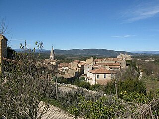
places
- 1 Annonay


 in the Wikidata database") -
- - 2 Aubenas
 -
- - 3 Guilherand-Granges -
- 4 Tournon-sur-Rhône -
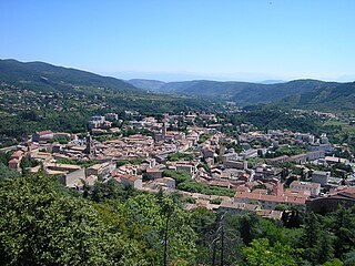
- 5 Privas - is the prefecture (administrative seat) of the department
- 6 Le part -
- 7 Bourg-Saint-Andéol -
- 8 Saint-Péray -
- 9 Vallon-Pont-d'Arc -
- 10 Labastide-de-Virac -


background
language
French. English is also spoken in the tourist environment (hotels, restaurants, boat rentals). German language skills are available in the younger population, but are rarely used.
getting there
Via the autobahn A7 - Autoroute du Soleil of Lyon out towards the south. The eastern border of the department lies directly along the Rhône and the A7. About 60 km south of Lyon is the northernmost tip of the department. Motorway exit number 12, "Chanas". The southernmost corner of the department can be reached from the ![]() 19 Bollène out. This is also where the mouth of the river is located Ardeche, who gave the department its name, to the Rhône.
19 Bollène out. This is also where the mouth of the river is located Ardeche, who gave the department its name, to the Rhône.
over Pont-Saint-Esprit can be reached over the bridge and at St. Martin d'Ardèche on the left bank D290running along the gorge of the Gorges de l’Ardèche leading Route touristique.
mobility
Buses run along the Ardèche gorges, you are more flexible with your own motor vehicle and can easily make photo stops at the viewpoints ("Belvédères"). Cycling is challenging with the up and down and heavy traffic in summer.
Tourist Attractions
- PN des Cévennes - Cevennes National Park (Parc national des Cevennes) is in the south-east of France Massif Central. The cave explorer Edouard Alfred Martel proposed the creation of a national park for the Cevennes as early as 1913, and in 1970 this became a reality. There are mountains in the 321,300 hectare park (Mont Lozère, Mont Aigoual) and high plateaus (Causse Méjean) and a very varied and species-rich flora (Sundew, Tulips, lavender, Orchids, Chestnuts) and fauna (Mouflon, Ibex, Deer, stags, beaver, Gorse cats, Horseshoe bats, Woodpeckers).
- PNR des monts d'Ardèche - Monts d'Ardèche Regional Natural Park (Regional Natural Park of the Monts d'Ardèche) The 180,000 hectare nature park was founded in 2001 and lies between Lamastre and Les Vans. It includes the landscapes of the Boutières, the Vernoux Plateau, the Sucs, the top Cevennes, the Cévenne Méridonale and the Piedmont Cévenole.
- Chemin de fer du Vivarais - A museum railway between Tournon-sur-Rhône through the imposing Doux canyon to Lamastre. Steam locomotives and diesel railcars operate. The route is 33 km long and the journey takes a maximum of 2 hours. It is possible between April and October.
- Chauvet grotto - UNESCO World Heritage Site. Discovered in 1994 near the Pont d'Arc, also known as the Sistine Chapel of the Stone Age. The grotto itself is not open to the public. In Vallon you can see the paintings in a small museum and a 1: 1 replica of the cave.
- Gorges de l'Ardèche - The approx. 30 km long gorge with the 60 meter high rock arch Pont d'Arc, the symbol of the department, is very worth seeing. The gorge can be viewed from the road at various viewpoints or from the water. The gorge is also accessible on foot for hikers.
- Mont Gerbier-de-Jonc - ...
- Aven d'Orgnac - A spectacular stalactite cave near the village of Orgnac-l'Aven. The cave is in contention for inclusion in the UNESCO World Heritage Site. The cave is called Aven because the natural entrance is perpendicular down from the surface of the earth. Visitors can comfortably reach the huge halls and bizarre stalactites of the cave via an elevator. Speleology excursions are also offered, which, under the guidance of a guide, show the participants areas of the cave that are not open to the general public. The excursions stretch over several hours, and sometimes even rope climbing is required.
- Annonay - ...
- Cruas - ...
- Privas - ...
- Tournon-sur-Rhône - ...
- Vallon-Pont-d'Arc - One of the tourist centers in the Ardèche region. There are numerous boutiques, bars and restaurants. Vallon mainly attracts young audiences. This is also the starting point for excursions such as canoe and kayak tours, canyoning and rafting or MTB tours. The famous Pont d'Arc, the symbol of the Ardèche, is located a few kilometers downstream near the village.
- Vals-les-Bains - ...
- Villeneuve-de-Berg - ...
- Viviers - ...
activities
- Canoe or kayak through the Gorges de l'Ardèche. There are also boat rental companies on site, so you don't necessarily have to bring your own boat. The rental companies will pick you up at the agreed meeting point at the end of the Petite Descante or at the end of the 30 km tour in Sauze. It is easily possible to drive through the gorge in one day (approx. 30 km). You can also extend the tour to 2 days and spend the night in the designated bivouacs. It is important to bring enough water, food, and sunscreen, as well as suitable clothing. Sturdy shoes (sneakers or water sports shoes) are important, slippers are easily washed away and do not give the foot any support.
- Hiking: There is a hiking trail through it Gorges de l'Ardèche on alternating sides, you have to cross the Ardèche at least four times (Gué on the IGN card stands for a ford that usually has to be waded through) or ask a boat driver to translate one. The GR4 runs along the Ardèche.
- Numerous stalactite caves invite you to visit.
- Riding: you can go to numerous locations such as B. Rent horses in Vallon-Pont-d'Arc to explore the area.
- Cycling (MTB or road): the Ardèche is an Eldorado for cyclists.
- High ropes and climbing gardens: in the forests and on the rocks of the Ardèche there are numerous opportunities to experience guided or unguided climbing tours.
- Swimming: you can swim very well in the rivers of the Ardèche (Ardèche, Chassezac, Beaume). The water is relatively clean. The impressions of nature are breathtaking. Open fires and barbecues are forbidden at least in the summer months, if only because of the fire hazard.
kitchen
- agneau pascale - Easter Lamb
- brassadeau - Cookies
- caillé doux de Saint-Félicien - Cream cheese made from cow's milk
- caillette - Minced meat balls with bacon, liver and chard in a pork net
- châtaigne - chestnuts
- chevreau - goat meat
- jambon sec d'Ardèche - air-dried ham
- marron ice cream - glazed chestnuts
- miel - honey
- oignon de Tournon - Tournon onion
- pantin d'Annonay - Cake
- pêche de l'Eyrieux - Eyrieux peaches
- picodon de Dieulefit (AOC and AOP) - cheese with fresh dough made from raw goat's milk
- pouytrolle - Vegetable dish made from herbs and spinach
- Chèvre Chaud - Grilled goat cheese on a bed of lettuce, usually together with toasted white bread slices, sometimes in a puff pastry coating, enriched with honey and walnuts.
- tapenade - Paste made from olives, olive oil or sundried tomatoes. Tapenade is available in green, black and red, depending on the ingredients.
- Wine has been grown in the area for 2000 years, and today it is named after the region Coteaux de l'Ardèche called.
nightlife
There are numerous bars and restaurants in Vallon-Pont-d'Arc.
security
In the Gorges de l'Ardèche tidal waves can occur after rainfall, you should always inquire about the weather before activities in the gorge.
climate
Continental with a tendency to thunderstorms in summer due to the mountainous location. Especially cool nights in winter.
trips
- for canoeists to the Gorges-du-Gardon
literature
- : The wild mountains of the Ardèche: travel and hiking guides around the Massif du Tanargue in the Cevennes. Uli Frings, Jun. 2017 (5th revised), ISBN 978-3000257513 ; 100 pages. 22 hiking tours described in detail with a good detailed map
- : Ardeche and Cevennes. Paths through an old cultural landscape in southern France. Schiler publishing house, March 2004 (4th, revised A.), ISBN 978-3899301649 ; 301 pages.
- Charles-Henri de Bossieu, Yves Garnier, Philippe Lacrouts (Ed.): Atlas départemental de la France. Larousse, 2004, ISBN 2-03-505448-6 ; 288 pages.
Web links
- ardecheinfo.de - Information on the Ardeche region
- Vallon-Pont-d'Arc - Information about Vallon Pont d'Arc on the Ardèche
- Chauvet grotto
- Aven d'Orgnac stalactite cave