
Who is in Kuala Lumpur and the surrounding Klang Valley there are a number of possibilities for excursions. The selection is extremely diverse. Starting with the urban highlights of the actual Klang Valley, rainforest in KL's north to the amusement parks of Sunway Lagoon and Genting Highlands. There is something for everyone.
Forest Research Institute of Malaysia
| Distance: 16km northwest Time: Half or full day |
This is located northwest of Kuala Lumpur Forest Research Institute of Malaysia, an area with real, dense tropical rainforest. Exhibitions, hikes and a canopy walk (suspension bridge between the large trees) invite you to explore. A recommendation for a tour is shown on the dynamic map. The visit can be easily combined with the Batu Caves - and, if you ever sit in a taxi, maybe even with that zoo.
Where the Klang Valley stands today, there used to be dense jungle - one of the oldest tropical rainforests in the world. If you still want to see a little lush rainforest but don't want to travel far, this is the right place on the northwestern edge of the capital area. The Forest Research Institute of Malaysia is one of the oldest forest research institutes in the world. It was opened in 1929. The forest on the 600 hectare research site is not a primary rainforest, but has been untouched for 60 years. The best times to visit are of course the early morning and late evening, when the jungle is really alive - audible and visible.
- 1 FRIM Information Center. Tel.: 60 (0)3-62797525. there you can get advice and information about your visit, book a guided tour and pay for the canopy walk. If it is closed, the card will help.Open: daily: 9 a.m. - 4 p.m.
- The 1 Canopy Walk - a suspension bridge system made of ladders and ropes - was built for the researchers to study flora and fauna in the upper floors of the tall rainforest trees. The 200m long suspension bridges are anchored to five tall trees and are about 30 meters above the ground. As you walk across the bridges, you will be rewarded with views of the tree tops and beautiful views of the Kuala Lumpur skyline. Registration for the walk across the bridges ends at 1 p.m. It is open Tuesday to Thursday and on the weekend from 9:30 a.m. to 2:30 p.m. It's at the top of the hill 2 Bukit Nolang and can be reached via the hiking trail 3 Rover Track. If you continue on the hiking trail after the Canopy Walk, you will come to a small waterfall, the 4 Sungai Kroh
- The rainforest can be explored nicely on a circular hiking trail. Besides the above Rover Track, which leads around the site, there is still the 5 Salleh's Trail, an extension at the beginning of the rover track. The start is at the pond at the museum. The 6 Keruing Trail is a little way to the east by the museum and cafeteria.
- There are a few on the site Arboretums to explore. This is located in Jalan Symington at the end of the large circular path 7 Dipterocarp Arboretum With Wing fruit plants and the 8 Non-Dipterocarp Arboretum. The former is home to some of the oldest and rarest trees in the country. This family of trees makes up about three-quarters of the Malaysian rainforest. There is that south of the information center 9 Monocot Arboretum (Monocot Center) and that 10 Coniferatum. Finally, there are two areas with fruit trees: 11 Fruit Tree Arboretum I. and 12 Fruit Tree Arboretum II. They are joining them 13 Cryto-gamic Garden and 14 Ethno-botanical garden
- Opposite the Information Center there is a
- 15 museum. Open: daily 9 am-4pm.
- There is one across the street for food
- 1 cafeteria, Jalan Foxworthy. Open: daily: 9 am-7pm.
- 2 Sungai Kroh Picnic Area (At the end of the site near the waterfall). Camping is possible on the site, but must be registered in the information center.
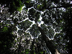
Rainforest giants
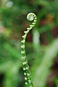
young plant

mushroom
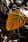
lonely leaf
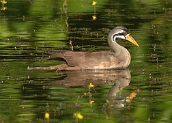
Rush rail

Canopy Walk
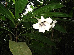
Rothmannia macrophylla


Kuala Selangor
| Distance: 67km northwest Time: All day / overnight |
.jpg/220px-Bagan_Pasir_@_Kuala_Selangor_(5975221780).jpg)
Kuala Selangor is a city in the Malaysian province Selangor. The comparatively small town is located away from the usual tourist flows at the mouth of the Selangor River and therefore has a very rural flair. It is mainly visited to observe the fireflies in the area - but mainly in the form of Excursions from Kuala Lumpur out. There is also an old British fortress on top of it Bukit Melawati as well as the Kuala Selangor Nature Park right by the sea with mangroves, monkeys and birds. Here a walk invites you to explore. The city is easy to visit as a day trip. Those who see the fireflies and don't want to rush back to Kuala Lumpur immediately afterwards can also spend the night and spread the sights over the afternoon of the first day and the morning of the second day.
The exploration starts at Bukit Melawati with the
- 16 Fort Altingberg. Open: 09: 00-16: 30.Price: free entry.
Parking spaces and the bus station are nearby. In addition to the fort, there is also an old lighthouse, cannons, a lookout point and a clock tower. It goes on to the sea and the
- 17 Kuala Selangor Natural Park. Open: daily 09: 00-17: 30.
with a mangrove area and forest strips of 324 hectares, in which 150 bird species live alone. It's easy to explore on foot. The longest route is 1.5 kilometers. Back in the town center you can have a refreshment. Those who are interested can still see the work of the nationwide known 18 Tombstone Maker look at. A car is required for the next stage. You grab a taxi and visit (preferably by prior arrangement) the
- 1 V.N. Ramada's Pottery. Tel.: 60 (0)3-32891054. This is one of the most famous and largest Indian pottery factories in the region. Here are around pots of your own brand man panai on a special potter's wheel called pugmillim jolly jongels produced.
At dusk it is time for dinner in one of the restaurants in
- 3 Pasir Penambang
- Now it goes to the fireflies. Start is in 1 Bukit Belimbing or 2 Kampung Kuantan. You can take a boat along the river bank and watch the blinking in the vegetation. Details about the sights and possibilities for accommodation and food are in place Kuala Selangor described and listed in more detail.
Kuala Kubu Bharu
| Distance: 72km north Time: Whole day |

Kuala Kubu Bharu is the capital of the Hulu Selangor district in northeast Selangor. The small, sleepy place with its charming surroundings offers some opportunities for hiking and sporting activities. It is therefore an ideal destination for excursions from Kuala Lumpur from as well as a stopover on the journey to Fraser’s Hill at. The journey can be made with the KTM Komuter, a car / taxi or as part of a guided tour.
The exploration starts in the tranquil town center. Here you can fortify yourself for the following tour in one of the restaurants. 2-3 kilometers east of the village is the 19 Sungai Selangor Dam. This is the third version of the dam; its predecessor was breached by the river in 1883 and 1926, which also flooded the original Kuala Kubu Bharu. The local Temuan believe that the spirit of a red dragon is to blame for the two breakthroughs. The dam and reservoir serve as a water reservoir for Kuala Lumpur and parts of Selangor. A little further up the sea is that 20 Dam Information Center. It also houses an exhibition on the history of the dam project. It also offers a good view of the overflow weir for the rainy season. Two indigenous Orang Asli communities were also affected by the dam project. They belong to the Temuan population group. Their villages were not relocated without protest. One of the new villages 1 Kampung Gerachi Jaya, is located west of the lake not far from the dam. However, the modern village architecture does not correspond to the original way of life. If you want to visit the village, you can ask the village chief Tok Batin to have a look around the village. So you can still catch some of the traditional culture. Gifts in the form of rice, tea or coffee are welcome. The second village2 Kampung Pertak, is located three kilometers further up the sea on the banks of the Sungai Luit, a tributary of the Sungai Selangor. A walk along the small river is ideal here. If you ask for permission, you can also explore the village more closely. * Kuala Kubu is one of the most popular places for Bharu White water sports. The Selangor River and its tributaries are ideal for canoeing, kayaking, rafting and tubing. Normally you won't have your own sportswear with you. Here you can best contact some of the local agencies in KBB itself or in Kuala Lumpurwho offer organized half-day and full-day tours - also in connection with hikes in the rainforest. Another starting point for water sports is at the 21 Rainbow Bridge further above the lake. Occasionally, athletes use the bridge to abseil. At the Rainbow Bridge there is a path for hiking. The 1.5-hour hiking route leads along the Sungai Chiling to the three-tier, 50-meter-high 22 Chiling waterfall![]()
![]() . However, the river has to be crossed six times - a tour that you shouldn't do alone, but rather in a group tour. A picnic on the stones and a swim in the river will top off the hike.
. However, the river has to be crossed six times - a tour that you shouldn't do alone, but rather in a group tour. A picnic on the stones and a swim in the river will top off the hike.

Kuala Gandah
| Distance: 120km northeast Time: Whole day |
_and_other_tourists_help_bathe_two_Asian_elephants.jpg/220px-thumbnail.jpg)
The excursion leads to Kuala Gandah, 120 kilometers northeast of Kuala Lumpur. Stops are a protected forest area, a visit to the elephants of Kuala Gandah and the home of the local Che’Wong minority. It is advisable to take a car for the excursion. Taxis take around RM 250 for the round trip. You can hire them at the Puduraya Outstaion (Tel .: 03-20783525). Even the journey on the Karak Highway (toll) is very scenic.
The first stop is 30 kilometers after the Gombak toll booth. At 48 kilometers, turn left to the 23 Lentang Forest Recreational ParkHutan Lipur Lentang,Hutan Lipur Lentang
- Forest Department. Tel.: 60 90-2330484. Here you can get some information. You should also register if you go on longer hikes. The river in particular can suddenly rise after the rainy season. The area is ideal for a little relaxation and a picnic. You should bring food with you.Open: Mon-Fri: 8 a.m.-5 p.m., Sat-Sun: 10 a.m.-5 p.m.
- bistro. Opportunity to get food.Open: daily: 8 a.m. to 5 p.m.
The area can be quite crowded on weekends.
Now it's 50 kilometers on the highway to the Lanchang exit. To the left of the highway (in a northerly direction) you will reach the village after a few kilometers 3 Kampung Kuala Ganlah with raised houses. This is home to the local Che’Wong minority. On the right side next to the street there is a triangular building - the
- Handicraft Center. Open: daily: 10: 00-13: 00..
- The village, which shows typical Che’Wong architecture, is easy to explore on foot. The community's economy is still heavily dependent on forestry.
South of the descent is the place Lanchang and that - 24 Kuala Gandah Elephant Conservation Center. Tel.: 60(0)9-2790931. There is a small cafe. The program starts at around 1 p.m. with a video presentation. The center's elephants are used to interacting with people. You can bathe them, feed them and ride them. Elephants live in the center and had to be relocated, e.g. if their original habitat was taken over.Open: Sun-Thu: 8 a.m. - 4:45 p.m.; Fri: 08: 00-12: 30, 14: 45-17: 00.Price: Admission: A voluntary donation.
Fraser’s Hill
| Distance: 114km north Time: Whole day |

Fraser’s Hill(Bukit Fraser) is located at an altitude of 1,500 meters in the mountains in the center of the Malaysian peninsula. The first British hill station in Malaysia during colonial times offers breathtaking views, highland weather and colonial architecture. The average daytime temperatures of around 20 ° C invite you to escape from the heat of the lowlands. The place is named after the Scotsman Louis James Fraser, gold prospector in Australia, who eventually mined tin on the Malaysian peninsula. He hired Chinese workers for the hard work and to maximize his profits he also set up opium and gambling dens, possibly a reason for his mysterious disappearance. The tin mining ended in 1913 but the resort at 1524 meters above sea level with its pleasant temperatures continued to enjoy great popularity. In 1922 a road was built through the mountains to Fraser’s Hill. Soon bungalows and even one of the first golf courses in Malaysia were built. Since then, the place has not changed much and still exudes its cultural and colonial mixture. Locals eat curries made from banana leaves in an English cottage next to the golf course while the call to prayer echoes from the mosque next door. It is worth seeing 25 Clock tower![]()
![]() very British looking wine-entwined stone clock tower. It was designed by the Malaysian landscape architect Z.Jaal and built by the Frasers Hill Development Corporation in 1989. The 26 Jeriau Waterfalls, is 5 kilometers from the city center and then a 5-minute walk is 6 meters high and falls into a shallow pool, which is suitable for swimming. A picnic area and toilets are also available. Bird watching is also possible at the waterfall. Danger! After rain, the footpath to the waterfall is quite slippery. The place can get quite crowded on the weekends. The hiking trails, however, make it possible to escape the crowds a little. There are a total of eight marked hiking trails around the place. Some may still be banned due to a past incident that was publicized. In 2005 three boys got lost in the jungle looking for lychees. The Hemmant Trail offers a small circular route in the center to explore the place. If you want to keep walking, you can still do that Bishop's Trail append. Other hiking trails require a guide and also more stamina. Fraser’s Hill is a world famous bird watching hotspot. Over 250 species have been recorded here so far. The winners of the annual June event Bird Race registered up to 70 species in one day. During the competition, migratory birds also pass this place in transit. A short and narrow nine-hole course set in an old tin mine. The place is public. Golf equipment can be borrowed from the Sports Complex.
very British looking wine-entwined stone clock tower. It was designed by the Malaysian landscape architect Z.Jaal and built by the Frasers Hill Development Corporation in 1989. The 26 Jeriau Waterfalls, is 5 kilometers from the city center and then a 5-minute walk is 6 meters high and falls into a shallow pool, which is suitable for swimming. A picnic area and toilets are also available. Bird watching is also possible at the waterfall. Danger! After rain, the footpath to the waterfall is quite slippery. The place can get quite crowded on the weekends. The hiking trails, however, make it possible to escape the crowds a little. There are a total of eight marked hiking trails around the place. Some may still be banned due to a past incident that was publicized. In 2005 three boys got lost in the jungle looking for lychees. The Hemmant Trail offers a small circular route in the center to explore the place. If you want to keep walking, you can still do that Bishop's Trail append. Other hiking trails require a guide and also more stamina. Fraser’s Hill is a world famous bird watching hotspot. Over 250 species have been recorded here so far. The winners of the annual June event Bird Race registered up to 70 species in one day. During the competition, migratory birds also pass this place in transit. A short and narrow nine-hole course set in an old tin mine. The place is public. Golf equipment can be borrowed from the Sports Complex.

Genting Highlands
| Distance: 51km northeast Time: Whole day |

Genting Highlands(Tanah Tinggi Genting) is a mountain with a well-known resort and amusement park about 50 kilometers northeast of Kuala Lumpur near the state border Selangor and Pahang - and the only place in Malaysia where you can officially gamble. The resort with the amusement park offers itself as a Day trip from Kuala Lumpur off on. If you want, you can of course check into one of the large hotels and enjoy the many attractions on offer.
The Genting Skyway takes you up the mountain. The Genting Skyway is the newer cabin cable car, inaugurated in 1997, on the way up to the hotels and amusement parks on the summit. Until then, there was only the somewhat secluded Awana Skyway. In its early days, it was Asia's longest and fastest cable car. The 3.38 kilometer long cable car overcomes a difference in altitude of 900 meters. The ride in one of the 100 gondolas, which travel at 21.6 kilometers per hour, takes 11 minutes. The 54 millimeter thick suspension cable rests on a total of 22 supports. The cable car usually runs from 7:30 a.m. to 11:00 p.m. If you want, you can also walk a bit. After taking the cable car up, you can explore the parks at the top and take a stroll down the street to the top 27 Chin Swee Caves Temple do. The older cable car, the Awana Skyway, also stops at the temple and can be used to return to the summit or down.

There are three amusement parks on the mountain: 1 Genting Outdoor Theme Park, 2 First World Indoor Theme Park, 3 Genting Indoor Theme Park and the water park.
If you want to stay overnight you can choose from 5 hotels on and more on and next to the mountain. The First World Hotel alone has over 6,000 beds. Some other smaller sights can be found on the mountain. If you want to visit Genting Highlands comfortably as a day trip from Kuala Lumpur or the Klang Valley and do not travel with your own vehicle, you can use one of the convenient all-inclusive offers (admission, bus and cable car ride). Price approx. RM 47.00. More detailed information is available at Genting Highlands
Putrajaya
| Distance: 25km south Time: Half or full day |
Putrajaya is the administrative center of Malaysia and is an independent federal territory. It is 30 kilometers south of Kuala Lumpur and is well worth a visit. The city looks like it has been peeled from an egg; no wonder - it's a planned city after all. It is very spacious and nicely laid out. The districts are criss-crossed and surrounded by nice artificial lakes and waterways. The place was named after the country's first prime minister Tunku Abdul Rahman Putra named and is the new administrative center of Malaysia. Local transport.
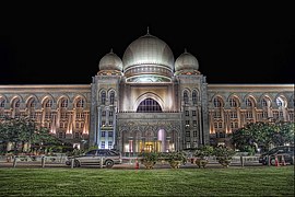
Central part of Putrajaya is Precinct 1that can be easily explored with a walk. The district is located on a hill on and around which government buildings are located. The steel sculpture stands on the mountain Mercu Tanda. Start is at the Putra Bridge, immediately to the left you can see the large, striking one 28 Putra Mosque (Masjid Putra). At 116 meters, the minaret is the highest in Southeast Asia. Construction of the mosque began in 1997 and ended two years later. The design represents Persian-Islamic architecture from the 16th to 18th centuries. In the extension of the bridge you can see the Prime Minister's seat 29 Perdana Putra![]()
![]()
![]() . The building was built between 1997 and 1999. It was designed by the architect Ahmad Rozi Abd Wahab and shows Malay, Islamic and European influences. Behind it is the hill with the park 30 Taman Putra Perdana. This beautifully landscaped park pulls away Perdana Putra to the hotel Shangri-La. Beautiful paths and views make the park worthwhile. In the middle of the park it says 31 Mercu Tanda (Putrajaya Landmark)
. The building was built between 1997 and 1999. It was designed by the architect Ahmad Rozi Abd Wahab and shows Malay, Islamic and European influences. Behind it is the hill with the park 30 Taman Putra Perdana. This beautifully landscaped park pulls away Perdana Putra to the hotel Shangri-La. Beautiful paths and views make the park worthwhile. In the middle of the park it says 31 Mercu Tanda (Putrajaya Landmark)![]()
![]()
![]() . It is a steel sculpture which symbolizes the beginnings of the city of Putrajaya and contains a time capsule. The design represents a mix of high-tech as well as contemporary and traditional motifs. The monument is surrounded by pavilions and fountains. Further to the northwest you can reach the 32 Taman Botani (Botanical Garden). The Moroccan pavilion shows some architectural finds from four Moroccan cities. There is also a sun garden with a sundial.
. It is a steel sculpture which symbolizes the beginnings of the city of Putrajaya and contains a time capsule. The design represents a mix of high-tech as well as contemporary and traditional motifs. The monument is surrounded by pavilions and fountains. Further to the northwest you can reach the 32 Taman Botani (Botanical Garden). The Moroccan pavilion shows some architectural finds from four Moroccan cities. There is also a sun garden with a sundial.


- 4 Putrajaya Seafood Restaurant
- 5 Selera Putra. Finally, you can have something to eat at the lake below the Putra mosque.
If you want to explore the city further, you can take the walk south to the 33 Putrajaya International Convention Center![]()
![]()
![]() expand. It can be seen from afar at the end of the boulevard. The event center (PICC for short) was built from 2001 to September 2003. It stands on a hill and looks like a monument. It was designed by Malaysia's fourth Prime Minister Tun Dr. Mahathir Bin Mohamad. The area of the entire PICC area is 135,000 m². It has a total of 10,000 people in over 50 halls and rooms.
expand. It can be seen from afar at the end of the boulevard. The event center (PICC for short) was built from 2001 to September 2003. It stands on a hill and looks like a monument. It was designed by Malaysia's fourth Prime Minister Tun Dr. Mahathir Bin Mohamad. The area of the entire PICC area is 135,000 m². It has a total of 10,000 people in over 50 halls and rooms.


Perdana Putra

Putra Mosque and Perdana Putra

Residential houses in Putrajaya

Putrajaya International Convention Center
Palace of Justice


Klang Valley
| Distance: up to 60km west Time: Whole day |
The Klang Valley offers a number of destinations that can be enjoyed as half- or full-day trips from Kuala Lumpur. From urban centers like Petaling Jaya and Shah Alam to cozy Crab Island Pulau Ketam everything is included. The following is a list of places of interest and a couple of tour suggestions to go with them.
Klang, Pulau Ketam and i-City
In an extended tour you can see the places soundwho have favourited i-City in Shah Alam and the Pulau Ketam visit. For the tour you can take the Komuter Train direction Port sound(Pelabuhan sound) or use your own car / taxi.
While Klang has become a busy business center, it still has a compact one Old town with some buildings worth seeing, including the train station and the tin museum. The city is located on the south bank of the river. Visiting the 34 Palace is only possible on the two public holidays at the end of Ramadan. The palace is a 10-minute walk along Jalan Stesen which merges into Jalan Istana. The 35 Tin museum with free entry is located in an old department store and reports on the industrial heritage of the city of Klang. The building was erected in 1856 by the sultan's son. The mosque 36 Masjid Diraja Sultan Suleiman von Klang has 7 yellow domes and is open to visitors. On the hill of Bukit Kota are the remains of a fort, the 37 Kota Raja Mahadi (Raja Mahadi Fort) It was built by Raja Mahadi as a defense against his local rival Raja Abdullah.

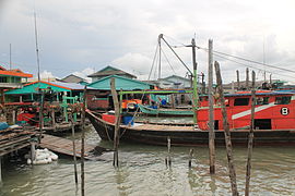
38 Pulau Ketam(Crab Island, Crab Island) - The island is located directly off the coast of Port Klang and can be reached via a one-hour boat trip through the mangroves (see also the tour shown in the dynamic city map). The island was a Chinese fortress, it was settled by Chinese fishermen at the beginning of the 20th century. It had its largest population in the 1980s with around 20,000 inhabitants in the two villages Kampung Sungai Lima and Kampung Pulau Ketam, most of them Chinese (Hokkien). Today the picturesque island is popular with tourists, as there are pretty clapboard-roofed houses, good fish restaurants and no cars. A walk on the paths and footbridges is quite inviting and interesting. Bicycles can also be rented (RM 5.00 / day), although you can walk all the ways. At the end of the shopping street, Jl. Merdeka is the one Hock Leng Keng Temple. The boats to the island leave every half an hour at the port of Port Klang (220 meters south of the Komuter station - you walk straight to it when you leave the train station). The ferries run from 7:00 a.m. to 8:00 p.m. Start is in Port Klang as well as on Pulau Ketam at xx: 45 a.m. (journey time: 35 minutes; price: RM 7.00).

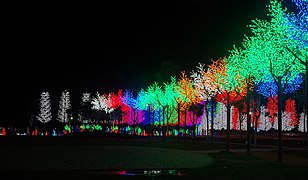
On the way back to Kuala Lumpur, during twilight, it is best to climb up at the Komuter station Padang Jaya out and takes a taxi 39 i-City. The urban area is an urban project that aims to create a fully integrated and intelligent city. A special highlight is the City Park, a small amusement park and a complete landscape that consists only of LEDs - a world that appears colorful and surreal, especially in the dark. In the park area there are restaurants and small rides as well as that Snowalk - an artificial indoor snow experience.


Blue Mosque, Shah ALam

Sultan's Palace, sound
Pulau Ketam
i-City, Shah Alam


Petaling Jaya and Subang Jaya
Petaling Jaya(Petaling Jaya) - briefly from the locals PJ called connects directly to the west of Kuala Lumpur and is easy to reach with the LRT. An interesting tour starts at the LRT station Taman Jaya and first leads to the famous temple 40 Wat Chetawan. The building is officially called Thai Buddhist Chetawan Temple (วัด พุทธ ไทย เช ต วัน). Phra Kru Palat Vieng, a member of the community of Thai monks who lived in Kuala Lumpur for a long time, had the idea of building a temple near the city in 1956, so a piece of land was acquired in the state of Selangor. Even the Thai King Bhumibol Adulyadej and Malaysia's Prime Minister Tunku Abdul Rahman supported this project at the time. The prayer hall and shrines in their current form were built in the 1960s. The interesting architecture now attracts many visitors. Especially at the Thai festivals such as Songkran, Loy Krathong, and Wesak, many followers of this belief come together. Continue north to the university campus. They are worth seeing 41 Muzium Seni Asia (Museum of Asian Arts). The exhibition features 6,000 Malaysian and Asian works of art, mostly ceramics from a period of 4,000 years. The KendiCollection (water container with a spout but no handles) is the largest of its kind in the world. A little further is the office building 42 Dewan Tunku Canselor. The university's chancellor mat is influenced by the style of 1950s architect Le Corbusier, when Malaysia's administrative buildings placed functionality over local, traditional architecture. Two kilometers further you can take a tour of the botanical gardens of the 43 Rimba Ilmu. The Botanical Garden is one of the most important greenhouses in the country, with an exhibition on the environment and the rainforests, a 45-minute walk through The Garden with 5 subject areas: medicinal plants, palms, citrus, ferns and bamboo. A guided tour offers that Conservatory of Rare Plants and Orchids with 1,700 rare plants. The tour should be booked a week in advance. If you still have time and interest, you can spend the rest of the afternoon and early evening in Subang Jaya spend.

- 4 Sunway Lagoon. Amusement park in the northeast of the city and certainly the largest and most famous family attraction. The park is divided into different themed areas. Those who want to enjoy it to the full can also spend a whole day in the city and the Sunway Lagoon. If the entire tour is on the day's program, you should start early.Open: daily 10:00 a.m. to 6:00 p.m.