| Eastern Cordillera (Colombia) | |
 | |
Location  | |
| State | Colombia |
|---|---|
| Region | Andean region of Colombia |
| Surface | 144,252 km² |
Eastern Cordillera (Cordillera Oriental) is one of the three main branches into which the Andes mountain range in Colombia.
To know
The Eastern Cordillera is an economically dynamic and highly populated region thanks to its fertile soils and the abundance of water made up of natural and artificial lakes and a myriad of rivers mostly tributary of the Magdalena river that flows to the west and the Orinoco, part of the Amazon River basin.
Important cities such as, Bogotá, Bucaramanga, Cúcuta, are located on the Eastern Cordillera
Geographical notes
The Eastern Cordillera extends along a southwest-northeast axis, from the node of Almaguer or (Colombian massif), in the department of Cauca on the border withEcuador up to the Perijá mountain range, in the La Guajira peninsula which juts out into the Caribbean Sea.
Its western slope descends into the Magdalena river basin which separates it from the central mountain range, while the eastern buttresses affect the Orinoco region, consisting of the catchment areas of the Amazon, Orinoco and Catatumbo.
At its far north, at the Caribbean region, the Eastern Cordillera is divided into 2 branches that surround the Maracaibo Lagoon: the Sierra de Perijá and the Cordillera de Mérida, which extends to the coasts Venezuelan, well beyond the capital Caracas.
The major orographic features of the Eastern Cordillera are listed below:
- Ritacuba Blanco - (5410 m a.s.l.) It is the highest elevation of the Sierra Nevada del Cocuy, whose peaks are perpetually covered with snow.
- 1 Páramo de Sumapaz (4306 m a.s.l.) -
- Cerro San Luis (4100 m a.s.l.) - In the Parque Nacional Natural Chingaza
- Páramo de Pisba (3906 above sea level) -
- Páramo de Choachí (3870 a.s.l.) -
- Páramo de Cruz Verde (3500 a.s.l.) -
- Macizo Colombiano 3250 above sea level -
- Altiplano Cundiboyacense —
- Sabana de Bogotá —
- Serranía del Perijá —
Territories and tourist destinations
The eastern mountain range crosses the following departments and is their predominant feature:
- Cundinamarca (15%)
- Boyacá (16%)
- Santander (21%)
- Norte de Santander (15%)
The eastern and south-eastern foothills fall into the following departments:
- Huila (7%)
- Tolima (3%)
- Cesar (4%)
- La Guajira
The eastern buttresses extend into the four departments of the Orinoco region:
Urban centers
- 1 Barichara
- 2 Bogotá - Capital of the country.
- 3 Bucaramanga
- 4 Cúcuta - City on the border with Venezuela.
- 5 Guaduas
- 6 Guatavita
- 7 Honda
- 8 The Playa de Belén
- 9 Monguí
- 10 Ráquira
- 11 San Juan de Girón
- 12 Socorro
- 13 Tunja - Capital of the department of Boyacá
- 14 Villa de Leyva
Other destinations
- 1 Los Estoraques (Área natural única Los Estoraques)
- 2 Chicamocha National Park (Parque nacional del Chicamocha) - Famous for the beauty and variety of landscapes, the park was inaugurated in 2006 and is very popular, having its entrance along the road Bucaramanga-Bogotá. Its main attraction is the 167 km long canyon carved by the Chicamocha River. The cable car that takes you to the top of the Los Santos plateau (Mesa de los Santos) passing over the gorges.
- 3 Chingaza National Natural Park (Parque nacional natural Chingaza) - Inside is the large Chuza reservoir built with the damming of the Guatiquía river, a tributary of the Orinoco. The Chuza basin is the main source of water supply in the metropolitan area of Bogotá(about twelve million people). The water is sent through a complex engineering project that includes huge tunnels and intermediate basins such as the San Rafael tunnel in the neighboring municipality of La Calera. In this way it was possible to bypass the barrier of the Andes, guaranteeing the purity of drinking water.
- 4 Cordillera de los Picachos National Natural Park (Parque nacional natural Cordillera de los Picachos)
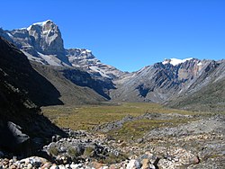
- 5 El Cocuy National Natural Park (Parque nacional natural El Cocuy)
- 6 Cave of Los Guácharos National Natural Park (Parque nacional natural Cueva de los Guácharos)
- 7 Serranía de los Yariguíes National Natural Park (Parque nacional natural Serranía de los Yariguíes)
- 8 Sumapaz National Natural Park (Parque nacional natural Sumapaz)
- 9 Tamá National Natural Park (Parque nacional natural Tamá)
- 10 Sanctuary of flora and fauna of Iguaque (Sanctuary of fauna and flora Iguaque)
How to get
How to get around
What see
What to do
At the table
Safety
Other projects
 Wikipedia contains an entry concerning Eastern Cordillera (Colombia)
 Commons contains images or other files on Eastern Cordillera (Colombia)