| Gadara | |
 | |
Location  | |
| State | Jordan |
|---|---|
| Region | Northern Jordan |
Gadara is an archaeological site as well as the ancient city of Umm Qais in Northern Jordan.
To know
According to tradition, this city would be the biblical land of the Gadarenes (Matthew 8,28-34) where the miracle of the pigs occurred whereby Jesus cast out the demon Legion by a man considered insane. The demon was cast into a group of pigs which threw themselves on the lake of Tiberias (the Sea of Galilee).
Gadara can be seen on a day trip together with Jerash or Ajlun, but all three can be difficult, making it advisable to stay overnight somewhere in the north.
Geographical notes
The site is located in northern Jordan, above the Jarmuk River, which separates Jordan from Israel and forms the border between Jordan and the Syria a little further east.
Background
Gadara (Γάδαρα in Greek) was one of the new Greek foundations in the context of the campaign of Alexander the Great and developed in the following years as a center of Hellenistic culture in the Levant. In 218 BC it was taken by the Seleucid king Antiochus III who by conquering Syria also took Pella. The city received the name Antioch Semiramis.
Later, the Ptolemies tried to conquer the Seleucid region, under the Jew Hasmonäerkönig Alexander Jannaeus, the city was finally taken. When the Romans subjugated Hasmonäerreich, Gadara also fell under Pompey's troops. After the reconstruction, the city occupied a significant place in the union of the Decapolis. A Roman aqueduct was built with a 94 km long tunnel with spring water.
In the Byzantine era, the city became a large episcopal see. With the spread of Islam and the advance of Muslim troops among the caliphs of Rashidum, the nearby area of Jarmuktal became the ground of the decisive battle between the Byzantines and the Muslim troops. After the end of the Byzantine rule in the Levant, the city passed under Muslim rule. Severely hit by an earthquake in 749 AD. the city was abandoned and only in the nineteenth century was it recognized as the ancient city.
How to get
By plane
The reference airport is that of Amman.
By car

At the entrance to the site there is a large 1 free parking.
By bus
The site is about 25 km from Irbid and 110 km from Amman. Minibuses depart from Irbid but it is much easier to reach by car.
Permits / Rates
- 2 Entrance to the site, ☎ 962796716796.
 3 JD (guides are available at 10 JD and some basic brochures are available).
  08:00-19:00. Site of the famous miracle of the pigs, Gadara was renowned in its time as a cultural center. The ruins include a theater, a colonnaded street, Roman shops, temples and houses, and a large Ottoman village that includes a museum.
How to get around
Walking is the only means of transport possible within the site.
What see
- 1 Umm Qais Archaeological Museum (Beit Rousan). At the residence of the Ottoman governor. A small museum with several statues from the site.
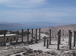
- Decumanus Maximus. The main street of the Roman cities. Includes tombs and black basalt pillars

- 2 East Theater. Made of black basalt, it could hold up to 3000 spectators, it is interesting the presence of some of the seats with intact backs.
- 3 north theater (Near the museum entrance). Little remains of the theater, except the form.

- 4 Byzantine church. Remains of a 6th century Byzantine church with an octagonal chapel on which stand the basalt columns. The church was destroyed by an 8th century earthquake.
- Ruins of the city. A street with old shops above the basilica.
- Colonnaded street. It leads to the remains of an old door.
- Bathrooms. Along the decumanus maximum there are the baths of the fourth century with the presence of the nearby nymphaeum.
- Roman mausoleum.
- 5 Gadara aqueduct. The long aqueduct that passed through Syria supplied the city.


North Theater
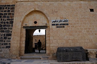
The Archaeological Museum


What to do

- 1 Panoramic point. From this point you can see a wide panorama in a northerly direction beyond the Jordanian border, towards the Sea of Galilee which is precisely to the north-west and part in the region of Sea of Galilee.
- Also visible is the Yarmuk River to the north, behind the Golan Heights.
- The Mount Tabor visible to the west with the imposing and beautiful Church of the Transfiguration.
Shopping
The flowers are sold in the spring when everything is in bloom by some of the local people. Buy some and support the local community.
At the Rest house there is a small shop with various items or at the parking lot there are several street vendors.
Where to eat
- 1 Umm Qais Rest House, Hizam Ring Rd (Inside the site), ☎ 962 02750055. 5-20 JD.. 12:00-01:00. The building is built in an Ottoman school on the site. The food is not cheap but it is very good and the terrace has great views over the valleys (including the Golan Heights and the site itself).
Where stay
- 1 Umm Qais Hotel, ☎ 962 2 750 0080.
Safety
During the visit it may happen to hear gunshots, do not worry nearby there is a Jordanian military range where the soldiers are practicing shooting.
How to keep in touch
Around
- Al-Himma 10 km to the north, a spa town already known in Roman times. There are two factories: privately and publicly run. Note, there are separate hours for men and women.
- Irbid - The main industrial and administrative center in the north of the kingdom.
- Pella - Ancient ruins.