 | ||
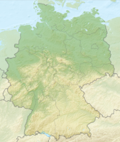
| Great Rachel | ||
| Administrative district | Lower Bavaria | |
|---|---|---|
| height | 1,453 m | |
| no tourist info on Wikidata: | ||
| location | ||
| ||
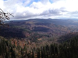
The Great Rachel is the second largest mountain in the Bavarian forest after the one only three meters higher Big Arber and the highest elevation in Bavarian Forest National Park. Characteristic of the area around the Great Rachel is the great destruction of the forest by the bark beetle since 1995. Since the mountain is in the national park and this is under the motto "let nature be nature", no action was taken against the bark beetle, although it did there were major complaints among the population. In the meantime, a new mixed forest is growing back instead of the old monotonous spruce stand.
When the visibility is good, the view from Großer Rachel extends from the Osser and Arber in the northwest by Three armchairs in the south East; in the case of the influence of the foehn or inversion weather conditions, the Alpine chain from the Dead Mountains to the Zugspitze to see. The view is increasingly obstructed by growing trees. Since a free cut is not planned, the prospects will continue to deteriorate in the near future. Even today, a 360 ° panoramic view is no longer possible. [1]
getting there


By car
The closest parking lots are at Big Rachel 1 Parking lot / stop Gäll and 2 Parking lot / bus stop at Racheldiensthütte. In the summer months (please inquire about the exact days at the National Park) these can only be reached with your own car before 8 a.m. and after 6 p.m. "Rachel-Bus" (line 7595) from Spiegelau or hike to Rachel from outside the car-free zone.
With public transport
Spiegelau itself has a rail connection with the forest railway. From 3 Spiegelau station, or the near one 4 Park and ride parking lot Spiegelau perverts the Line 7595 "Rachel-Bus" to the two starting points for hikes on the Rachel "Gälle" and "Racheldiensthütte". The travel time from the Park & Ride car park Spiegelau to the parking lot "Gfall" is 10 minutes, stops on the way are Aufichtenwald-Steg and Seelensteig. The travel time to the Racheldiensthütte from the Park & Ride parking lot Spiegelau out is 30 minutes and leads via Riedlhütte. At the stops 5 Gray saw, or. 6 Diensthüttenstrasse there is also a connection to the Line 7594 "Lusen-Bus" direction Neuschönau (National park center, treetop path). For more information, see the timetable.
By bike / on foot
Even by bike you can get to the two parking lots "Gfall" and "Racheldiensthütte". Here you have to lock your bike and continue to conquer the mountain on foot.
Many hiking trails run over the Great Rachel. Long-distance hiking trails are the European long-distance footpath E6 and the Goldsteig, as a local circular hiking trail, the Auerhahn circular trail, starting from the parking lot and the "Gfung" stop.
Tourist Attractions

.JPG/250px-Waldschmidthaus_(1).JPG)


- 1 Big Rachel (1453 m): The rocky peak can only be reached on foot via hiking trails. From the summit plateau with a wooden cross you no longer have a 360 ° view, as these obstruct the regrowing trees that must not be cut back. Nonetheless, if the visibility is good, you can still go from the Osser and Arber in the northwest by Three armchairs look to the southeast; in the case of the influence of the foehn or inversion weather conditions, the Alpine chain from the Dead Mountains to the Zugspitze to see. The Mountain rescue hut, also made of wood, does not offer any protection during thunderstorms or storms.
- 2 Rachel Chapel (1212 m): The Rachel Chapel above the Rachelsee from 2000 is accessible from the main hiking trail via a short detour, the Kapellensteig reachable. It goes back to an original building in 1885, but this burned down after the Second World War. In 1951 the chapel was rebuilt from wood, but burned down on March 19, 1972 and was rebuilt. At the end of the 1990s, a new building was finally necessary, as the chapel was badly damaged by the effects of the weather and signs of aging. The fourth Rachel Chapel was inaugurated on June 24, 2000, and the legend about the chapel can be read inside.
- 3 Rachelsee (1071 m): The 5.7 hectare, 350 m long and 205 m wide Rachelsee is one of three cirque lakes in the Bavarian forest and is located about 800 meters as the crow flies southeast of the Great Rachel. It is 13.2 m deep at its deepest point, but on average only 3.2 m and has a catchment area of 58 hectares. Due to the acidic water and the associated low ph value of only 5ph, no fish and amphibians live in the lake, only microorganisms. Incidentally, there is one south of the lake Info refuge about the jungle and the ice age as a topic. There are also several legends about the Rachelsee as about the Rachel Chapel.
- 4 Waldschmidthaus (1360 m): The Waldschmidthaus, officially Rachelschutzhaus, is the highest mountain hut in the Bavarian Forest and was taken from the section Spiegelau of the Bavarian Forest Association opened on September 1, 1912. It was named after Maximilian Schmidt, called Waldschmidt, and is open in the summer months from April / May to October / November. Overnight stays have not been possible since 2011 because the mountain hut no longer meets the new guidelines of the Fire Protection Act. A few meters east of the hut is the Lake view above the Rachelsee. (www.waldschmidthaus.eu)
- 5 Little Rachel (1399 m): Little Rachel is about 900 m northwest of Big Rachel and can be reached on foot, among other things, via the Waldschmidthaus and the Rachelwiese to reach. From the summit cross with the summit book a little away from the highest point you can see the Zwiesler Winkel, the Großer Arber, the Falkenstein and the Frauenau drinking water reservoir. Little Rachel can only be reached on an unmarked path, which does not fall under the mandatory routes in the core area. Even from Little Rachel you no longer have a 360 ° panoramic view, just like from Big Rachel, since coniferous trees that are growing here are also not allowed to be cut back.
- 6 Felsenkanzel (1146 m): The Felsenkanzel is a rock that can be climbed with the help of a wire rope on the circular path between Specht Rachelsee and Revenge Service Hut. From the rock plateau you can currently look to the southeast, but this vantage point will soon be overgrown by the growing trees. To the north of the rock pulpit in the small clearing there is a shelter open to the side, which can offer protection in the event of storms. If you already know the Felsenkanzel and don't want to climb it, you can bypass it south on a more direct, easily accessible path. This path does not fall under the mandatory paths in the core zone of the Bavarian Forest National Park.
- 7 Seelensteig: The Seelensteig is a 1.3 km long circular route on the Schwarzachstrasse (Spiegelau-Gfall; closed to cars in summer, see directions). In 1995 he set up a typical mixed spruce, fir and beech forest, in which no wood has been used for around 50 years. The Seelensteig runs gently on a wooden walkway with stairs over obstacles. The stop of the same name is located directly at the start of the Seelensteig, served by the "Rachel-Bus" (line 7595). You can get the leaflet for the hiking trail here download.
- 8 Aufichtenwaldsteg: The Aufichtenwaldsteg is also on the Schwarzachstrasse between Spiegelau and Gfall, which is partially closed to cars in summer (see directions). As a 400 m long wooden plank path, it runs through a type of vegetation typical of this altitude Bavarian Forest. Along the hiking trail, informative wooden boards explain the individual tree and plant species. Just like the Seelensteig, the Aufichtenwaldsteg also has its own stop of the same name, served by the "Rachel-Bus" (line 7595). You can also get there on foot, as the Aufichtenwaldsteg north of Spiegelau lies.
activities
.JPG/250px-Rundweg_Auerhahn_(1).JPG)
.JPG/250px-Rundweg_Auerhahn_(2).JPG)
.JPG/250px-Rundweg_Auerhahn_(3).JPG)
.JPG/250px-Rundweg_Auerhahn_(4).JPG)
.JPG/250px-Rundweg_Auerhahn_(5).JPG)
.JPG/250px-Rundweg_Specht_(1).JPG)


Tour suggestion: "Route hike Rachelübergang"


From the stop "If necessary"with parking lot (950 m) follow this Capercaillie circular route through the still intact forest, partly steeply uphill over the access road to the Waldschmidthaus. Soon you will come to "Lieslbrunn"(1200 m), which lies directly on the hiking trail. Shortly afterwards, the vegetation changes, the deciduous trees have to give way to the dead conifers. The hiking trail becomes flatter again here, the Klingenbrunner Rachelsteig comes up the mountain from the south and you finally reach it 1 Waldschmidthaus (1360 m). From this a short branch path leads to "Lake view", from which you can see the Rachelsee and up to the Lusen. Back at the Waldschmidthaus you now hike on unpaved, very stony paths up to the 9 Rachel Summit (1453 m). From the mountain guard hut below the summit you finally have to climb the rock on which the summit cross stands. At the moment there is still a beautiful panoramic view from the summit cross, but this will be overgrown in the future by regrowing trees. We continue on the north side of the Great Rachel. Here you can see the destruction of the forest by the bark beetle, the view extends from the hiking trail into the Czech Sumava National Park. Later you can take a short detour via the Kapellensteig to 10 Rachel Chapel (1212 m) make, one of the most photographed subjects in Germany. Behind this, the vegetation changes back to the deciduous trees. You reach a fork in the road on a beautiful, but also stony, path. Who goes west, reaches the 11 Rachelsee (1071 m) and can walk back to the Gfung stop, but we are going east, now on the Woodpecker trail about 50 meters uphill again to the 12 Rock pulpit (1146 m) with a refuge. From this vantage point, too, which can be reached via a secured point, the view can now only be enjoyed in parts; growing trees obstruct the view considerably. From now on it only goes downhill on the Specht circular path, soon again on a paved gravel path to the 2 Revenge Service Hut (865 m). From the Racheldiensthütte it's only a few hundred meters downhill across a clearing to the Parking lot / bus stop at Racheldiensthütte.
Tour data: Route length around 10 to 11 km with around 600 m ascent. The use of sturdy footwear (ideally ankle-high hiking boots) is highly recommended, as natural, sometimes stony mountain paths are used over large stretches. If there is a risk of thunderstorms, do not tackle the hike, as long open stretches through dead forest have to be covered in the Rachel's summit area. Even in a storm you should refrain from hiking, as there is then an increased risk of breakage due to dead wood. The pure walking time is around four hours.
kitchen
- 3 Waldschmidthaus. Tel.: 49 172 7850362. The Waldschmidthaus is located south of the Großer Rachel and is open in the summer months from April / May to October / November. Unfortunately, overnight stays are no longer possible since 2011.Open: 9 a.m. - 6 p.m.
- 4 Revenge Service Hut, Racheldiensthüttenstrasse. Tel.: 49 8553 6033. The Racheldiensthütte is located southeast of the Großer Rachel and is managed in the summer months from April / May to October / November.
security
Big Rachel should be avoided during thunderstorms. Since most of the trees around have died, there is no shelter on the entire mountain!
The Bavarian Forest National Park also offers a large-scale rescue plan in which helicopter landing pads, shelters and all passable roads are marked.
Practical advice
In the summer months, the national park rangers are at your side every day on the summit of the Great Rachel. You should also note the proximity to the Czech border. Cell phones may already be able to switch to the Czech cellular network, data roaming should definitely be switched off!
Web links
- Rachel hiking area on the pages of Bavarian Forest National Park.
- Leaflet "Off to Rachel"; published by Bavarian Forest National Park.
Individual evidence
- ↑Rachel all around: limited view - 360 ° panorama from the Rachel summit