| Jebel Shams جبل شمس, mountain of the Sun | |
.jpg/250px-Jebel_Shams_(2).jpg) | |
| State | Oman |
|---|---|
| Region | Northern Oman |
| Territory | Al-Batina region |
| Mountain range | Ḥajar Mountains |
| Height | 3,075 m a.s.l. |
Jebal Shams or Jabal Shams is located in theNorthern Oman.
To know
Geographical notes
This is Oman's highest peak, with several excellent hiking trails offering spectacular views over Wadi an Nakhur and 1 Wadi Ghul. The summit looks like a plateau overlooking the surrounding wadis.
Flora and fauna
.jpg/220px-Oman_Day1-011_(8480782710).jpg)
The mountain is almost barren with sparse bushes. On the summit grow olive trees that resist those conditions. The little fauna is represented by the rather sociable goats and some birds of prey.
Territories and tourist destinations
Urban centers
Other destinations
- 1 Ghul - This village with its charming old town is located along the W6A hiking trail.
How to get
By car

It is possible to visit it as a day trip from Nizwa, but as with Jebel Akhdar it is best to take a couple of days for this excursion.
From Nizwa, head west off Highway 21 and turn north on 2 street indicated for Al Hamra. Proceed north for 12km and to the 3 roundabout Turn left. Continue until 4 end of the paved road. The road approaching Jebel Shams is unpaved in the last 13km but is regularly graded and well maintained. Occasionally, however, it gets washed after heavy rain, after which it becomes impractical without a 4WD. Depending on the weather and current road conditions, it may be possible to drive to the end with a 2WD, but those with a rental car should note that driving off the asphalt will void car insurance.
How to get around
Most of the paths are unpaved so the use of a 4x4 is necessary. There are also several hiking trails.
What see

Viewpoint 1
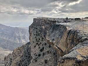
View at viewpoint 1
View at the viewpoint 3

Viewpoint 3


- 1 Viewpoint 1. This point at the top of the mountain offers the first beautiful views of Wadi an Nakhur located further down. A newly built parapet makes the view safe as the drop below is impressive. There are junk sellers nearby.
- 2 Jabal Shams Observatory, ☎ 968 9808 0775.
- 3 Viewpoint 3. This point offers a different panoramic perspective but there are no parapets, so you need to be more careful.
- 4 Al Khitaym (After the viewpoint, continue along the dirt path). Where villagers sell woven goatskin rugs and bags. This dirt path is particularly bumpy, so the use of an off-road vehicle is recommended.
- 5 As Sat (Sap Bani Kamis) (From Al Khitaym there is the path for the trekking route W6 (Abandoned Village) An easy one hour trek along an ancient donkey trail). An abandoned village, built directly on the side of the cliff. Notable features of this unlikely location include mill ruins, cave dwellings, terraces, and during the rainy season, a waterfall.

Al Khitaym
.jpg/338px-Sap_Bani_Khamis_2019_(01).jpg)
As Sat
.jpg/300px-Wadi_an_Nakhur_(36313125243).jpg)
Wadi an Nakhur
.jpg/338px-Oman_2014_(16035650458).jpg)
Old Ghul

.jpg/338px-Sap_Bani_Khamis_2019_(01).jpg)
.jpg/300px-Wadi_an_Nakhur_(36313125243).jpg)
.jpg/338px-Oman_2014_(16035650458).jpg)
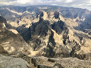
- 6 Wadi an Nakhur (Wadi Ghul) (The canyon is accessed from the road that climbs Jebel Shams and turns right near the village of modern Ghul.). Wadi an Nakhur is the deepest canyon in the Middle East and according to some it is the second deepest canyon in the world after the Grand Canyon in Arizona. It is also sometimes called Wadi Ghul, although technically Wadi Ghul marks the mouth of the canyon, and Wadi an Nakhur is the proper name for the canyon at its widest point.
- 7 old Ghul. Ruined village next to the modern settlement. Visible from the road that goes up to Jebel Shams, with a space to stop along the curve.
What to do
- 1 W4 (Start of the path W4). This trail takes you to the top of the mountain on a challenging 11-14 hour hike.
- 2 W6a (Start of trail W6a). The trail begins at the old Ghul. The road then passes through the village of Al Hajir, after which the uneven road ends. Here it degrades quickly to a bumpy road that requires 4-wheel drive, but persistence is rewarded with spectacular views of the 1000m-high rock faces. After 7 km the road ends in the village of An Nakhur.
Shopping
When you reach the top you will see shacks where locals sell souvenirs and handicrafts. On the street you can meet children who try to sell some souvenirs.
Where to eat
Apart from the resorts there are no dining options.
Where stay
- 1 [link not working]Sunrise Resort, ☎ 968 9266 3837.
- 2 Sama Heights Resort (Jabal Shams Height Resort or Jabal Shams Base Camp), ☎ 968 927 219 99.
- 3 [link previously not working]Jebel Shams Resort, ☎ 968 9938 2639. It is a comfortable place to spend the night. Shortly after the resort the paved road ends again; good camping spots and some other observation points are just a little further on.
Safety
The unpaved road sections up to the summit are barrier-free. Avoid driving the latter at night as visibility is very poor.
Maximum attention must be given when looking out to see the view, in several points the cliff is really dangerous and the risk of tripping or slipping is high.
How to keep in touch
Around

- 5 Al Hoota cave (كَهْف ٱلْهُوْتَه, Kahf Al-Hūtah, Al Hutah, Al Hotta, Al Fallah, Al Falahi), Al Hoota Cave Rd (exit from highway 21 towards Al Hamra), ☎ 968 24 498258 (reservation required), @[email protected].
 RO 7 / 3.5 (tourists / children 6-12), RO 3.5 / 1 (Omani adults / children 6-12), free (children under 6) (Nov 2019).
  Sat-Thu 09: 00-13: 00, 14: 00-18: 00; Fri 09: 00-12: 00, 14: 00-18: 00. A 2.7km long cave network with a large chamber of stalactites and stalagmites, as well as an 800m long lake, which is home to a species of blind fish. There's also an on-site geological museum, as well as a café and gift shop.
- Bahla
Other projects
 Wikipedia contains an entry concerning Jebel Shams
 Commons contains images or other files on Jebel Shams