| Ḥajar Mountains جِبَال ٱلْحَجَر, Jibāl al-Ḥajar | |
.jpg/250px-Oman_(10).jpg) | |
| State | Oman |
|---|---|
| Region | Northern Oman |
| Height | 3,009 m a.s.l. |
Ḥajar Mountains are located in theNorthern Oman.
To know
This spectacular mountain range offers numerous attractions for adventurous travelers, including hiking, rock climbing, canyoning, and 4WD exploration. In addition to outdoor activities, there are numerous attractions of historical, cultural and geological interest.
Geographical notes
The Hajar Mountains stretch along the northern coast of Oman, from the southwest of Muscat ai United Arab Emirates.
When to go
Temperatures at higher altitudes tend to be on average 10-15 ° C colder than in Muscat and snow, although very rare, is not unknown. In the summer the mountains offer a refuge for those looking to escape the heat while the rest of Oman is there Arabian peninsula cooks.
Territories and tourist destinations
Urban centers
- Al Hamra - Located right at the base of the mountains, this city is famous for a number of Yemeni-style mud brick buildings, some of which are among the oldest houses in Oman. They are located in an older part of the city and overlook the newer city; in recent years many of the older houses have been abandoned as the inhabitants have chosen to move to more modern buildings.
- Nakhal - Picturesque village dominated by a fort.
- Nizwa - with the most famous fortresses of Oman
- Rustaq
Other destinations
- 1 Jabal Akhḍar - Mountain of about 3,000 m also called "green mountain".
- 2 Jebel Shams - The highest mountain in Oman with its fantastic landscapes and a record-breaking canyon
How to get
By car
From Muscat, highways 15 and 21 skirt the southern stretches of the mountains and highways 13 and 11 provide access from the north. UAE travelers will arrive via Highway 21.
How to get around
It is possible to glimpse some of the spectacular mountain scenery with just a 2WD, but to really explore a 4WD is essential, as many highlights would otherwise be simply inaccessible.
What see
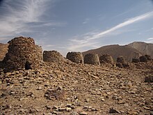
In this area, the prehistoric sites of Bat, Al-Khutm and Al-Ayn dating back to the 3rd millennium BC, were jointly inscribed on the UNESCO World Heritage List.

 1 Bat (from Highway 21, turn north at the petrol station between Nizwa and Ibri, following signs for Amla, Al Ayn, Damm / Dham and Sint).
  Free. This 3rd millennium BC site it was excavated in 1976 and includes common graves, ruins of forts with towers and beehive tombs. It consists of over 100 tombs and circular buildings with a diameter of 20 meters, the use of which is unknown. Since the buildings have no openings to the outside, the hypothesis has been advanced that they were cisterns or silos, but these are only conjectures.

- 2 Al-Khutm (2 km west of Bat). Free. This 3rd millennium BC site it contains the ruins of a stone tower of 20 m in diameter.

- 3 Al Ayn. Free. These unexcavated beehive tombs are in much better condition than Bat's, with the spectacular backdrop of Jebel Misht and its 1000 meter high cliffs. To access it, take the road to the left (just beyond the intersection), turn right and walk 100m along the Wadi. From here a path leads to the tombs.

- 4 Wadi Tanuf (Wadi Tanoof) (access from highway 21). At the mouth of the wadi are the photogenic ruins of ancient Tanuf, which was heavily bombed by the British Royal Air Force during the 1954-1955 Jebel Rebellion. A 4WD track proceeds along the wadi past a charging dam to trails for W19 and W19a (unmarked), two excellent hikes through and over nearby Wadi Qashah.
.JPG/220px-Misfah_(14).JPG)
- 5 Al Hoota cave (كَهْف ٱلْهُوْتَه, Kahf Al-Hūtah, Al Hutah, Al Hotta, Al Fallah, Al Falahi), Al Hoota Cave Rd (exit from highway 21 towards Al Hamra), ☎ 968 24 498258 (reservation required), @[email protected]. RO 7 / 3.5 (tourists / children 6-12), RO 3.5 / 1 (Omani adults / children 6-12), free (children under 6) (Nov 2019).
 Sat-Thu 09: 00-13: 00, 14: 00-18: 00; Fri 09: 00-12: 00, 14: 00-18: 00. A 2.7km long cave network with a large chamber of stalactites and stalagmites, as well as an 800m long lake, which is home to a species of blind fish. There's also an on-site geological museum, as well as a café and gift shop.

- 6 Misfat al Abriyyin (Misfah) (5 km north of Al Hamra). One of the few mountain villages accessible by 2WD on an asphalted road. The ancient village is set in a beautiful setting, with terraced gardens and a falaj irrigation system. The ruined fort of Al Rogan it overlooks the village, which is the starting point for the demanding hiking trail 'W9' , which connects with the trails W8 is W10h . Donkeys and guides are available for hire here as well.
.jpg/220px-Nakhal_Fort_(2).jpg)
- 7 Fort Rustaq (قلعة الرستاق). Sat-Thu 09: 00-16: 00; Fri 08: 00-11: 00, 14: 00-16: 00. This restored fortress at the foot of the mountains to the north has four watchtowers and dates back to the 13th century. The complex includes a mosque, a former prison and a falaj system. It was nominated to be classified as a UNESCO World Heritage Site.
- 8 Fort Nakhal (قَلْعَة نَخَل, Qalʿat Nakhal), ☎ 968 26 781384. 500 Bz (adults). Sat-Thu 09: 00-16: 00; Fri 08: 00-11: 00. A restored fortress with a history dating back to the pre-Islamic era, set in a scenic location on a rocky outcrop at the base of the northern Hajar Mountains. The fort houses a museum of historical guns.
- 9 Little Snake Canyon.
- 10 Snake Canyon (Snake Gorge).
- 11 Balad Sayt (Bilad Sayt). Small mountain village
- 12 Jaylah Tombs (to reach the site you can follow this itinerary). On this site there are about 90 tower tombs of the Umm an Nar civilization, i.e. between 2700 and 2000 BC. erect with overlapping stones and circular in shape reminiscent of those of Bat.
Itinerary
What to do
Trekking

There are a number of trekking routes in the Hajar Mountains, ranging from simple 2-hour walks to challenging 10-hour hikes. Numerous routes follow ancient donkey trails and have been in use for centuries. The Oman Ministry of Tourism has begun marking many of these routes, with maps and descriptions available online; an overview map is available for download here and detailed trail maps can be downloaded here is here. Two of the more popular (and simpler) routes include W6 (Abandoned Village Walk) is W18b (Village Walk). In general, the trekking season runs from September to May, with the best months from October to April. Trekking is possible all year round at altitudes above 1900 m.
Oman Trekking is a collection of the trails and maps listed above, printed on Explorer Publishing weather-resistant cardstock and available in English-language bookstores in Oman and the United Arab Emirates. Also Adventure Trekking in Oman by Anne Dale and Jerry Hadwin is a great guide, even if it is out of print and increasingly difficult to find.
Rock climbing
There are some excellent climbing areas. Well known areas are the Wadi Bani Awf (described in the itinerary) and the spectacular 1 Jebel Misht (near the UNESCO site of Bat and Wadi Al Ayn), with many paths still not marked. Climbers should be aware that Oman does not have a mountain rescue service and, in the event of a medical emergency, help could be waited for a long time, especially in more remote areas.
Three paths have been established. Two are currently closed for maintenance, but the 2 VF1 (Grand Canyon) is now open.
The Wall, handled by Muscat Diving & Adventure Center[link not working], is Oman's only rock climbing gym and is a good place to get topographic maps and route information, as well as to find climbing partners.
Shopping
Where to eat
Where stay
.jpg/220px-Camping_site_(5315979822).jpg)
Apart from a handful of accommodations, or in the neighboring one Nizwa, accommodation options are few and expensive, but include full board.
Wild camping is permitted anywhere outside inhabited or cultivated areas; to camp near a village it is always best to ask for permission first. Inexpensive basic camping equipment can be purchased at any of the hypermarkets in Muscat and can also be hired from some tourist facilities.
Beware of camping at or near wadis, especially during the winter months, as flash floods are not uncommon. Nights can be cold even in summer and in winter they often drop below 0 ° C. If you sleep outside, be aware that scorpions and goats can be a nuisance.
- 1 Misfah Old House, ☎ 968 99 338491, @[email protected]. RO 25 / single, RO 50 / double, including half board; Cash only. One of the few accommodation options available in the village, in a traditional Omani house with Omani cuisine prepared by local families. Here you can make arrangements for the guides. Without internet.
- 2 [link previously not working]Shorfet Alalamin (فندق شرفة العلمين), ☎ 968 9944 9071. A few steps from the homonymous viewpoint and next to the path W10h.
Safety
Almost every year there are casualties due to flash floods - wadis can become raging streams in a moment and without warning. If the sky is overcast or cloudy, even if not in the immediate vicinity, it is always best to stay outside. If you camp in a wadi, be prepared to move camp if the sky looks threatening.
For particularly remote destinations, it is always advisable to increase caution.
Dehydration is always a risk. Bring plenty of water - schedule 3 liters per person per day.
How to keep in touch
Telephony
Mobile phone coverage in the mountains is poor or non-existent and there is no mountain rescue service.
Around
Other projects
 Wikipedia contains an entry concerning Ḥajar Mountains
 Commons contains images or other files on Ḥajar Mountains