_La_Palma_&_La_Gomera_Islands,_Canary_Islands_(cropped).jpg/300px-(Isla_de_la_Palma)_La_Palma_&_La_Gomera_Islands,_Canary_Islands_(cropped).jpg) | ||
| La Palma | ||
| region | Canary Islands | |
|---|---|---|
| Residents | 81.350 (2017) | |
| height | 2,426 m | |
| no tourist info on Wikidata: | ||
| location | ||
| ||

The island La Palma, actually San Miguel de la Palma, is the most northwest of the Canary Islandswho are one of the Comunidades Autónomas (Autonomous Communities) Spain form and belongs to the province of Santa Cruz de Tenerife.

The archipelago lies in the Atlantic Ocean between Morocco, Cape Verde and Madeira as well as the Azores. With an area of 708 square kilometers, La Palma is the fifth largest of the Canary Islands. The capital of the island is Santa Cruz de La Palma, on the west side of La Palma is the largest city of the island, Los Llanos de Aridane. The nickname of La Palma is "La Isla Bonita" (the beautiful island).
Regions
The other islands of the Canaries are La Gomera, El Hierro, Tenerife, Gran Canaria, Fuerteventura and Lanzarote.
places
The administration of La Palma is divided into 14 municipal districts: (Population[1])
- Santa Cruz de La Palma, In the island's capital (mostly only Santa Cruz 14,626 inhabitants (2005) live. It is located on the eastern side of the island, the municipality has 17,644 inhabitants (2006) and covers an area of 43.62 km².
- Los Llanos de Aridane, the largest city on the island with 20,173 inhabitants (2006) and an area of 35.79 km². It is located on the western side in the Aridane Valley. Los Llanos is always called that too secret capital designated. It includes the villages of Todoque, La Laguna, and Puerto Naos (largest tourist center on the west side of the island).
- El Paso is geographically the largest municipality (135.92 km²), it is located above Los Llanos under the Cumbre Vieja (range of hills). Villages such as Las Manchas and San Nicolas belong to it.
- Tazacorte, is the youngest (independent since 1925) and in terms of area the smallest municipality on the island of La Palma. It stretches along the western coast of La Palma from the end of the Barranco de Las Angustias gorge to the town of Las Hoyas and is particularly well protected from the trade winds. The fishing and leisure port has been expanded since 2005.
- Fuencaliente de La Palma also called Los Canarios, is the southernmost village on the island. It is located in a modern volcanic landscape in which very good wine thrives, namely the Malvasia, which was mentioned in the works of Shakespeare as early as the 16th century. The two volcanoes are located in the municipality San Antonio (657 m) and Teneguia (439 m, last eruption October 26, 1971, thus the archipelago's last volcanic eruption so far).
- Salt is still extracted today in the Fuencaliente saltworks. It is the last saltworks in the Canarian province of Santa Cruz de Tenerife that is still in operation today.
- Garafía is the northernmost of the 14 municipalities on the Canary Island of La Palma. The main place is called Santo Domingo de Garafía. Garafía as a municipality has 1,886 inhabitants (2006) on an area of 102.99 km² and is still very much rural, individual places on the rugged north coast can only be reached via unpaved slopes to this day.
- Punta Gorda lies between Garafía and Tijarafe (1,962 inhabitants (2006), area: 31.1 km²).
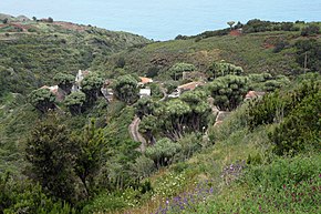
- Barlovento is located in the north-east of the island (2,506 inhabitants (2006), area: 43.55 km²). Under the influence of the humid northeast trade winds, the very mountainous and forested municipality is rich in water reserves. Banana, potato, avocado and citrus plantations form the basis of the local economy. Tourism has so far been a rather minor economic factor.
- Villa de Mazo is located in the south-east of the island (4,889 inhabitants (2006), area: 71.78 km²). The island's airport is on the coast of Vila de Mazo.
- Tijarafe (2,720 inhabitants (2006), area: 53.76 km²) is located on a protected hillside on the west coast and is characterized by particularly diverse vegetation.
- San Andrés y Sauces, the greenest municipality on the island with fertile soils, has 5,020 inhabitants (2006) on an area of 42.75 km². The laurel forest, which has been declared a biosphere reserve by UNESCO, is well known Los Tilos. This remnant from the Tertiary is now one of the largest contiguous laurel forests on earth.
- Puntallana (2,368 inhabitants (2006), area: 35.09 km²) is located between San Andrés y Los Sauces and the island's capital Santa Cruz de La Palma. This community is also rich in springs and fertile soils, so that the cultivation of fruits, vegetables and wine is possible.
- Breña Alta (Full name: Villa de Breña Alta) has 7,185 inhabitants (2006) and an area of 30.82 km². The administrative seat of the municipality is San Pedro de Breña Alta.
- Breña Baja (Full name: La Muy Noble y Honorable Villa de Breña Baja) is a municipality on the east side of the island (4,470 inhabitants (2006), area 14.20 km²), to which a.o. Los Cancajos (also Playa de los Cancajos), the second largest holiday resort on the island with around 2000 beds. Los Cancajos has two small, black-sand bays that gently slope towards the sea with man-made beaches.
Other goals
background
Stone Age and Antiquity

The Canary Islands were established from around 2000 BC. Settled in several batches by the Guanche people, who immigrated from North Africa and were allegedly related to the North African Berbers. This relationship is no longer controversial among scientists today. This is supported by the genetic analyzes of skeletal finds as well as North African language remnants. However, archaeological excavations also indicate a settlement from southwest Europe. The light skinnedness of the old Canarians speaks for such a settlement from Europe. The Guanches lived on a Stone Age cultural level and were organized in different clans that divided the islands among themselves. There is no reliable information about the size of the population. The total number of inhabitants of all islands shortly before the Spanish conquest, at the beginning of the 15th century, is assumed to be around 50,000–70,000.
Your name is derived from the designation Guanchinet (in the language of the Guanches Guan = human and Chinet = Tenerife) and originally probably only referred to the natives of Tenerife. The old Canarian name of La Palma was Benahoare.
The Canary Islands may have been known to Phoenician seafarers since ancient times, records by Pliny the Elder from the 1st century. report on expedition of the Mauritanian King Juba II to the Canaries. They are also mentioned in Ovid's Metamorphoses. On Ptolemy's map of the world from the 2nd century. the prime meridian leads through El Hierro, he chose the western end of the then known world as a reference point, namely the island of Ferro (today's name: El Hierro), and named it Isla del Meridiano. This Ferro meridian was next to the Paris meridian until 1884 (when Greenwich was established as an international reference point) the most widespread prime meridian.
Spanish conquest
In 1312 Lancelotto Malocello, a Genoese merchant and seafarer, reached the Canary Islands (the island of Lanzarote is said to take its name from him). In July 1402, Jean de Béthencourt set sail from Cádiz. Officially it was a crusade, in reality it was about conquering the Canary Islands. This expedition also included two chaplains, they were supposed to proselytize the Guanches and document all so-called heroic deeds, with the chronicle Le canaries originated. In the following four years the islands of Lanzarote, Fuerteventura and El Hierro could be conquered. The attempt to conquer Gran Canaria in October 1405 was unsuccessful. He also failed on La Palma and Gomera.
After the heirless Béthencourt's death around 1425, ownership of all the islands fell apart, and around 1448 the de las Casas - Peraza families from Seville gained all rights over the islands. Then began a period of exploitation and slave hunting on the as yet unconquered islands and nearby Africa. The people of Lanzarote and Fuerteventura fled to Gran Canaria, the islands were repopulated by Berber slaves who hunted the feudal lords on the African coast.
In June 1478, field captain Juan Rejón came to Gran Canaria on behalf of the Catholic kings Ferdinand II of Aragon and Isabella I of Castile, founded Las Palmas and began the conquest of the island, which, however, could only be completed by Pedro de Vera in 1483.
The conquest of La Palma began on September 29, 1492, when Alonso Fernández de Lugo came ashore on the beach of Tazacorte, coming from Gran Canaria. Hardly any resistance was offered to him, the districts Aridane, Tihuya, Tamanca and Ahenguarem submitted. The rulers of Tigalates however, faced enormous resistance. Finally, all the princes of the Benahoaritas, the indigenous people of La Palma, converted to Christianity, except for the district of the Caldera de Taburiente, which was then Aceró ("Strong place") was called. This area was under the control of the famous Tanausú, who resisted and could only be captured by an ambush. Fernández de Lugo, who had already fought on Gran Canaria, finally subjugated La Palma on May 3rd, 1493. On this day, the so-called "Day of the Holy Cross", he founded the city where today Santa Cruz de La Palma is located Villa de Apurón and became governor of the island. He distributed the land and the water resources and set his nephew Juan, who in 1502 also reached the almost inaccessible Caldera de Taburiente, as governor of La Palma.
Fernández de Lugo finally ended the Conquista in 1496 with the third major battle on Tenerife, the Battle of La Victoria de Acentejo. That meant the final submission of Tenerife and thus the last of all the Canary Islands.
Human trafficking, viticulture and American trade
After the Spanish conquest, a large part of the indigenous population was sold as slaves. It is estimated that only around 300 families were spared this fate.
From the beginning of the 16th century. sugar cane plantations were established by de Lugo and his family, which was the most profitable agricultural product at the time. From the middle of the century, however, the cultivation of sugar cane was no longer worthwhile, production in Central and South America was cheaper. Many of the plantations have now been planted with vines. The sweet Palmerian Malvasia was until the 19th century. especially appreciated in England and became the most important export product from La Palma.
In the 16th century, after Antwerp and Seville, La Palma was the third port city to receive the royal privilege to trade with America. Santa Cruz de La Palma quickly developed into one of the most important ports of the Spanish Empire. In the following period there were repeated pirate attacks, so in 1553 the French under François Le Clerc (called "Jambe de Bois") plundered the city and burned it down. The churches, monasteries and houses were rebuilt larger and more splendid, and new defenses were built. In 1585, the attack by the Englishman Sir Francis Drake was successfully repulsed.
In addition to wine, tobacco was now also grown and La Palma was considered a leader in the breeding of silkworms and the processing of silk. The American trade brought prosperity and attracted craftsmen (shipbuilders, cloth and sail makers) as well as merchants from foreign countries. This is how one can still find Flemish family names today.
The decline began as early as the middle of the 17th century. According to a decree from 1657, all ships on their way to America had to be registered in Tenerife and pay their duties there. The trade in the port of Santa Cruz de La Palma almost came to a standstill. At the beginning of the 19th century, due to the changed taste of the customers, the trade in Malvasia wine also collapsed.

Bananas
One way out of the crisis was the large-scale cultivation of bananas from 1878 onwards. Canario Pedro Reid and Briton L. Jones planted the small variety "Eanes Cavendish" from tropical Asia. Several hundred liters of water are required to produce one kilo of bananas, which is why kilometers of irrigation systems with open channels were built, some of which were cut through rocks and pipes laid. They channel rainwater from the mountains down to the plantations. The farmers store their water in huge tanks. The intensive monoculture, which is operated here with the banana cultivation, leads from time to time to bottlenecks in the irrigation even on the green, water-rich island of La Palma. Since the costs for water and wages on La Palma are more expensive than in the Central American growing areas, the Canarian banana production is subsidized with EU funds. The banana is still the most important export item. After trying in recent years to copy the perfect bananas from Central America, today we are thinking again about the advantages of the robust dwarf banana "Eanes Cavendish": Small, but aromatic and sweet.
Modern times
Officially 86,000 people live on the island, in reality it is more like only about 70,000. Ethnically, the population is composed mainly of Hispanics (mixture of Spaniards, Berbers and Portuguese), a part consists of returned emigrants from Central and South America. The proportion of African and Eastern European immigrants is increasing slightly, but without reaching any significant number. Since the 80s of the 20th century, many foreigners, especially from Germany, Switzerland and the Netherlands, have settled permanently on La Palma or set up a second home.
The island mainly exports bananas and tobacco (cigars, so-called. Palm Eros - The production of the cigarette factory in El Paso was relocated to Germany at the end of 2000), and increasingly other fruits, the cultivation of which uses less water, such as avocados. The cultivation of wine was also increased. In addition to the sweet Malvasia, mainly dry red (Listán negro, Negramoll) and white wines (Listán blanco) are produced. On the island of La Palma there is a Denominacion de Origen (DO) of the same name, a Spanish classification for wines with a certain origin. The DO La Palma comprises around 900 hectares of vineyards and is divided into three subzones: Fuencaliente Las Manchas, Hoyo de Mazo and North del Palma.
Recently, the island is increasingly focusing on tourism. With an offer of around 13,000 beds, one cannot yet speak of mass tourism on La Palma, there are only a few larger hotels, mainly holiday apartments are rented in small complexes. Island administrators, mayors and environmental organizations have very different views on how many tourists the island could handle. The numbers once went up to 80,000 guest beds. A maximum bed capacity of 20,000 is now being targeted.
On November 6th, 2002 it was decided to extend the biosphere reserve "Los Tilos" to the entire island area. The name was in "La Palma World Biosphere ReserveThe declaration of the whole island as a world biosphere reserve made it possible to include other ecologically valuable areas, such as the Caldera de Taburiente National Park, but also towns and villages in the reserve. It is precisely these settlement areas that bear the brunt of the sustainable development of the island. They are also the ones that burden the various ecosystems of the island the most.In December 2006, La Palma was dated International Center for Responsible Tourism, which is affiliated with UNESCO and the World Tourism Organization, has been awarded the certificate “First sustainable holiday destination in the world”.[2]
On the Roque de los Muchachos there is an observatory with 15 telescopes since 1985. 19 countries and 60 institutions are involved. In consideration of its sensitive instruments, a Law of Heaven (Ley de Cielo) enact. Protection from „Light pollution“ was expanded several times in the following years, since 2012 the island has been the first in the world UNESCO Starlight Reserve. Guided tours are possible by appointment!
language
Before the Canary Islands were conquered, the language was used by the indigenous people, the "Guanches" Guanche spoken, this original language has died out, but a few words have survived. The official language in the Canary Islands is Spanish, The Canarian dialect is characterized by Latin American influences (the replacement of the 2nd person plural by the 3rd person plural and the almost complete omission of the letter "s" in the pronunciation) or its own word meanings.
getting there
By plane
The island has its own airport (Aeropuerto de la Palma, IATA code SPC) approx. 8 km south of the city center of Santa Cruz de La Palma.
This is served by European charter airlines, mainly from Germany, England, Belgium and the Netherlands, Iberia flies daily to the Spanish capital Madrid. Binter Canarias connects La Palma with Tenerife, Gran Canaria, El Hierro and Lanzarote. The flight time from Germany is approximately 4 ½ to 5 hours.
By boat
La Palma has two ports in Santa Cruz de la Palma and Puerto de Tazacorte (The latter has been expanded extensively in recent years, but is hardly used). From the port of Santa Cruz de La Palma there are ferry connections to the neighboring islands (daily fast ferry of the shipping line Lineas Fred. Olsen on the route Santa Cruz de La Palma - Los Cristianos (South Tenerife), travel time approx. 2 hours) and to the Spanish mainland (between Santa Cruz de La Palma and Cadiz with a stop on Lanzarote, Gran Canaria and Tenerife, once a week). Since June 2005 there has also been a ferry connection from the island's largest fishing port in Puerto de Tazacorte via Santa Cruz de La Palma to the neighboring island of Tenerife.

mobility
The Rent a car is the best way to get to the wild and remote areas of the island. Well-known local landlords are Cicar,La Palma 24, Monta Rent a Car and Cars Taburiente. The fuel is much cheaper than in Germany.
buses are the most widely used method of public transportation. The three most important lines connect the two largest cities of Santa Cruz and Los Llanos via different routes, with frequent connections also to the holiday resorts of Los Cancajos and Puerto Naos. The Timetable is aimed at connecting the localities, tourist interesting destinations such as the Roque de los Muchachos or the Refugio de la Pilar are not approached. An official route plan is not published, an overview can be found e.g. here. By using transferable prepaid cards (Bonobus), a discount of 20% on the fare can be achieved. These cards are available in advance at kiosks near the main stops in Santa Cruz and Los Llanos and can be topped up on the bus if required. You shouldn't expect the driver to speak more than a few words in English or German, but most of the time he tries to help.
Taxis can be expensive (e.g. airport Tazacorte approx. 40 to 45 €). In the cities they are not worth the money, unless you are in a hurry or cannot find your way back to the hotel after a shopping spree. However, it is unlikely that you will be price-cheated.
Tourist Attractions
- The old town of the island's capital Santa Cruz de La Palma has been declared an art historical monument. The main thoroughfare is the Avenida Maritima, the embankment road, which is only built on the land side. Here you can see new representative buildings as well as old houses in the Canarian and colonial style with artistically decorated wooden balconies. Other interesting old palaces can be found on Calle O'Daly, the main shopping street. The old one is at the adjacent Plaza España Town Hall (Casas Consistorales) from the 16th century with its wooden coffered ceiling. Its facade, richly decorated with stone carvings, is considered an outstanding example of the Spanish Renaissance. Opposite is the Renaissance church Iglesia Matriz de El Salvadorwhose three wooden ceilings, carved in Mudejar style, are considered to be the most successful in the Canary Islands.

- Los Llanos de Aridane With its busy atmosphere and the highest number of inhabitants, it is the economic center of the Aridanetal. The three-aisled parish church is worth seeing Nuestra Señora de Los Remedios from the 17th century. Recently that became 1 Archaeological Island Museum


 in der Datenbank Wikidata") (Museo Arqueológico Benahoarita) opened. It shows exhibits from the Guanche period.
(Museo Arqueológico Benahoarita) opened. It shows exhibits from the Guanche period.


- Above of El Paso lies the Ermita Virgen del Pino. The little church is the starting point of one of the largest processions in the Canary Islands every three years. Here the figure of Mary is carried from the chapel to El Paso.
- Caldera de Taburiente: The Caldera de Taburiente is the largest depression in the world (and namesake of all calderas). In 1954 the area was declared a national park, the Parque Nacional de la Caldera de Taburiente (Area: 4,690 ha). The crater measures about nine kilometers in diameter and has a circumference of about 28 kilometers. Its deepest point is about 430 meters above sea level. NN. In the west, north and east the basin is surrounded by a mountain range that reaches heights of 2000 meters. The highest point of 2,426 meters above sea level. NN reaches the crater rim in the north with the simultaneously highest point of La Palma, the Roque de los Muchachos. The national park is accessible through the Barranco de las Angustias (Gorge of Fear of Death) or at the lookout point La Cumbrecita, in the vicinity of which the park administration ICONA arrives Visitor center entertains. Guided hikes are also offered here, climbing and mountaineering are prohibited in the national park. Access to the viewpoint is restricted to a few vehicles. You have to reserve a parking space in the visitor center in good time. The exact visiting time must be stated. Parking is free.
.jpg/220px-Nordic_Optical_Telescope_(NOT).jpg)
- Roque de los Muchachos : The Roque de los Muchachos (German about: The rock of the youths) is with a height of 2,426 meters above sea level. NN the highest point of the island. The institute premises are located between 2,350 and 2,400 meters above sea level Observatorio del Roque de los Muchachos with the Gran Telescopio Canarias (GTC), the world's largest reflector telescope with a mirror diameter of 10.4 meters[3], as well as other observatories built by various European countries since 1985 (including the Nordic Optical Telescope (NOT) with a mirror diameter of 2.56 m, Telescopio Nazionale Galileo (TNG), with a mirror diameter of 3.6 m, William Herschel Telescope (WHT) with a mirror diameter of 4.2 m and the world's largest air Cherenkov telescope (MAGIC telescope) with an active mirror surface of 239 m²). Visits are possible on numerous dates. The Instituto de Astroficisa de Canarias IAC regularly publishes numerous guided tour dates per month. The tours are in English, usually by scientists, primarily Sheila Cosby. Cost: € 9 / adult. Bookings are made via the IAC site [1]
- The laurel forest Los Tilos is a UNESCO biosphere reserve[4] above Los Sauces. In June 1983 UNESCO declared a 511 hectare area of the "Finca el Canal y los Tilos" a world biosphere reserve with the name "El Canal y los Tilos". At that time La Palma was the first Canary Island with a world biosphere reserve. The aim of this measure was to protect those who lived there Laurisilva, the laurel forest. In 1998, the reserve was expanded in a first step to 13,240 hectares, a reserve that stretched from the high mountains to the coast. The original name of the reserve was changed to "Los Tilos". In 2002 it was decided to extend the biosphere reserve to the entire island area, the name was changed to "La Palma World Biosphere Reserve" changed.
The visitor center Reserva de la Biosfera gives visitors information about hiking trails, flora and fauna.
The biosphere reserve is spatially divided into three zones: core zone, maintenance zone and development zone. The core zone consists of nature reserves to preserve the island's most important ecosystems; these are: the Caldera de Taburiente National Park, the nature reserves Guelguén and Pinar de Garafía, the areas of scientific importance Barranco de Agua and Juan Mayor, the core area of the natural parks Cumbre Vieja and Las Nieves and the core area of the marine reserve.
The maintenance zone includes areas of great ecological and scenic value. This also includes valuable cultural landscapes, areas of traditional agriculture, rural architecture worthy of protection and objects of particular archaeological interest.
The development zone covers the rest of the island and is subject to the Plan Insular de Ordenación (zoning plan), the Plan de Desarrollo Sostenible de la Palma (program for the sustainable development of La Palma) and the Plan de Desarrollo Rural (program for the rural development of La Palma ).

- Cueva de Belmaco: This prehistoric site is located on the lower coastal road about 5 km south of Mazo and was discovered by Van de Walle de Cervellón as early as 1752, this was the first historically documented find on the Canary Islands. Probably the chief of the tribal area of Tedote had his residence here, remains found there could be dated to the 10th century. It is assumed, however, that the place was settled 4000 years ago. The entire Belmaco complex consists of 10 natural dwelling caves and a site with petroglyphs - strange, complex stone carvings of unknown significance. The Benahoaritas, who lived on their island, lived in these caves Benahoare (my country), and Juguiro and Garehagua, the last Menceyes (kings) of the tribe. opening hours: Monday - Saturday 10 a.m. - 6 p.m., Sunday 10 a.m. - 3 p.m. Admission: € 2.00
- The La Zarza Cultural Park in the community Garafía A visitor center provides information about the pre-Hispanic natives, a walk leads from there to the rock engravings of the sites La Zarza and La Zarcita. La Zarza is located under an extensive rock overhang, Zarzita very close by on the left steep slope of the gorge of the same name. They are considered to be one of the most important Canarian sites. opening hours: in winter 11 am–5pm, in summer 11 am–7pm, admission: 1.80 €
- The San Antonio volcano is on the southern tip of the island near the village Fuencaliente. During the last eruption of the 657 meter high volcano at the turn of the year 1677/1678, the city's hot and sacred spring was buried. A small visitor center with exhibition rooms provides information on geological details. (opening hours: Daily: 9:00 am - 6:00 pm, July - September: until 5:30 pm) Half of the crater rim is accessible, the other half is closed for safety reasons. Close by is the 438 meter high and youngest volcano in the Canary Islands, the Teneguia. It only emerged in 1971 during a three-week eruption.

activities
There are a number of ways to make your vacation even more beautiful on La Palma. You can see the island on foot Explore with a hiking guide, go on a mountain bike tour or get to know La Palma better by motorcycle. There is also a boat trip to the dolphins and old pirate bays, the more daring can try paragliding or a sightseeing flight in a small airplane. If you like the sea better you can go diving or pass the time with deep sea fishing or sailing.
kitchen
Palmerian cuisine, like Canarian cuisine in general, is influenced by Spanish cuisine. There are also influences from the culture of the indigenous people and the South American and African cuisine. Simple and filling dishes are the focus of Canarian cuisine. In addition to meat and fish, the basis is mainly potatoes and legumes.
As in other Mediterranean countries, breakfast is either not at all or only a piece of sweet pastry or a piece of white bread with a cup of (milk) coffee, often in a bar on the way to work. Tapas bars are popular at lunchtime, but not before 1 p.m. Dinner is the main meal and does not start until after 8 p.m., often much later.
Papas arrugadas
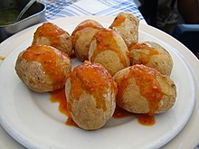
The papas arrugadas, small, wrinkled potatoes with a sea salt crust, form the traditional basis for many Canarian dishes. The potatoes - small varieties that are only grown in the Canary Islands - are cooked unpeeled with sea salt; the amount of salt can be up to a quarter of the weight of the potatoes. After the water has boiled off, they are dried on a low flame for about 20 to 30 minutes until they become wrinkled. They are eaten With the salt-coated bowl, usually in conjunction with a spicy mojo.
Mojo
Mojos are cold sauces that are mostly made from vinegar, oil, and garlic. They are served as a dip and side dish with a wide variety of dishes such as meat, fish and bread, and especially with the wrinkled Canarian potatoes (papas arrugadas). However, the exact recipe is a secret of the manufacturer or restaurant owner. There are the following variants:
Red mojo (Mojo picante or Mojo picón) contains, in addition to vinegar and oil, cumin (cumin), chillies, possibly fresh pureed peppers, and salt and pepper, Mojo Rojo Suave is the milder variant.
Green Mojo (Mojo Verde) gets its color either from fresh parsley (Mojo de Perejil) or preferably with fresh coriander (Mojo cilantro). Avocados and green peppers are also used, as well as garlic, salt and cumin. As Mojo Verde Suave the milder version is also referred to here. The green mojo is often served with fish.
Wine
The DO (Denominación de origen) La Palma. On 864 ha[5] is in the three subzones of Fuencaliente Las Manchas, Hoyo de Mazo and North del Palma Wine grown. In addition to the traditional noble sweet Malvasia, mainly strong dry white and red wines (up to 15%) are produced, the quality of which has increased significantly in recent years. The main grape varieties grown are Gual, Malvasía, Listán blanco, Albillo, Verdello (white) and Almuñeco (Listán negro), Listán Prieto (red) and Negramoll (red) as well as others, only on the Canary Islands, which were spared from the phylloxera plague , vorkommende alte Rebsorten. Bekannte Bodegas sind die Bodegas Teneguía in Fuencaliente, die Bodegas Noroeste de La Palma in Tijarafe und die S.A.T. Bodegas el Hoyo in Villa de Mazo.
nightlife
public holidays
The holiday calendar is redefined every year by the different autonomous regions of Spain. Fällt beispielsweise ein Feiertag auf einen Sonntag, wird in manchen Fällen der darauf folgende Montag oder der vorangehende Freitag ebenfalls zum Feiertag bestimmt. Daneben gibt es noch örtliche Feiertage.
Hier die Feiertage, die auf der gesamten Insel gelten.
- January 1st: Año Nuevo
- 6. Januar: Los Reyes : An diesem Tag bekommen die Kinder in Spanien ihre Weihnachtsgeschenke, die die Heiligen Drei Könige mitbringen.
- 19th March: San José
- Maundy Thursday: Jueves Santo
- Good Friday: Viernes Santo
- Easter Sunday: Pascua
- 1st of May: Día del Trabajo
- 30th May: Día de las Islas Canarias (Tag der Kanaren)
- Pentecost Sunday: Pentecostés
- Corpus Christi: Corpus Christí
- Ascension of Christ: Ascensíon del Señor
- July 25th: Santiago Apóstel, Apostle James
- 15th of August: Asunción (Maria Himmelfahrt)
- 12th of October: Día de la Hispanidad (Tag der Entdeckung Amerikas)
- 1st of November: Todos los Santos (Allerheiligen)
- 6. Dezember: Día de la Constitución (Tag der Verfassung)
- December 8th: Immaculada Concepción (Maria Empfängnis)
- 25 December: Navidad
security
Im Allgemeinen ist La Palma ein sehr sicheres Reiseziel. Bis vor wenigen Jahren wurden Autos und Häuser oft nicht einmal abgeschlossen. Dennoch sollte man eine gewisse Vorsicht, die man zu Hause als selbstverständlich ansieht, auch auf La Palma walten lassen und zum Beispiel keine Wertgegenstände offen im Auto liegen lassen.
Die Notfallnummer lautet 112.
Während die deutsche Bundesrepublik in Santa Cruz ein Honorarkonsulat betreibt, sitzt das nächste eidgenössische Konsulat in Las Palmas de Gran Canaria und das nächste österreichische Honorarkonsulat in Santa Cruz de Tenerife.
climate

| Jan | Feb | March | Apr | May | Jun | Jul | Aug | Sep | Oct | Nov | Dec | |||
|---|---|---|---|---|---|---|---|---|---|---|---|---|---|---|
| Mean highest air temperature in ° C | 20.0 | 20.1 | 20.6 | 21.0 | 22.0 | 23.5 | 25.0 | 25.8 | 26.1 | 24.9 | 23.1 | 21.3 | O | 22.8 |
| Average air temperature in ° C | 17.6 | 17.6 | 18.0 | 19.5 | 21.1 | 22.6 | 23.5 | 23.6 | 22.4 | 20.6 | 18.8 | 20.3 | O | 20.5 |
| Mean lowest air temperature in ° C | 15.2 | 15.1 | 15.4 | 15.9 | 17.0 | 18.8 | 20.3 | 21.1 | 21.0 | 19.9 | 18.1 | 16.3 | O | 17.8 |
| Average water temperature in ° C | 18 | 18 | 18 | 19 | 19 | 20 | 22 | 23 | 22 | 22 | 21 | 20 | O | 20.2 |
| Rainy days in the month | 10 | 6 | 6 | 5 | 3 | 1 | 0 | 0 | 2 | 5 | 11 | 10 | Σ | 59 |
literature
Reiseführer:
- : La Palma. Michael Müller Verlag, Erlangen, 2007 (6. Auflage), ISBN 978-3899533682 , S. 255. Neuauflage im Feb. 2010
- : La Palma (Reise Know-How). Reise Know-How Verlag Rump, Bielefeld, 2008 (5. Auflage), ISBN 978-3831716586 , S. 396.
- : La Palma: Erholen und Wandern auf der grünsten der Kanarischen Inseln. pmv, Frankfurt/Main, 2005 (7. Auflage), ISBN 978-3898591416 , S. 318.
- : DuMont Reise-Taschenbuch La Palma. DuMont Reiseverlag, Ostfildern, 2008 (3. Auflage), ISBN 978-3770159376 , S. 240.
Wanderführer:
- : Wanderührer La Palma. 1998. PDF
- : MM-Wandern: Wanderführer La Palma. Michael Müller Verlag, Erlangen, 2010, ISBN 978-3899535105 , S. 192. erscheint im März 2010
- : La Palma, das Wanderparadies. 30 ausgewählte Routen. Editorial Desniveel S.L., Madrid, ISBN 978-84-9829-104-9 , S. 160. Verzeichnis der Verkausstellen auf La Palma or online bestellbar
- : Wandern auf La Palma. 30 Touren. DuMont Reiseverlag, Ostfildern, 2008 (4. Auflage), ISBN 978-3770150274 , S. 156.
- : La Palma. Wanderführer. Kompass Karten, Rum bei Innsbruck, 2004, ISBN 978-3854917595 , S. 128.
- Rainer Olzem, Timm Reisinger: Geologischer Wanderführer La Palma, 2. erweiterte und aktualisierte Auflage 2018, ISBN 978-3-00-059133-4
- : Genusswandern auf La Palma. Bruckmann, München, 2007, ISBN 978-3765444227 , S. 143.
- : La Palma und El Hierro. Sunflower Books, London, 2003 (3. Auflage), ISBN 1-85691-215-9 , S. 136. deutsche Ausgabe
- : Landscapes of La Palma. Sunflower Books, London, 2008 (5. Auflage), ISBN 1-85691-365-1 , S. 136. englischsprachige Ausgabe
- : La Palma. Die schönsten Küsten- und Bergwanderungen - 63 Touren. Bergverlag Rother, Ottobrunn, 2008 (9. Auflage), ISBN 978-3763342464 , S. 232.
- : La Palma. Bike Guide: 19 Rad- und Mountainbike-Touren. Bergverlag Rother, Ottobrunn, 2003, ISBN 978-3763350155 , S. 112.
- : Mountainbike Guide La Palma. Verlag hellblau, Essen, 2007, ISBN 978-3937787145 , S. 224.
cards
- La Palma 1:30 000: Walking Map. Freytag & Berndt, Wien, 2007, ISBN 978-3707903461 .
- La Palma 1:50 000. Kompass-Wanderkarten, Blatt 232. Wander-, Bike-, Freizeit- und Straßenkarte. Kompass Karten, Rum bei Innsbruck, 2009, ISBN 978-3854910299 .
- La Palma Wanderkarte 1:50 000. Goldstadtverlag, Pforzheim, 2008.
Weiterführende Literatur:
- Harald Braem: Auf den Spuren der Ureinwohner. Ein archäologischer Reiseführer für die Kanaren. Editorial Zech, Santa Úrsula, 2008, ISBN 978-8493485733
- Horst Uden: Unter dem Drachenbaum. Legenden und Überlieferungen von den Kanarischen Inseln. Editorial Zech, Santa Úrsula, 2007, ISBN 978-8493310820
- David Bramwell, Zoë Bramwell: Flora de las Islas Canarias. Guía de bolsillo. Editorial Rueda S.L., Madrid, 1997, ISBN 8472071022
- David Bramwell, Zoë Bramwell: Flores silvestres de las Islas Canarias. Editorial Rueda S.L., Madrid, 1990, ISBN 8472071286
- P. Schönfelder: Die Kosmos-Kanarenflora: Über 850 Arten der Kanarenflora und 48 tropische Ziergehölze., Franckh-Kosmos Verlag, Stuttgart, 2. Aufl., 2006, ISBN 978-3440107508
- Marcos Báez: Mariposas de Canarias. Editorial Rueda S.L., Madrid, ISBN 8472071103
- J.M. Castro, S. Eigen, W. Göbel: La Palma. Die Canarische Insel. Essays über Land und Leute. (Text in Deutsch / Spanisch), Konkursbuchverlag, Tübingen, 4. Aufl., 1996, ISBN 978-3887690229
- C. Gehrke, A. Linares, W. Göbel (Hrsg.): CANARIAS - Kanarisches Lesebuch. Erzählungen, Essays, Lyrik, Fotografien, Zeichnungen, Gemälde. (Text in Deutsch / Spanisch) Konkursbuchverlag, Tübingen, 4. Aufl. 1996, ISBN 978-3-88769-338-1
- Gregor Gumpert (Hrsg.): Kanarische Inseln. Ein Reisebegleiter. Insel Verlag, Frankfurt/ M, 2004
- Harald Körke: Noch ein verdammter Tag im Paradies. Erzählungen. Konkursbuchverlag, Tübingen, 8. Aufl., 2001, ISBN 978-3887690328
- Harald Körke: Beutels Fiesta. Roman. Konkursbuchverlag, Tübingen
- Udo Oskar Rabsch: Kaiman links. Roman. Konkursbuchverlag, Tübingen, 2001, ISBN 978-3887691318
- Harald Braem: Tanausú - König der Guanchen. Historischer Roman von La Palma. Editorial Zech, Santa Úrsula, 2003, ISBN 978-8493310806
- Vicente Sánchez Araña: Cocina Canaria. Editorial Everest, León, 4. Aufl., 2006, ISBN 978-8424122676
- : Meridian Zero. indepently published, 2017, ISBN 978-1-5212-2861-6 ; 312 pages (German). Die Kanarischen Inseln jenseits des Massentourismus, Reisebericht mit vielen Hintergrund-Infos auch zu Teneriffa
Web links
- La Agencia Estatal de Meteorología aktuelle Wetterdaten für Santa Cruz de la Palma mit 7 Tage Vorhersage
- Meteos de El Roque de Los Muchachos aktuelle Wetterdaten des Nordic Optical Telescope (NOT)
- Offizielle Tourismus-Webseite
- Website des Inselrates (Cabildo Insular)