| Kenyan coastline | |
| Information | |
| Country | |
|---|---|
| Largest city | Mombasa |
| Ocean | Indian |
| Watercourse | Tana |
| Area | 17 997 km² |
| Population | 2 914 022 hab. (2009) |
| Density | 161,92 inhab./km² |
| Official languages | English, swahili |
| Spindle | UTC 03:00 |
| Location | |
 2 ° 49 ′ 19 ″ S 40 ° 14 ′ 53 ″ E | |
the kenyan coastline is the region of Kenya along the Indian Ocean at an average depth of 40 km. It includes, from north to south, the counties of Lamu, Tana River (southern part), Kilifi, Mombasa and Kwale.
Understand
Weather
If the climate is tropical on the entire coast, it is the rainfall and maximum temperatures that distinguish the different sub-regions. In the south, a heavy rainy season between mid-April and the end of May and a small wet season in October and November. The further north you go, the more the climate is tropical savanna with a single rainy season between mid-April and mid-June. The entire coastline being in the southern hemisphere, the meteorological summer, with daytime temperatures exceeding 32 ° C, in the south, is between January and March while in the north, they border the 30 ° C between November and April with the highest maxima in March.
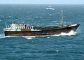
The dhow
Dhow Where dhow (داو in Arab and dau in swahili) is a vernacular name for various types of Indian Ocean vessels mainly used for coastal or inter-island fishing and cabotage. Traditionally, they are built of wood and rigged with one or two masts each carrying a trapezoidal sail with a truncated front point known as the “Arab sail”. Currently, the largest dhows are deprived of their sails, even their mature, and are powered by a diesel engine.
The main types of dhows encountered along the Kenyan coast are:
- the baggala Where baghlah long from 30 to 50 m and being able to embark from 150 to 500 tons, it is the largest of the dhows. Her stern is square,
- the bhum Where boom similar to baggala but her stern is pointed,
- the jahazi provided with a forecastle, and sometimes a forecastle, it is the most typical of the dhows of the Kenyan coast. They are still built, among other things, to Matondoni on Lamu Island,
- the zarug Where kidau is the smallest and fastest of the dhows. Equipped with a single mast, it is mainly used for fishing. Six times a year, speed races between vidau (plural of kidau) are organized at Lamu.
.JPG/120px-Sur-Dhow_(2).JPG)
One baggala.
One bhum.

One jahazi.

Race vidau during the Lamu Cultural Festival.
.JPG/120px-Sur-Dhow_(2).JPG)


Regions
It is common practice in tourist guides and travel agencies to describe as the "southern coast" the part of the coast located to the south of the island of Mombasa, or less than 100 km, and from "North coast" all the rest, that is to say approximately 430 km.
Cities
In alphabetical order :
- 1 Guy – 2,904 inhab. (2009). Locality of Tana River County.
- 2 Gazi – 5,222 inhab. (2009). Coastal locality of County Kwale.
- 3 Kilifi – 122,899 inhab. (2009). Chief town of Kilifi County.
- 4 Kwale – 19,880 inhab. (2009). County town of Kwale.
- 5 Lamu –
 18,382 inhab. (2009). Chief town of Lamu County.
 - 6 Malindi – 84,150 inhab. (2009). Coastal town in County Kilifi.
- 7 Mombasa –
 1,208,333 inhab. (2019). Chief town of Mombasa County and 2e largest Kenyan city.
 - 8 Mtwapa – 48,625 inhab. (2009). County town of Kilifi.
- 9 Ukunda – 62,529 inhab. (2009). County town of Kwale.
- 10 Watamu – 10,030 inhab. (2009). Coastal town in County Kilifi.
Other destinations
Mombasa
- 1 Mombasa Maritime National Park and Marine Reserve – Marine protected area off Mombasa.
South side
- 2 Shimba Hills National Reserve – Protected area in the County Kwale.
- 3 Mwaluganje Elephant Sanctuary – Protected area in County Kwale.
- 4 Diani Beach – Resort town of Ukunda in County Kwale.
- 5 Kisite-Mpunguti Maritime National Park and Marine Reserve – marine protected area in County Kwale.
North Coast

- 6 Mijikenda sacred kayas forests –
 Cultural site registered with Unesco World Heritage in the Kilifi County and whose practices and traditions which are perpetuated there are inscribed on the UNESCO list of intangible heritage in need of urgent safeguarding. The kayas are around fifty fortified villages located in eleven distinct forest sites north of Mombasa. Built from XVIe century, they were gradually abandoned from the middle of the XXe century but are still considered today as the abodes of ancestors and revered as the repositories of spiritual beliefs. Since this is a sacred land for the Mijikenda, here more than elsewhere, the visitor should respect the place.
 - 7 Arabuko-Sokoke National Park – Protected forest area in Kilifi County.
- 8 Watamu Maritime National Park –
 Marine protected area in County Kilifi.
 - 9 Ruins of Gede – Ruins of an ancient Swahili city in County Kilifi.
- 10 Malindi Maritime National Park – Marine protected area south of the town of Malindi in County Kilifi.
- 11 Tana River Primate Reserve (Tana River Primate Reserve) – Protected area for the conservation of the Mangabey de la Tana and the Rufous-headed bay colobus, two primate species recognized by the International Union for the Conservation of Nature as “Endangered”.
- 12 Takwa ruins – Ruins of an ancient Swahili city in the Lamu County.
- 13 Kiunga Maritime National Park – Marine protected area in Lamu County.
- 14 Kwaggavoetpad Nature Reserve – Mainly aquatic natural protected area in Lamu County.
- 15 Dodori National Reserve – Protected area in Lamu County.
- 16 Boni National Reserve – Protected area in the Garissa County.
To go
By plane
The Kenyan coast has an international airport at Mombasa (Moi International Airport), two regional airports in Ukunda (Ukunda Airport) and Malindi (Malindi Airport) as well as three airfields in Mombasa (Bamburi Airport), Lamu (Manda Airport) and Kiwayu (Kiwayu Airstrip).
- 1 Moi International Airport (Moi International Airport IATA : MBA) Barack Obama Road, 80100 Changamwe (Mombasa),
 254 716 694306 (cellphone)
 - 2 Ukunda Airport (IATA : UKA) Airport Road, Diani Beach
- 3 Malindi Airport (IATA : MYD) Kilifi Road, Malindi
- 4 Manda Airport (IATA : LAU) Kwae Road, Manda
- 5 Bamburi Airfield (IATA : BMK) Off Old Shimo La Tewa Road, Bamburi
- 6 Kiwayu Airfield (IATA : KWY) Mkokoni Road, Ashuwei
On a boat
By train
The only way to reach the Kenyan coastline by train is to arrive, departing from Nairobi, with the Madaraka Express To Mombasa.
- 7 Miritini Station (Mombasa Railway Station) Dongo - Kundu Bypass, Miritini
 (2018) adult: 1 000 KES in 2e class, 3 000 KES in 1D class, price not yet known in 1D class business. – Train Madaraka Express. Maximum baggage weight: 30 kg.
By bus
The bus station of Mombasa is the focal point for all the coaches that crisscross the coast.
- 8 Bus station Mwembe Tayari Road, 80100 Mombasa
The four main companies are:
- Spanish Coach Express (destination : Nairobi) ;
- Coast Bus (destination : Nairobi) ;
- Modern Coast (destinations: Nairobi, Malindi, Dar es Salaam) ;
- TTS Express (destination : Lamu) ;
- Pwani Tawakal (destination : Lamu).
By car
From Nairobi
The distance in kilometers between Nairobi and Mombasa is 525 km. Departing from City center of Nairobi, take the international road A104 (Huhuru Highway) towards Jomo Kenyatta International Airport and Athi River.
Nairobi └──> A104 Athi River └──> A109 Manyani └──> C103Malindi │ └──> B8 Minjila │ └──> C112Lamu └──> A109 Mariakani └──> C107Kilifi └──> A109Mombasa
Circulate
By car
Except in Mombasa County, the road network is not very dense. International roads recognizable by the letter "A" followed by a number written in yellow on a green background and national roads recognizable by the letter "B" followed by a number written in white on a red background are asphalted. Regional roads recognizable by the letter “C” followed by a number written in white on a brown background are not always asphalted outside the built-up areas. Local roads recognizable by the letter "D" followed by a number written in white on a yellow background are never asphalted.
From Mombasa :
- A109 (also part of the trans-African route n ° 8 towards Lagos in Nigeria) → Nairobi
- branch to the left at Changamwe : C110 → theMoi international airport
- right turn at Mazeras: C111 → Kaloleni
- right turn at Mariakani: C107 → Kaloleni
- A14 → Horo Horo (border of south-eastern Tanzania), Tanga and Dar es Salaam
- B8 → Mtwapa, Kilifi, Malindi, Guy and the A3 (13 km West of Garissa)
From Malindi :
To buy
Always keep in mind that, as everywhere in Africa, it is common practice to haggle in small shops and among small artisans. The price that is asked of you is often overrated, especially if you are not very local.
- kanga Where khanga (invariable word): piece of fabric decorated with patterns in bright colors to be worn by women around the waist or chest, or to tie on the head. It is decorated with a border running along all four sides and featuring different designs as well as a proverb in swahili ;
- kikoi (vikoi plural): piece of fabric decorated with stripes or brightly colored checks to wear around the waist or chest or to tie on the head. In wool, it is then a garment rather intended for men,
- batik : Originally from Java, the batik technique has been known for centuries on the Kenyan coast. These are pieces of fabric not woven but painted by hand. Due to the printing technique, machine washing is not recommended,
- ndala (invariable word): leather sandals adorned with pearls. Handcrafted, no pair is identical,
- objects carved in accordance with the Muslim heritage which does not use images but prefers to use geometric patterns.
- silver jewelry.
Eat

The great culinary specialties are the accommodation of fish and seafood (especially crab). But, if there is a tradition, it is the incorporation of coconut in many recipes such as wali ya tui ("Basmati rice with coconut milk"), the kuku wa kupaka ("Chicken in coconut milk"), the mbaazi ("Chickpeas with turmeric and coconut milk"), mahamri ("Cardamom-flavored coconut milk donuts").
A specialty that is tending to disappear, given the rarity of the species off the Kenyan coast, is the preparation of shark meat (dad in swahili). This one is buried in sand, subjected to the solar rays, during three days before being accommodated.
A specialty specific to the Giriama and Chonyi of the region of Kilifi is rat meat (panya in Swahili and kadzora in giriama). This is grilled and visually looks like grilled fish.
- (in) Sheikha Agil, Recepies from Swahili Delicacies, flight. 1: A taste from the East African Coast, 2014, 62 p. (read online) - 29 Swahili cooking recipes.
Three restaurants stand out for their extraordinary environment:
- TO Mombasa, 1 the Tamarind Dhow (catering during a dhow cruise);
- in Mtwapa, 2 the Moorings (Kenya's only floating restaurant);
- in Ukunda, 3 Ali Barbours Cave (in a fossil coral cave formed there are between 120 to 180,000 years).
Have a drink / Go out
A place out of the ordinary for its extraordinary environment:
- TO Lamu, 1 the Floating Bar and Restaurant (boat anchored in the middle of a natural sea channel).
Security
 | Emergency telephone number: All emergency services:112 |